開啟輔助訪問
 找回密碼
 立即加入

20P.Trevor 登陸約克角半島後於卡灣重整 二顛登陸北領地

簽到天數: 868 天

[LV.10]以壇為家III

jrchang5|2019-3-23 00:58 | 顯示全部樓層
本帖最後由 jrchang5 於 2019-3-23 15:17 編輯

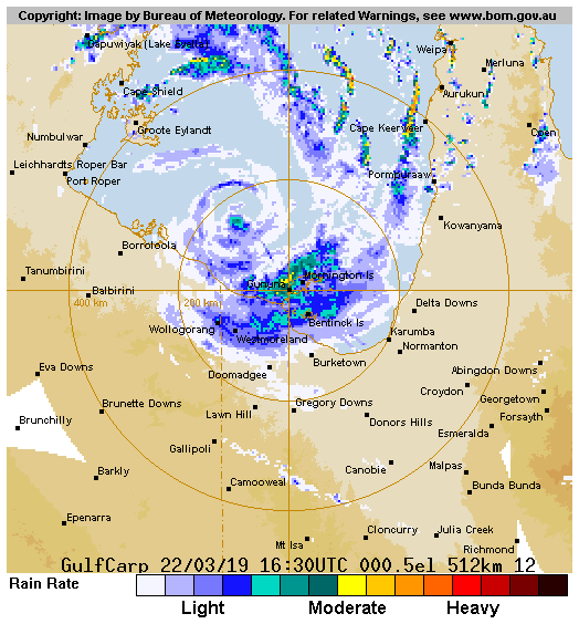
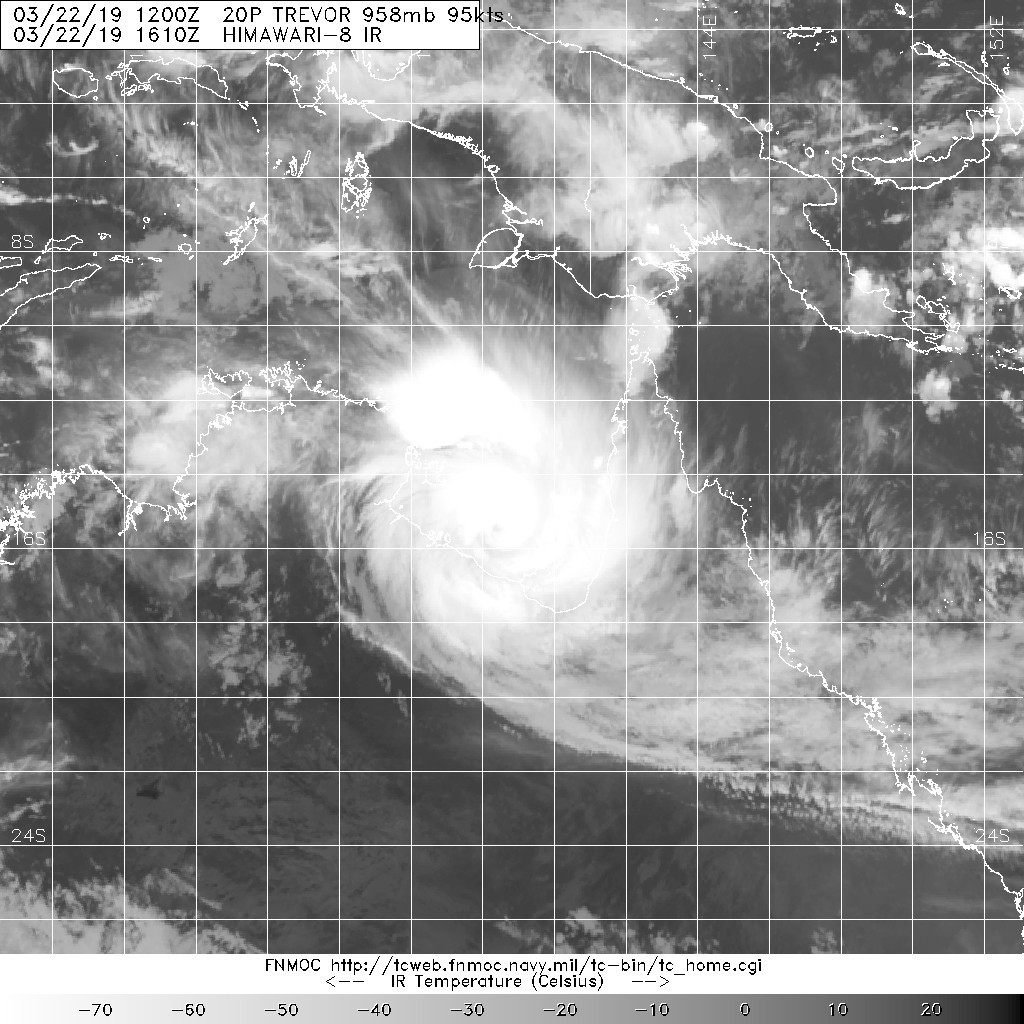
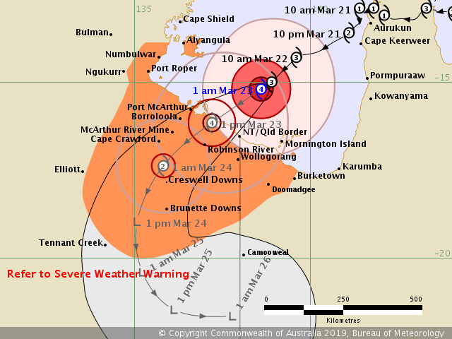
BoM判定22/15Z升格為澳式C4,近中心最大風速達175km/h(約95kts),逐漸逼近北領地沿岸。
IDD20150

Australian Government Bureau of Meteorology
Northern Territory
Tropical Cyclone Warning Centre

Media: Transmitters serving the area between Port Roper and the NT/Qld border are requested to USE the Standard Emergency Warning Signal before broadcasting the following warning.

TOP PRIORITY FOR IMMEDIATE BROADCAST
TROPICAL CYCLONE WARNING

TROPICAL CYCLONE ADVICE NUMBER 44
Issued at 1:57 am ACST [2:27 am AEST] on Saturday 23 March 2019

Headline:
Dangerous conditions are developing along the southern Gulf of Carpentaria as Severe Tropical Cyclone Trevor nears the coast. The cyclone is expected to cross the coast during Saturday morning between Port McArthur and the NT/Qld border.

Areas Affected:
Warning Zone
Alyangula in the Northern Territory to Burketown in Queensland, and inland parts of the Carpentaria District, Barkly District and the northwest Gulf Country, including Groote Eylandt, Mornington Island, Borroloola, Robinson River, Wollogorang, McArthur River, Cape Crawford, Creswell Downs, Brunette Downs and Doomadgee.

Watch Zone
None.

Cancelled Zone
None.

Details of Severe Tropical Cyclone Trevor at 12:30 am ACST [1:00 am AEST]:
Intensity: Category 4, sustained winds near the centre of 175 kilometres per hour with wind gusts to 250 kilometres per hour.

Location: within 30 kilometres of 15.2 degrees South 138.6 degrees East, estimated to be 170 kilometres north northwest of Mornington Is and 265 kilometres east northeast of Borroloola.

Movement: southwest at 11 kilometres per hour.

Severe Tropical Cyclone Trevor has intensified to category 4 in the last few hours. It is expected to cross the Northern Territory coast on Saturday morning.

Hazards:
The VERY DESTRUCTIVE core of Severe Tropical Cyclone Trevor is forecast to cross the southern coast of the Gulf of Carpentaria between Port McArthur and the NT/Queensland Border Saturday morning with VERY DESTRUCTIVE WINDS, with gusts to 275 km/h near the cyclone centre as it approaches and crosses the coast.

Coastal residents between Port Roper and the NT/Queensland Border are specifically warned of a VERY DANGEROUS STORM TIDE as the cyclone centre approaches the coast. Tides will rise significantly above the normal high tide, with DAMAGING WAVES and VERY DANGEROUS FLOODING during Friday night and Saturday.

As the cyclone approaches the coast, a STORM TIDE is also expected between the NT/QLD border and Burketown. Large waves may produce minor flooding along the foreshore. People living in areas likely to be affected by this flooding should take measures to protect their property as much as possible and be prepared to help their neighbours.

GALES, with gusts to 120 km/h are occuring on Mornington Island, Sweers Island and on the mainland coast between Port McArthur in the Northern Territory and Burketown in Queensland. Gales are also expected to extend to Groote Eylandt over the next couple of hours as the system approaches the coast. GALES are expected to extend inland into the western Carpentaria, central Barkly Districts and the northwest Gulf Country on Saturday morning. Inland locations which may be affected on Saturday and early Sunday include Doomadgee, Creswell Downs, Cape Crawford, Robinson River, McArthur River, Wollogorang and Brunette Downs.

HEAVY RAINFALL is likely to cause significant stream rises and localised flooding in the eastern Carpentaria District from early Saturday. A Flood Watch has been issued for Carpentaria Coastal Rivers and the Barkly in the Northern Territory.

HEAVY RAINFALL will also develop over the western Gulf Country in Queensland as the cyclone moves inland tomorrow. Flood Warnings are current in Queensland for the Daintree and Mossman Rivers, as well as a broader Flood Watch for catchments north of Cairns to Kowanyama, the western Gulf Country, and the Channel Country.

Recommended Action:
People between the NT/QLD border and Burketown, and in areas extending inland to Doomadgee, should complete preparations quickly and be prepared to shelter in a safe place, especially securing boats and property.

- Information is available from your local government.

- For cyclone preparedness and safety advice, visit Queensland's Disaster Management Services website (www.disaster.qld.gov.au).

- For emergency assistance call the Queensland State Emergency Service (SES) on 132 500 (for assistance with storm damage, rising flood water, fallen trees on buildings or roof damage).

NTES advises:

Residents from Alyangula to NT/Qld border, including Groote Eylandt and Borroloola and inland areas of the Carpentaria and Barkly Districts

-Prepare you home and yard for severe cyclone;

-Follow direction and advice of local emergency services;

-Prepare for wet and windy conditions and consider the situation when the cyclone travels far inland;

Further advice on cyclone emergencies is available at www.securent.nt.gov.au. Please ensure that friends, family and neighbours have heard and understood this message, particularly new arrivals to the area.Further advice on cyclone emergencies is available at www.securent.nt.gov.au. Please ensure that friends, family and neighbours have heard and understood this message, particularly new arrivals to the area.

Next Advice:
The next advice will be issued by 5:00 am ACST Saturday 23 March [5:30 am AEST Saturday 23 March].

This advice is available on telephone NT-1300 659 211 and QLD-1300 659 212
IDD65001.png IDR361.gif 20190322.1610.himawari-8.ir.20P.TREVOR.95kts.958mb.15S.138.8E.100pc.jpg bd_lalo-animated.gif rbtop_lalo-animated.gif

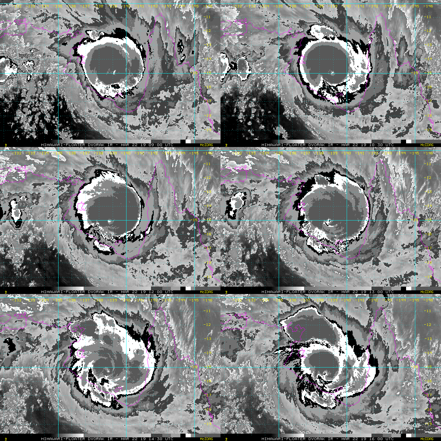
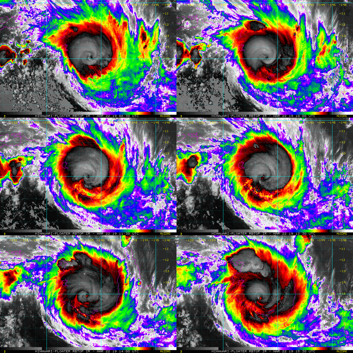
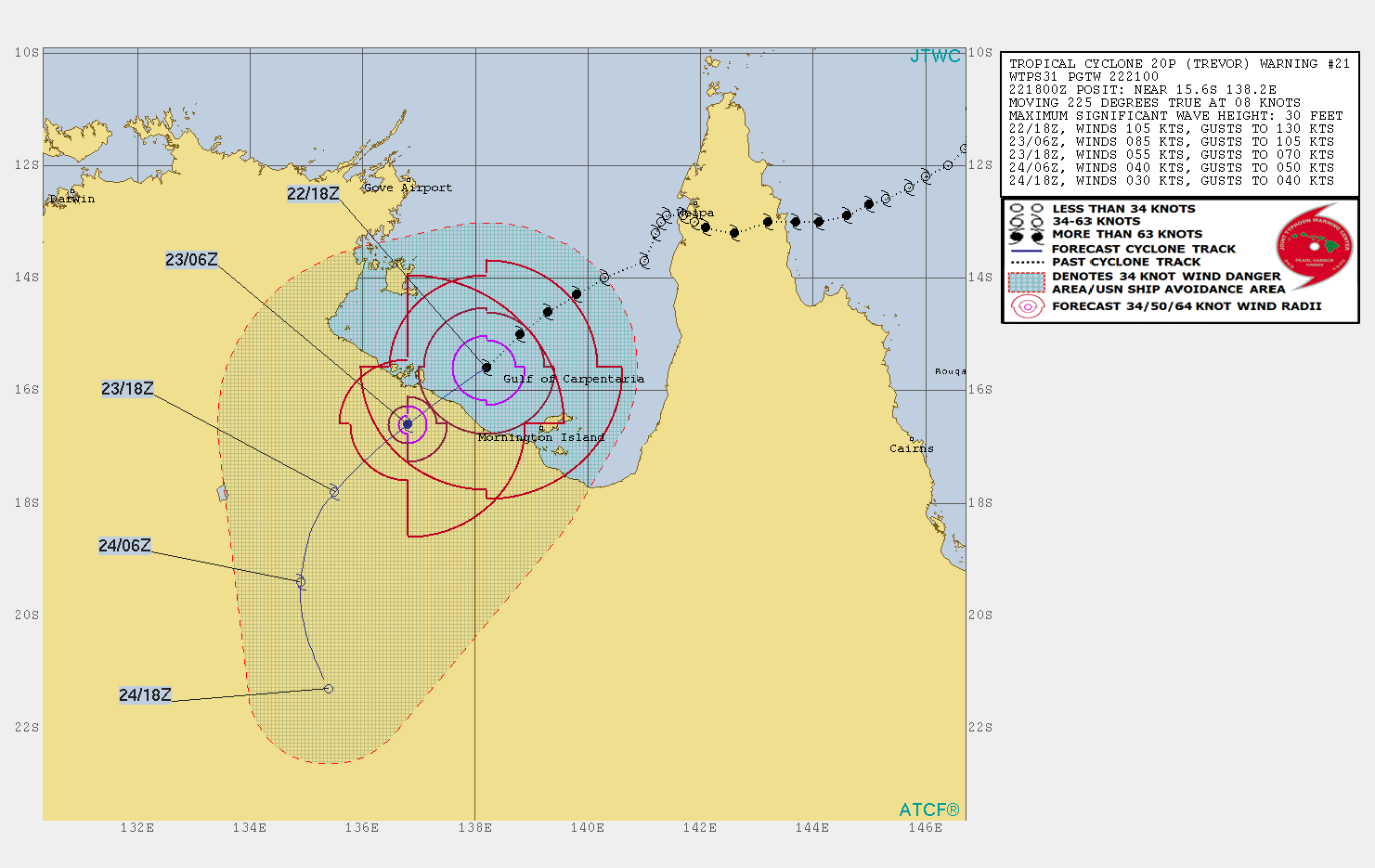
22/18Z,JTWC認定近中心最大風速升至105kts,BoM則仍維持95kts,強度已達二次巔峰。
sh202019.19032206.gif 2019-03-23 15.16.51.png


回復

使用道具 舉報

簽到天數: 868 天

[LV.10]以壇為家III

jrchang5|2019-3-23 10:08 | 顯示全部樓層
本帖最後由 jrchang5 於 2019-3-23 15:29 編輯

由最新衛星雲圖及雷達降水回波圖觀之,風眼大約於23/01Z左右登陸北領地沿岸。
BoM判定00Z登陸前近中心最大風速略降為90kts(165km/h),仍維持澳式C4等級。
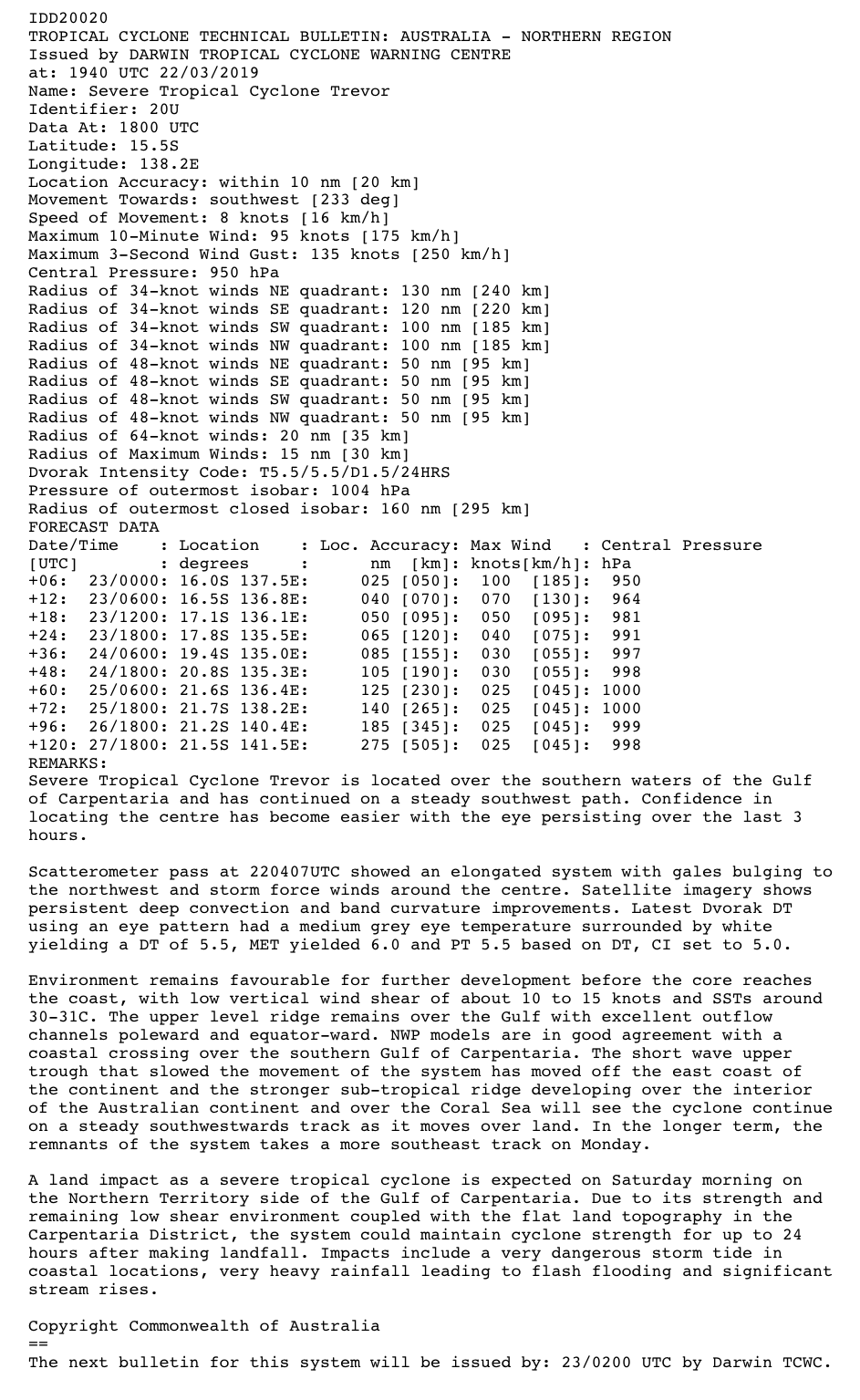
IDD20020
TROPICAL CYCLONE TECHNICAL BULLETIN: AUSTRALIA - NORTHERN REGION
Issued by DARWIN TROPICAL CYCLONE WARNING CENTRE
at: 0158 UTC 23/03/2019
Name: Severe Tropical Cyclone Trevor
Identifier: 20U
Data At: 0000 UTC
Latitude: 15.9S
Longitude: 137.6E
Location Accuracy: within 10 nm [20 km]
Movement Towards: southwest [235 deg]
Speed of Movement: 7 knots [13 km/h]
Maximum 10-Minute Wind: 90 knots [165 km/h]
Maximum 3-Second Wind Gust: 125 knots [230 km/h]
Central Pressure: 955 hPa
Radius of 34-knot winds NE quadrant: 130 nm [240 km]
Radius of 34-knot winds SE quadrant: 120 nm [220 km]
Radius of 34-knot winds SW quadrant: 100 nm [185 km]
Radius of 34-knot winds NW quadrant: 100 nm [185 km]
Radius of 48-knot winds NE quadrant: 50 nm [95 km]
Radius of 48-knot winds SE quadrant: 50 nm [95 km]
Radius of 48-knot winds SW quadrant: 50 nm [95 km]
Radius of 48-knot winds NW quadrant: 50 nm [95 km]
Radius of 64-knot winds: 20 nm [35 km]
Radius of Maximum Winds: 15 nm [30 km]
Dvorak Intensity Code: T5.0/5.5/D1.0/24HRS STT:W0.5/6HRS
Pressure of outermost isobar: 1004 hPa
Radius of outermost closed isobar: 160 nm [295 km]
FORECAST DATA
Date/Time    : Location    : Loc. Accuracy: Max Wind   : Central Pressure
[UTC]        : degrees     :      nm  [km]: knots[km/h]: hPa
+06:  23/0600: 16.4S 136.7E:     015 [030]:  070  [130]:  973
+12:  23/1200: 17.0S 136.0E:     030 [055]:  050  [095]:  988
+18:  23/1800: 17.6S 135.5E:     040 [075]:  040  [075]:  994
+24:  24/0000: 18.4S 135.1E:     055 [100]:  030  [060]:  998
+36:  24/1200: 19.9S 134.9E:     075 [135]:  030  [055]:  999
+48:  25/0000: 21.0S 135.6E:     095 [170]:  030  [050]: 1000
+60:  25/1200: 21.4S 136.8E:     110 [210]:  025  [045]: 1001
+72:  26/0000: 21.4S 137.7E:     130 [245]:  025  [045]: 1001
+96:  27/0000: 20.6S 139.5E:     175 [325]:  025  [045]: 1001
+120: 28/0000: 21.2S 139.9E:     265 [490]:  025  [045]: 1000
REMARKS:
Severe Tropical Cyclone Trevor was located from Mornington Island radar close to
the southern coast of the Gulf of Carpentaria at 00UTC. The cyclone has
maintained an overall southwest track with small . Concentric eyewalls are
evident in the radar signature with radii around 8nm and 22nm, providing good
fix accuracy.

Recent observations at Centre Island, around 70km west of the cylone centre and
just outside of the outer eyewall have sustained storm force winds with gusts
reaching 75kn/139kph at 0017UTC.  

AMSR2 scatterometer pass at 221635UTC indicated the gale area reaching the
southern tip of Groote Eylandt and covering much of southern Gulf waters and
hurricane force winds near the centre. Satellite imagery shows an irregular eye
persisting for the past 6 hours surrounded by cold cloud. Dvorak DT using an eye
pattern with light grey eye temperature surrounded by white yielding a DT of
5.0, after subtracting 0.5 for an irregular eye. MET/PAT=5.0. FT based on DT,
with CI held at 5.5 [90kn mean wind].

The environment remains favourable for the circulation to remain intact while
traversing the low topography of the Carpentaria District during the next 24-36
hours with low vertical wind shear of about 10 to 15 knots. NWP models are in
good agreement with a steady southwest track over land under the influence of a
sub-tropical ridge over the Coral Sea. In the longer term, the remnants of the
system takes a more southeast track on Monday.

Copyright Commonwealth of Australia
==
The next bulletin for this system will be issued by: 23/0800 UTC by Darwin TCWC.

IDD65001 (1).png IDR361 (1).gif

JTWC 23/00Z近中心最大風速亦略降為100kts,並發出Final Warning。
WTPS31 PGTW 230300
MSGID/GENADMIN/JOINT TYPHOON WRNCEN PEARL HARBOR HI//
SUBJ/TROPICAL CYCLONE 20P (TREVOR) WARNING NR 022//
RMKS/
1. TROPICAL CYCLONE 20P (TREVOR) WARNING NR 022   
   01 ACTIVE TROPICAL CYCLONE IN SOUTHPAC
   MAX SUSTAINED WINDS BASED ON ONE-MINUTE AVERAGE
   WIND RADII VALID OVER OPEN WATER ONLY
    ---
   WARNING POSITION:
   230000Z --- NEAR 16.2S 137.4E
     MOVEMENT PAST SIX HOURS - 230 DEGREES AT 10 KTS
     POSITION ACCURATE TO WITHIN 030 NM
     POSITION BASED ON EYE FIXED BY A COMBINATION OF
     SATELLITE, RADAR AND SYNOPTIC DATA
   PRESENT WIND DISTRIBUTION:
   MAX SUSTAINED WINDS - 100 KT, GUSTS 125 KT
   WIND RADII VALID OVER OPEN WATER ONLY
   RADIUS OF 064 KT WINDS - 035 NM NORTHEAST QUADRANT
                            045 NM SOUTHEAST QUADRANT
                            040 NM SOUTHWEST QUADRANT
                            030 NM NORTHWEST QUADRANT
   RADIUS OF 050 KT WINDS - 070 NM NORTHEAST QUADRANT
                            085 NM SOUTHEAST QUADRANT
                            075 NM SOUTHWEST QUADRANT
                            060 NM NORTHWEST QUADRANT
   RADIUS OF 034 KT WINDS - 130 NM NORTHEAST QUADRANT
                            155 NM SOUTHEAST QUADRANT
                            140 NM SOUTHWEST QUADRANT
                            115 NM NORTHWEST QUADRANT
   REPEAT POSIT: 16.2S 137.4E
    ---
   FORECASTS:
   12 HRS, VALID AT:
   231200Z --- 17.3S 135.9E
   MAX SUSTAINED WINDS - 070 KT, GUSTS 085 KT
   WIND RADII VALID OVER OPEN WATER ONLY
   VECTOR TO 24 HR POSIT: 215 DEG/ 09 KTS
    ---
   24 HRS, VALID AT:
   240000Z --- 18.7S 134.8E
   MAX SUSTAINED WINDS - 045 KT, GUSTS 055 KT
   WIND RADII VALID OVER OPEN WATER ONLY
   VECTOR TO 36 HR POSIT: 180 DEG/ 08 KTS
    ---
   36 HRS, VALID AT:
   241200Z --- 20.3S 134.8E
   MAX SUSTAINED WINDS - 035 KT, GUSTS 045 KT
   WIND RADII VALID OVER OPEN WATER ONLY
   DISSIPATING AS A SIGNIFICANT TROPICAL CYCLONE OVER LAND
   VECTOR TO 48 HR POSIT: 155 DEG/ 06 KTS
    ---
   EXTENDED OUTLOOK:
   48 HRS, VALID AT:
   250000Z --- 21.4S 135.4E
   MAX SUSTAINED WINDS - 030 KT, GUSTS 040 KT
   WIND RADII VALID OVER OPEN WATER ONLY
   DISSIPATED AS A SIGNIFICANT TROPICAL CYCLONE OVER LAND
    ---
REMARKS:
230300Z POSITION NEAR 16.5S 137.0E.
TROPICAL CYCLONE (TC) 20P (TREVOR), LOCATED APPROXIMATELY 438 NM
EAST-SOUTHEAST OF DARWIN, AUSTRALIA, HAS TRACKED SOUTHWESTWARD AT 10
KNOTS OVER THE PAST SIX HOURS. ANIMATED MULTISPECTRAL SATELLITE
IMAGERY (MSI) DEPICTS TIGHTLY-CURVED BANDING WRAPPING INTO A SMALL
5NM EYE. A 230011Z MHS 89GHZ COMPOSITE MICROWAVE IMAGE DEPICTS A
COMPACT EYEWALL SURROUNDING A MCROWAVE EYE FEATURE, WHICH IS
STRADDLING THE COASTLINE. ANIMATED RADAR IMAGERY FROM THE MORNINGTON
ISLAND RADAR INDICATES THE EYEWALL IS FRAGMENTING AS THE CENTER
TRACKS INLAND ALTHOUGH CONVECTIVE BANDING OVER THE EASTERN
SEMICIRCLE REMAINS VIGOROUS. THE INITIAL INTENSITY IS ASSESSED AT
100 KNOTS BASED ON DVORAK CURRENT INTENSITY ESTIMATES OF 5.5 (102
KNOTS) FROM ALL AGENCIES. BASED ON THE EYE EVIDENT IN MSI, THERE IS
GOOD CONFIDENCE IN THE INITIAL POSITION. TC 20P IS TRACKING
SOUTHWESTWARD ALONG THE NORTHWEST PERIPHERY OF A SUBTROPICAL RIDGE
(STR) POSITIONED TO THE SOUTH AND SOUTHEAST BUT IS FORECAST TO TURN
SOUTHWARD TO SOUTH-SOUTHEASTWARD AFTER TAU 24 AS THE STR WEAKENS IN
RESPONSE TO AN APPROACHING SHORTWAVE TROUGH. THE SYSTEM SHOULD
WEAKEN STEADILY AS IT TRACKS FURTHER INLAND WITH DISSIPATION
EXPECTED BY TAU 48. BASED ON THE TIGHT GROUPING OF DYNAMIC MODEL
VORTEX TRACKERS, THERE IS HIGH CONFIDENCE IN THE JTWC FORECAST
TRACK, WHICH IS POSITIONED CLOSE TO THE MULTI-MODEL CONSENSUS. THIS
IS THE FINAL WARNING ON THIS SYSTEM BY THE JOINT TYPHOON WRNCEN
PEARL HARBOR HI. THE SYSTEM WILL BE CLOSELY MONITORED FOR SIGNS OF
REGENERATION.//
NNNN

sh2019.gif 20190323.0110.himawari-8.vis.20P.TREVOR.100kts.957mb.16.2S.137.4E.100pc.jpg rgb_lalo-animated.gif rbtop_lalo-animated (1).gif


評分

參與人數 1水氣能量 +20 收起 理由
t02436 + 20

查看全部評分

回復

使用道具 舉報

簽到天數: 868 天

[LV.10]以壇為家III

jrchang5|2019-3-24 11:10 | 顯示全部樓層
BoM判定23/18Z降為熱帶低壓。
IDD20020
TROPICAL CYCLONE TECHNICAL BULLETIN: AUSTRALIA - NORTHERN REGION
Issued by DARWIN TROPICAL CYCLONE WARNING CENTRE
at: 1935 UTC 23/03/2019
Name: Ex-Tropical Cyclone Trevor
Identifier: 20U
Data At: 1800 UTC
Latitude: 18.4S
Longitude: 135.2E
Location Accuracy: within 20 nm [35 km]
Movement Towards: south southwest [214 deg]
Speed of Movement: 12 knots [22 km/h]
Maximum 10-Minute Wind: 30 knots [55 km/h]
Maximum 3-Second Wind Gust: 45 knots [85 km/h]
Central Pressure: 998 hPa
Radius of 34-knot winds NE quadrant:   
Radius of 34-knot winds SE quadrant:   
Radius of 34-knot winds SW quadrant:   
Radius of 34-knot winds NW quadrant:   
Radius of 48-knot winds NE quadrant:   
Radius of 48-knot winds SE quadrant:   
Radius of 48-knot winds SW quadrant:   
Radius of 48-knot winds NW quadrant:   
Radius of 64-knot winds:
Radius of Maximum Winds:   
Dvorak Intensity Code: n/a
Pressure of outermost isobar: 1004 hPa
Radius of outermost closed isobar: 200 nm [370 km]
FORECAST DATA
Date/Time    : Location    : Loc. Accuracy: Max Wind   : Central Pressure
[UTC]        : degrees     :      nm  [km]: knots[km/h]: hPa
+06:  24/0000: 19.1S 134.8E:     030 [060]:  030  [055]: 1000
+12:  24/0600: 19.7S 134.8E:     045 [080]:  030  [055]:  999
+18:  24/1200: 20.3S 134.8E:     055 [105]:  030  [055]:  999
+24:  24/1800: 20.8S 134.9E:     070 [130]:  030  [055]:  998
+36:  25/0600: 22.0S 136.2E:     090 [165]:  030  [055]:  999
+48:  25/1800: 22.8S 138.4E:     110 [200]:  030  [055]:  999
+60:  26/0600: 23.5S 139.9E:     130 [235]:  030  [055]:  998
+72:  26/1800: 24.2S 142.8E:     145 [270]:  030  [055]:  999
+96:  27/1800: 26.8S 146.2E:     190 [355]:  030  [055]:  994
+120: 28/1800:             :              :            :     
REMARKS:
At 3:30am CST Sunday, the remnants of tropical cyclone Trevor were located by
satellite over land around 320km inland from the southwestern coast of the Gulf
of Carpentaria. Deep convection is now completely absent from the central
circulation, with the nearest convective band displaced some 120 nautical miles
to the east.

Dvorak analysis is not possible with the system over land. There is currently
little in the way of peripheral observations. McArthur River Mine, some 250km to
the north of the current position, was the last station to experience marginal
category 1 wind gusts prior to 8pm CST Saturday. Standard decay rates suggest
the system would be close to or below TC thresholds. Intensity is therefore set
at 30 knots.

NWP models are in good agreement with a southwest track initially, steered by
the mid level subtropical ridge. The system will be steered to the south during
Sunday as an approaching shortwave trough weakens the ridge. The remnants of the
cyclone will track southeast on Monday towards Queensland.

Copyright Commonwealth of Australia
==
There will be no further bulletins for this system.
IDD65001.png rgb_lalo-animated.gif rbtop_lalo-animated.gif


回復

使用道具 舉報

1234
快速回覆
您需要登錄後才可以回帖 登錄 | 立即加入

本版積分規則

本平台僅供學術討論之用,預報應以氣象局為準

威普網站虛擬主機贊助公司

臺灣第一個天氣類型社群平台 即時天氣資訊、精準颱風動態

線上客服
FB傳送訊息
廣告行銷
精準行銷 物超所值
官方粉專
發佈 快速回復 返回頂部 返回列表