簽到天數: 3291 天 [LV.Master]伴壇終老
|
 t02436|2018-10-11 05:49
|
顯示全部樓層
1730Z判定以135節強度登陸
000
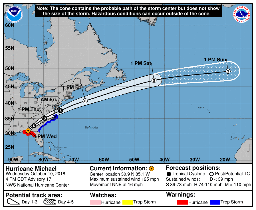
WTNT44 KNHC 102054
TCDAT4
Hurricane Michael Discussion Number 17
NWS National Hurricane Center Miami FL AL142018
400 PM CDT Wed Oct 10 2018
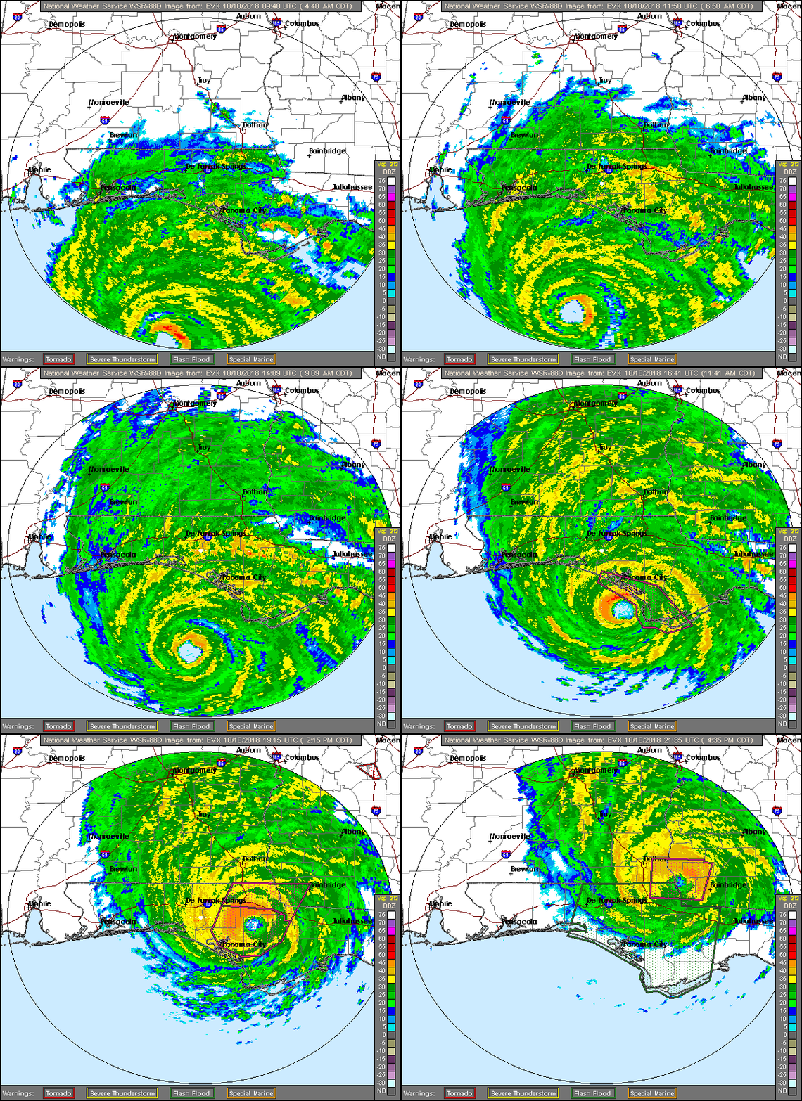
Data from an Air Force Force Reserve Hurricane Hunter aircraft and
NWS WSR-88D radar data showed that Michael continued to strengthen
until it made landfall around 1730 UTC (12:30 PM CDT) along the
coast of the Florida Panhandle between Mexico Beach and Tyndall Air
Force Base. The aircraft found peak 700-mb flight-level winds of
152 kt during its final pass through southeast eyewall just before
Michael made landfall. There were SFMR measurements of 132-138 kt,
but the validity of those observations are questionable since they
occurred in shallow water and were flagged. The landfall intensity
was estimated at 135 kt (155 mph), which makes Michael the strongest
hurricane to make landfall in the continental U.S. since Andrew
(1992). The minimum pressure at landfall was estimated at 919 mb,
which is the third lowest landfall pressure in the United States. A
University of Florida/Weatherflow observing site measured a minimum
pressure of 920.2 mb.
Now that the entire eyewall has moved over land, the Doppler radar
velocities have decreased and the initial intensity has been lowered
to 110 kt. Although steady weakening is expected as Michael moves
over the southeast U.S. through Thursday morning, hurricane-force
winds will continue to penetrate inland over the Florida Panhandle,
southeastern Alabama, and southwestern Georgia through this evening.
The circulation is forecast to emerge over the western Atlantic
Thursday night and Friday, where intensification as an extratropical
cyclone is expected. The extratropical low is expected to remain
quite strong while to moves over the north Atlantic through the
weekend. The low is expected to be absorbed by another low pressure
area over the eastern Atlantic by day 5.
Michael is moving northeastward of 030/14 kt, and the hurricane
should continue to accelerate northeastward as it becomes embedded
within the mid-latitude westerlies. The post-tropical cyclone should
turn east-northeastward and further accelerate as it moves over the
north Atlantic. The track guidance remains tightly clustered, but
has trended faster this cycle, and the NHC forecast has been
adjusted accordingly.
Gale- to storm-force winds are expected over portions of the
Mid-Atlantic coast as Michael exits the U.S. east coast and becomes
post-tropical. Non-tropical high wind watches, warnings, and
advisories have been issued by local NWS offices for wind hazards in
these areas north of Duck, North Carolina.
Key Messages:
1. Life-threatening storm surge continues along portions of the
Florida Panhandle, Big Bend, and Nature Coast. The worst storm surge
is expected to continue between Tyndall Air Force Base and Aucilla
River, where 5 to 10 feet of inundation is still ongoing.
2. Michael will continue to produce life-threatening hurricane-force
winds well inland across portions of the Florida Panhandle,
southeast Alabama, and southwestern Georgia this evening as the core
of the hurricane continues to move inland.
3. Heavy rainfall from Michael could produce life-threatening flash
flooding from the Florida Panhandle and Big Bend region into
portions southeast Alabama, Georgia, the Carolinas, and southeast
Virginia.
4. Tropical storm conditions will affect portions of the southeast
U.S. coast from northeast Florida through North Carolina, and
tropical storm warnings are in effect for these areas.
FORECAST POSITIONS AND MAX WINDS
INIT 10/2100Z 30.9N 85.1W 110 KT 125 MPH...INLAND
12H 11/0600Z 32.6N 83.2W 60 KT 70 MPH...INLAND
24H 11/1800Z 35.1N 79.6W 40 KT 45 MPH...INLAND
36H 12/0600Z 37.6N 74.4W 50 KT 60 MPH...OVER WATER
48H 12/1800Z 40.7N 66.2W 60 KT 70 MPH...POST-TROP/EXTRATROP
72H 13/1800Z 46.7N 43.5W 60 KT 70 MPH...POST-TROP/EXTRATROP
96H 14/1800Z 49.2N 19.0W 50 KT 60 MPH...POST-TROP/EXTRATROP
120H 15/1800Z...ABSORBED
$$
Forecaster Brown

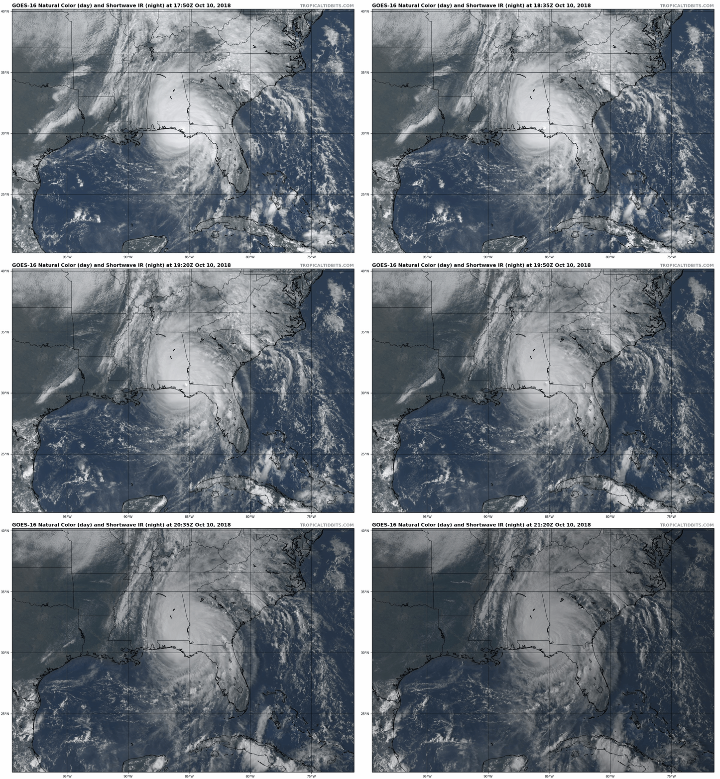
登陸雲圖及雷達


|
|