開啟輔助訪問
 找回密碼
 立即加入

10L.Joyce 由溫帶氣旋轉化而來

簽到天數: 2141 天

[LV.Master]伴壇終老

2018-9-12 20:24 | 顯示全部樓層
  基本資料  
編號    :10 L
擾動編號日期:2018 09 12 19
撤編日期  :2018 09 00 00
96L.INVEST.15kts-1016mb-36.0N-40.0W

20180912.1130.msg-4.vis.96L.INVEST.15kts.1016mb.36N.40W.100pc.jpg

NHC:40%  
2. A non-tropical area of low pressure located several hundredmiles west-southwest of the Azores is producing a large area ofshowers and thunderstorms and gale-force winds. This system couldgradually acquire tropical or subtropical characteristics during thenext couple of days while it meanders over the northeastern AtlanticOcean, and before it becomes absorbed by a larger trough of lowpressure. For more information, see High Seas Forecasts issued bythe National Weather Service.* Formation chance through 48 hours...medium...40 percent.* Formation chance through 5 days...medium...50 percent.

two_atl_2d2.png

評分

參與人數 1水氣能量 +15 +1 收起 理由
t02436 + 15 + 1

查看全部評分

回復

使用道具 舉報

簽到天數: 601 天

[LV.9]以壇為家II

霧峰追風者|2018-9-13 03:27 | 顯示全部樓層
NHC 展望提升至90%
2. Satellite images indicate that a strong area of low pressure located
a little more than 600 miles west-southwest of the Azores is rapidly
becoming better organized and a subtropical or tropical storm
appears to be forming. If this trend continues, advisories will be
initiated later today or tonight. The low is forecast to move toward
the southwest for the next couple of days, and then turn to the
northeast behind Hurricane Helene.  For more information, see High
Seas Forecasts issued by the National Weather Service.
* Formation chance through 48 hours...high...90 percent.
* Formation chance through 5 days...high...90 percent.
two_atl_2d2 (2).png 20180912.1830.msg-4.ir.96L.INVEST.40kts.1006mb.34.5N.41.7W.100pc.jpg


回復

使用道具 舉報

簽到天數: 601 天

[LV.9]以壇為家II

霧峰追風者|2018-9-13 07:36 | 顯示全部樓層
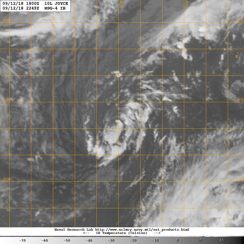
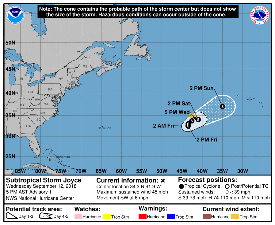
NHC 21Z命名Joyce,判定為副熱帶風暴。
973
WTNT45 KNHC 122040
TCDAT5

Subtropical Storm Joyce Discussion Number   1
NWS National Hurricane Center Miami FL       AL102018
500 PM AST Wed Sep 12 2018

The strong low pressure system which the NHC has been monitoring in
the north Atlantic for a couple of days has developed a cyclonically
curved band of deep convection near the center, and scatterometer
data indicate that the winds are near 40 kt.  Since the system is
still vertically stacked with an upper-low, it is then classified
as a subtropical cyclone at this time.  However, the cyclone is
gaining organization while it is acquiring tropical characteristics.
The NHC forecast calls for Joyce to transform into a tropical system
in about 12 to 24 hours.  Since the ocean is warm, some slight
strengthening is possible during the next 3 days.  After that time,
Joyce will be over cooler waters and should then be absorbed by a
larger extratropical low.

Joyce has been moving southwestward or 225 degrees at 5 kt, steered
by the northerly flow around the subtropical high which has been
steering Florence and to west of the mid-latitude trough which
is forcing Helene to recurve. In a couple of days, global models
indicate that the steering pattern will change as the trough
amplifies, and Joyce should then turn toward the northeast with an
increase in forward speed.


FORECAST POSITIONS AND MAX WINDS

INIT  12/2100Z 34.3N  41.9W   40 KT  45 MPH
12H  13/0600Z 33.7N  42.6W   40 KT  45 MPH...TROPICAL STORM
24H  13/1800Z 33.0N  43.5W   40 KT  45 MPH
36H  14/0600Z 32.5N  43.5W   45 KT  50 MPH
48H  14/1800Z 32.5N  43.5W   50 KT  60 MPH
72H  15/1800Z 34.0N  41.0W   50 KT  60 MPH
96H  16/1800Z 37.0N  35.0W   40 KT  45 MPH
120H  17/1800Z...ABSORBED

$$
Forecaster Avila
204204_5day_cone_no_line_and_wind.png 20180912.2245.msg4.x.ir1km_bw.10LJOYCE.40kts-1006mb-345N-417W.100pc.jpg

回復

使用道具 舉報

簽到天數: 601 天

[LV.9]以壇為家II

霧峰追風者|2018-9-13 11:11 | 顯示全部樓層
目前北大相當的熱鬧,有4旋共舞,不過巔峰已過。
two_atl_0d0.png irng8kml.GIF

回復

使用道具 舉報

簽到天數: 601 天

[LV.9]以壇為家II

霧峰追風者|2018-9-15 03:55 | 顯示全部樓層
判定為熱帶風暴,受到08L導引加速東北移動。
716
WTNT45 KNHC 141442
TCDAT5

Tropical Storm Joyce Discussion Number   8
NWS National Hurricane Center Miami FL       AL102018
1100 AM AST Fri Sep 14 2018

Joyce has again changed little in organization since the last
advisory, with several small bands of convection to the east and
northeast of the partly exposed center.  The initial intensity
remains 35 kt in agreement with the latest satellite estimates from
TAFB and the CIMSS satellite consensus.

The initial motion is now 180/7.  Joyce is currently being steered
by the larger and stronger Helene to its east, and a southward to
southeastward motion is expected for the next 12 h or so.  As
Helene passes to the east-northeast of Joyce, Joyce should turn
eastward and northeastward with a faster forward speed due to the
approach of a mid-latitude trough from the west.  The global models
have again trended toward a faster northeastward motion after 24 h,
and the NHC track forecast has been adjusted to be faster and a
little farther to the east.

There is no change to the intensity forecast philosophy from the
previous advisory.  Southwesterly upper-level winds are forecast to
increase over the cyclone within the next day or two, which should
prevent Joyce from strengthening.  The NHC forecast calls for little
change in wind speed over the next 36 h, then shows weakening as the
shear increases further.  The global models mostly dissipate Joyce
by day 4, but the system could lose its deep convection and become
post-tropical before that time.


FORECAST POSITIONS AND MAX WINDS

INIT  14/1500Z 31.6N  44.6W   35 KT  40 MPH
12H  15/0000Z 31.3N  44.3W   35 KT  40 MPH
24H  15/1200Z 32.0N  42.9W   35 KT  40 MPH
36H  16/0000Z 33.2N  41.0W   35 KT  40 MPH
48H  16/1200Z 34.6N  38.4W   30 KT  35 MPH
72H  17/1200Z 36.0N  32.0W   30 KT  35 MPH
96H  18/1200Z...DISSIPATED

$$
Forecaster Beven
144836_5day_cone_no_line_and_wind.png two_atl_0d0 (1).png 20180914.1900.msg4.x.vis2km.10LJOYCE.35kts-1003mb-315N-444W.100pc.jpg

回復

使用道具 舉報

簽到天數: 3291 天

[LV.Master]伴壇終老

t02436|2018-9-17 00:54 | 顯示全部樓層
15Z降格TD,將轉向南落,也將逐漸消散。
947
WTNT45 KNHC 161441
TCDAT5

Tropical Depression Joyce Discussion Number  16
NWS National Hurricane Center Miami FL       AL102018
1100 AM AST Sun Sep 16 2018

Joyce is barely a tropical cyclone at the moment.  The cloud
pattern consists of a low-level swirl with a small patch of deep
convection located about 80 n mi northeast of the center and another
patch of weakening convection well removed from the center in the
northeast quadrant.  Visible satellite images and a partial ASCAT
pass indicate that the circulation of the cyclone has also become
increasingly elongated from northeast to southwest.  Based on the
system's appearance and the satellite intensity estimates, the
initial wind speed is lowered to 30 kt, making Joyce a tropical
depression.

The depression is moving east-northeastward at 16 kt within the
mid-latitude westerlies, and this motion should continue through
tonight.  After that time, the shallow cyclone is expected to slow
down and turn southeastward and then southwestward as it is moves
in the flow on the east side of a building low- to mid-level ridge.
The track models are in fairly good agreement, and little overall
change was made to the previous NHC forecast.

Joyce is currently in a quite hostile environment of 30-40 kt of
west-southwesterly shear.  Even though SSTs are relatively warm,
the ongoing strong shear and nearby dry air should continue to cause
the cyclone to gradually weaken.  Although the NHC forecast shows
Joyce hanging on as a tropical depression for a couple of more days,
it is very possible that the system could degenerate into a trough
or a remnant low at any time during that period.

FORECAST POSITIONS AND MAX WINDS

INIT  16/1500Z 34.7N  34.3W   30 KT  35 MPH
12H  17/0000Z 34.9N  31.4W   30 KT  35 MPH
24H  17/1200Z 34.5N  28.7W   30 KT  35 MPH
36H  18/0000Z 33.6N  27.0W   30 KT  35 MPH
48H  18/1200Z 32.6N  26.7W   25 KT  30 MPH
72H  19/1200Z 30.4N  29.2W   20 KT  25 MPH...POST-TROP/REMNT LOW
96H  20/1200Z...DISSIPATED

$$
Forecaster Cangialosi

144313_5day_cone_with_line.png

vis-animated.gif
回復

使用道具 舉報

快速回覆
您需要登錄後才可以回帖 登錄 | 立即加入

本版積分規則

周子堯@FB

    主題

    帖子

    94萬

    積分

    13級[一級颶風]

    Rank: 13Rank: 13Rank: 13Rank: 13

13級[一級颶風]

發訊息

本平台僅供學術討論之用,預報應以氣象局為準

威普網站虛擬主機贊助公司

臺灣第一個天氣類型社群平台 即時天氣資訊、精準颱風動態

線上客服
FB傳送訊息
廣告行銷
精準行銷 物超所值
官方粉專
發佈 快速回復 返回頂部 返回列表