開啟輔助訪問
 找回密碼
 立即加入

18E.Paul 逐漸北上

簽到天數: 2414 天

[LV.Master]伴壇終老

2018-9-6 07:37 | 顯示全部樓層
  熱帶風暴  
編號:18 E
名稱:Paul

  基本資料  
擾動編號日期:2018 09 04 02
命名日期  :2018 09 09 17
撤編日期  :2018 09 00 00
登陸地點  :

  巔峰時期資料  
近中心最強風速
國家颶風中心(NHC):35 kts
海平面最低氣壓1004 百帕

  過去路徑圖  


  擾動編號資料  
92E.INVEST.20kts.1008mb.13.5N.107W

20180905.2315.goes-15.ircolor.92E.INVEST.20kts.1008mb.13.5N.107W.055pc.jpg

  NHC:20%  
1. A broad area of low pressure centered about 450 miles south-
southwest of Zihuatanejo, Mexico, is producing disorganized showers
and thunderstorms extending well offshore the southern coast of
Mexico.  Upper-level winds are forecast to become more conducive for
development, and a tropical depression could form by early next week
while the system moves slowly west-northwestward at about 10 mph
away from the coast of Mexico.
* Formation chance through 48 hours...low...20 percent.
* Formation chance through 5 days...medium...50 percent.

two_pac_2d1.png

以上資料來自:NHC颱風論壇整理製作
回復

使用道具 舉報

簽到天數: 601 天

[LV.9]以壇為家II

霧峰追風者|2018-9-7 11:04 | 顯示全部樓層
NHC 展望提升至50%。
1. The broad area of low pressure that NHC has been tracking for a
few days is now located several hundred miles south of the southern
tip of Baja California peninsula. Although the shower activity has
not become any better organized during the past few hours,
environmental conditions appear to be conducive for development. A
tropical depression is likely to form by this weekend or early next
week while the system moves slowly toward the west-northwest at
about 10 mph away from the coast of Mexico.
* Formation chance through 48 hours...medium...50 percent.
* Formation chance through 5 days...high...80 percent.
two_pac_2d1.png

回復

使用道具 舉報

簽到天數: 601 天

[LV.9]以壇為家II

霧峰追風者|2018-9-8 02:48 | 顯示全部樓層
NHC 展望提升至70%。
1. An elongated area of low pressure located several hundred miles
south-southwest of the southern tip of Baja California peninsula
continues to produce disorganized shower and thunderstorm activity.
Environmental conditions are expected be conducive for development,
and a tropical depression is likely to form this weekend or early
next week while the system moves slowly west-northwestward away from
the coast of Mexico.
* Formation chance through 48 hours...high...70 percent.
* Formation chance through 5 days...high...90 percent.
two_pac_2d1 (1).png 92E_gefs_latest.png

回復

使用道具 舉報

簽到天數: 3291 天

[LV.Master]伴壇終老

t02436|2018-9-9 00:19 | 顯示全部樓層
升格18E,巔峰上望C1。
506
WTPZ43 KNHC 081436
TCDEP3

Tropical Depression Eighteen-E Discussion Number   1
NWS National Hurricane Center Miami FL       EP182018
800 AM PDT Sat Sep 08 2018

The area of low pressure that NHC has been tracking for several
days has enough organized deep convection this morning to be
classified as a tropical depression.  Some northeasterly shear is
affecting the cyclone, with the apparent center on the northeastern
side of a growing area of deep convection.  The initial wind speed
is set to 30 kt, in accordance with the Dvorak classification from
TAFB.  Gradual strengthening is forecast while the cyclone remains
over warm waters within a light-to-moderate shear environment.
After 72 hours, the water temperatures drop off quite a bit and
weakening should begin.  The NHC forecast is close to, but a little
above, the model consensus near peak intensity to account for the
low bias the model guidance has had for many eastern Pacific storms
this year.

An uncertain initial motion estimate is 290/10.  All of the model
guidance turn the cyclone northwestward by tomorrow as the cyclone
rounds the southwestern side of a mid-level ridge located over
Mexico.  A turn back toward the west-northwest is anticipated in a
few days due to the system coming under the influence of the primary
eastern Pacific subtropical ridge.  For a first advisory, the model
guidance isn't in terrible disagreement, so the NHC prediction will
lie near close to the various consensus and corrected-consensus
aids.

FORECAST POSITIONS AND MAX WINDS

INIT  08/1500Z 16.1N 115.9W   30 KT  35 MPH
12H  09/0000Z 16.6N 116.8W   35 KT  40 MPH
24H  09/1200Z 17.7N 117.8W   40 KT  45 MPH
36H  10/0000Z 18.9N 118.7W   45 KT  50 MPH
48H  10/1200Z 20.1N 119.8W   50 KT  60 MPH
72H  11/1200Z 21.5N 123.0W   65 KT  75 MPH
96H  12/1200Z 23.0N 126.5W   60 KT  70 MPH
120H  13/1200Z 24.5N 129.0W   40 KT  45 MPH

$$
Forecaster Blake
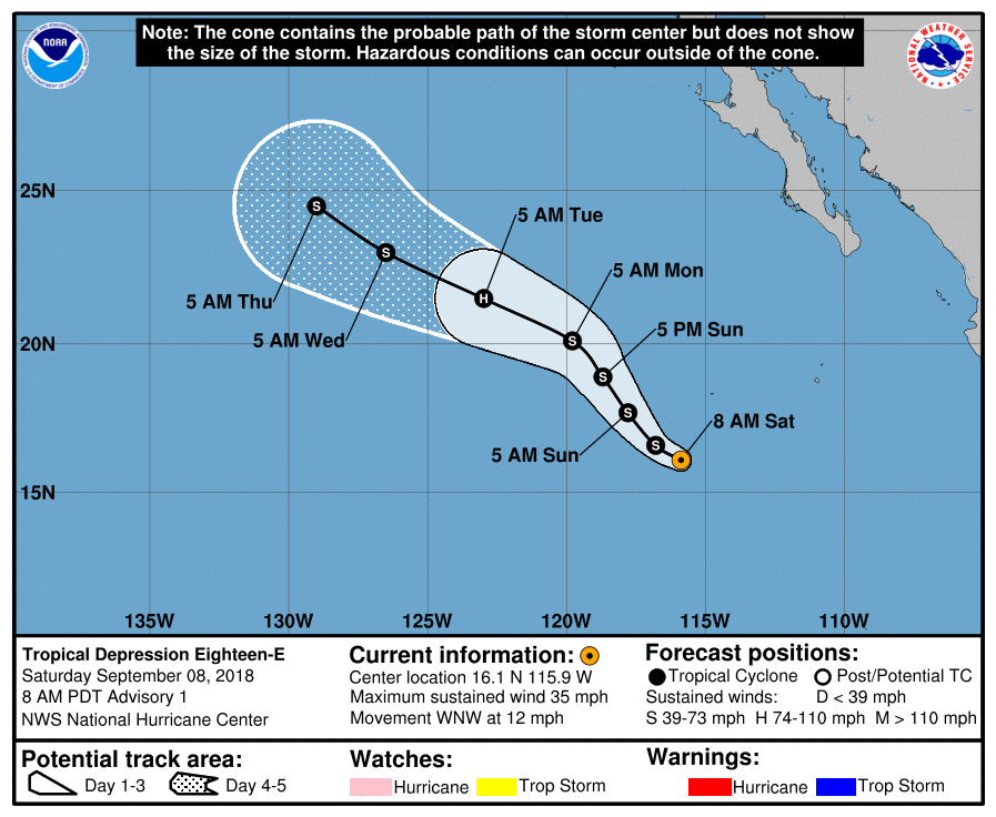
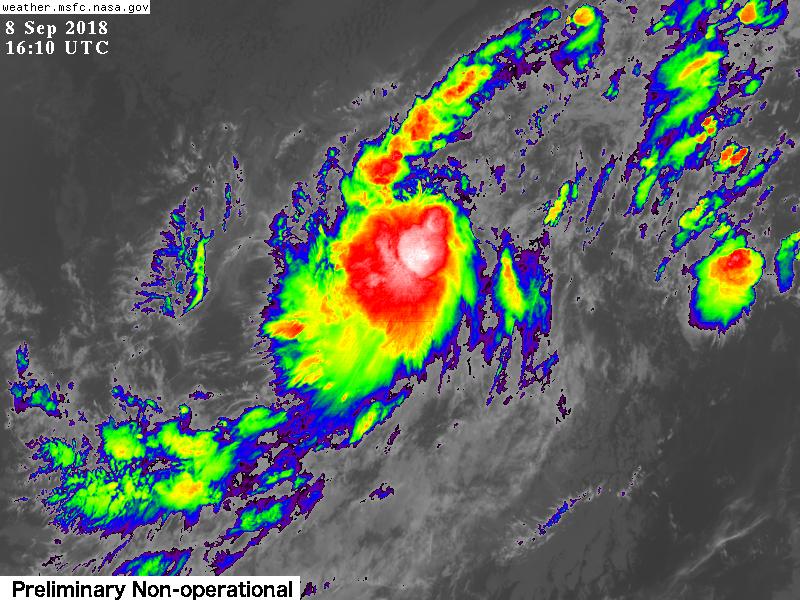
144330_5day_cone_with_line.png

GOES161020182512XKkyy.jpg
回復

使用道具 舉報

簽到天數: 3291 天

[LV.Master]伴壇終老

t02436|2018-9-9 18:23 | 顯示全部樓層
命名Paul
441
WTPZ43 KNHC 090843
TCDEP3

Tropical Storm Paul Discussion Number   4
NWS National Hurricane Center Miami FL       EP182018
200 AM PDT Sun Sep 09 2018

Satellite data indicate that depression has strengthened.  The
cyclone has a large curved band that wraps across the western half
of the circulation, but banding features remain limited to the east
of the center.  A partial ASCAT pass from a few hours ago showed
30-35 kt winds in the southeastern quadrant.  Based on that data and
the 2.5/35 kt Dvorak classification from TAFB, the initial intensity
is increased to 35 kt, making the system Tropical Storm Paul.

Paul will likely strengthen some more during the next couple of days
while it remains over warm waters and in a relatively moist
environment. However, significant strengthening appears unlikely
because of continued moderate east-northeasterly shear during the
next day or so.  The opportunity for intensification should end in a
few days when the system moves over SSTs cooler than 26 deg C and
into a drier and more stable air mass.  The NHC intensity forecast
is again nudged downward, but it still lies at the high end of the
model guidance.

Satellite fixes suggest that Paul has turned sharper to the
northwest than expected.  Smoothing through the fixes yields an
initial motion estimate of 320/7.   A continued northwestward motion
is expected during the next day or two.  After that time, Paul
should turn to the west-northwest in response to a mid-level ridge
to its north and then slow down by the end of the forecast period
when it becomes shallow and is steered by the low-level flow. The
NHC track has been adjusted northward to account for the change in
the initial motion and position.

FORECAST POSITIONS AND MAX WINDS

INIT  09/0900Z 17.1N 117.5W   35 KT  40 MPH
12H  09/1800Z 18.2N 118.2W   40 KT  45 MPH
24H  10/0600Z 19.4N 119.3W   45 KT  50 MPH
36H  10/1800Z 20.6N 120.8W   50 KT  60 MPH
48H  11/0600Z 21.4N 122.6W   50 KT  60 MPH
72H  12/0600Z 22.6N 126.5W   45 KT  50 MPH
96H  13/0600Z 23.5N 129.4W   40 KT  45 MPH
120H  14/0600Z 24.5N 131.3W   30 KT  35 MPH

$$
Forecaster Cangialosi

084508_5day_cone_with_line.png

GOES09002018252ep0vG7.jpg
回復

使用道具 舉報

快速回覆
您需要登錄後才可以回帖 登錄 | 立即加入

本版積分規則

0908morakot

    主題

    帖子

    69萬

    積分

    12級[颶風Hurricane]

    Rank: 12Rank: 12Rank: 12

12級[颶風Hurricane]

發訊息

本平台僅供學術討論之用,預報應以氣象局為準

威普網站虛擬主機贊助公司

臺灣第一個天氣類型社群平台 即時天氣資訊、精準颱風動態

線上客服
FB傳送訊息
廣告行銷
精準行銷 物超所值
官方粉專
發佈 快速回復 返回頂部 返回列表