開啟輔助訪問
 找回密碼
 立即加入

09L.Isaac 西非熱帶波發展 西行進入加勒比海後 減弱消散

簽到天數: 601 天

[LV.9]以壇為家II

2018-9-4 02:59 | 顯示全部樓層
本帖最後由 霧峰追風者 於 2018-9-26 03:40 編輯

  一級颶風  
編號:09 L
名稱:Isaac
800px-Isaac_2018-09-09_1305Z.jpg
  基本資料  
擾動編號日期:2018 09 04 02
命名日期  :2018 09 09 11
撤編日期  :2018 09 15 17
登陸地點  :暫無

  巔峰時期資料  
近中心最強風速 :65 kt
海平面最低氣壓 :993 百帕

  過去路徑圖  
1920px-Isaac_2018_track.png
  擾動編號資料  
92L.INVEST.15kts-1005mb-10.8N-18.5W

20180903.1800.msg-4.ir.92L.INVEST.25kts.1005mb.10.8N.18.5W.100pc.jpg

  NHC : 10%  
1. A tropical wave located more than 400 miles southeast of the Cabo
Verde Islands is producing a large area of disorganized showers and
thunderstorms.  Some slow development of this disturbance is
possible during the next several days while the system moves
westward to west-northwestward across the eastern tropical Atlantic.
* Formation chance through 48 hours...low...10 percent.
* Formation chance through 5 days...medium...40 percent.

two_atl_2d1.png

以上資料來自:NHC、颱風論壇整理製作

評分

參與人數 1水氣能量 +15 +1 收起 理由
king111807 + 15 + 1 熱帶擾動首帖

查看全部評分

回復

使用道具 舉報

簽到天數: 601 天

[LV.9]以壇為家II

霧峰追風者|2018-9-6 02:56 | 顯示全部樓層
NHC 展望提升至70%。
1. Shower activity associated with a broad area of low pressure
centered a couple of hundred miles south-southwest of the Cabo Verde
Islands is gradually becoming better organized.  Environmental
conditions are forecast to be conducive for additional development,
and a tropical depression is expected to form during the next
couple of days while the system moves west-northwestward across the
tropical Atlantic Ocean.
* Formation chance through 48 hours...high...70 percent.
* Formation chance through 5 days...high...90 percent.
two_atl_2d1.png 20180905.1800.msg-4.ir.92L.INVEST.25kts.1007mb.12.4N.27.4W.100pc.jpg

回復

使用道具 舉報

簽到天數: 601 天

[LV.9]以壇為家II

霧峰追風者|2018-9-8 08:25 | 顯示全部樓層
NHC 升格熱帶低壓09L,逐漸西行,巔峰暫時上望75KT。
TTAA00 TJSJ 072234
WKSTC4

DEPRESION TROPICAL NUEVE DISCUSION NUMERO   1
SNM CENTRO NACIONAL DE HURACANES MIAMI FL       AL092018
TRADUCCION POR EL SERVICIO NACIONAL DE METEOROLOGIA SAN JUAN PR
500 PM CDT MIERCOLES 30 DE AGOSTO DE 2017

IMAGENES DEL SATELITE INDICAN QUE LA BAJA PRESION SOBRE EL ESTE DEL
ATLANTICO TROPICAL HA DESARROLLADO UN CENTRO BIEN DEFINIDO Y
SUFICIENTE CONVECCION PARA SER CLASIFICADO COMO DEPRESION TROPICAL,
LA NOVENA DE LA TEMPORADA DE HURACANES 2018 DEL ATLANTICO Y LA
SEGUNDA DEL DIA. LA INTENSIDAD INICIAL ES 30 NUDOS SEGUN LA
CLASIFICACION 2.0 DVORAK DE TAFB Y DATOS DE ASCAT.

LA DEPRESION NO SE HA DESPLAZAD MUCHO HOY Y SE HA MOVIDO
ERRATICAMENTE HACIA EL ESTE RECIENTEMENTE. ESTE MOVIMIENTO LENTO ES
RESULTADO DE UNA VAGUADA MUY DEBIL AL NORTE DE LA DEPRESION TROPICAL
OCHO A SU ESTE. SE ESPERA POCO MOVIMIENTO ESTA NOCHE, PERO SE
PRONOSTICA UN MOVIMIENTO HACIA EL OESTE CON UN AUMENTO GRADUAL EN
LA VELOCIDAD DE TRASLACION A MEDIDA QUE SE DESARROLLE UNA ZONA DE
ALTA PRESION AL NORTE DEL CICLON. LA TRAYECTORIA DEL CNH ESTA CERCA
DE LA GUIA HCCA Y COLOCA EL SISTEMA HACIA LAS ANTILLAS MENORES A
FINALES DEL PERIODO DE PRONOSTICO.

LA DEPRESION ESTA EXPERIMENTANDO ALGUNAS INFLUENCIAS DE VIENTOS
CORTANTES DEL ESTE, POR LO QUE EL CENTRO SE ENCUENTRA AL EXTREMO
ESTE DE LA CONVECCION. SE ESPERA POCO CAMBIO EN LA INTENSIDAD
DURANTE LAS PROXIMAS 12 A 24 HORAS YA QUE EL CICLON AUN SE
DESARROLLA Y DEBIDO A VIENTOS CORTANTES MODERADOS. SIN EMBARGO, SE
ESPERA QUE LOS VIENTOS CORTANTES DISMINUYAN A MENOS DE 10 NUDOS EN
24 HORAS APROXIMADAMENTE. ESTOS VIENTOS MAS FAVORABLES COMBINADOS
CON AGUAS RELATIVAMENTE MAS CALIDAS Y UNA MASA DE AIRE MAS HUMEDA
DEBEN PERMITIR FORTALECIMIENTO CONTINUO MAS TARDE DURANTE EL FIN DE
SEMANA. EXISTE UNA EXTENSION AMPLIA EN LAS GUIAS DE INTENSIDAD, CON
HWRF MOSTRANDO AL SISTEMA CONVIRTIENDOSE EN HURACAN MAYOR Y HMON
MOSTRANDO NINGUN FORTALECIMIENTO. EL PRONOSTICO DE INTENSIDAD DEL
CNH ESTA UN POCO BAJO EL CONSENSO DE LOS MODELOS YA QUE APARENTA QUE
TOMARA MAS TIEMPO QUE EL SISTEMA SE DESARROLLE.

PRONOSTICO DE POSICION Y VIENTOS MAXIMOS

INIC  07/2100Z 13.6N  34.9W   30 KT  35 MPH
12H  08/0600Z 13.9N  35.2W   30 KT  35 MPH
24H  08/1800Z 14.0N  36.2W   30 KT  35 MPH
36H  09/0600Z 14.0N  37.6W   40 KT  45 MPH
48H  09/1800Z 14.0N  39.3W   50 KT  60 MPH
72H  10/1800Z 14.0N  44.0W   60 KT  70 MPH
96H  11/1800Z 14.1N  48.9W   70 KT  80 MPH
120H  12/1800Z 14.5N  54.5W   75 KT  85 MPH

$$

PRONOSTICADOR CANGIALOSI
TRADUCCION VAZQUEZ
avn-animated (1).gif


205852_5day_cone_no_line_and_wind.png
回復

使用道具 舉報

簽到天數: 601 天

[LV.9]以壇為家II

霧峰追風者|2018-9-9 10:52 | 顯示全部樓層
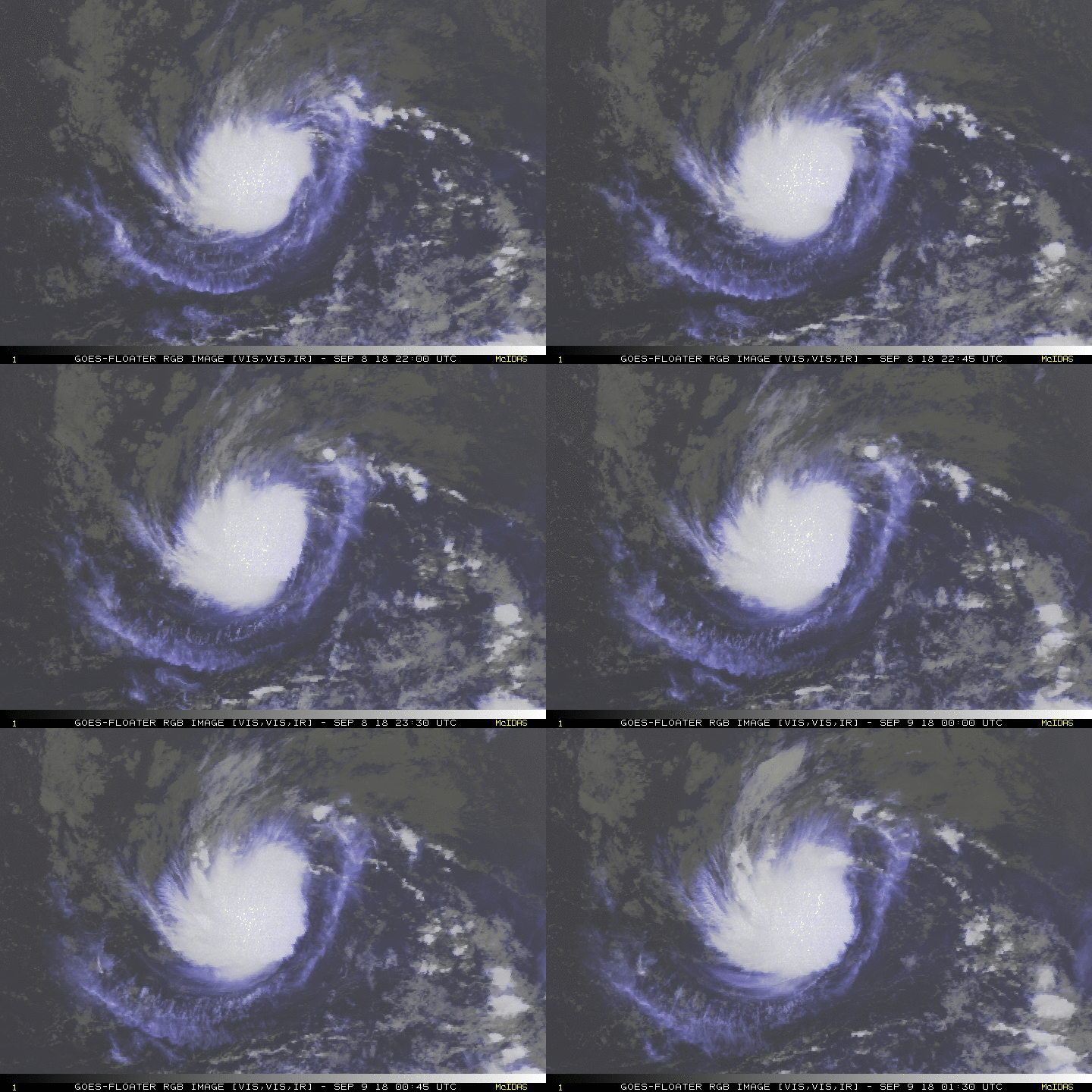
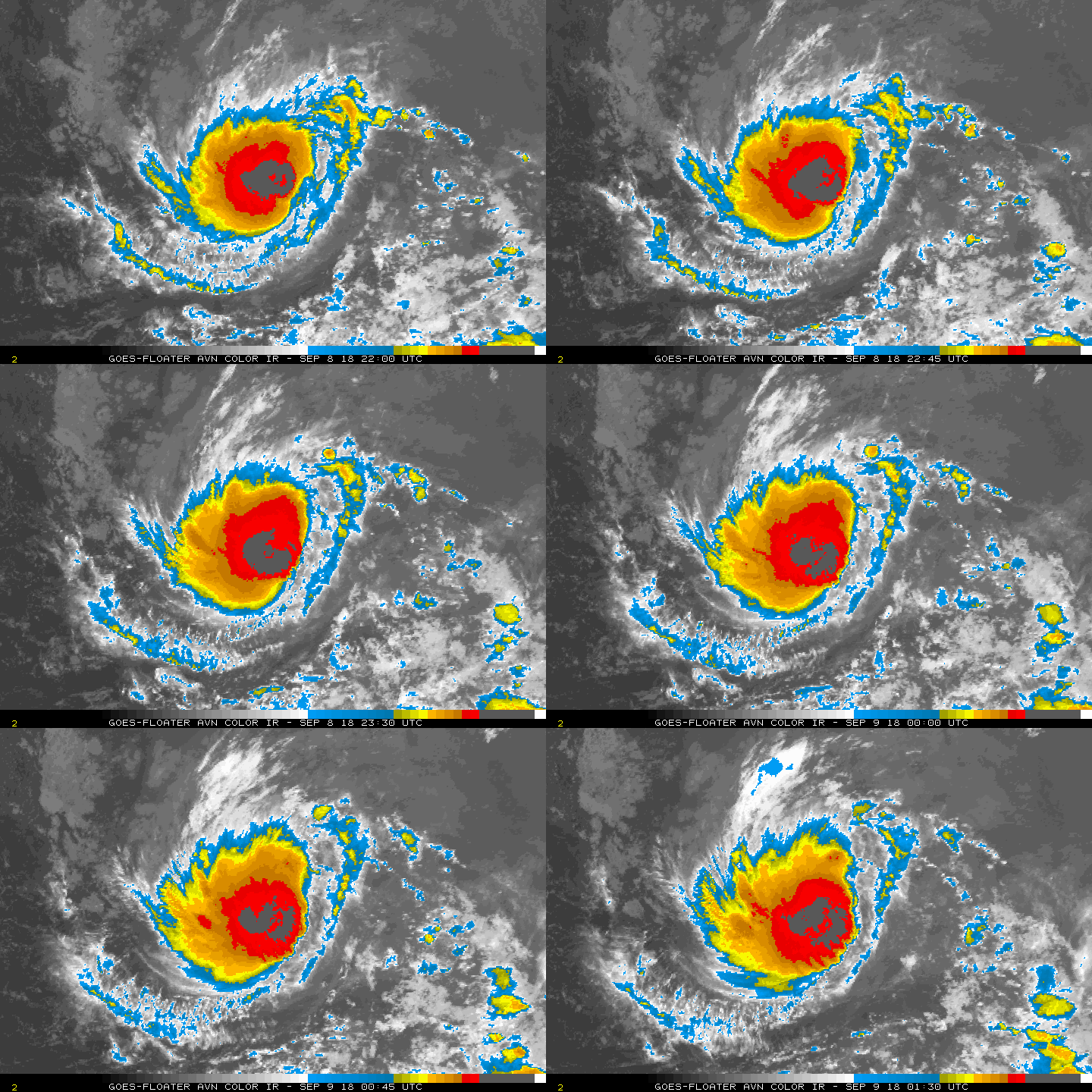
NHC 命名"Isaac",巔峰上望二級颶風。
251
WTNT44 KNHC 090242
TCDAT4

Tropical Storm Isaac Discussion Number   6
NWS National Hurricane Center Miami FL       AL092018
1100 PM AST Sat Sep 08 2018

Isaac is strengthening this evening.  Satellite images indicate that
the deep convection has been increasing in intensity and coverage
with better defined banding features.  The center is not located in
the center of the convection, however, due to some easterly shear.
An ASCAT pass around 00Z showed maximum winds in the 40-45 kt
range.  These data are also in line with the latest Dvorak
classifications of 3.0/45 kt from TAFB and SAB.  Based on these
estimates, the initial intensity is raised to 45 kt.

Isaac will likely continue to strengthen during the next few days as
the storm remains over warm waters and moves into an environment of
decreasing wind shear.  Beyond a few days, the SHIPS model shows a
notable increase in shear, in part due to the outflow from Florence,
which should end the strengthening trend and cause some weakening.
With the exception of the HMON and COAMPS-TC models, the remainder
of the intensity guidance is higher this cycle.  The NHC intensity
forecast is raised from the previous one, but it is a little lower
than the HCCA and IVCN guidance.

The storm is moving due westward at 7 kt.  The track forecast seems
fairly straightforward.  A strengthening subtropical ridge to the
north of the system should cause Isaac to move westward at an
increasing forward speed during the next several days.  This
scenario is supported by the usually more reliable GFS and ECMWF
models, and the NHC track forecast is near a blend of those aids.
Based on the current forecast, Isaac will be near the Lesser
Antilles in 4 to 5 days and interests there should monitor the
progress of this system.

FORECAST POSITIONS AND MAX WINDS

INIT  09/0300Z 14.4N  37.5W   45 KT  50 MPH
12H  09/1200Z 14.4N  38.7W   50 KT  60 MPH
24H  10/0000Z 14.5N  40.9W   60 KT  70 MPH
36H  10/1200Z 14.5N  43.5W   70 KT  80 MPH
48H  11/0000Z 14.5N  46.1W   75 KT  85 MPH
72H  12/0000Z 14.5N  51.5W   85 KT 100 MPH
96H  13/0000Z 14.6N  57.0W   80 KT  90 MPH
120H  14/0000Z 15.0N  62.9W   75 KT  85 MPH

$$
Forecaster Cangialosi
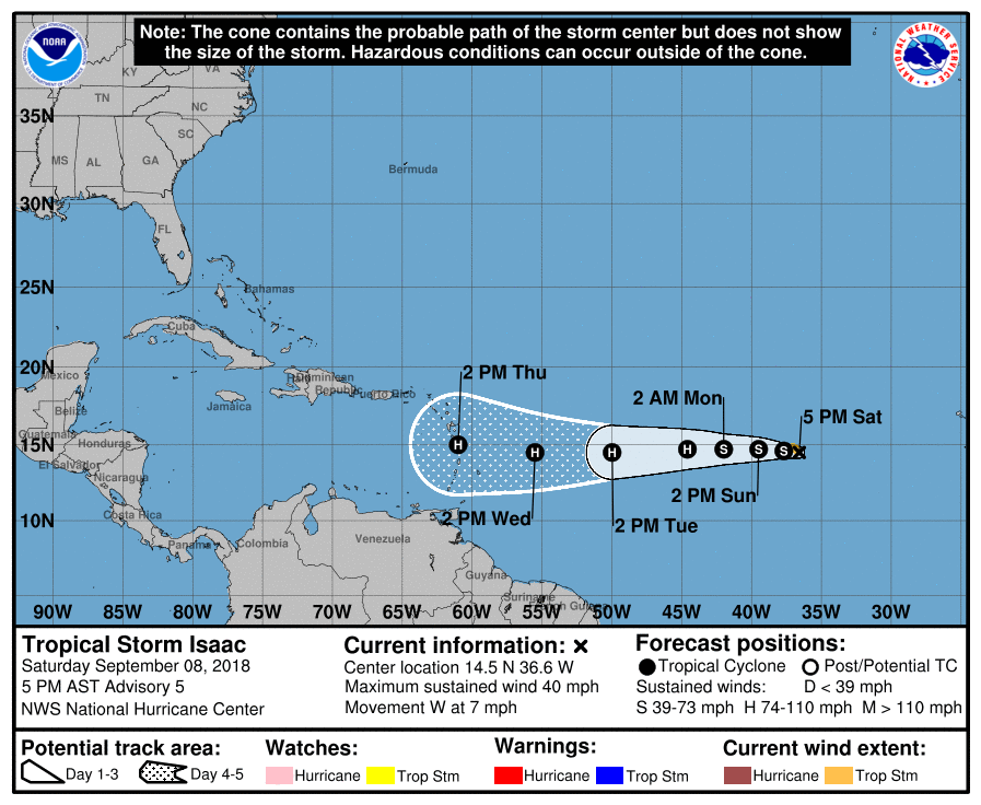
205358_5day_cone_no_line_and_wind.png rgb-animated (1).gif avn-animated (4).gif


點評

上一次的Issac也是09L~  發表於 2018-9-9 10:55

評分

參與人數 1水氣能量 +5 收起 理由
jwpk9899 + 5

查看全部評分

回復

使用道具 舉報

簽到天數: 3291 天

[LV.Master]伴壇終老

t02436|2018-9-18 00:48 | 顯示全部樓層
Isaac巔峰為65節 993百帕,NHC兩天前停止發報。
目前殘餘雲系正通過牙買加南方海域,NHC展望Low,將朝猶加敦半島方向行進,數值看好系統在墨西哥灣會有所發展。
1. A weak area of low pressure, associated with the remnants of Isaac,
is located just south of Jamaica.  Showers and thunderstorms
are currently limited, and any development should be slow to
occur during the next day or so.  By Wednesday, environmental
conditions are forecast to become less conducive for re-development
to occur when the system moves toward the Yucatan Peninsula.
Regardless of development, locally heavy rains and gusty winds are
possible over portions of Hispaniola, Jamaica, and eastern Cuba
during the next couple of days while the system moves westward to
west-northwestward across the northwestern Caribbean Sea.
* Formation chance through 48 hours...low...10 percent.
* Formation chance through 5 days...low...10 percent.

two_atl_5d1.png

09L_tracks_latest.png

09L_intensity_latest.png

GOES16372018260nAWsck.jpg
回復

使用道具 舉報

快速回覆
您需要登錄後才可以回帖 登錄 | 立即加入

本版積分規則

霧峰追風者

    主題

    帖子

    221萬

    積分

    16級[四級颶風]

    Rank: 16Rank: 16Rank: 16Rank: 16

16級[四級颶風]

發訊息

本平台僅供學術討論之用,預報應以氣象局為準

威普網站虛擬主機贊助公司

臺灣第一個天氣類型社群平台 即時天氣資訊、精準颱風動態

線上客服
FB傳送訊息
廣告行銷
精準行銷 物超所值
官方粉專
發佈 快速回復 返回頂部 返回列表