開啟輔助訪問
 找回密碼
 立即加入

06L.Florence 自西非長遠西行 二度上MH 後襲擊美國東岸

簽到天數: 2141 天

[LV.Master]伴壇終老

2018-8-30 17:20 | 顯示全部樓層
  四級颶風  
編號:06 L
名稱:Florence

  基本資料  
擾動編號日期:2018 08 30 17
命名日期  :2018 09 01 17
撤編日期  :2018 09 17 08
登陸地點  :美國 北卡羅萊納州 賴茨維爾海灘

  巔峰時期資料  
近中心最強風速 :120 kt
海平面最低氣壓 :939 百帕

  過去路徑圖  

  擾動編號資料  
90L-INVEST-20kts-1007mb-12.9N-17.0W

79_26427_7efe71bc32513dd.jpg

  NHC:60%  
1. Disorganized showers and thunderstorms moving off the coast ofSenegal are associated with a strong tropical wave and broad areaof low pressure.  A more well-defined low pressure system isforecast to form between Senegal and the Cabo Verde Islands latertoday after the tropical wave moves offshore over the far easternAtlantic Ocean, and the low is likely to become a tropicaldepression by the weekend while moving westward or west-northwestward at about 15 mph.  This system is expected to bringheavy rains and gusty winds to the Cabo Verde Islands on Friday andSaturday, and interests on the islands should monitor the progressof this disturbance.* Formation chance through 48 hours...medium...60 percent.* Formation chance through 5 days...high...80 percent.

79_26427_b00d6e5494990cc.png

以上資料來自:NHC、颱風論壇整理製作

點評

已補圖~  發表於 2018-8-31 09:12
OK...我找圖補@@  發表於 2018-8-30 23:44
還是空的@@.....  發表於 2018-8-30 20:29
請記得補圖喔~!  發表於 2018-8-30 20:24

評分

參與人數 1水氣能量 +15 +1 收起 理由
t02436 + 15 + 1

查看全部評分

回復

使用道具 舉報

簽到天數: 2141 天

[LV.Master]伴壇終老

周子堯@FB|2018-8-30 20:40 | 顯示全部樓層
JTWC:TCFA
WTNT21 KNGU 300600
SUBJ/TROPICAL CYCLONE FORMATION ALERT//
RMKS/
1. FORMATION OF A SIGNIFICANT TROPICAL CYCLONE IS POSSIBLE WITHIN
100 NM EITHER SIDE OF A LINE FROM 14.9N 17.0W TO 13.0N 19.9W
WITHIN THE NEXT 00 TO 24 HOURS. AVAILABLE DATA DOES NOT JUSTIFY
ISSUANCE OF NUMBERED TROPICAL CYCLONE WARNINGS AT THIS TIME.
SURFACE WINDS IN THE AREA ARE ESTIMATED TO BE 15 TO 20 KNOTS.
SATELLITE IMAGERY AT 300600Z INDICATES THAT A TROPICAL WAVE WITH AN
ASSOCIATED AREA OF LOW PRESSURE IS LOCATED NEAR 14.9N 17.0W. THE
SYSTEM IS MOVING WESTWARD AT 16 KNOTS.
2. REMARKS:
AN AREA OF LOW PRESSURE ASSOCIATED WITH A STRONG TROPICAL WAVE IS
LOCATED ABOUT 413 MILES EAST OF THE CABO VERDE ISLANDS. SHOWERS
AND THUNDERSTORMS ASSOCIATED WITH THE LOW PRESSURE SYSTEM
CONTINUE TO BECOME BETTER
ORGANIZED. ENVIRONMENTAL CONDITIONS ARE CONDUCIVE FOR FURTHER
DEVELOPMENT AND THIS SYSTEM IS LIKELY TO BECOME A TROPICAL
CYCLONE TODAY OR TONIGHT AS THE LOW MOVES GENERALLY WESTWARD AND
TOWARD THE CABO VERDE ISLANDS.
79_105412_03f7e4ada7ba9ae.gif


回復

使用道具 舉報

簽到天數: 3291 天

[LV.Master]伴壇終老

t02436|2018-8-30 23:45 | 顯示全部樓層

NHC升格潛在熱帶氣旋06L,暫時上望65節。
882
WTNT41 KNHC 301444
TCDAT1

Potential Tropical Cyclone Six Discussion Number   1
NWS National Hurricane Center Miami FL       AL062018
1100 AM AST Thu Aug 30 2018

The area of low pressure that moved off the coast of Africa has
continued to become better organized, and is producing a large
area of disturbed weather with gusty winds, but currently lacks a
well-defined center.  Environmental conditions are favorable for
additional development, and a tropical depression or a tropical
storm could form an any time today or Friday.  Given the high
chances that this system could bring tropical storm conditions to a
portion of the southern Cabo Verde Islands, advisories have been
initiated on Potential Tropical Cyclone Six.  Most of the intensity
guidance calls for strengthening and so does the NHC forecast.

The system is embedded within the easterly trades and this flow
pattern will steer the disturbance toward the west or west-
northwest during the next few days.  By the end of the forecast
period, a turn toward the northwest should begin as the system
reaches a weakness in the subtropical high.  This is consistent with
the output of the global models.

FORECAST POSITIONS AND MAX WINDS

INIT  30/1500Z 12.9N  18.4W   25 KT  30 MPH...POTENTIAL TROP CYCLONE
12H  31/0000Z 13.2N  20.1W   30 KT  35 MPH...TROPICAL DEPRESSION
24H  31/1200Z 13.5N  22.0W   35 KT  40 MPH
36H  01/0000Z 14.0N  24.0W   45 KT  50 MPH
48H  01/1200Z 15.0N  27.0W   55 KT  65 MPH
72H  02/1200Z 16.5N  33.0W   65 KT  75 MPH
96H  03/1200Z 18.5N  38.0W   65 KT  75 MPH
120H  04/1200Z 20.0N  42.0W   65 KT  75 MPH

$$
Forecaster Avila

144600_5day_cone_with_line.png

GOES15302018242jU4xjY.jpg
回復

使用道具 舉報

簽到天數: 3291 天

[LV.Master]伴壇終老

t02436|2018-9-1 16:58 | 顯示全部樓層
命名Florence,巔峰上望60節。
081
WTNT41 KNHC 010856
TCDAT1

Tropical Storm Florence Discussion Number   8
NWS National Hurricane Center Miami FL       AL062018
500 AM AST Sat Sep 01 2018

A recent SSMIS microwave pass has revealed that the cyclone has
become much better organized with more pronounced convective
banding.  Satellite intensity estimates are wide ranging, spanning
from T1.5/25 kt from SAB to T3.4/53 kt from the UW-CIMSS ADT.  Since
the numbers overall have increased, and the structure has improved,
the initial intensity is raised to 35 kt, in closest agreement to
the TAFB estimate, but this could be conservative.  This makes the
depression Tropical Storm Florence, the sixth named storm of the
season.

Florence is moving west-northwestward, or 285/12 kt, and should
maintain this motion for the next 48 hours while traveling along the
southern periphery of the subtropical ridge.  After 48 hours, the
storm is expected to reach a break in the ridge, causing it to slow
down and turn northwestward by day 5.  The biggest change noted
among the track models on this cycle was a westward shift in the
overall guidance envelope.  The European model, in particular, swung
significantly to the left, showing a weaker Florence not feeling the
break in the ridge quite as much.  I'd like to see this trend
continue before making a significant change to the forecast, so for
now the updated NHC track prediction is only nudged westward. That
said, the models appear to be trending away from a definitive
recurvature scenario.

The environment is mixed with positives and negatives for Florence's
strengthening.  For the first 3 days, vertical shear over Florence
should be quite low, but the cyclone will also be moving through a
less-than-ideal thermodynamic environment with marginal sea surface
temperatures and decreasing mid-level moisture.  After 3 days, the
thermodynamic environment should begin to improve, but then the
shear is forecast to strengthen. These conflicting signals point to
only gradual strengthening, and the suite of intensity models aren't
too far off from one another, nor from the previous NHC forecast.
For that reason, no significant changes were made in this forecast
package.

FORECAST POSITIONS AND MAX WINDS

INIT  01/0900Z 14.5N  26.7W   35 KT  40 MPH
12H  01/1800Z 15.0N  28.7W   40 KT  45 MPH
24H  02/0600Z 15.7N  31.2W   45 KT  50 MPH
36H  02/1800Z 16.4N  33.7W   50 KT  60 MPH
48H  03/0600Z 17.1N  36.3W   55 KT  65 MPH
72H  04/0600Z 18.7N  41.4W   60 KT  70 MPH
96H  05/0600Z 21.0N  45.5W   60 KT  70 MPH
120H  06/0600Z 23.5N  48.5W   55 KT  65 MPH

$$
Forecaster Berg

085655_5day_cone_with_line.png

20180901.0800.msg-4.ircolor.06L.SIX.35kts.1003mb.14.3N.26.1W.100pc.jpg
回復

使用道具 舉報

簽到天數: 3291 天

[LV.Master]伴壇終老

t02436|2018-9-4 23:08 | 顯示全部樓層
15Z升C1,是大西洋今年第三個颶風
386
WTNT41 KNHC 041437
TCDAT1

Hurricane Florence Discussion Number  21
NWS National Hurricane Center Miami FL       AL062018
1100 AM AST Tue Sep 04 2018

Florence's structure has gradually increased in organization, with
SSMIS passes from a few hours ago revealing the development of a
mid-level microwave eye.  Dvorak estimates have responded in
kind--TAFB is up to T4.0, SAB is at T4.5, and the objective ADT is
in between at T4.4.  Since there still appears to be moderate
southwesterly shear inducing some tilt to the cyclone and
disrupting the infrared satellite pattern, the initial intensity is
raised conservatively to 65 kt, making Florence a hurricane.

The current motion remains west-northwestward, or 295/10 kt, with
Florence positioned near the southwestern edge of the subtropical
ridge.  The steering pattern ahead of Florence is rather complicated
and will be evolving over the next few days.  A large and complex
mid-/upper-level trough located northeast of the Leeward Islands is
expected to give way to the development of two upper-level highs
centered near the Greater Antilles and southwest of the Azores, with
Florence slowing down and turning northwestward between these new
features.  Despite this complex pattern, the spread in the track
models is less than normal, which increases the confidence in the
NHC track forecast for the next 5 days.  There is some spread which
begins to develop around day 5, with the ECMWF model moving Florence
a little faster toward the north while the GFS maintains a slower
speed and keeps the system to the south.  The updated NHC track
forecast has been nudged slightly to the east of the previous
forecast on days 4 and 5, close to the TVCX consensus but not as far
as the HCCA and ECMWF models.  There is still too much model spread
after day 5 to speculate what Florence might do beyond the official
forecast period.

Despite Florence becoming a hurricane, the southwesterly shear
affecting the cyclone is expected to increase over the next day or
two, which should prevent further intensification.  In fact, the
increasing shear, as well as mid-level relative humidities below 50
percent, should cause weakening between 24 and 72 hours.  After 72
hours, decreasing shear and warmer sea surface temperatures should
foster some re-intensification, with Florence expected to reattain
hurricane intensity by day 5.  The intensity guidance is in good
agreement, and the NHC forecast is very close to a blend of HCCA,
the Florida State Superensemble, and the ICON consensus.

FORECAST POSITIONS AND MAX WINDS

INIT  04/1500Z 19.7N  42.5W   65 KT  75 MPH
12H  05/0000Z 20.3N  44.0W   65 KT  75 MPH
24H  05/1200Z 21.3N  46.2W   65 KT  75 MPH
36H  06/0000Z 22.4N  48.2W   60 KT  70 MPH
48H  06/1200Z 23.6N  50.0W   55 KT  65 MPH
72H  07/1200Z 25.6N  52.7W   50 KT  60 MPH
96H  08/1200Z 27.5N  55.0W   55 KT  65 MPH
120H  09/1200Z 29.5N  56.5W   65 KT  75 MPH

$$
Forecaster Berg

143848_5day_cone_with_line.png

LATEST.jpg

goes16_truecolor_06L_201809041435.jpg

goes16_ir_06L_201809041435.jpg
回復

使用道具 舉報

簽到天數: 3291 天

[LV.Master]伴壇終老

t02436|2018-9-5 15:11 | 顯示全部樓層
原本不怎麼看好發展,但03Z評價85節,06Z速報評價90節,站上C2。
797
WTNT41 KNHC 050252
TCDAT1

Hurricane Florence Discussion Number  23
NWS National Hurricane Center Miami FL       AL062018
1100 PM AST Tue Sep 04 2018

GOES-16 imagery shows that the eye of Florence has become better
defined during the last several hours, with even some mesovortices
in the eye present on the shortwave infrared channel.  Satellite
intensity estimates continue to rise, and the initial wind speed is
set to 85 kt, just below the latest TAFB estimate of 90 kt.

Florence remains on a west-northwestward course at 300/10 kt.  This
general course is expected to continue through 36 or 48 hours while
the hurricane remains near the southwestern edge of the subtropical
ridge.  After that time, the forecast becomes more uncertain,
depending on the presence of a narrow mid-level ridge over the
north-central Atlantic Ocean.  A look at the ensemble guidance
shows a bifurcation developing by day 5, with the ECMWF favoring
a more northward turn, and the UKMET ensembles showing a stronger
ridge and a continuation of a west-northwest track.  The new NHC
forecast is adjusted westward at long range, in line with the
corrected-consensus aids, but don't be surprised if this forecast
undergoes some large changes in the next few cycles, given the
split in the guidance.

This intensity forecast is also difficult.   Florence certainly has
exceeded expectations during the last day or so, with the hurricane
on the verge of rapidly intensifying during the last 24 hours
despite a marginal environment.  Some more strengthening is
called for in the short term to reflect the current trend.
However, the global models continue to insist that southwesterly
shear will increase over the next couple of days which, in
combination with considerable dry air aloft, should cause some
weakening.  Later tomorrow, a slow weakening trend should begin and
continue through 48 hours, although not weakening as much as shown
in the past advisory.  This can't be considered a high-confidence
prediction in light of what Florence has done so far.  On Friday, an
upper-level low could cut off to the south of the cyclone, which
would lessen the shear near Florence, and the hurricane should be
moving over steadily increasing SSTs. Restrengthening is forecast at
long range, and it wouldn't be surprising if the new NHC prediction
turns out to be too low.  It is best to be conservative, however,
since the track uncertainty is increasing by the end of the
forecast.


FORECAST POSITIONS AND MAX WINDS

INIT  05/0300Z 20.7N  43.9W   85 KT 100 MPH
12H  05/1200Z 21.5N  45.5W   90 KT 105 MPH
24H  06/0000Z 22.6N  47.6W   80 KT  90 MPH
36H  06/1200Z 23.7N  49.4W   70 KT  80 MPH
48H  07/0000Z 24.7N  50.9W   65 KT  75 MPH
72H  08/0000Z 26.0N  53.5W   65 KT  75 MPH
96H  09/0000Z 27.3N  55.8W   70 KT  80 MPH
120H  10/0000Z 29.0N  57.5W   80 KT  90 MPH

$$
Forecaster Blake
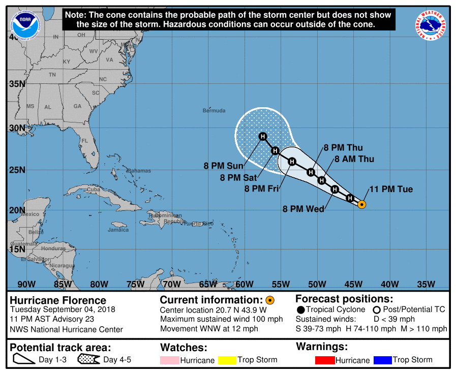
025341_5day_cone_with_line.png

AL, 06, 2018090506,   , BEST,   0, 211N,  443W,  90,  976, HU,
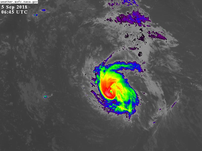
GOES06452018248jcNesi.jpg
回復

使用道具 舉報

簽到天數: 601 天

[LV.9]以壇為家II

霧峰追風者|2018-9-5 21:51 | 顯示全部樓層
12Z 強度升MH。 20180905.1300.msg-4.ir.06L.FLORENCE.105kts.961mb.21.7N.45.2W.100pc.jpg 20180905.1119.noaa18.89rgb.06L.FLORENCE.105kts.961mb.21.7N.45.2W.100pc.jpg

回復

使用道具 舉報

簽到天數: 3291 天

[LV.Master]伴壇終老

t02436|2018-9-5 23:06 | 顯示全部樓層
完全超乎預期的發展,15Z已經取得110節的評價。
150
WTNT41 KNHC 051440
TCDAT1

Hurricane Florence Discussion Number  25
NWS National Hurricane Center Miami FL       AL062018
1100 AM AST Wed Sep 05 2018

Remarkably, Florence has continued to strengthen.  The hurricane
has a compact central dense overcast with cold cloud tops completely
encircling a clear, well-defined eye.  With the improved structure,
subjective Dvorak estimates have increased to T5.5/102 kt from TAFB
and T6.0/115 kt from SAB, while the latest objective UW-CIMSS ADT
estimate is T5.8/110 kt.  The initial intensity is therefore set at
110 kt as a blend of these numbers, with Florence having become a
major hurricane earlier this morning.

Given the estimated maximum winds, Florence has been rapidly
intensifying since yesterday, an event that was not foreseen by any
intensity models, nor forecasters.  Diagnostics from the SHIPS
model and UW-CIMSS shear analyses have been consistently showing
southwesterly shear of 20-25 kt in the vicinity of Florence, but it
is possible that those schemes are averaging over a larger area
than might be reasonable given the hurricane's small size.  Florence
has apparently been able to find a small pocket of relatively low
shear, and with waters becoming progressively warmer, the hurricane
has strengthened significantly more than anticipated.  This makes
the intensity forecast incredibly uncertain.  SHIPS actually shows
the shear increasing over the next 24 hours, but global model
fields suggest that the hurricane may still be able to continue
within the protected pocket of lower shear for the next several
days.  As a result, the NHC official forecast keeps Florence's
intensity well above the available guidance, which all show the
hurricane weakening over the next day or two.  The new NHC
prediction follows this trend and also shows some weakening, but
this is a low-confidence forecast.  Either way, Florence is
expected to remain a hurricane throughout the 5-day period.

The track forecast also has its challenges.  The initial motion
estimate is northwestward, or 305/11 kt.  It now appears that
stronger upper-level ridging may take shape to the north of
Florence over the next few days, forcing the hurricane to turn back
toward the west-northwest from 36-72 hours.  After 72 hours, a
break in the ridge should allow Florence to turn back toward the
northwest, but the bulk of the track models have trended westward
since yesterday.  In light of these trends, the NHC official track
forecast has been shifted westward on days 4 and 5, but not quite
as far as the various model consensus aids.  It is worth stressing
that there is still a significant amount of spread among the GFS
and ECMWF ensemble members by the end of the forecast period, and
just like the intensity forecast, the track forecast is of low
confidence.


FORECAST POSITIONS AND MAX WINDS

INIT  05/1500Z 22.0N  45.7W  110 KT 125 MPH
12H  06/0000Z 22.7N  47.2W  110 KT 125 MPH
24H  06/1200Z 23.8N  49.0W  100 KT 115 MPH
36H  07/0000Z 24.7N  50.6W   95 KT 110 MPH
48H  07/1200Z 25.1N  52.1W   90 KT 105 MPH
72H  08/1200Z 25.7N  54.7W   90 KT 105 MPH
96H  09/1200Z 27.0N  57.0W   95 KT 110 MPH
120H  10/1200Z 28.5N  59.0W   95 KT 110 MPH

$$
Forecaster Berg/Rhome

144103_5day_cone_with_line.png

LATEST.jpg

goes16_truecolor_06L_201809051450.jpg

goes16_ir_06L_201809051450.jpg

GOES14452018248QxHuQA.jpg
回復

使用道具 舉報

123下一頁
快速回覆
您需要登錄後才可以回帖 登錄 | 立即加入

本版積分規則

周子堯@FB

    主題

    帖子

    94萬

    積分

    13級[一級颶風]

    Rank: 13Rank: 13Rank: 13Rank: 13

13級[一級颶風]

發訊息

本平台僅供學術討論之用,預報應以氣象局為準

威普網站虛擬主機贊助公司

臺灣第一個天氣類型社群平台 即時天氣資訊、精準颱風動態

線上客服
FB傳送訊息
廣告行銷
精準行銷 物超所值
官方粉專
發佈 快速回復 返回頂部 返回列表