開啟輔助訪問
 找回密碼
 立即加入

14E.Lane 實測猛爆上C5 中太12年最強颶風

簽到天數: 2414 天

[LV.Master]伴壇終老

2018-8-11 21:18 | 顯示全部樓層
  五級颶風  
編號:14 E
名稱:Lane

  基本資料  
擾動編號日期:2018 08 11 21
命名日期  :2018 08 15 23
       2018 08 19 11 - CPHC接續發報
撤編日期  :2018 08 29 04
登陸地點  :

  巔峰時期資料  
近中心最強風速
國家颶風中心(NHC):120 kt
中太平洋颶風中心 ( CPHC ):140 kt
海平面最低氣壓922 百帕

  過去路徑圖  


  擾動編號資料  
97E.INVEST.25kts.1006mb.8.5N.105W

20180811.1300.goes-15.ircolor.97E.INVEST.25kts.1006mb.8.5N.105W.080pc.jpg

  NHC:10%  
1. A concentrated area of showers and thunderstorms centered a little
more than 600 miles south of Manzanillo, Mexico is associated with
a tropical wave. This activity has become a little better organized
since yesterday, and conditions appear to be favorable for some
development of this system by the middle of next week while the
disturbance moves westward away from the coast of Mexico.
* Formation chance through 48 hours...low...near 10 percent.
* Formation chance through 5 days...low...30 percent.

two_pac_2d1.png

以上資料來自:NHC、CPHC颱風論壇整理製作

評分

參與人數 1水氣能量 +15 +1 收起 理由
king111807 + 15 + 1 熱帶擾動首帖

查看全部評分

回復

使用道具 舉報

簽到天數: 601 天

[LV.9]以壇為家II

霧峰追風者|2018-8-14 14:55 | 顯示全部樓層
JTWC 06Z發布TCFA,NHC 展望提升至60%,穩定西移,後期有機會進入中太。
1. A large low pressure system is located about 950 miles southwest of
the southern tip of the Baja California peninsula. Shower and
thunderstorm activity continues to become better organized, and
environmental conditions are expected to be conducive for a tropical
depression to form during the next couple of days days while the
disturbance moves westward at 10 to 15 mph.
* Formation chance through 48 hours...medium...60 percent.
* Formation chance through 5 days...high...90 percent.
two_pac_2d1.png ep972018.20180814061531.gif 20180814.0630.goes-15.ir.97E.INVEST.25kts.1009mb.11.5N.118.3W.100pc.jpg 97E_gefs_latest.png 97E_intensity_latest.png

回復

使用道具 舉報

簽到天數: 601 天

[LV.9]以壇為家II

霧峰追風者|2018-8-15 03:14 | 顯示全部樓層
NHC 展望提升至80%,穩定西行。
1. A well-defined low pressure system is located just over 1000 miles
southwest of the southern tip of the Baja California peninsula.
Showers and thunderstorms continue to become better organized, and a
tropical depression is likely to form tonight or Wednesday while the
disturbance moves westward at 10 to 15 mph.
* Formation chance through 48 hours...high...80 percent.
* Formation chance through 5 days...high...90 percent.

two_pac_2d1.png 20180814.1414.f18.ir.olsircomp.97E.INVEST.x.jpg rgb_lalo-animated.gif
回復

使用道具 舉報

簽到天數: 601 天

[LV.9]以壇為家II

霧峰追風者|2018-8-15 11:45 | 顯示全部樓層
NHC 升格熱帶低壓14E,預測進入中太達二級颶風。
191
WTPZ44 KNHC 150238
TCDEP4

Tropical Depression Fourteen-E Discussion Number   1
NWS National Hurricane Center Miami FL       EP142018
800 PM PDT Tue Aug 14 2018

The area of disturbed weather and associated low pressure area that
the NHC has been tracking for the past few days has acquired enough
organized deep convection for the system to be declared a tropical
depression. Although the convection had waned a little during the
day, recent satellite imagery indicates that convection near the
well-defined center has begun to increase and that outer banding
features in the western semicircle have been improving during the
past few hours. The initial intensity of 30 kt is based on a Dvorak
satellite intensity estimate of T2.0/30 kt from TAFB.

The initial motion estimate is 265/12 kt. For the next 72 hours, the
tropical cyclone is forecast to move westward or slightly south of
due west along the southern periphery of a broad deep-layer ridge
that is located to the north of the depression. The ridge is
expected to weaken by 96 hours as a mid-latitude low/trough
currently located off the coast of southern California digs
southward and then westward during the forecast period. This
pattern should allow the cyclone to move west-northward into the
weakness in the ridge and start gaining latitude. For this initial
forecast of the system, the NHC track lies close to a blend of the
consensus track models HCCA and TVCE.

The vertical wind shear is forecast to remain around 10 kt or less
for the next 72 hours or so, with a further decrease on days 4 and 5
when the system moves underneath and/or develops an upper-level
anticyclone, conditions that typically favor significant
intensification. However, since the circulation envelope is
currently elongated northeast-to-southwest, it will take a couple of
days for the system to become more symmetrical, which could then
enhance the strengthening process. By that time, however, sea-
surface temperatures and mid-level humidity values will be marginal
for significant intensification to occur. As a result, only slow but
steady strengthening is indicated in this first intensity forecast,
which closely follows the HCCA intensity consensus model.

FORECAST POSITIONS AND MAX WINDS

INIT  15/0300Z 10.9N 121.2W   30 KT  35 MPH
12H  15/1200Z 10.8N 122.9W   35 KT  40 MPH
24H  16/0000Z 10.7N 125.2W   40 KT  45 MPH
36H  16/1200Z 10.8N 127.3W   45 KT  50 MPH
48H  17/0000Z 11.0N 129.5W   50 KT  60 MPH
72H  18/0000Z 12.0N 134.1W   65 KT  75 MPH
96H  19/0000Z 13.8N 138.6W   80 KT  90 MPH
120H  20/0000Z 15.6N 142.8W   90 KT 105 MPH

$$
Forecaster Stewart

024005_5day_cone_no_line_and_wind.png 20180815.0300.goes-15.ir.14E.FOURTEEN.30kts.1008mb.11N.120.6W.100pc.jpg avn-animated (4).gif


點評

有機會到西太平洋嗎?  詳情 回復 發表於 2018-8-15 19:42
回復

使用道具 舉報

簽到天數: 35 天

[LV.5]常住居民I

傳奇@天氣人|2018-8-15 19:42 來自手機 | 顯示全部樓層
霧峰追風者 發表於 2018-8-15 11:45
NHC 升格熱帶低壓14E,預測進入中太達二級颶風。

有機會到西太平洋嗎?

點評

現在來看可能進入西太前就GG了  發表於 2018-8-19 13:36
看數值15天後有機會進入西太,不過變動性很大。  發表於 2018-8-16 10:48
字數未滿20字請善用點評功能唷,手機板的可用chrome瀏覽器跳電腦版就能點評囉  發表於 2018-8-16 01:13
現在還太早,變數很大。  發表於 2018-8-15 22:36
回復

使用道具 舉報

簽到天數: 3291 天

[LV.Master]伴壇終老

t02436|2018-8-15 23:48 | 顯示全部樓層
15Z命名Lane,暫時上望105節。
781
WTPZ44 KNHC 151452
TCDEP4

Tropical Storm Lane Discussion Number   3
NWS National Hurricane Center Miami FL       EP142018
800 AM PDT Wed Aug 15 2018

The latest satellite imagery shows that the cyclone continues to
become better organized with a growing central dense overcast along
with ample banding features.  Dvorak estimates range from 30 to 40
kt, and with the increased organization since the last advisory,
the initial wind speed is set to 35 kt.

Further intensification is likely over the next few days as Lane
encounters a conducive large-scale environment consisting of low
shear and fairly warm waters.  Rapid strengthening is a distinct
possibility after the cyclone forms an inner core, which could take
a day or so given that there is still some drier air in the eastern
semicircle.  The DTOPS rapid intensification index indicates a high
probability of significant strengthening over the next 3 days, with
over a 70 percent chance of a 65-kt increase during that time.
Given that some of the guidance (FSSE and HMON) are even higher than
that, this seems like a reasonable forecast and is indicated below.
The new NHC forecast is raised from the last advisory, and is close
to a blend of the previous forecast and the corrected-consensus
guidance.  Continuity prevents a higher forecast, but Lane seems
destined to eventually become a category-4 hurricane like Hector.

The storm continues to move just south of due west at about 12 kt.
The subtropical ridge to the north of Lane is forecast to weaken
slightly over the next few days, which will likely steer the cyclone
to the west or west-northwest throughout the period.  There is very
little spread in the guidance, with the most notable change since
the last advisory being a small shift to the southwest.  The
latest official track forecast is adjusted in that direction, and is
not too far from the latest model consensus.  Given the tightly
packed guidance, this appears to be a high-confidence forecast.


FORECAST POSITIONS AND MAX WINDS

INIT  15/1500Z 10.7N 123.6W   35 KT  40 MPH
12H  16/0000Z 10.6N 125.5W   45 KT  50 MPH
24H  16/1200Z 10.7N 127.7W   55 KT  65 MPH
36H  17/0000Z 11.0N 130.0W   70 KT  80 MPH
48H  17/1200Z 11.5N 132.4W   85 KT 100 MPH
72H  18/1200Z 12.6N 137.6W  100 KT 115 MPH
96H  19/1200Z 13.9N 142.2W  105 KT 120 MPH
120H  20/1200Z 15.0N 146.5W  105 KT 120 MPH

$$
Forecaster Blake

145223_5day_cone_with_line.png

GOES15002018227ZGaIB3.jpg
回復

使用道具 舉報

簽到天數: 3291 天

[LV.Master]伴壇終老

t02436|2018-8-19 01:14 | 顯示全部樓層
已站上C4,00Z進中太。
974
WTPZ44 KNHC 181451
TCDEP4

Hurricane Lane Discussion Number  15
NWS National Hurricane Center Miami FL       EP142018
800 AM PDT Sat Aug 18 2018

Lane's inner-core convective organization has continued to improve
with satellite intensity estimates vacillating between T6.0/115 kt
and T6.5/127 kt during the past 6 hours. The 15-nmi-diameter eye
remains quiet distinct and is embedded within a solid ring of cloud
tops colder than -70 deg C. An average of the various intensity
estimates from TAFB, SAB, and UW-CIMSS ADT and SATCON support
increasing the intensity to 120 kt.

The initial motion estimate is 285/13 kt. There has been little
change in the models over the past couple of days, and the latest
NHC guidance, especially the consensus track models, required no
significant changes to the previous advisory track. The large
expansive subtropical ridge to the north of the hurricane is
forecast to remain intact and gradually build westward to the north
of the Hawaiian Islands throughout the 120-h forecast period. As a
result, Lane is expected to move west-northwestward for the next 48
hours or so, and then turn westward by day 3, maintaining that
motion on days 4 and 5. The official forecast track lies close to a
blend of the HCCA, TVCE, and FSSE consensus models. On the forecast
track, Hurricane Lane is expected to move into the Central Pacific
basin in about 9 hours at around 0000 UTC.

Although Lane will be remaining over 27.0-27.5 deg C SSTs during
the forecast period, increasing westerly to northwesterly vertical
wind shear to around 15 kt, along with a slightly drier mid-level
environment, is expected to induce slow but steady weakening by 24
hours. Although Lane could strengthen a little more before the
prolonged weakening begins, the general intensity trend should be
downward. However, the rate of weakening is held a little above the
intensity guidance owing to the warmer SSTs indicated by raw data
than what the SHIPS model guidance is using.

FORECAST POSITIONS AND MAX WINDS

INIT  18/1500Z 12.3N 138.2W  120 KT 140 MPH
12H  19/0000Z 12.8N 140.0W  120 KT 140 MPH
24H  19/1200Z 13.4N 142.3W  115 KT 130 MPH
36H  20/0000Z 13.8N 144.3W  110 KT 125 MPH
48H  20/1200Z 14.1N 146.3W  105 KT 120 MPH
72H  21/1200Z 14.5N 150.1W   95 KT 110 MPH
96H  22/1200Z 14.9N 153.5W   80 KT  90 MPH
120H  23/1200Z 15.8N 157.0W   65 KT  75 MPH

$$
Forecaster Stewart

145316_5day_cone_with_line.png

GOES15002018230YxjfuY.jpg
回復

使用道具 舉報

簽到天數: 3291 天

[LV.Master]伴壇終老

t02436|2018-8-19 14:02 | 顯示全部樓層
進入中太,CPHC第一報給115節。
WTPA42 PHFO 190247
TCDCP2

Hurricane Lane Discussion Number  17
NWS Central Pacific Hurricane Center Honolulu HI   EP142018
500 PM HST Sat Aug 18 2018

Lane's satellite presentation has degraded a bit over the past few
hours, with the eye clouding over and cooling. The central
convective ring has become a bit asymmetric, becoming elongated
east-to west roughly along the axis of 15 to 18 kt vertical shear.
Outflow seems more favorable now to the east-northeast than 6 to 12
hours ago. Nevertheless, Lane remains a powerful hurricane, with
objective Dvorak Current Intensity (CI) numbers between 6.0/115 kt
(JTWC/SAB) and 6.5/127 kt (PHFO). ADT from UW-CIMSS is weaker at
5.0/105 kt. The initial intensity is set at 115 kt for this
advisory, based on a mix of these estimates.

Lane continues moving toward the west-northwest at about 14 kt,
representing a slight increase in forward speed. This system
should continue on this track through 24 hours, driven by a large
subtropical ridge to its north. As the ridge builds westward, Lane
should shift to a more westerly track from 24 through 72 hours. A
shift back toward the west-northwest should occur from 96 through
120 hours as Lane approaches the western portion of the ridge.
Track guidance remains rather tight, depicting a gradual decrease
in forward speed through the forecast period. The first few
forecast points were pushed forward slightly to account for the
small bump in initial forward speed, but the overall forecast track
closely resembles the previous one, neatly following TVCE consensus.

The intensity forecast roughly follows IVCN consensus guidance,
depicting a gradual weakening through 120 hours. SSTs will remain
in the 27 to 28 degree C range, but with 10 to 15 kt of vertical
shear expected through the forecast period, a forecast for gradual
weakening seems sound.

Lane is forecast to pass south of the main Hawaiian Islands
Wednesday and Thursday, potentially causing local impacts as it
tracks west northwestward. Interests in those islands should watch
the progress of Lane closely, since day 4 and 5 forecast track
errors can be large.


FORECAST POSITIONS AND MAX WINDS

INIT  19/0300Z 12.8N 141.0W  115 KT 130 MPH
12H  19/1200Z 13.2N 143.0W  105 KT 120 MPH
24H  20/0000Z 13.5N 145.2W  100 KT 115 MPH
36H  20/1200Z 13.7N 147.1W   95 KT 110 MPH
48H  21/0000Z 13.9N 148.9W   90 KT 105 MPH
72H  22/0000Z 14.2N 152.2W   80 KT  90 MPH
96H  23/0000Z 15.0N 155.7W   65 KT  75 MPH
120H  24/0000Z 16.2N 159.2W   55 KT  65 MPH

$$
Forecaster Powell
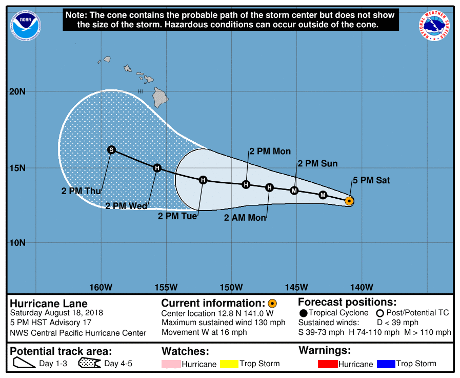
EP142018_5day_cone_with_line_17.png

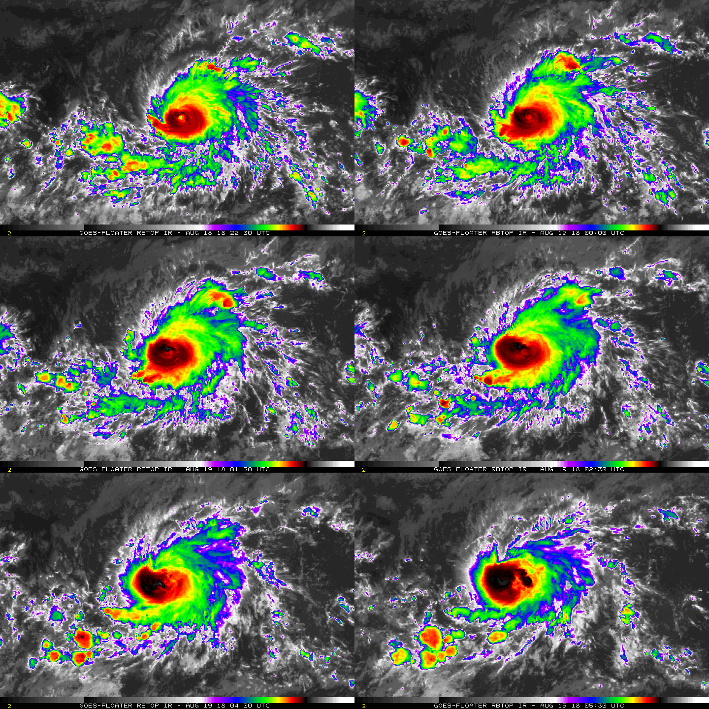
rbtop-animated.gif

點評

有機會可以前進西太  詳情 回復 發表於 2018-8-19 15:45
回復

使用道具 舉報

123下一頁
快速回覆
您需要登錄後才可以回帖 登錄 | 立即加入

本版積分規則

0908morakot

    主題

    帖子

    69萬

    積分

    12級[颶風Hurricane]

    Rank: 12Rank: 12Rank: 12

12級[颶風Hurricane]

發訊息

本平台僅供學術討論之用,預報應以氣象局為準

威普網站虛擬主機贊助公司

臺灣第一個天氣類型社群平台 即時天氣資訊、精準颱風動態

線上客服
FB傳送訊息
廣告行銷
精準行銷 物超所值
官方粉專
發佈 快速回復 返回頂部 返回列表