開啟輔助訪問
 找回密碼
 立即加入

13E.Kristy 締造東太三旋共舞

簽到天數: 601 天

[LV.9]以壇為家II

2018-8-4 02:01 | 顯示全部樓層
  熱帶風暴  
編號:13 E
名稱:Kristy

  基本資料  
擾動編號日期:2018 08 04 01
命名日期  :2018 08 07 17
撤編日期  :2018 08 00 00
登陸地點  :

  巔峰時期資料  
近中心最強風速
國家颶風中心(NHC):60 kts
海平面最低氣壓991 百帕

  過去路徑圖  


  擾動編號資料  
94E.INVEST.20kts-1008mb-12.9N-112.5W

20180803.1730.goes-15.ir.94E.INVEST.20kts.1008mb.12.9N.112.5W.100pc (1).jpg

NHC : 50%
1. Satellite images indicate that a low pressure area has formed about
700 miles southwest of Manzanillo, Mexico, and is already showing
some signs of organization.  Environmental conditions appear
conducive for further development, and a tropical depression is
likely to form over the weekend or early next week.  The low is
forecast to move slowly westward over the next few days.
* Formation chance through 48 hours...medium...50 percent.
* Formation chance through 5 days...high...70 percent.

two_pac_2d1 (1).png

以上資料來自:NHC颱風論壇整理製作

評分

參與人數 1水氣能量 +15 +1 收起 理由
king111807 + 15 + 1 熱帶擾動首帖

查看全部評分

回復

使用道具 舉報

簽到天數: 601 天

[LV.9]以壇為家II

霧峰追風者|2018-8-4 10:06 | 顯示全部樓層
JTWC 00Z發布TCFA,逐漸增強。 ep942018.20180804013528.gif 20180804.0131.goes-15.ircolor.94E.INVEST.25kts.1007mb.13.2N.114.5W.100pc.jpg 94E_gefs_latest.png 94E_intensity_latest.png

回復

使用道具 舉報

簽到天數: 601 天

[LV.9]以壇為家II

霧峰追風者|2018-8-5 01:46 | 顯示全部樓層
NHC 展望提升至70%
1. Showers and thunderstorms associated with an area of low
pressure centered about 825 miles south-southwest of the southern
tip of the Baja California peninsula continue to show signs of
organization. Environmental conditions are likely to support
additional development, and a tropical depression is expected to
form by early next week as the system moves slowly westward.
* Formation chance through 48 hours...high...70 percent.
* Formation chance through 5 days...high...90 percent.
two_pac_2d1 (2).png 20180804.1415.f17.ir.olsircomp.94E.INVEST.x.jpg 94E_gefs_latest (1).png

回復

使用道具 舉報

簽到天數: 601 天

[LV.9]以壇為家II

霧峰追風者|2018-8-6 11:23 | 顯示全部樓層
NHC 展望降低至60%
1. An area of low pressure located about 950 miles southwest of the
southern tip of the Baja California peninsula remains elongated but
is producing a large area of disorganized showers and thunderstorms.
Environmental conditions still appear conducive for this system to
consolidate over the next couple of days, and a tropical depression
is likely to form while it moves west-northwestward at 5 to 10 mph.
* Formation chance through 48 hours...medium...60 percent.
* Formation chance through 5 days...high...80 percent.
two_pac_2d1 (3).png

回復

使用道具 舉報

簽到天數: 601 天

[LV.9]以壇為家II

霧峰追風者|2018-8-7 02:49 | 顯示全部樓層
NHC 18Z展望提升至70%
1. An elongated area of low pressure located about 1000 miles southwest
of the southern tip of the Baja California peninsula continues to
produce a large area of showers and thunderstorms.  Environmental
conditions appear conducive for development, and a tropical
depression is still likely to form during the next couple of days
while the system moves west-northwestward at 5 to 10 mph.
* Formation chance through 48 hours...high...70 percent.
* Formation chance through 5 days...high...80 percent.
two_pac_2d1 (4).png 20180806.1800.goes-15.vis.1km.94E.INVEST.25kts.1006mb.14.2N.121W.100pc.jpg avn-animated (5).gif


回復

使用道具 舉報

簽到天數: 601 天

[LV.9]以壇為家II

霧峰追風者|2018-8-7 12:51 | 顯示全部樓層
NHC 升格熱帶低壓13E,逐漸增強,短期間內向西移動,後期北轉。
282
WTPZ43 KNHC 070436
TCDEP3

Tropical Depression Thirteen-E Special Discussion Number   1
NWS National Hurricane Center Miami FL       EP132018
1000 PM PDT Mon Aug 06 2018

Microwave data from this evening indicate that a small low pressure
area has formed within an area of disturbed weather (Invest 94E)
that we have been monitoring for several days.  The data indicate
that the well-defined low is embedded within a growing ball of
convection, along with tight banding near the center. The initial
wind speed is set to 30 kt in accordance with a special 0400 UTC
classification from TAFB.  Gradual strengthening is forecast over
the next couple of days until the system passes over cooler waters.
Most of the guidance is indicating only slow intensification due to
northeasterly shear, although some caution should be advised since
the depression is fairly small.

An uncertain estimate of initial motion is 270/9 kt.  The
subtropical ridge to the north is expected to steer the system
westward for the next day or two, then the forecast gets tricky.
The GFS-based guidance is showing Hurricane John weakening the
ridge enough to cause a northward or north-northeastward turn of the
new tropical cyclone by Thursday, while the ECMWF and its ensemble
show the system avoiding any binary interaction with John, and
continuing west-northwestward. With such widely divergent guidance,
the first forecast will stay close to the consensus, and perhaps
later guidance can nail down the specifics of any poleward turn.


FORECAST POSITIONS AND MAX WINDS

INIT  07/0500Z 14.5N 124.3W   30 KT  35 MPH
12H  07/1200Z 14.4N 125.4W   40 KT  45 MPH
24H  08/0000Z 14.4N 127.2W   45 KT  50 MPH
36H  08/1200Z 14.7N 128.7W   50 KT  60 MPH
48H  09/0000Z 15.2N 129.9W   55 KT  65 MPH
72H  10/0000Z 17.0N 130.5W   55 KT  65 MPH
96H  11/0000Z 19.5N 131.0W   50 KT  60 MPH
120H  12/0000Z 22.0N 132.5W   40 KT  45 MPH

$$
Forecaster Blake
043716_5day_cone_no_line_and_wind.png 20180807.0431.goes-15.ir.13E.THIRTEEN.30kts.1004mb.14.5N.123.5W.100pc.jpg avn-animated (1).gif

回復

使用道具 舉報

簽到天數: 601 天

[LV.9]以壇為家II

霧峰追風者|2018-8-7 18:18 | 顯示全部樓層
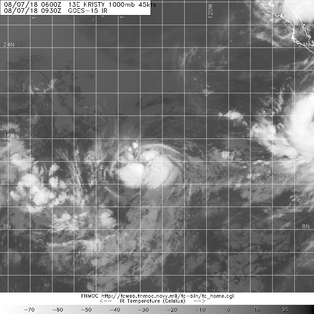
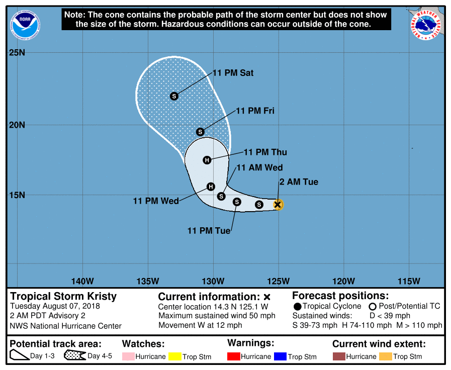
NHC 命名“Kristy”,巔峰上望一級颶風。
135
WTPZ43 KNHC 070850
TCDEP3

Tropical Storm Kristy Discussion Number   2
NWS National Hurricane Center Miami FL       EP132018
200 AM PDT Tue Aug 07 2018

Satellite images indicate that the cyclone has rapidly become better
organized, with a distinct curved band pattern now apparent. A
timely scatterometer pass indicated peak winds of 40-45 kt, so the
initial wind speed is set to 45 kt.  Continued intensification is
forecast while the storm remains over warm waters with light or
moderate shear. While there is no guidance indicating anything but
slow strengthening, some caution should be advised since Kristy has
already overachieved.  The wind speed forecast is raised from the
previous one, and is close to the HFIP corrected consensus.
Weakening should start by day 4 as the storm moves over cooler
waters.

Kristy appears to be moving at 265/10 kt. Model guidance is in
decent agreement on a subtropical ridge holding steady to the north
of the cyclone for a day or so, causing a westward motion.  After
that time, the agreement becomes quite poor due to large
uncertainties over how fast the ridge erodes, partially due to the
circulation of Hurricane John.  The GFS shows a fast erosion and a
turn to the north and northeast of Kristy, while the ECMWF keeps the
ridge in place, leading to the models being a "mere" 1200 miles
apart on the day-5 forecast of Kristy.  Interestingly, the model
consensus didn't change much, so I've decided to keep the forecast
basically the same, with the caveat that this is obviously a
low-confidence prediction.


FORECAST POSITIONS AND MAX WINDS

INIT  07/0900Z 14.3N 125.1W   45 KT  50 MPH
12H  07/1800Z 14.3N 126.5W   50 KT  60 MPH
24H  08/0600Z 14.5N 128.2W   55 KT  65 MPH
36H  08/1800Z 14.9N 129.4W   60 KT  70 MPH
48H  09/0600Z 15.6N 130.2W   65 KT  75 MPH
72H  10/0600Z 17.5N 130.5W   65 KT  75 MPH
96H  11/0600Z 19.5N 131.0W   55 KT  65 MPH
120H  12/0600Z 22.0N 133.0W   45 KT  50 MPH

$$
Forecaster Blake
085348_5day_cone_no_line_and_wind.png 20180807.0930.goes-15.ir.13E.KRISTY.45kts.1000mb.14.4N.124.5W.100pc.jpg

回復

使用道具 舉報

快速回覆
您需要登錄後才可以回帖 登錄 | 立即加入

本版積分規則

霧峰追風者

    主題

    帖子

    221萬

    積分

    16級[四級颶風]

    Rank: 16Rank: 16Rank: 16Rank: 16

16級[四級颶風]

發訊息

本平台僅供學術討論之用,預報應以氣象局為準

威普網站虛擬主機贊助公司

臺灣第一個天氣類型社群平台 即時天氣資訊、精準颱風動態

線上客服
FB傳送訊息
廣告行銷
精準行銷 物超所值
官方粉專
發佈 快速回復 返回頂部 返回列表