開啟輔助訪問
 找回密碼
 立即加入

02L.Beryl 環流袖珍升C1 登陸古巴北上 美東海域再次升格

簽到天數: 601 天

[LV.9]以壇為家II

2018-7-4 05:48 | 顯示全部樓層
本帖最後由 霧峰追風者 於 2018-9-26 04:01 編輯

  一級颶風  
編號:02 L
名稱:Beryl
Beryl_2018-07-06_1215Z.jpg
  基本資料  
擾動編號日期:2018 07 04 05
命名日期  :2018 07 05 23

二次升格日期:2018 07 14 23
撤編日期  :2018 07 16 05
登陸地點  :

  巔峰時期資料  
近中心最強風速
國家颶風中心(NHC):70 kts
海平面最低氣壓994 百帕

  過去路徑圖  
1024px-Beryl_2018_track.png
  擾動編號資料  
95L.INVEST.25kts-1010mb-9.0N-30.5W

20180703.2100.msg-4.ir.95L.INVEST.25kts.1010mb.9N.30.5W.100pc.jpg

以上資料來自:NHC颱風論壇整理製作

評分

參與人數 1水氣能量 +15 +1 收起 理由
t02436 + 15 + 1

查看全部評分

回復

使用道具 舉報

簽到天數: 601 天

[LV.9]以壇為家II

霧峰追風者|2018-7-4 10:44 | 顯示全部樓層
NHC 00Z展望提升至20%
2. A vigorous tropical wave is producing a concentrated area of
showers and thunderstorms several hundred miles southwest of the
Cabo Verde Islands.  Environmental conditions are forecast to be
somewhat conducive for gradual development of this disturbance over
the next few days while it moves westward to west-northwestward at
15 to 20 mph. By the weekend, however, conditions are expected to
become less favorable for tropical cyclone formation.
* Formation chance through 48 hours...low...20 percent.
* Formation chance through 5 days...low...20 percent.
two_atl_2d2.png

回復

使用道具 舉報

簽到天數: 601 天

[LV.9]以壇為家II

霧峰追風者|2018-7-5 06:36 | 顯示全部樓層
NHC 展望提升至50%
2. Satellite imagery indicates that shower activity associated with a
small area of low pressure and a tropical wave located several
hundred miles west-southwest of the Cabo Verde Islands has become
better organized during the past few hours.  Some additional
development of this system is possible, and a tropical depression
could form during the next day or two while it moves westward to
west-northwestward at 15 to 20 mph over the tropical Atlantic
Ocean. By the weekend, upper-level winds are expected to become less
conducive for development when the system approaches the Lesser
Antilles.
* Formation chance through 48 hours...medium...50 percent.
* Formation chance through 5 days...medium...50 percent.
two_atl_2d2 (1).png 95L_gefs_latest.png 95L_intensity_latest.png

回復

使用道具 舉報

簽到天數: 2141 天

[LV.Master]伴壇終老

周子堯@FB|2018-7-5 08:39 | 顯示全部樓層
NHC 展望提升至70%
2. Shower activity associated with a small area of low pressure and a
tropical wave located about 1000 miles west-southwest of the
Cabo Verde Islands continues to become better organized.  A tropical
depression is likely to form during the next day or two while the
system moves westward to west-northwestward at 15 to 20 mph over the
tropical Atlantic Ocean.  By the weekend, however, upper-level winds
are expected to become less conducive for development when the
system approaches the Lesser Antilles.
* Formation chance through 48 hours...high...70 percent.
* Formation chance through 5 days...high...70 percent.

Forecaster Beven
two_atl_2d2.png


回復

使用道具 舉報

簽到天數: 3291 天

[LV.Master]伴壇終老

t02436|2018-7-5 22:49 | 顯示全部樓層
編號02L,但僅看好混個名字。
000
WTNT42 KNHC 051443
TCDAT2

Tropical Depression Two Discussion Number   1
NWS National Hurricane Center Miami FL       AL022018
1100 AM AST Thu Jul 05 2018

For the past day or so, we've been monitoring a small area of low
pressure associated with a tropical wave over the tropical Atlantic
Ocean.  Despite a noticeable mid-level rotation in the convective
clouds, it had not been conclusive whether or not the system had a
closed circulation at the surface with a well-defined center.
However, the system appears more distinct and independent from the
Intertropical Convergence Zone as compared to yesterday, and
scatterometer data appears conclusive enough to support a closed,
yet tiny circulation.  We are now confident enough that the system
meets the criteria of a tropical cyclone, and have initiated
advisories on Tropical Depression Two with maximum winds of 30 kt,
which is supported by Dvorak classifications from TAFB and SAB.

The depression will be located in a relatively low-shear environment
for the next 3 days or so.  However, the small cyclone is surrounded
by abundant dry air, and the system will be moving over marginally
warm waters during the next few days, which could both limit
intensification.  The NHC official forecast allows for some slight
strengthening and most closely follows the HFIP Corrected Consensus
guidance (HCCA), showing the depression becoming a tropical storm
within the next 24 hours.  Between 72 and 96 hours, the system is
expected to begin encountering strong westerly shear and also
accelerate, both of which should cause it to degenerate into an open
wave east of the Lesser Antilles.

Even though the center has been difficult to locate, the initial
motion is estimated to be westward, or 270/14 kt.  The depression is
located to the south of a sprawling subtropical ridge, although a
break in the ridge over the central Atlantic may cause the system to
slow down a bit during the next 36 hours.  After that time, the
cyclone is likely to speed up again when it becomes situated to the
south of a new mid-level high.  The track guidance is in generally
good agreement, and the NHC official forecast is close to the TVCX
multi-model consensus and the HCCA guidance.

Even though the cyclone is expected to dissipate east of the Lesser
Antilles early next week, the remnant tropical wave will continue
moving quickly westward, likely bringing locally heavy rains and
gusty winds to portions of the Leeward Islands on Sunday and Monday.

FORECAST POSITIONS AND MAX WINDS

INIT  05/1500Z 10.2N  41.4W   30 KT  35 MPH
12H  06/0000Z 10.7N  43.1W   30 KT  35 MPH
24H  06/1200Z 11.4N  45.2W   35 KT  40 MPH
36H  07/0000Z 12.1N  47.2W   35 KT  40 MPH
48H  07/1200Z 12.9N  49.6W   35 KT  40 MPH
72H  08/1200Z 14.7N  56.6W   35 KT  40 MPH
96H  09/1200Z...DISSIPATED

$$
Forecaster Berg

144424_5day_cone_with_line.png

GOES14302018186PJZVcr.jpg
回復

使用道具 舉報

簽到天數: 601 天

[LV.9]以壇為家II

霧峰追風者|2018-7-6 05:21 | 顯示全部樓層
本帖最後由 霧峰追風者 於 2018-7-6 06:35 編輯

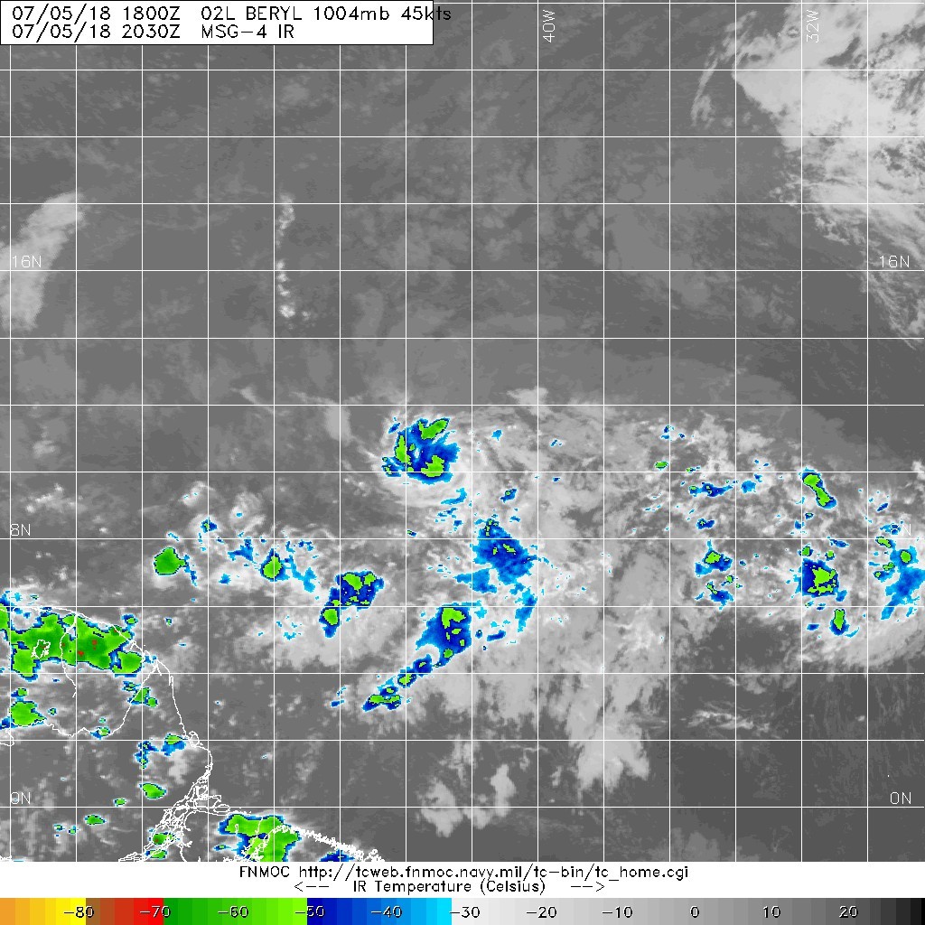
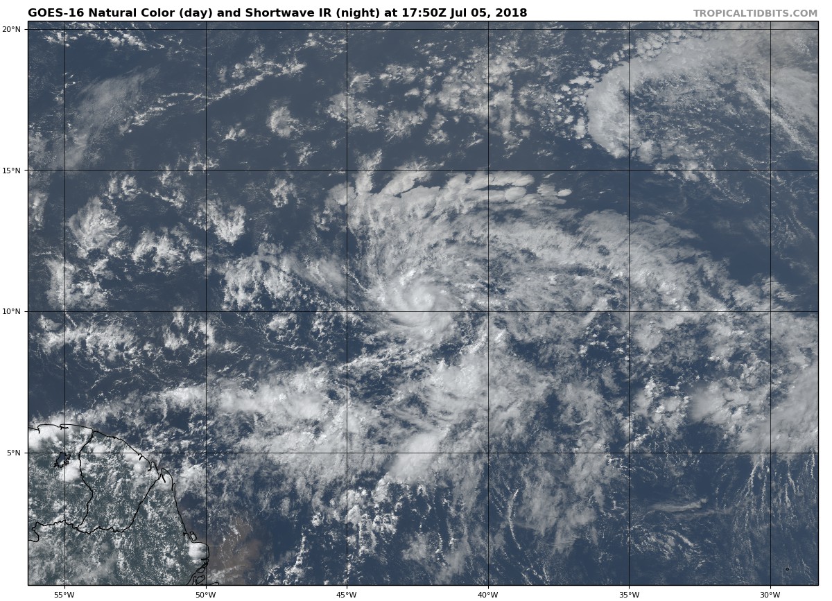
風眼隱現,NHC 18Z緊急命名Beryl,巔峰上望一級颶風。
000
WTNT42 KNHC 052018
TCDAT2

Tropical Storm Beryl Discussion Number   2
NWS National Hurricane Center Miami FL       AL022018
500 PM AST Thu Jul 05 2018

Beryl has been a bit of a surprise today, which is not uncommon for
tiny tropical cyclones such as itself.  A 1724 UTC SSMI microwave
pass and a 1853 UTC SSMI/S pass both revealed that the cyclone had
developed a well-defined 5 nmi-wide mid-level eye, and a dimple has
been apparent in visible satellite imagery.  It's usually difficult
to get a good handle on the intensity of these types of cyclones
given their small size, but data-T numbers from TAFB and SAB are a
consensus T3.0.  The initial intensity is therefore raised to 45 kt,
but there is a lot of uncertainty in this estimate.

If the initial intensity is uncertain, the future intensity is even
more of a quandary.  Despite being surrounded by abundant dry air,
Beryl has apparently been able to isolate itself and possibly
moisten the near-storm environment while located in an area of low
shear.  Since the shear is expected to remain quite low for the next
36 hours or so, and small cyclones like Beryl often have a tendency
to strengthen quickly over a short period of time, continued
intensification appears likely for the next day or so.  The updated
NHC intensity forecast most closely follows the statistical-
dynamical guidance, which lies at the upper end of the guidance
envelope, and brings Beryl to hurricane strength within 36 hours.
After that time, increasing westerly shear, partially due to Beryl
accelerating toward the west, is expected to cause weakening.  In
addition, every global model shows the cyclone opening up into a
tropical wave in 72-96 hours, which is what the NHC forecast
continues to depict.  It cannot be stressed enough, however, that
this is a low confidence forecast.

The one stable part of the forecast is Beryl's future track.  The
new guidance has not changed much from the previous forecast cycle,
and it continues to show Beryl slowing down a bit during the next 24
hours, followed by a west-northwestward acceleration in 48-72 hours
due to a strengthening ridge to the north.  The updated NHC track
forecast is just a bit south of the previous one and is closest to
the HCCA and Florida State Superensemble guidance.

Even though Beryl is expected to dissipate just east of the Lesser
Antilles early next week, the remnant tropical wave will continue
moving quickly westward and will likely bring locally heavy
rains and gusty winds to portions of the Leeward Islands on Sunday
and Monday.

Key Messages:

1. Due to its very small size, there is greater-than-usual
uncertainty in the analysis of Beryl's current intensity.
Confidence in the official intensity forecast is also much lower
than normal.  Rapid changes in intensity, both up and down, that are
difficult to predict are possible during the next couple of days.

2. While Beryl is still expected to dissipate as a tropical cyclone
by Monday before reaching the Lesser Antilles, there will likely
be some rain and wind impacts on those islands early next week.
Residents there should monitor products from their local weather
office for more information.

FORECAST POSITIONS AND MAX WINDS

INIT  05/2100Z 10.3N  42.8W   45 KT  50 MPH
12H  06/0600Z 10.8N  44.5W   55 KT  65 MPH
24H  06/1800Z 11.4N  46.3W   60 KT  70 MPH
36H  07/0600Z 12.1N  48.3W   65 KT  75 MPH
48H  07/1800Z 13.0N  51.0W   60 KT  70 MPH
72H  08/1800Z 14.5N  58.4W   50 KT  60 MPH
96H  09/1800Z...DISSIPATED

$$
Forecaster Berg
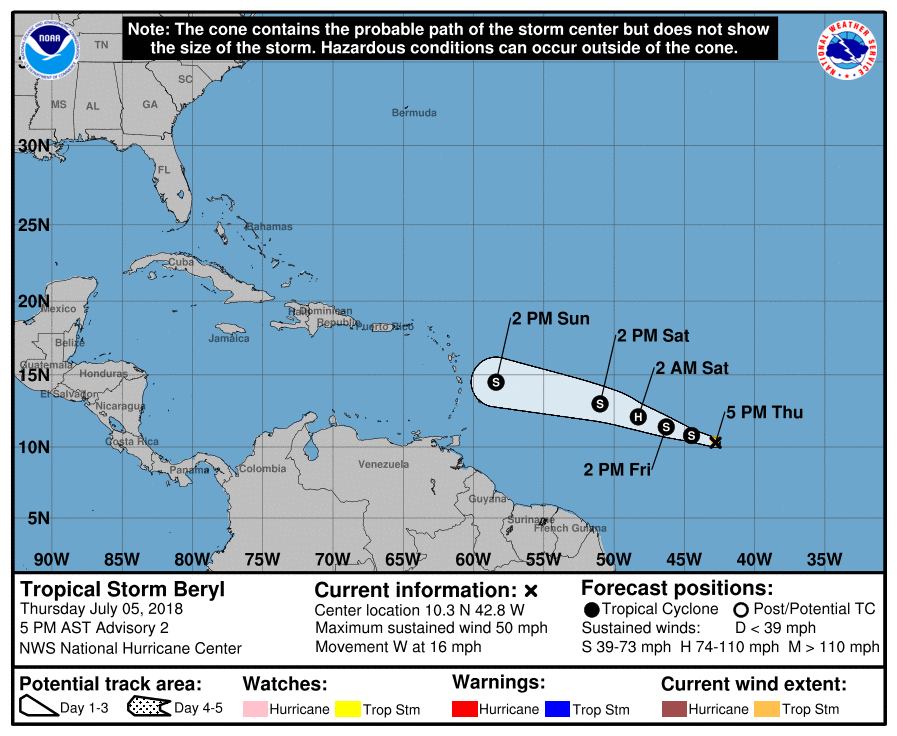
202017_5day_cone_no_line_and_wind.png 20180705.2030.msg-4.ircolor.02L.BERYL.45kts.1004mb.10.3N.42.3W.100pc.jpg 79_90766_3fcd0fa6caf351d.jpg

回復

使用道具 舉報

簽到天數: 3291 天

[LV.Master]伴壇終老

t02436|2018-7-6 18:02 | 顯示全部樓層
第一報原本還預期不會有所發展,09Z已經評價65節,巔峰上望75節。
000
WTNT42 KNHC 060854
TCDAT2

Hurricane Beryl Discussion Number   4
NWS National Hurricane Center Miami FL       AL022018
500 AM AST Fri Jul 06 2018

Deep convection associated with the tiny tropical cyclone has
continued to become better organized overnight.  An earlier AMSR2
microwave overpass showed a well-defined mid-level eye and a
pinhole eye has been apparent in the various GOES-16 satellite
channels since shortly after 0600 UTC and was most evident around
0715 UTC.  Although the clarity of the eye has waxed and waned since
that time, there is enough convective organization to increase the
initial intensity to 65 kt, making Beryl the first hurricane of the
2018 Atlantic hurricane season.

The cyclone has another 18-24 hour within very low vertical wind
shear conditions and over SSTS of 26-27 degrees Celsius.  These
favorable conditions suggest that the tiny hurricane is likely to
intensify further today.  The NHC intensity forecast calls for
additional strengthening and is at the upper-end of the intensity
guidance, but I would not be too surprised if the compact hurricane
reaches a slightly higher peak intensity than indicated below. By
36 hours, the shear is forecast to increase to more than 15 kt, and
it is expected to be greater than 20 kt shortly after that time.
This should cause the very small tropical cyclone to quickly
weaken, however as mentioned in the Key Messages below there is
greater uncertainty than usual regarding Beryl's intensity
forecast.  Although the updated NHC forecast shows Beryl
reaching the Lesser Antilles as a tropical storm it is highly
possible that the system will have degenerated into an open trough
by that time. Regardless of the system's status at 72 h, it is
likely to bring strong gusty winds and locally heavy rains to
portions of the Lesser Antilles Sunday and Monday.

The initial motion estimate remains 275/12 kt.  The track guidance
is in good agreement taking Beryl west-northwestward to the
south of a deep-layer ridge over the central Atlantic.  There
has been little overall change in the latest dynamical guidance and
the new NHC track forecast is similar to the previous advisory and
lies along the southern edge of the guidance envelope closest to
the latest ECMWF and HFIP correct consensus models.


Key Messages:

1. Due to its very small size, there is greater-than-usual
uncertainty in the analysis of Beryl's current intensity. Confidence
in the official intensity forecast is also much lower than normal.
Rapid changes in intensity, both up and down, that are difficult to
predict are possible during the next couple of days.

2. While Beryl is still to forecast to quickly weaken or dissipate
as a tropical cyclone on Monday before reaching the Lesser Antilles,
there will likely be some rain and wind impacts on those islands
early next week. Residents there should monitor products from their
local weather office for more information.


FORECAST POSITIONS AND MAX WINDS

INIT  06/0900Z 10.6N  45.1W   65 KT  75 MPH
12H  06/1800Z 11.0N  46.6W   75 KT  85 MPH
24H  07/0600Z 11.7N  48.6W   75 KT  85 MPH
36H  07/1800Z 12.7N  51.0W   65 KT  75 MPH
48H  08/0600Z 13.6N  54.4W   55 KT  65 MPH
72H  09/0600Z 15.4N  61.9W   45 KT  50 MPH
96H  10/0600Z...DISSIPATED

$$
Forecaster Brown

085919_5day_cone_with_line.png

GOES0930201818749ApxV.jpg

點評

不是還是得看美國東南方海面上的大西洋高氣壓未來的強度變化。  發表於 2018-7-8 11:45
預報強看好發展上看3~4級超級颶風,沒意外到時美國南部沿海地區又將爆發一波逃難潮。  發表於 2018-7-8 11:43
它大約在下週將會北上侵襲美國一帶。  發表於 2018-7-7 12:44
回復

使用道具 舉報

簽到天數: 601 天

[LV.9]以壇為家II

霧峰追風者|2018-7-11 13:17 | 顯示全部樓層
Boryl 的殘餘,NHC展望20%,逐漸北上。
1. The remnants of Beryl, a tropical wave moving northwestward across
the southeastern Bahamas, are producing gusty winds and locally
heavy rain from Hispaniola and southeastern Cuba northeastward
across the southeastern Bahamas and the Turks and Caicos into the
adjacent Atlantic waters.  Little development is expected tonight
due to unfavorable upper-level winds.  However, the disturbance is
expected to turn northward over the western Atlantic on Wednesday
where upper-level winds could become more conducive for the
regeneration of a tropical cyclone later this week.  An Air Force
Reserve reconnaissance aircraft is scheduled to investigate the
disturbance Wednesday afternoon, if necessary.  Regardless of
development, locally heavy rains and gusty winds are likely to
continue from eastern Cuba and Hispaniola northward across the
eastern Bahamas for the next day or two.  Additional information on
this system can be found in High Seas Forecasts issued by the
National Weather Service.
* Formation chance through 48 hours...low...20 percent.
* Formation chance through 5 days...medium...50 percent.
two_atl_2d1 (1).png 02L_intensity_latest.png 02L_gefs_latest.png

回復

使用道具 舉報

12下一頁
快速回覆
您需要登錄後才可以回帖 登錄 | 立即加入

本版積分規則

霧峰追風者

    主題

    帖子

    221萬

    積分

    16級[四級颶風]

    Rank: 16Rank: 16Rank: 16Rank: 16

16級[四級颶風]

發訊息

本平台僅供學術討論之用,預報應以氣象局為準

威普網站虛擬主機贊助公司

臺灣第一個天氣類型社群平台 即時天氣資訊、精準颱風動態

線上客服
FB傳送訊息
廣告行銷
精準行銷 物超所值
官方粉專
發佈 快速回復 返回頂部 返回列表