開啟輔助訪問
 找回密碼
 立即加入

04E.Carlotta 近岸飄移 減弱為熱帶低壓

簽到天數: 601 天

[LV.9]以壇為家II

2018-6-13 19:58 | 顯示全部樓層
本帖最後由 霧峰追風者 於 2018-6-25 08:32 編輯

  熱帶風暴  
編號:04 E
名稱:Carlotta

  基本資料  
擾動編號日期:2018 06 13 19
命名日期  :2018 06 16 02
撤編日期  :2018 06 19 08
登陸地點  :

  巔峰時期資料  
近中心最強風速
國家颶風中心(NHC):55 kts
海平面最低氣壓997 百帕

  過去路徑圖  

  擾動編號資料  
93E-INVEST.15kts-1010mb-15.9N-99.0W

20180613.1130.goes-15.ir.93E.INVEST.15kts.1010mb.15.9N.99W.030pc.jpg

NHC : 20%
1. An area of low pressure centered several hundred miles south-
southwest of the Gulf of Tehuantepec has become better defined
since yesterday.  Environmental conditions are forecast to be
somewhat conducive, and slow development could occur during the
next couple of days as the system drifts north-northwestward.  By
the weekend, interaction with land is expected to limit further
organization.  Regardless of development, locally heavy rain
causing flash floods and mudslides is possible over the southern
portions of the Mexican states of Guerrero and Oaxaca beginning in
a day or so and continuing into the weekend.
* Formation chance through 48 hours...low...20 percent.
* Formation chance through 5 days...low...30 percent.
two_pac_2d1.png

以上資料來自:NHC颱風論壇整理製作

評分

參與人數 1水氣能量 +15 +1 收起 理由
s6815711 + 15 + 1

查看全部評分

回復

使用道具 舉報

簽到天數: 601 天

[LV.9]以壇為家II

霧峰追風者|2018-6-14 06:52 | 顯示全部樓層
NHC 展望提升至40%
1. Satellite-derived wind data indicate that an area of low pressure
centered about 375 miles south-southeast of Acapulco, Mexico,
continues to become better defined.  Environmental conditions are
forecast to be somewhat conducive, and a tropical depression could
form over the next couple of days while the low drifts
north-northwestward.  By the weekend, interaction with land is
expected to limit further organization.  Regardless of development,
locally heavy rain causing flash floods and mudslides is possible
over the southern portions of the Mexican states of Guerrero and
Oaxaca beginning tomorrow and continuing into the weekend.
* Formation chance through 48 hours...medium...40 percent.
* Formation chance through 5 days...medium...50 percent.
two_pac_2d1 (5).png 20180613.2100.goes-15.ir.93E.INVEST.30kts.1008mb.11.4N.98.6W.100pc.jpg 93E_intensity_latest.png

回復

使用道具 舉報

簽到天數: 601 天

[LV.9]以壇為家II

霧峰追風者|2018-6-15 02:44 | 顯示全部樓層
NHC 展望提升至90%。
1. Satellite images indicate that an area of low pressure centered
about 120 miles south of Acapulco, Mexico, is becoming better
defined, and a tropical depression could be forming. If current
trends continue, advisories will be initiated this afternoon or
evening on this system. The low is expected to move slowly
northwestward near or over the coast of Mexico during the next
couple of days.  The system is forecast to produce heavy rains, with
flash floods and mudslides likely over the southern portions of the
Mexican states of Guerrero and Oaxaca through the weekend.
* Formation chance through 48 hours...high...90 percent.
* Formation chance through 5 days...high...90 percent.
two_pac_2d1 (6).png ep932018.18061406.gif 20180614.1800.goes15.x.ir1km_bw.93EINVEST.30kts-1008mb-147N-1001W.100pc.jpg

回復

使用道具 舉報

簽到天數: 3291 天

[LV.Master]伴壇終老

t02436|2018-6-15 08:59 | 顯示全部樓層
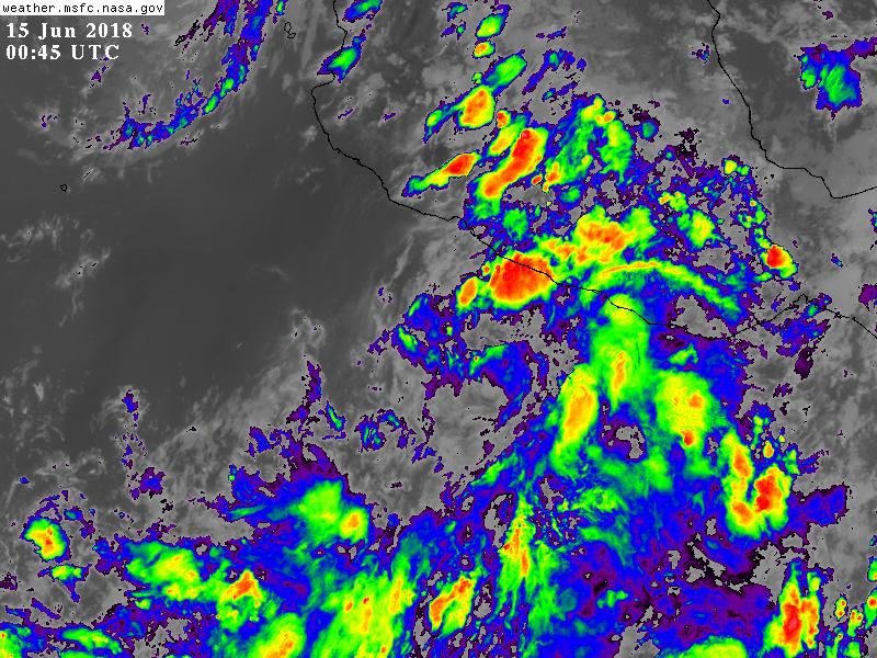
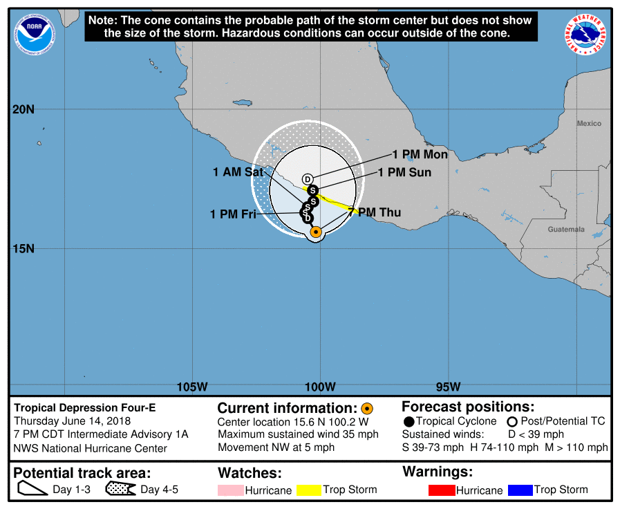
21Z升格04E,巔峰上望50節,將在近岸緩慢移動。
另外,今年是1966年以來第二早的04E,僅與紀錄(1974年)相差6小時。
ZCZC MIATCDEP4 ALL
TTAA00 KNHC DDHHMM

Tropical Depression Four-E Discussion Number   1
NWS National Hurricane Center Miami FL       EP042018
400 PM CDT Thu Jun 14 2018

Overnight scatterometer data indicate that the circulation of the
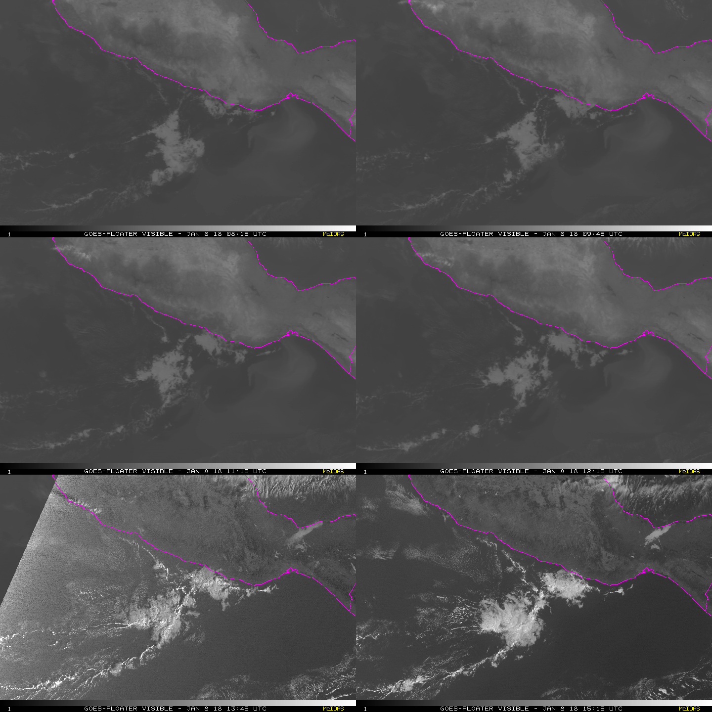
system was open on the northwestern side.  High-resolution GOES-16
1-min visible data indicate that the low is now closed, with a
well-enough defined circulation center.  Since there is plenty of
banded convection, this system is being designated as a tropical
depression, and the initial wind speed of 30 kt is based off the
overnight scatterometer data.

The initial motion estimate is an uncertain 325/5 kt.  A weak
mid-level ridge over Mexico is forecast to break down by tomorrow,
leaving the depression in an area of light steering currents.  Much
of the model guidance linger the system just south of the coast of
Mexico for the next couple of days until the cyclone gets drawn
northward into a larger trough currently seen over the western Gulf
of Mexico.  There is considerable uncertainty in the timing of this
poleward motion, however, with the UKMET, HMON, and COAMPS-TC models
faster than the rest of the guidance.  This seems like a pretty
clear case of staying near the model consensus, given the weak
steering flow that makes it nearly impossible to choose one model
over another one.  Thus, the official forecast shows a slow
northward motion, near the eastern Pacific model consensus TVCE, and
it should be emphasized that the forecast timing of landfall is
subject to large changes in the future.

The system is not particularly well organized at the moment, with a
few swirls seen in the visible imagery rotating around the larger
gyre.  After the low consolidates, light-to-moderate shear with
very warm waters, and high mid-level humidity should lead to steady
intensification.  This is a tricky forecast, however, since land is
so close to the north, which would prevent much strengthening.  The
official forecast is a blend of the statistical-dynamical guidance
and the regional hurricane guidance, a bit lower than the model
consensus since the HWRF keeps the cyclone well offshore (unlike
the official prediction), leading to a stronger storm.

It has been an active early part of the eastern Pacific season.
This is the 2nd earliest 4th tropical cyclone on record in the
basin during the satellite era (1966-present), only 6 hours behind
the previous record in 1974.


FORECAST POSITIONS AND MAX WINDS

INIT  14/2100Z 15.5N 100.1W   30 KT  35 MPH
12H  15/0600Z 16.1N 100.5W   30 KT  35 MPH
24H  15/1800Z 16.3N 100.6W   35 KT  40 MPH
36H  16/0600Z 16.5N 100.5W   40 KT  45 MPH
48H  16/1800Z 16.7N 100.3W   50 KT  60 MPH
72H  17/1800Z 17.1N 100.3W   40 KT  45 MPH...INLAND
96H  18/1800Z 17.5N 100.5W   20 KT  25 MPH...POST-TROP/REMNT LOW
120H  19/1800Z...DISSIPATED

$$
Forecaster Blake

NNNN
233159_5day_cone_with_line.png

GOES00452018166uocj3y.jpg

vis-animated.gif
回復

使用道具 舉報

簽到天數: 601 天

[LV.9]以壇為家II

霧峰追風者|2018-6-16 06:48 | 顯示全部樓層
NHC 18Z近岸命名"Carlotta",即將登陸墨西哥西岸。
000
WTPZ44 KNHC 152032
TCDEP4

Tropical Storm Carlotta Discussion Number   5
NWS National Hurricane Center Miami FL       EP042018
400 PM CDT Fri Jun 15 2018

Satellite images indicate that Carlotta is slowly getting better
organized, with lots of banding features.   ASCAT data indicated
peak winds of near 35 kt, close to the coast of Mexico, and this
will be the initial wind speed, matching the latest Dvorak estimates
from TAFB/SAB.

Radar data from Acapulco suggest that Carlotta hasn't moved a lot
in the past few hours, and continues moving slowly to the northeast.
The storm should get steered in that general direction through
landfall early tomorrow due to the influences of a large trough
over the western Gulf of Mexico.  Little change was made to the
official track forecast, except the landfall is about 6 hours
sooner. Carlotta doesn't have much time left to intensify, but could
strengthen a little more before the small cyclone quickly dissipates
over Mexico.

Although this system is expected to have only a low wind threat,
there is a significant risk of life-threatening flash floods and
mudslides over the southern parts of Guerrero and Oaxaca due to
moist southwesterly flow intersecting the southern Sierra Madre
mountains. Please see products issued by your local weather office
for more details.

FORECAST POSITIONS AND MAX WINDS

INIT  15/2100Z 16.1N  99.3W   35 KT  40 MPH
12H  16/0600Z 16.4N  99.0W   40 KT  45 MPH
24H  16/1800Z 16.9N  98.8W   30 KT  35 MPH...INLAND
36H  17/0600Z...DISSIPATED

$$
Forecaster Blake
203344_5day_cone_no_line_and_wind.png 20180615.2111.f16.ir.olsircomp.04E.CARLOTTA.x.jpg


回復

使用道具 舉報

簽到天數: 3291 天

[LV.Master]伴壇終老

t02436|2018-6-17 11:40 | 顯示全部樓層
03Z評價55節、997百帕,緩慢飄向墨西哥,北側眼牆已經上岸,中心24小時內會登陸。
000
WTPZ44 KNHC 170217
TCDEP4

Tropical Storm Carlotta Discussion Number  10
NWS National Hurricane Center Miami FL       EP042018
1000 PM CDT Sat Jun 16 2018

Carlotta has surprised us this evening.  Radar images from Acapulco,
Mexico, indicate that the storm has strengthened and its structure
has improved significantly.
  The radar data indicate that Carlotta
has a well-defined, but tiny, inner core and the eye has been
contracting during the past few hours.  In addition, the radar
echoes in the eyewall has been getting stronger and more symmetric
around the eye.  The initial wind speed is set to 55 kt, in
agreement with a Dvorak classification from TAFB.

Carlotta is very close to the coast of southern Mexico and, in
fact, the northern eyewall is partially onshore.  Since the
storm is expected to interact with land and is forecast to move
inland overnight or Sunday morning, it appears unlikely that
Carlotta will strengthen much more.  Once inland, fast weakening is
expected and Carlotta should dissipate over the high terrain of
Mexico Sunday night or early Monday.

The storm has moved more to the west than previous thought, likely
due to the influence of a narrow mid-level ridge to its north.  The
new forecast is adjusted well to the west of the previous one, and
is in fair agreement with the latest consensus models.

Regardless of whether the center moves inland, the threat of heavy
rainfall and potential of life-threatening flash floods and
mudslides continue over the southern parts of Guerrero and Oaxaca.
The rainfall threat will be enhanced by moist southwesterly flow
over the southern Sierra Madre mountains of Mexico.  For details,
please see products issued by your local weather office.

FORECAST POSITIONS AND MAX WINDS

INIT  17/0300Z 16.6N  99.9W   55 KT  65 MPH
12H  17/1200Z 17.0N 100.4W   50 KT  60 MPH...NEAR THE COAST
24H  18/0000Z 17.5N 100.9W   35 KT  40 MPH...INLAND
36H  18/1200Z 18.0N 101.5W   20 KT  25 MPH...POST-TROP/INLAND
48H  19/0000Z...DISSIPATED

$$
Forecaster Cangialosi

021815_5day_cone_with_line.png

GOES03152018168SQRhJh.jpg
回復

使用道具 舉報

快速回覆
您需要登錄後才可以回帖 登錄 | 立即加入

本版積分規則

霧峰追風者

    主題

    帖子

    221萬

    積分

    16級[四級颶風]

    Rank: 16Rank: 16Rank: 16Rank: 16

16級[四級颶風]

發訊息

本平台僅供學術討論之用,預報應以氣象局為準

威普網站虛擬主機贊助公司

臺灣第一個天氣類型社群平台 即時天氣資訊、精準颱風動態

線上客服
FB傳送訊息
廣告行銷
精準行銷 物超所值
官方粉專
發佈 快速回復 返回頂部 返回列表