|
|
 霧峰追風者|2017-12-1 11:28
|
顯示全部樓層
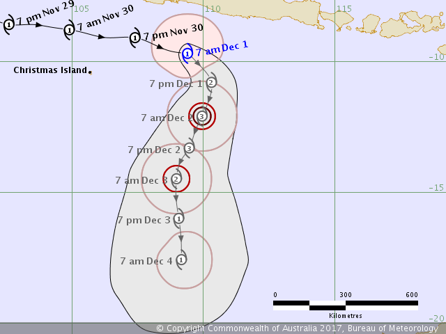
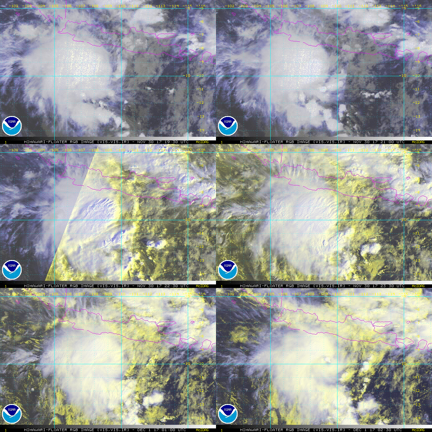
BoM 上望三級熱帶氣旋,逐漸南下。
IDW27700
TROPICAL CYCLONE TECHNICAL BULLETIN: AUSTRALIA - WESTERN REGION
Issued by PERTH TROPICAL CYCLONE WARNING CENTRE
at: 0143 UTC 01/12/2017
Name: Tropical Cyclone Dahlia
Identifier: 03U
Data At: 0000 UTC
Latitude: 9.7S
Longitude: 109.4E
Location Accuracy: within 25 nm [45 km]
Movement Towards: east southeast [120 deg]
Speed of Movement: 8 knots [16 km/h]
Maximum 10-Minute Wind: 45 knots [85 km/h]
Maximum 3-Second Wind Gust: 65 knots [120 km/h]
Central Pressure: 992 hPa
Radius of 34-knot winds NE quadrant: 90 nm [165 km]
Radius of 34-knot winds SE quadrant: 50 nm [95 km]
Radius of 34-knot winds SW quadrant: 60 nm [110 km]
Radius of 34-knot winds NW quadrant: 90 nm [165 km]
Radius of 48-knot winds NE quadrant:
Radius of 48-knot winds SE quadrant:
Radius of 48-knot winds SW quadrant:
Radius of 48-knot winds NW quadrant:
Radius of 64-knot winds:
Radius of Maximum Winds: 25 nm [45 km]
Dvorak Intensity Code: T3.0/3.0/D0.5/24HRS STT:S0.0/6HRS
Pressure of outermost isobar: 1004 hPa
Radius of outermost closed isobar: 150 nm [280 km]
FORECAST DATA
Date/Time : Location : Loc. Accuracy: Max Wind : Central Pressure
[UTC] : degrees : nm [km]: knots[km/h]: hPa
+06: 01/0600: 10.2S 109.9E: 035 [070]: 045 [085]: 991
+12: 01/1200: 10.8S 110.3E: 050 [090]: 050 [095]: 987
+18: 01/1800: 11.5S 110.2E: 060 [115]: 060 [110]: 980
+24: 02/0000: 12.1S 110.0E: 075 [135]: 065 [120]: 977
+36: 02/1200: 13.3S 109.5E: 095 [175]: 065 [120]: 976
+48: 03/0000: 14.5S 109.0E: 115 [210]: 055 [100]: 984
+60: 03/1200: 16.0S 109.1E: 130 [245]: 045 [085]: 991
+72: 04/0000: 17.6S 109.2E: 150 [280]: 040 [075]: 994
+96: 05/0000: 19.7S 110.2E: 195 [365]: 030 [055]: 998
+120: 06/0000: 21.3S 111.9E: 285 [525]: 025 [045]: 1002
REMARKS:
TC Dahlia has continued to move east over the last few hours. It now appears the
low level circulation centre has moved further under the deep convection after
being exposed to the east of the deepest convection. This is consistent with a
decrease in easterly wind shear.
Dvorak analysis: FT/CI=3.0 based on a time-averaged shear pattern and MET,
although the latest imagery is showing indications that it is now closer to 3.5.
Models are consistent with a turn to the south during Saturday.
Further development is expected as the shear eases and forecast intensity has
been increased to category 3 during Saturday. On Sunday model guidance suggests
a weakening trend and this becomes more obvious by Monday as the system
encounters cooler water south of 18S and dry air wraps around from the west.
Gales may persist to the southwest as the system interacts with the synoptic
SE'ly flow associated with the sub-tropical ridge.
Copyright Commonwealth of Australia
==
The next bulletin for this system will be issued by: 01/0730 UTC by Perth TCWC.


|
|