開啟輔助訪問
 找回密碼
 立即加入

14L.Lee 繼Harvey後大西洋第5個MH

簽到天數: 971 天

[LV.10]以壇為家III

jwpk9899|2017-9-27 11:56 | 顯示全部樓層
03Z提升強度到95kt 離MH差一步了 真的覺得這隻沒實測很可惜

INIT  27/0300Z 30.0N  55.5W   95 KT 110 MPH
12H  27/1200Z 30.5N  56.4W  100 KT 115 MPH
24H  28/0000Z 31.6N  57.1W   95 KT 110 MPH
36H  28/1200Z 33.4N  57.0W   90 KT 105 MPH
48H  29/0000Z 36.0N  55.2W   80 KT  90 MPH
72H  30/0000Z 43.7N  43.6W   65 KT  75 MPH
96H  01/0000Z...DISSIPATED


at201714_sat.jpg

點評

他位置太尷尬 NHC兩個機場都飛不到  發表於 2017-9-27 13:29
NHC:老子只管Maria啦~  發表於 2017-9-27 12:08
回復

使用道具 舉報

簽到天數: 601 天

[LV.9]以壇為家II

霧峰追風者|2017-9-27 22:11 | 顯示全部樓層
強度升三級颶風。西側眼牆感覺比較薄。 20170927.1051.noaa18.89rgb.14L.LEE.100kts.964mb.30.3N.56.5W.075pc.jpg 20170927.1315.goes-13.ircolor.14L.LEE.100kts.964mb.30.3N.56.5W.100pc.jpg

點評

以前台灣早期區分颱風規模大小的標準是以暴風半徑大小,配合中心風速  發表於 2017-9-30 20:29
Major hurricane 直白的翻譯大概就是大型颶風 不過廣義來說就是大於等於100kt的颶風  發表於 2017-9-29 11:58
MH的全名是和原文是?...  發表於 2017-9-29 06:36
原來 我來沒把Katia變成Otis這段算進去  發表於 2017-9-28 11:14
HARVEY(C4), IRMA(C5), JOSE(C4), KATIA-OTIS(C3), LEE(C3), MARIA(C5)  發表於 2017-9-28 01:26
誒0.0 可是我怎麼算從哈維開始都是5個耶  發表於 2017-9-28 01:20
連續6個MH沒錯  發表於 2017-9-28 00:05
多算一個 五個MH@@  發表於 2017-9-27 22:47
連續6個MH了  發表於 2017-9-27 22:22
回復

使用道具 舉報

簽到天數: 588 天

[LV.9]以壇為家II

Meow|2017-9-29 00:57 | 顯示全部樓層
本帖最後由 Meow 於 2017-9-29 01:08 編輯

9月27日百慕達東南東方颶風李位處巔峰
Lee 2017-09-27 1450Z.jpg
https://commons.wikimedia.org/wiki/File:Lee_2017-09-27_1450Z.jpg
回復

使用道具 舉報

簽到天數: 601 天

[LV.9]以壇為家II

霧峰追風者|2017-9-30 17:45 | 顯示全部樓層
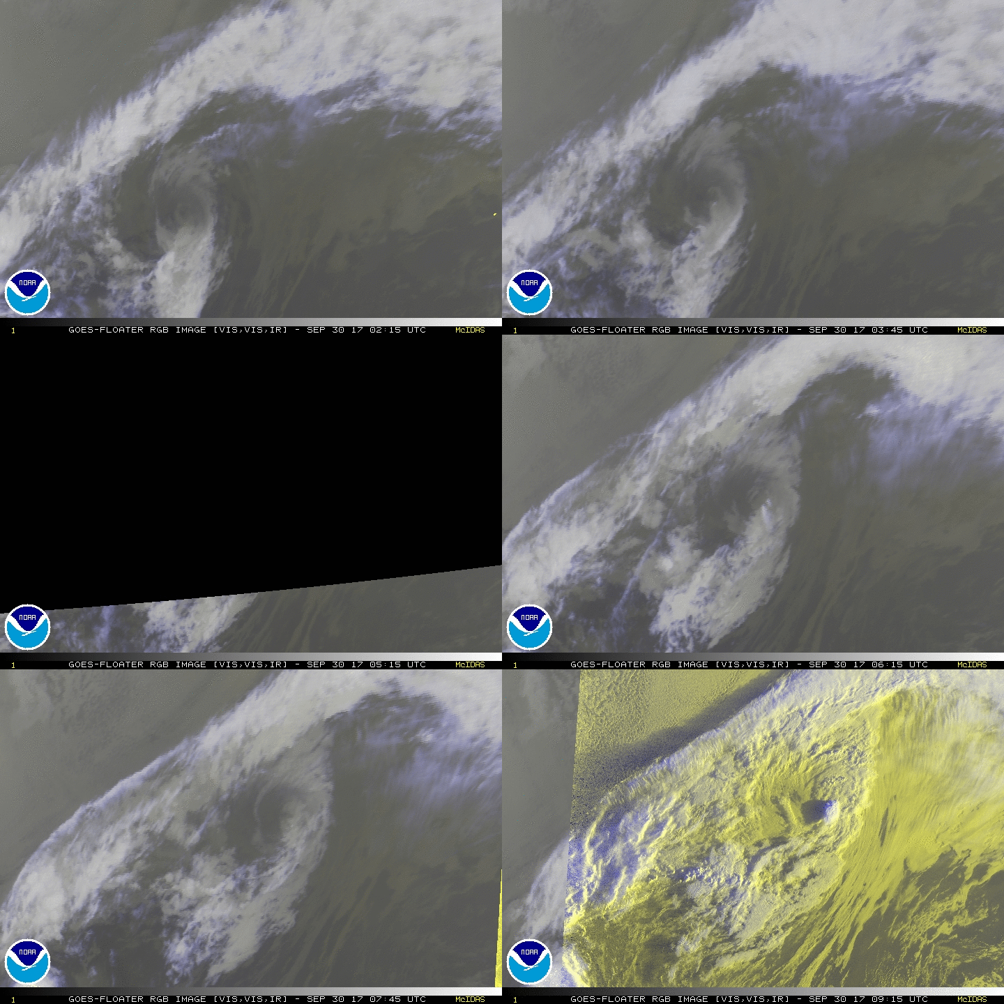
NHC 最後一報,即將轉化。
ZCZC MIATCDAT4 ALL
TTAA00 KNHC DDHHMM

Post-Tropical Cyclone Lee Discussion Number  49
NWS National Hurricane Center Miami FL       AL142017
500 AM AST Sat Sep 30 2017

Lee is now over water colder than 20 degrees Celsius and is being
blasted by 35 kt of west-northwesterly shear, and it has not been
producing deep convection for at least the past 12 hours.  The
cyclone has therefore become post tropical, and this will be the
last advisory.  Without any deep convection, subjective and
objective Dvorak numbers have decreased, and the initial intensity
is estimated to be 45 kt.

Lee continues to accelerate northeastward with an initial motion
estimate of 050/44 kt.  Continued acceleration is expected today,
although the global model fields indicate that Lee's circulation
will open up into a trough within the next 6 to 12 hours.  A
12-hour point is provided in the official forecast for continuity's
sake, but Lee will most likely have dissipated by then.

Additional information on this system can be found in High Seas
Forecasts issued by Meteo France under WMO header FQNT50 LFPW and in
High Seas Forecasts issued by the UK Met Office under WMO header
FQNT21 EGRR.  These forecasts are available on the web at
http://www.meteofrance.com/previsions-meteo-marine/bulletin and at
http://www.metoffice.gov.uk/public/weather/marine-high-seas/.

FORECAST POSITIONS AND MAX WINDS

INIT  30/0900Z 46.7N  35.6W   45 KT  50 MPH...POST-TROPICAL
12H  30/1800Z 49.9N  24.6W   45 KT  50 MPH...POST-TROPICAL
24H  01/0600Z...DISSIPATED

$$
Forecaster Berg

NNNN
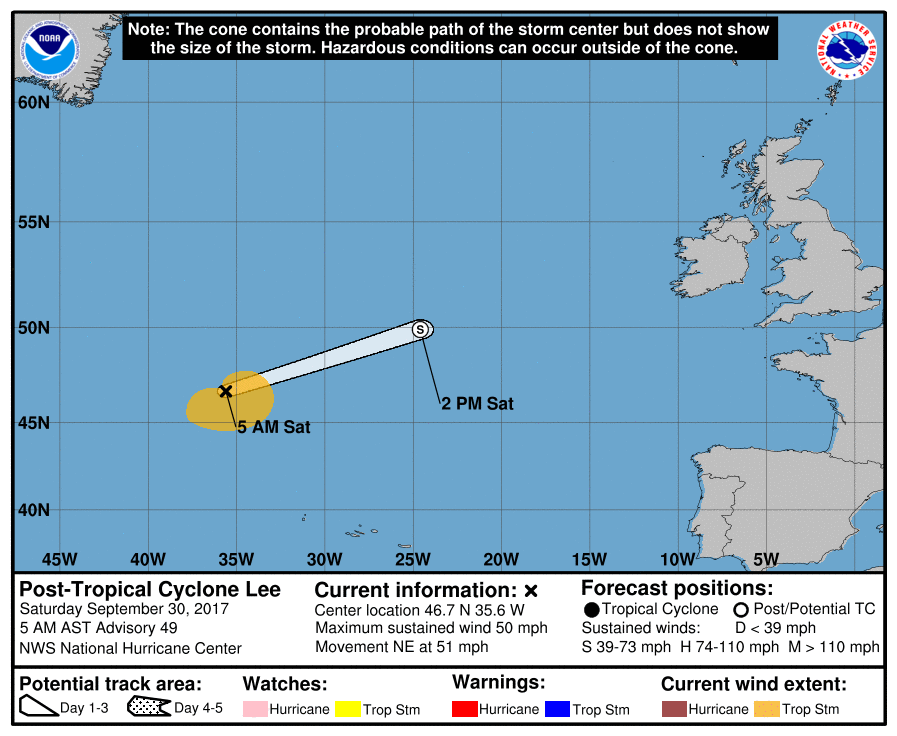
084457_5day_cone_no_line_and_wind.png rgb-animated (13).gif


點評

已經完全轉化,可能已經完全消散.  發表於 2017-10-1 18:32
回復

使用道具 舉報

123
快速回覆
您需要登錄後才可以回帖 登錄 | 立即加入

本版積分規則

本平台僅供學術討論之用,預報應以氣象局為準

威普網站虛擬主機贊助公司

臺灣第一個天氣類型社群平台 即時天氣資訊、精準颱風動態

線上客服
FB傳送訊息
廣告行銷
精準行銷 物超所值
官方粉專
發佈 快速回復 返回頂部 返回列表