開啟輔助訪問
 找回密碼
 立即加入

14E.Lidia 橫掃下加利福尼亞半島 逐漸減弱

簽到天數: 601 天

[LV.9]以壇為家II

2017-8-28 19:51 | 顯示全部樓層
本帖最後由 霧峰追風者 於 2017-12-12 07:35 編輯

  熱帶風暴  
編號:14 E
名稱:Lidia
800px-Lidia_2017-08-31_2023Z.jpg
  基本資料  
擾動編號日期:2017 08 28 19
命名日期  :2017 08 31 08
撤編日期  :2017 09 00 00
登陸地點  :墨西哥 南下加利福尼亞州 拉巴斯

  巔峰時期資料  
近中心最強風速
國家颶風中心(NHC):55 kts
海平面最低氣壓 :987 百帕

  過去路徑圖  
1920px-Lidia_2017_track.png
  擾動編號資料  
94E-INVEST-25kts-1007mb-16N-103W

20170828.1115.goes-13.ir.94E.INVEST.25kts.1007mb.16N.103W.100pc.jpg
NHC:50%
1. A trough of low pressure located several hundred miles south of the
southern tip of the Baja California peninsula is producing a
widespread area of disorganized showers and thunderstorms.
Environmental conditions are forecast to be conducive for
development, and this system is likely to become a tropical cyclone
within two or three days while it moves generally northward or
northwestward.
* Formation chance through 48 hours...medium...50 percent.
* Formation chance through 5 days...high...80 percent.

two_pac_2d1.png

以上資料來自:NHC、颱風論壇整理製作

評分

參與人數 1水氣能量 +15 收起 理由
jwpk9899 + 15

查看全部評分

回復

使用道具 舉報

簽到天數: 601 天

[LV.9]以壇為家II

霧峰追風者|2017-8-29 10:16 | 顯示全部樓層
NHC展望提升至70%,環流廣泛,整合發展中。
1. An elongated area of low pressure centered about a few hundred miles
south-southeast of Manzanillo, Mexico, is producing widespread
disorganized showers and thunderstorms.  Environmental conditions
are forecast to be conducive for development, and this system is
expected to become a tropical cyclone within the next couple of days
while it moves generally northward or northwestward near the coast
of southwestern Mexico and Baja California Sur.  Residents in those
areas should monitor the progress of this system, and tropical
storm watches could be required for a portion of the area on
Tuesday.  Regardless of development, very heavy rain is expected in
southwestern Mexico and Baja California Sur over the next few days
and could cause life-threatening flash floods and mudslides.
* Formation chance through 48 hours...high...70 percent.
* Formation chance through 5 days...high...90 percent.
two_pac_2d1 (5).png


回復

使用道具 舉報

簽到天數: 601 天

[LV.9]以壇為家II

霧峰追風者|2017-8-30 06:43 | 顯示全部樓層
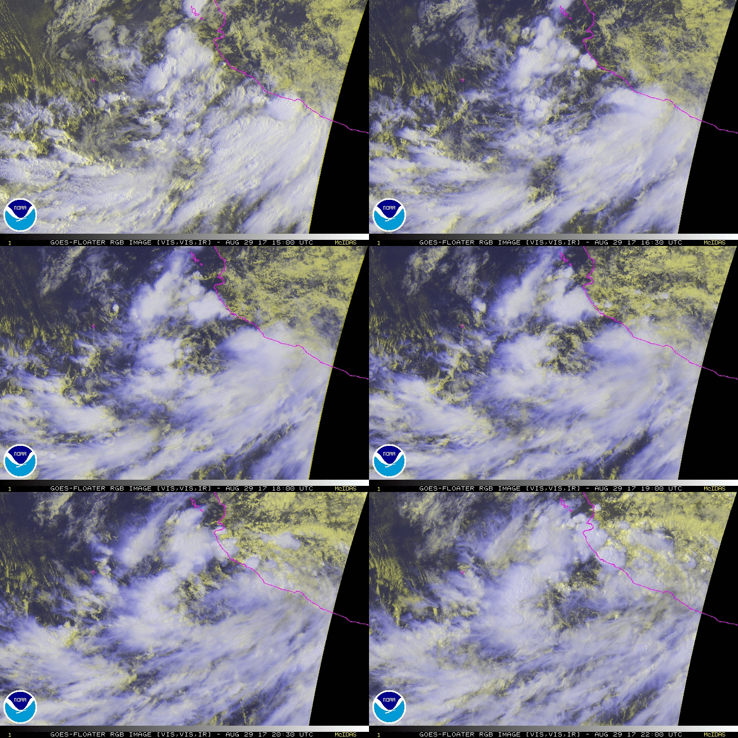
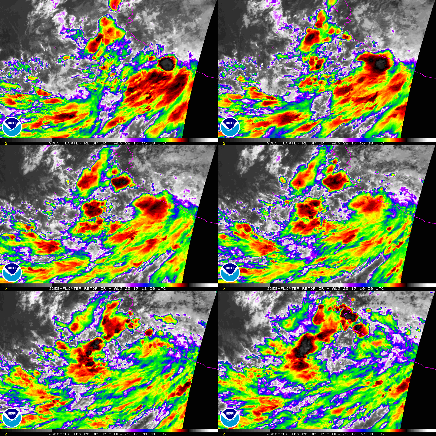
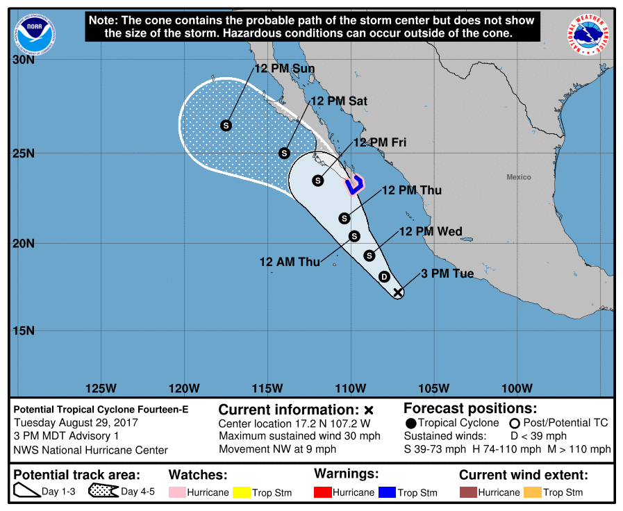
NHC 18Z升格"潛在熱帶氣旋14E",有機會在24H內命名,將沿著墨西哥西部海域北上。
ZCZC MIATCDEP4 ALL
TTAA00 KNHC DDHHMM

Potential Tropical Cyclone Fourteen-E Discussion Number   1
NWS National Hurricane Center Miami FL       EP142017
300 PM MDT Tue Aug 29 2017

Satellite images indicate that the large disturbance southwest of
Mexico is gradually becoming better organized.  While the system
still lacks a well-defined center, all indications are that it will
become a tropical storm tomorrow.  Since the system is forecast to
bring tropical-storm-force winds to Baja California Sur within 36
hours, advisories are being initiated on a potential tropical
cyclone.  The system has 2-3 days over very warm water with
decreasing shear.  Although the system is quite broad for the
moment, the favorable environmental conditions noted above should
allow for at least steady strengthening.  Thus, the official
forecast is higher than the model consensus, but lower than the
bullish SHIPS model.

The initial motion is a highly uncertain 315/8.  A weak ridge over
central Mexico should steer the cyclone to the northwest or north-
northwest for the next few days.  Thereafter, the system should turn
toward the west-northwest as it moves around a stronger ridge over
the southwestern United States.  While there is some spread in the
guidance, the models are in reasonable agreement for a first
forecast, taking the system near or just west of Baja California
Sur.  The official NHC track prediction is between the model
consensus and the NOAA corrected-consensus model HCCA.

It is important to note that outside the watch/warning area, very
heavy rain is possible, which could cause life-threatening
flooding and mudslides over southwestern Mexico.  In addition,
wind gusts to tropical-storm force are possible along the coast of
Michoacan, Colima and Jalisco states tonight into early Wednesday
due to the large circulation.

The National Hurricane Center now has the option to issue
advisories, watches, and warnings for disturbances that are not yet
a tropical cyclone, but which pose the threat of bringing tropical
storm or hurricane conditions to land areas within 48 hours. Under
previous policy this was not possible.  These systems are known as
Potential Tropical Cyclones in advisory products and are numbered
from the same list as depressions.

Because of the threat to Baja California Sur, advisories have been
initiated on Potential Tropical Cyclone Fourteen-E and the
appropriate watches and warnings have been issued by the government
of Mexico.  Advisory packages will continue until the threat of
tropical-storm-force winds for land areas sufficiently diminishes,
although if the system becomes a tropical cyclone, the normal rules
for discontinuing advisories would apply.  Users should be aware
that forecast uncertainty for disturbances is generally larger than
for tropical cyclones, especially beyond 48-72 hours.

FORECAST POSITIONS AND MAX WINDS

INIT  29/2100Z 17.2N 107.2W   25 KT  30 MPH...POTENTIAL TROP CYCLONE
12H  30/0600Z 18.1N 108.0W   30 KT  35 MPH
24H  30/1800Z 19.3N 108.9W   35 KT  40 MPH...TROPICAL STORM
36H  31/0600Z 20.4N 109.8W   45 KT  50 MPH
48H  31/1800Z 21.4N 110.4W   55 KT  65 MPH
72H  01/1800Z 23.5N 112.0W   60 KT  70 MPH
96H  02/1800Z 25.0N 114.0W   50 KT  60 MPH
120H  03/1800Z 26.5N 117.5W   35 KT  40 MPH

$$
Forecaster Blake

NNNN
212628_5day_cone_no_line_and_wind.png rgb-animated (11).gif rbtop-animated (16).gif


回復

使用道具 舉報

簽到天數: 601 天

[LV.9]以壇為家II

霧峰追風者|2017-8-31 08:28 | 顯示全部樓層
本帖最後由 霧峰追風者 於 2017-8-31 10:48 編輯

NHC 00Z命名"Lidia",逐漸北上,趨向加利福尼亞半島。
000
WTPZ44 KNHC 310237
TCDEP4

Tropical Storm Lidia Discussion Number   6
NWS National Hurricane Center Miami FL       EP142017
900 PM MDT Wed Aug 30 2017

Satellite images indicate that the circulation, although broad, is
more consolidated, and convection has become more concentrated near
the center. However, there is no evidence of an inner core at this
time. Data from a unmanned NASA Global Hawk aircraft currently in
the area of Lidia, and observations from the Mexican Navy automatic
weather stations, were very helpful in determining the structure of
the cyclone. The best estimate of the initial intensity is 35 kt.

Lidia is within a very favorable environment of low shear, and the
ocean is warm.  The only factor against a higher intensification
rate appears to be the large size of the cyclone. The NHC forecast
calls for gradual strengthening during the next 12 to 24 hours, and
Lidia has a chance to be near hurricane strength before the cyclone
begins to interact with the high terrain of the Baja California
peninsula. After that time, gradual weakening should then begin.

The overall circulation is still moving toward the north-northwest
or 345 degrees at 6 kt. Lidia is being steered by the flow between
a weak ridge over Mexico and a weak cyclonic gyre to the west. This
pattern will persist, and the cyclone should continue on the same
general track for the next 2 days. Once the cyclone reaches the
central portion of Baja California peninsula, a ridge to the north
is forecast to amplify, and this flow pattern will force a weaker
Lidia on a more west-northwest track toward cold waters.

It is important to emphasize that Lidia is a large system
accompanied by very heavy rains which are already occuring over
portions of western Mexico and Baja California Sur. These rains are
already causing threatening flash floods and mudslides and
regardless of exactly how strong Lidia becomes, this should be a
significant hazard.

FORECAST POSITIONS AND MAX WINDS

INIT  31/0300Z 20.7N 109.2W   35 KT  40 MPH
12H  31/1200Z 21.6N 109.5W   45 KT  50 MPH
24H  01/0000Z 22.8N 110.0W   55 KT  65 MPH
36H  01/1200Z 23.8N 110.6W   45 KT  50 MPH...INLAND
48H  02/0000Z 25.5N 111.7W   40 KT  45 MPH...INLAND
72H  03/0000Z 28.0N 114.3W   25 KT  30 MPH...INLAND
96H  04/0000Z 29.0N 117.0W   25 KT  30 MPH...POST-TROP/REMNT LOW
120H  05/0000Z 29.5N 119.5W   25 KT  30 MPH...POST-TROP/REMNT LOW

$$
Forecaster Avila
233920_5day_cone_no_line_and_wind.png rgb-animated (13).gif rbtop-animated (17).gif

回復

使用道具 舉報

簽到天數: 601 天

[LV.9]以壇為家II

霧峰追風者|2017-9-1 02:53 | 顯示全部樓層
強度略為提升至55kts,即將登陸加利福尼亞半島
174216_5day_cone_no_line_and_wind.png rb-animated (4).gif

回復

使用道具 舉報

簽到天數: 3291 天

[LV.Master]伴壇終老

t02436|2017-9-1 23:06 | 顯示全部樓層
中心登陸下加利福尼亞半島。
000
WTPZ44 KNHC 011450
TCDEP4

Tropical Storm Lidia Discussion Number  12
NWS National Hurricane Center Miami FL       EP142017
900 AM MDT Fri Sep 01 2017

Satellite imagery indicates that the center of Lidia has made
landfall on the Baja California peninsula west of La Paz.
  The
convective organization of the cyclone has decreased over the past
several hours and, based on this and continuity from the previous
advisory, the initial intensity is decreased to 50 kt.  The storm
continues to have a large wind field in the eastern semicircle as
shown by a recent report of tropical-storm-force winds in Los
Mochis on the Mexican mainland.

The initial motion is 325/8.  Lidia remains between a mid-level high
centered over the southwestern United States and a mid-level trough
southwest over the Pacific, and these features should keep Lidia on
a general northwestward course for the next three days.  The new
forecast track has the center over or just off of the west coast of
the Baja California peninsula for the next 30-36 h before emerging
over the Pacific Ocean.  Overall the new track is an update of the
previous track that lies close to the various consensus models.

Steady weakening is expected while the circulation interacts with
the mountainous terrain of Baja California.  However, tropical-
storm-force winds will continue to extend well east of the center,
riding up the peninsula and adjacent Gulf of California for at least
the next 24 hours.  When Lidia emerges over the Pacific, it is
expected to be over sea surface temperatures near or below 24C,
which should cause it to quickly decay to a remnant low. The new
intensity forecast is also an update of the previous forecast and
lies at the upper edge of the intensity guidance.

While Lidia should steadily weaken, the heavy rainfall threat will
continue over northwestern Mexico and the Baja California peninsula
during the next few days.  Moisture from the cyclone could reach
the southwestern United States over the weekend.


FORECAST POSITIONS AND MAX WINDS

INIT  01/1500Z 24.6N 111.2W   50 KT  60 MPH...INLAND
12H  02/0000Z 25.8N 112.2W   45 KT  50 MPH...OVER WATER
24H  02/1200Z 27.4N 113.8W   40 KT  45 MPH...INLAND
36H  03/0000Z 28.6N 115.6W   35 KT  40 MPH...OVER WATER
48H  03/1200Z 29.9N 117.5W   30 KT  35 MPH...POST-TROP/REMNT LOW
72H  04/1200Z 32.5N 122.0W   20 KT  25 MPH...POST-TROP/REMNT LOW
96H  05/1200Z...DISSIPATED

$$
Forecaster Beven

145434_5day_cone_with_line.png

rbtop-animated.gif
回復

使用道具 舉報

簽到天數: 601 天

[LV.9]以壇為家II

霧峰追風者|2017-9-3 05:19 | 顯示全部樓層
稍早中心已經出海了,只剩下裸露中心...環境惡劣關係,逐漸北上減弱。
ZCZC MIATCDEP4 ALL
TTAA00 KNHC DDHHMM

Tropical Storm Lidia Discussion Number  17
NWS National Hurricane Center Miami FL       EP142017
200 PM PDT Sat Sep 02 2017

Lidia's deep convection is becoming less organized and located
increasingly farther away from the center of the tropical storm.
This is likely due to the system being disrupted while traveling up
the spine of the mountainous Baja California peninsula as well as
the cold waters on the west side of the peninsula.  Despite this,
the system still has a robust surface circulation and the ASCAT
scatterometer passes this afternoon showed 35 kt peak winds within
the Gulf of California, which is the value used for the initial
intensity.

The tropical storm should continue weakening as it traverses cold
SSTs and a less unstable, dry atmosphere.  It is likely that deep
convection associated with Lidia will cease in 12-24 hr marking the
end of the system as a tropical cyclone.  The official intensity
forecast is the based upon the tightly clustered statistical and
dynamical model guidance and is the same as the previous advisory.

Lidia is moving toward the northwest at 10 kt while moving around
the southwestern periphery of a mid-level subtropical ridge.  The
tropical storm should turn toward the west-northwest at about the
same rate of speed as it weakens and moves along in the low-level
tradewind flow.  The official track forecast is based upon the
usually reliable global models and is slightly north of the previous
advisory.

Despite the forecast weakening, the heavy rainfall threat will
continue over northwestern Mexico and the Baja California peninsula
through Sunday.  Moisture from the cyclone should spread over
portions of the southwestern United States through the weekend.


FORECAST POSITIONS AND MAX WINDS

INIT  02/2100Z 28.8N 115.0W   35 KT  40 MPH
12H  03/0600Z 29.6N 116.2W   30 KT  35 MPH
24H  03/1800Z 30.9N 118.1W   25 KT  30 MPH...POST-TROP/REMNT LOW
36H  04/0600Z 31.8N 120.4W   20 KT  25 MPH...POST-TROP/REMNT LOW
48H  04/1800Z 32.4N 122.7W   20 KT  25 MPH...POST-TROP/REMNT LOW
72H  05/1800Z...DISSIPATED

$$
Forecaster Landsea

NNNN
204952_5day_cone_no_line_and_wind.png rgb-animated (14).gif

回復

使用道具 舉報

簽到天數: 4652 天

[LV.Master]伴壇終老

s6815711|2017-9-4 18:37 | 顯示全部樓層
補個FW報文
031000Z POSITION NEAR 29.6N 116.5W.
TROPICAL DEPRESSION 14E (LIDIA), LOCATED APPROXIMATELY 213 NM
SOUTH-SOUTHEAST OF SAN DIEGO, HAS TRACKED NORTHWESTWARD AT 07
KNOTS OVER THE PAST SIX HOURS. THIS IS THE FINAL WARNING ON THIS
SYSTEM BY THE JOINT TYPHOON WRNCEN PEARL HARBOR HI. THE SYSTEM WILL
BE CLOSELY MONITORED FOR SIGNS OF REGENERATION. MAXIMUM SIGNIFICANT
WAVE HEIGHT AT 030600Z IS 10 FEET. JUSTIFICATION FOR CORRECTION:
ADDED MISSING FINAL WARNING TEXT.//
ep1417.gif

回復

使用道具 舉報

快速回覆
您需要登錄後才可以回帖 登錄 | 立即加入

本版積分規則

霧峰追風者

    主題

    帖子

    221萬

    積分

    16級[四級颶風]

    Rank: 16Rank: 16Rank: 16Rank: 16

16級[四級颶風]

發訊息

本平台僅供學術討論之用,預報應以氣象局為準

威普網站虛擬主機贊助公司

臺灣第一個天氣類型社群平台 即時天氣資訊、精準颱風動態

線上客服
FB傳送訊息
廣告行銷
精準行銷 物超所值
官方粉專
發佈 快速回復 返回頂部 返回列表