開啟輔助訪問
 找回密碼
 立即加入

10L 橫越大西洋 於美東沿岸獲得編號卻無緣命名

簽到天數: 2414 天

[LV.Master]伴壇終老

2017-8-16 00:03 | 顯示全部樓層
  潛在熱帶氣旋  
編號:10 L
名稱:

  基本資料  
擾動編號日期:2017 08 15 21
升格日期  :2017 08 28 05
撤編日期  :2017 08 31 09
登陸地點  :

  巔峰時期資料  
近中心最強風速
國家颶風中心(NHC):40 kts
海平面最低氣壓 :1004 百帕

  過去路徑圖  

  擾動編號資料  
92L.INVEST.20kts.1012mb.13.5N.29.4W

20170815.1300.msg-3.ircolor.92L.INVEST.20kts.1012mb.13.5N.29.4W.100pc.jpg

NHC:10%
2. A second area of low pressure, associated with a tropical wave, is
also producing disorganized shower and thunderstorm activity a few
hundred miles west-southwest of the Cabo Verde Islands.
Environmental conditions could be conducive for some slow
development of this system over the next few days while it moves
westward to west-northwestward at 15 to 20 mph.
* Formation chance through 48 hours...low...10 percent.
* Formation chance through 5 days...low...20 percent.

two_atl_2d2.png

以上資料來自:NHC、颱風論壇整理製作

評分

參與人數 1水氣能量 +15 收起 理由
king111807 + 15

查看全部評分

回復

使用道具 舉報

簽到天數: 601 天

[LV.9]以壇為家II

霧峰追風者|2017-8-17 09:01 | 顯示全部樓層
NHC 展望提升至40%
2. A second area of low pressure is located about 950 miles west
of the Cabo Verde Islands, and its associated shower and
thunderstorm activity remains disorganized.  Gradual development
of this system is possible during the next few days while it
moves west-northwestward at 15 to 20 mph, but upper-level winds
are expected to become less conducive for tropical cyclone formation
when the disturbance moves north of the Leeward Islands this
weekend.
* Formation chance through 48 hours...medium...40 percent.
* Formation chance through 5 days...medium...50 percent.
two_atl_2d2 (1).png rbtop-animated (10).gif


回復

使用道具 舉報

簽到天數: 601 天

[LV.9]以壇為家II

霧峰追風者|2017-8-18 10:11 | 顯示全部樓層
NHC 展望提升至70%。
1. Shower and thunderstorm activity associated with an area of lowpressure located about 1000 miles east of the Leeward Islands havechanged little in organization during the past several hours.However, only a slight increase in the organization of the showeractivity could lead to the formation of a tropical depression duringthe next couple of days before upper-level winds become lessfavorable for development early next week.  The low is expectedto move west-northwestward at about 20 mph during the next fewdays, and interests in the northern Leeward Islands should monitorthe progress of this disturbance.* Formation chance through 48 hours...high...70 percent.* Formation chance through 5 days...high...70 percent.
two_atl_2d1 (4).png


回復

使用道具 舉報

簽到天數: 601 天

[LV.9]以壇為家II

霧峰追風者|2017-8-27 10:59 | 顯示全部樓層
本帖最後由 霧峰追風者 於 2017-8-27 11:05 編輯

NHC 展望重回40%,有機會出海後發展。
1. An elongated area of low pressure stretching across north-central
Florida continues to produce a large area of disorganized
cloudiness and thunderstorms extending from the southwest coast of
Florida northeastward into the western Atlantic.  Although
upper-level winds are not particularly conducive, this system has
the potential to become a tropical or subtropical depression
early next week after it moves off the northeast coast of Florida
on Sunday. The low is forecast to move close to the southeastern
coast of the United States and merge with a cold front by mid-week.
Regardless of tropical cyclone development, the low is expected to
cause increasing winds and rough surf along the coasts of Georgia
and the Carolinas through early next week.  Heavy rain is also
expected to continue over portions of the Florida peninsula during
the next day or two. Please refer to products from your local
National Weather Service forecast office for more information on
this system.
* Formation chance through 48 hours...medium...40 percent.
* Formation chance through 5 days...medium...50 percent.

two_atl_2d1 (5).png 92L_gefs_latest.png 92L_intensity_latest.png

回復

使用道具 舉報

簽到天數: 601 天

[LV.9]以壇為家II

霧峰追風者|2017-8-28 06:38 | 顯示全部樓層
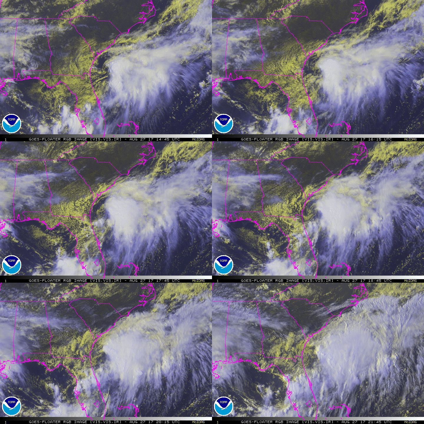
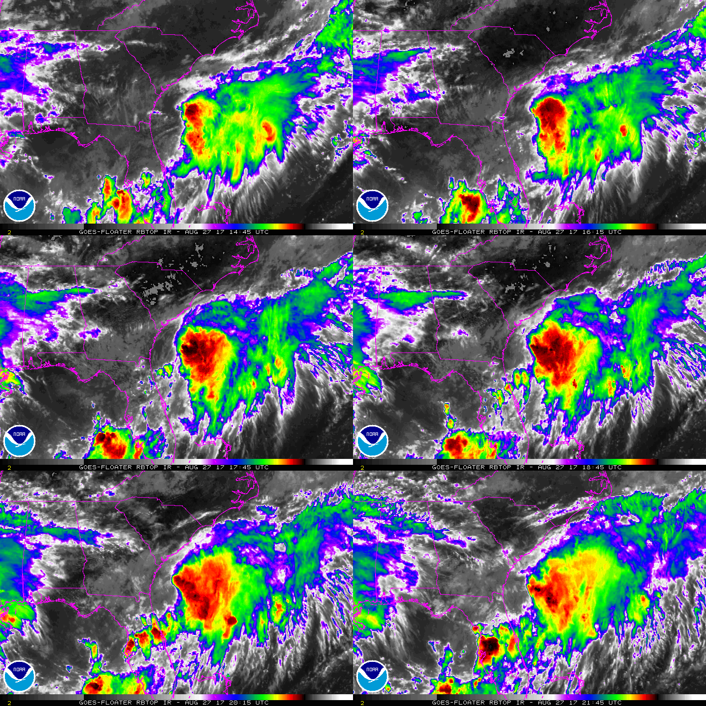
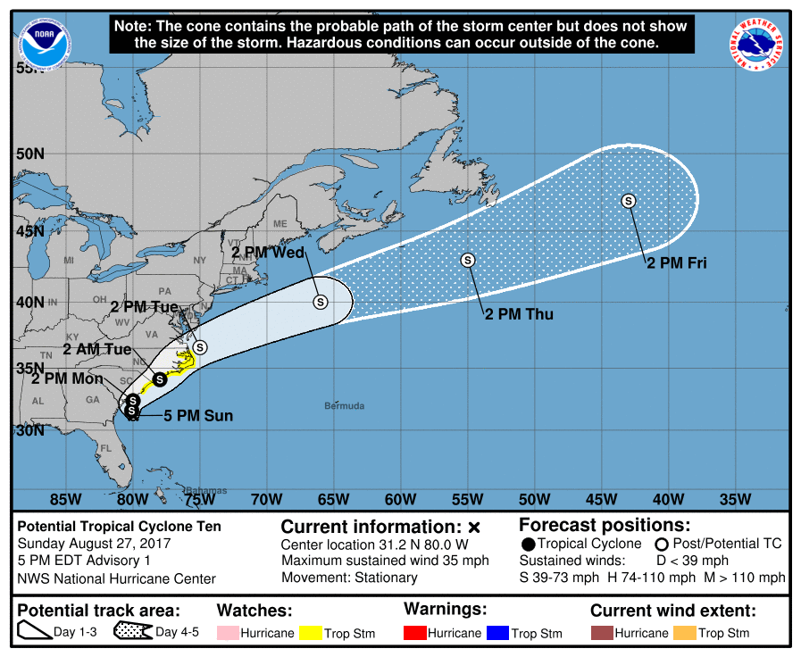
升格"潛在熱帶氣旋10L",預計24H後將橫掃美國東岸。
000
WTNT45 KNHC 272047
TCDAT5

Potential Tropical Cyclone Ten Discussion Number   1
NWS National Hurricane Center Miami FL       AL102017
500 PM EDT Sun Aug 27 2017

Convection associated with the broad area of low pressure located
east of the Georgia coast has increased markedly today. Visibile
satellite imagery shows multiple low-level swirls rotating around a
mean center, but ASCAT data earlier today showed that the
circulation was not yet well-defined. The ASCAT data and buoy
observations indicate that the initial intensity is 30 kt, and buoy
data suggest the central pressure is around 1007 mb. While the
system is expected to remain sheared, it has a high chance of
becoming a tropical depression or tropical storm before it becomes
baroclinic in about 48 hours. Given that, and the potential for
this system to bring tropical storm conditions to the coast from
northern South Carolina through North Carolina, advisories are
being initiated on this system as a Potential Tropical Cyclone.

The system is currently moving little in a region of weak steering,
but should begin to move slowly northward and then quickly
accelerate northeastward ahead of a mid-latitude trough moving into
the mid-Atlantic states. The NHC forecast follows the trend of the
global models keeping the low center near the coast, but as usual
there is more uncertainty than usual in the track forecast for a
weak/developing system. After the system moves into the western
Atlantic, it should continue accelerating east-northeastward ahead
of the upper trough through the end of the period.

Despite the sheared envirionment, the system should be able to
intensify a little via diabatic processes before it intensifies
further as it undergoes a more substantial baroclinic
intensification at 48 hours and beyond. The NHC intensity forecast
follows the intensity consensus through 36 hours and then follows
the trend of the global model guidance and guidance from the NOAA
Ocean Prediction Center.

Although the potential impacts are within 36 hours, given the
uncertainty in whether tropical storm force winds will occur on land
in northeastern South Caroilna and southeastern North Carolina,
south, a tropical storm watch has been issued for these areas.
Note that north of Duck, North Carolina, hazards from this system
will be handled with non-tropical products issued by local National
Weather Service offices.


FORECAST POSITIONS AND MAX WINDS

INIT  27/2100Z 31.2N  80.0W   30 KT  35 MPH...POTENTIAL TROP CYCLONE
12H  28/0600Z 31.6N  80.1W   35 KT  40 MPH...TROPICAL CYCLONE
24H  28/1800Z 32.4N  80.0W   35 KT  40 MPH
36H  29/0600Z 34.1N  78.0W   35 KT  40 MPH...INLAND
48H  29/1800Z 36.6N  75.0W   45 KT  50 MPH...POST-TROPICAL
72H  30/1800Z 40.0N  66.0W   55 KT  65 MPH...POST-TROP/EXTRATROP
96H  31/1800Z 43.0N  55.0W   60 KT  70 MPH...POST-TROP/EXTRATROP
120H  01/1800Z 47.0N  43.0W   50 KT  60 MPH...POST-TROP/EXTRATROP

$$
Forecaster Brennan
205404_5day_cone_no_line_and_wind.png rgb-animated (8).gif rbtop-animated (14).gif


回復

使用道具 舉報

簽到天數: 11 天

[LV.3]偶爾看看II

Meranti|2017-8-29 11:02 來自手機 | 顯示全部樓層
霧峰追風者 發表於 2017-8-28 06:38
升格"潛在熱帶氣旋10L",預計24H後將橫掃美國東岸。

我想問一下什麼叫潛在熱帶氣旋
回復

使用道具 舉報

簽到天數: 601 天

[LV.9]以壇為家II

霧峰追風者|2017-8-30 06:34 | 顯示全部樓層
Meranti 發表於 2017-8-29 11:02
我想問一下什麼叫潛在熱帶氣旋

大概意思是,從今年2017年5月15日起,NWS(包括NHC和CPHC)將對靠近陸地並構成威脅的可能發展成熱帶氣旋的擾動(原文是“48小時內可能對陸地造成熱帶風暴或颶風級別的影響“)直接編號。此擾動會被稱為"潛熱熱帶氣旋",並且按照熱帶氣旋的方式發報,其編號將與正式的熱帶氣旋合併統計(例如颶風1號- >熱帶低壓2號- >潛在熱帶氣旋3號- >熱帶風暴4號...)遠離陸地不構成任何威脅(也不引起風暴潮)熱帶的擾動的處理方式不變。
回復

使用道具 舉報

快速回覆
您需要登錄後才可以回帖 登錄 | 立即加入

本版積分規則

0908morakot

    主題

    帖子

    69萬

    積分

    12級[颶風Hurricane]

    Rank: 12Rank: 12Rank: 12

12級[颶風Hurricane]

發訊息

本平台僅供學術討論之用,預報應以氣象局為準

威普網站虛擬主機贊助公司

臺灣第一個天氣類型社群平台 即時天氣資訊、精準颱風動態

線上客服
FB傳送訊息
廣告行銷
精準行銷 物超所值
官方粉專
發佈 快速回復 返回頂部 返回列表