開啟輔助訪問
 找回密碼
 立即加入

11E 風切干擾 無緣命名

簽到天數: 601 天

[LV.9]以壇為家II

2017-8-1 08:06 | 顯示全部樓層
本帖最後由 霧峰追風者 於 2017-12-12 06:36 編輯

  熱帶低壓  
編號:08 E
名稱:
11e2017-08-04-2015z.png
  基本資料  
擾動編號日期:2017 08 01 06
升格日期  :2017 08 05 03
撤編日期  :2017 08 07 11
登陸地點  :

  巔峰時期資料  
近中心最強風速 :30  kt
海平面最低氣壓 :1004 百帕


  過去路徑圖  
1920px-11E_2017_track.png
  擾動編號資料  
91E.INVEST.15kts.1006mb.9.5N.90W

20170731.2330.goes13.x.ir1km_bw.91EINVEST.25kts-1009mb-95N-900W.74pc.jpg

NHC :20%
1. Disorganized showers and thunderstorms located over the far eastern
Pacific Ocean are associated with a tropical wave.  Environmental
conditions appear conducive for some slow development of this
disturbance during the next several days while it moves west-
northwestward at 10 to 15 mph south of the coast of Mexico.
Upper-level winds will likely become unfavorable for development by
Friday.
* Formation chance through 48 hours...low...20 percent.
* Formation chance through 5 days...medium...40 percent.

two_pac_2d1.png


以上資料來自:NHC、颱風論壇整理製作

評分

參與人數 1水氣能量 +15 收起 理由
t02436 + 15

查看全部評分

回復

使用道具 舉報

簽到天數: 601 天

[LV.9]以壇為家II

霧峰追風者|2017-8-4 19:36 | 顯示全部樓層
NHC 展望提升至60%
1. Showers and thunderstorms associated with an area of low pressure
located a few hundred miles southwest of Manzanillo, Mexico,
continue to show signs of organization.  Some additional development
is possible today before environmental conditions become hostile by
the weekend. This disturbance should move west-northwestward at
about 15 mph for the next few days.
* Formation chance through 48 hours...medium...60 percent.
* Formation chance through 5 days...medium...60 percent.
two_pac_2d1 (1).png rbtop-animated (2).gif


回復

使用道具 舉報

簽到天數: 601 天

[LV.9]以壇為家II

霧峰追風者|2017-8-4 23:42 | 顯示全部樓層
本帖最後由 霧峰追風者 於 2017-8-4 23:57 編輯

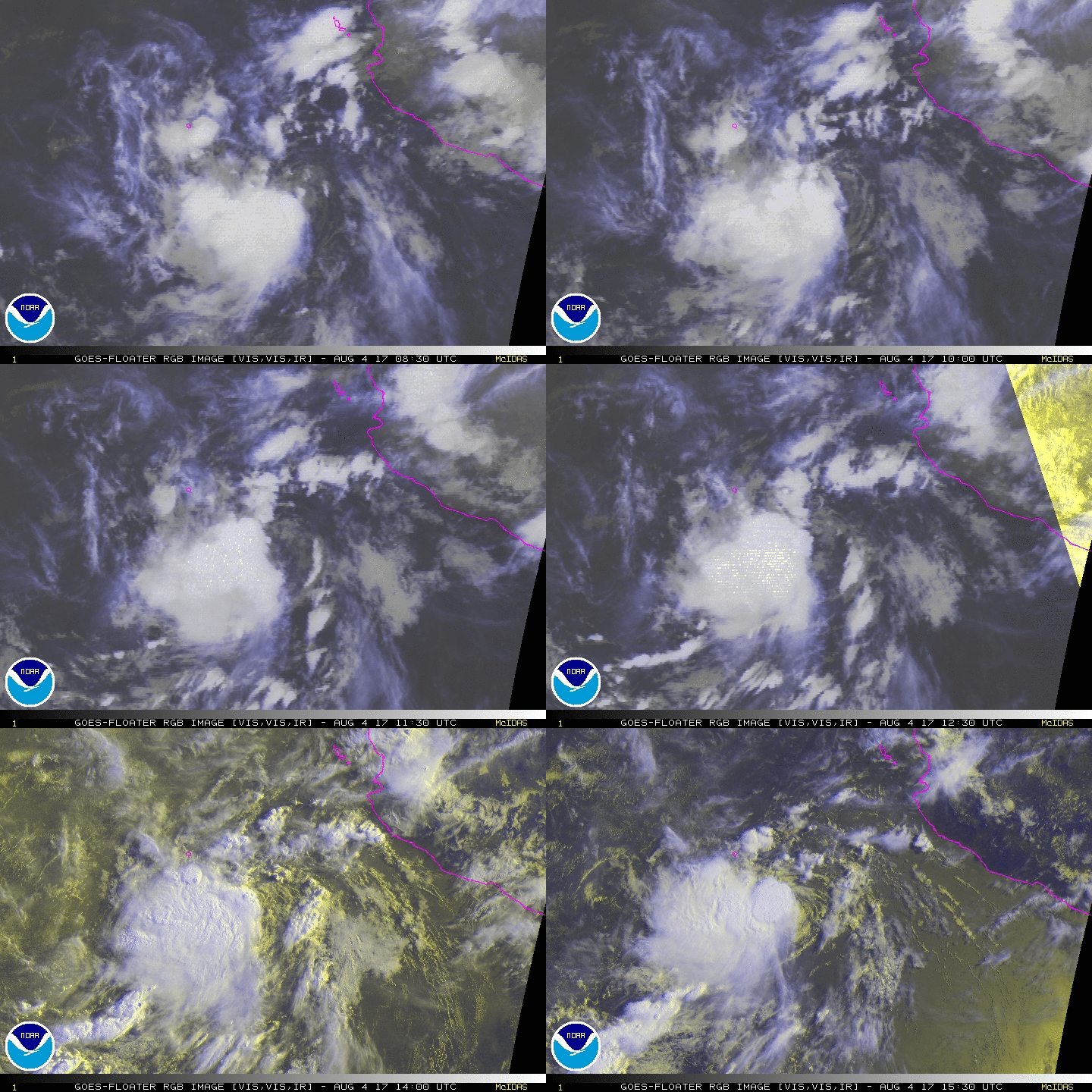
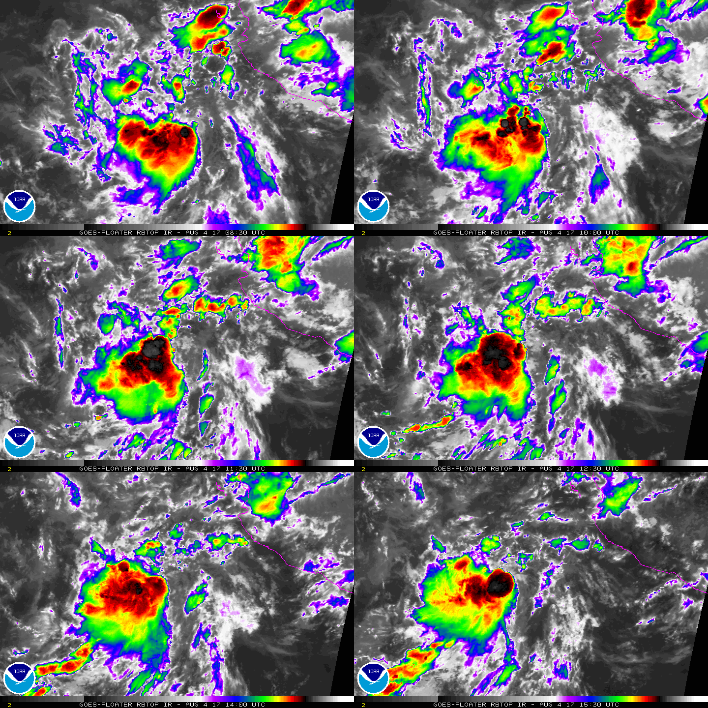
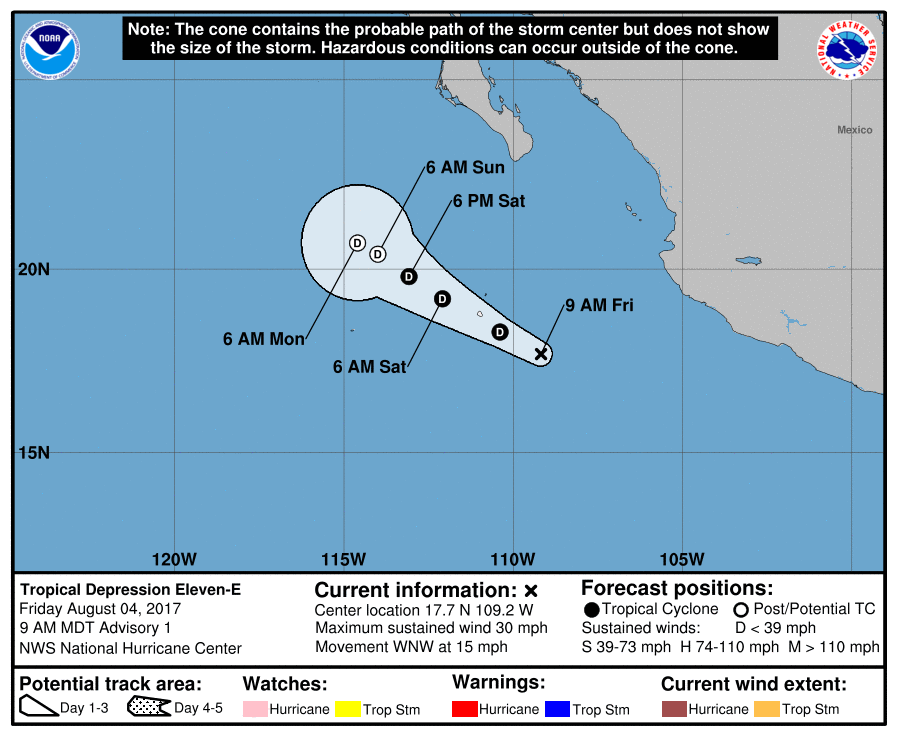
NHC 又突然升格,編號"11E",不過不看好命名...
000
WTPZ41 KNHC 041443
TCDEP1

Tropical Depression Eleven-E Discussion Number   1
NWS National Hurricane Center Miami FL       EP112017
900 AM MDT Fri Aug 04 2017

First-light 1-minute visible imagery from GOES-16 confirms that the
low pressure area located a few hundred miles west-southwest of
Manzanillo, Mexico, has a well-defined low-level center.  Deep
convection has persisted since yesterday, mainly in the western
portion of the circulation, and Dvorak Final-T numbers from TAFB and
SAB are a consensus 1.5.  Based on these factors, the system has
been classified as a 25-kt tropical depression.

The depression is strongly sheared from the northeast due to an
upper-level high centered over northern Mexico. The shear is not
expected to relax during the next few days, and this should keep the
system weak.  In fact, I currently have no guidance that suggests
that the system will ever become a tropical storm.  The intensity
forecast therefore shows no change in intensity until the system
becomes post-tropical in a couple of days due to the persistent
shear and a drier environment.

The depression is moving toward the west-northwest (300 degrees) at
13 kt, though the initial speed is somewhat uncertain since the
center has only recently become well defined.  Since the cyclone is
forecast to remain weak, it should be steered primarily by the low-
to mid-level flow associated with the subtropical ridge.  The GFS
and ECMWF are in fairly good agreement that this will keep the
depression moving in a near straight-line heading for the next day
or two.  After that, the forward speed of the cyclone should slow
down substantially while it dissipates early next week. The track
forecast is very close to the model consensus, TVCN.


FORECAST POSITIONS AND MAX WINDS

INIT  04/1500Z 17.7N 109.2W   25 KT  30 MPH
12H  05/0000Z 18.3N 110.4W   25 KT  30 MPH
24H  05/1200Z 19.2N 112.1W   25 KT  30 MPH
36H  06/0000Z 19.8N 113.1W   25 KT  30 MPH
48H  06/1200Z 20.4N 114.0W   20 KT  25 MPH...POST-TROP/REMNT LOW
72H  07/1200Z 20.7N 114.6W   20 KT  25 MPH...POST-TROP/REMNT LOW
96H  08/1200Z...DISSIPATED

$$
Forecaster Zelinsky
144826_5day_cone_no_line_and_wind.png rgb-animated (1).gif rbtop-animated (3).gif

評分

參與人數 1水氣能量 +10 收起 理由
t02436 + 10

查看全部評分

回復

使用道具 舉報

簽到天數: 498 天

[LV.9]以壇為家II

...|2017-8-6 11:07 | 顯示全部樓層
000
WTPZ31 KNHC 052037
TCPEP1

BULLETIN
Post-Tropical Cyclone Eleven-E Advisory Number   6
NWS National Hurricane Center Miami FL       EP112017
300 PM MDT Sat Aug 05 2017

...DEPRESSION BECOMES A REMNANT LOW...
...THIS IS THE LAST ADVISORY...


SUMMARY OF 300 PM MDT...2100 UTC...INFORMATION
----------------------------------------------
LOCATION...20.3N 111.7W
ABOUT 115 MI...180 KM NNW OF SOCORRO ISLAND
MAXIMUM SUSTAINED WINDS...30 MPH...45 KM/H
PRESENT MOVEMENT...NNW OR 335 DEGREES AT 7 MPH...11 KM/H
MINIMUM CENTRAL PRESSURE...1009 MB...29.80 INCHES
NHC發出FW 雲系已經潰散預計中心將繼續緩慢向北減弱消散

回復

使用道具 舉報

快速回覆
您需要登錄後才可以回帖 登錄 | 立即加入

本版積分規則

本平台僅供學術討論之用,預報應以氣象局為準

威普網站虛擬主機贊助公司

臺灣第一個天氣類型社群平台 即時天氣資訊、精準颱風動態

線上客服
FB傳送訊息
廣告行銷
精準行銷 物超所值
官方粉專
發佈 快速回復 返回頂部 返回列表