開啟輔助訪問
 找回密碼
 立即加入

10E.Irwin FW 逐漸北上

簽到天數: 474 天

[LV.9]以壇為家II

2017-7-20 13:37 | 顯示全部樓層
提示: 作者被禁止或刪除 內容自動屏蔽
回復

使用道具 舉報

簽到天數: 474 天

[LV.9]以壇為家II

劉瑞益@FB|2017-7-21 06:11 | 顯示全部樓層
提示: 作者被禁止或刪除 內容自動屏蔽
回復

使用道具 舉報

簽到天數: 3291 天

[LV.Master]伴壇終老

t02436|2017-7-23 00:22 | 顯示全部樓層
NHC升格10E,正式成為東太七月第六個被編正式號的熱帶系統。
000
WTPZ45 KNHC 221455
TCDEP5

Tropical Depression Ten-E Discussion Number   1
NWS National Hurricane Center Miami FL       EP102014
900 AM MDT Sat Jul 22 2017

I thought there was no more room for another cyclone in the eastern
Pacific basin, but nature managed to produce another one.
The
disturbance that NHC has been monitoring for several days has
finally developed enough circulation and convection to be classified
as a tropical depression, the sixth cyclone that has formed in the
month of July.


The center is located on the northern edge of a circular mass of
deep convection and, based of an average of Dvorak numbers, it is
being assigned an initial intensity of 30 kt.  The depression is in
between TS Greg and TD 9-E, and the environment is not ideal for
strengthening. However, most of the global models show a decrease
of the shear in the next few days, and this will allow some
intensification.


The depression is trapped south of a subtropical ridge and is moving
toward the west at about 6 kt.  The nose of the ridge is forecast to
amplify westward, and this flow pattern will likely force the
cyclone on a slow west and then west-southwest track during the next
five days. Most of the guidance agree with this solution, but one
must use caution since there could be some interaction with Tropical
Depression Nine-E which increases the forecast uncertainty.


FORECAST POSITIONS AND MAX WINDS

INIT  22/1500Z 14.7N 112.8W   30 KT  35 MPH
12H  23/0000Z 14.8N 113.8W   35 KT  40 MPH
24H  23/1200Z 15.0N 115.0W   40 KT  45 MPH
36H  24/0000Z 15.0N 116.0W   45 KT  50 MPH
48H  24/1200Z 15.0N 117.0W   55 KT  65 MPH
72H  25/1200Z 15.0N 119.5W   60 KT  70 MPH
96H  26/1200Z 14.5N 122.0W   60 KT  70 MPH
120H  27/1200Z 13.5N 124.0W   60 KT  70 MPH

$$
Forecaster Avila

150008_5day_cone_with_line.png

rbtop-animated.gif

回復

使用道具 舉報

簽到天數: 474 天

[LV.9]以壇為家II

劉瑞益@FB|2017-7-23 18:11 | 顯示全部樓層
提示: 作者被禁止或刪除 內容自動屏蔽
回復

使用道具 舉報

簽到天數: 3291 天

[LV.Master]伴壇終老

t02436|2017-7-25 17:29 | 顯示全部樓層
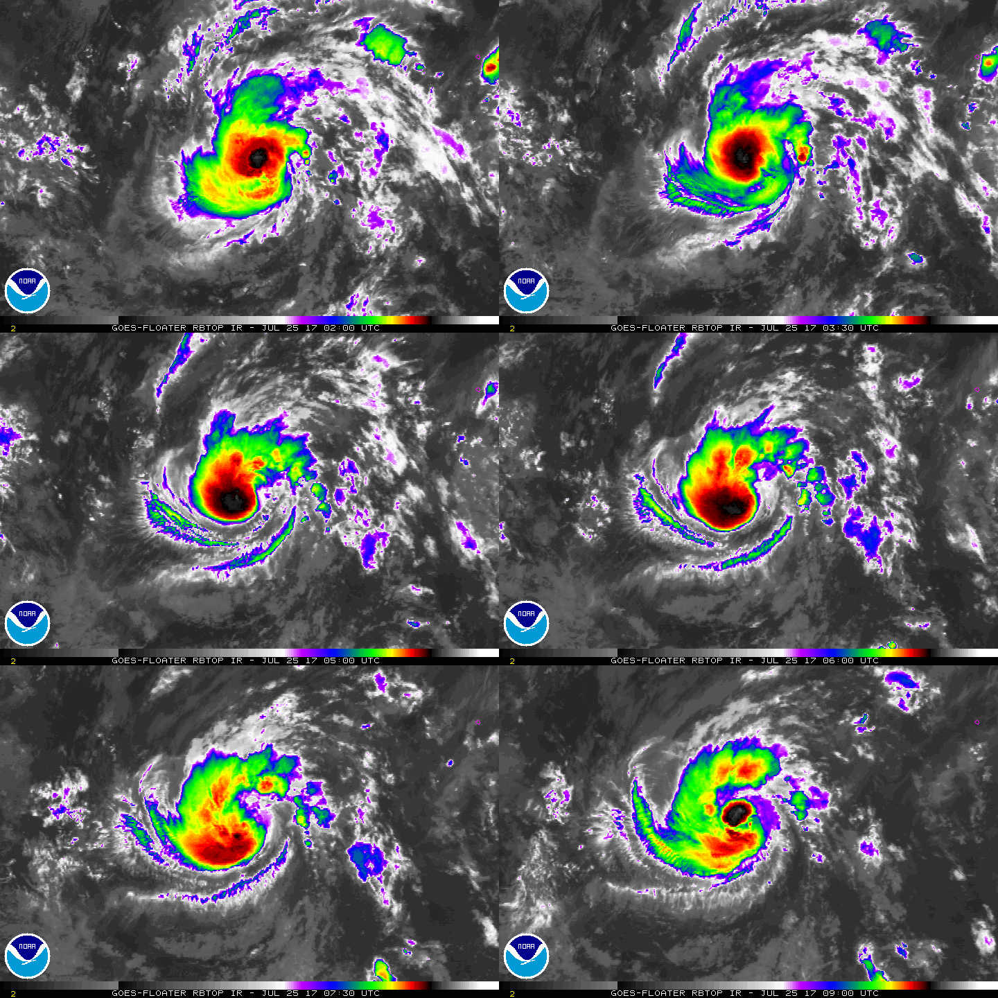
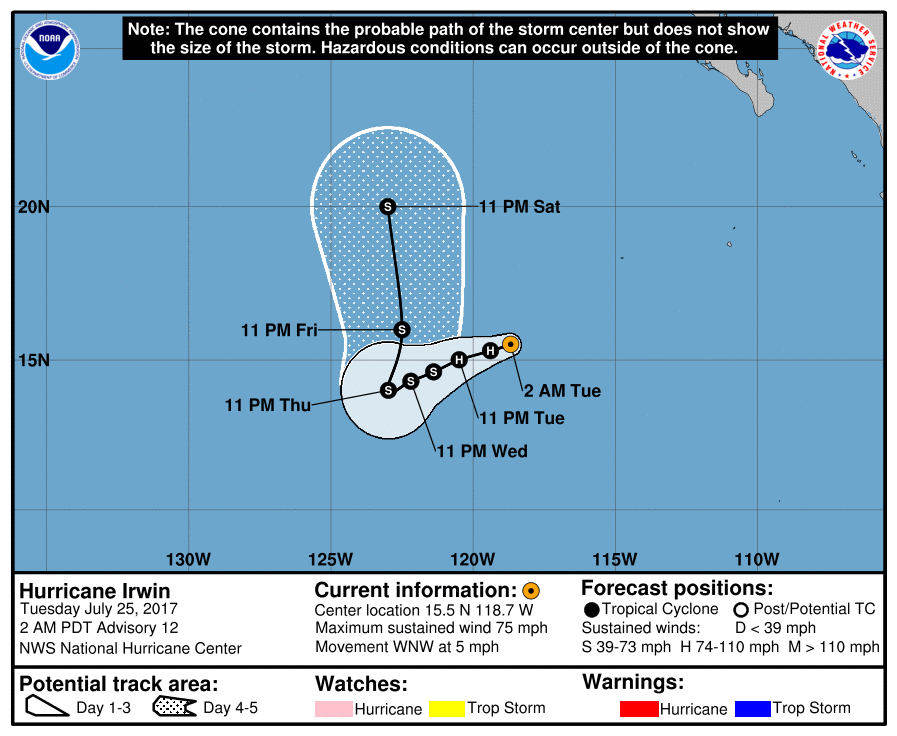
09Z報站上颶風,東太藤原組合將緊接著西太上映,目前預測3天後隨著Hilary北上,Irwin將會被拉上來,甚至有可能跟隔壁棚庫拉一樣的下場。
000
WTPZ45 KNHC 250858
TCDEP5

Hurricane Irwin Discussion Number  12
NWS National Hurricane Center Miami FL       EP102017
200 AM PDT Tue Jul 25 2017

Deep convection associated with Irwin now wraps almost all of the
way around the center, and there have been occasional hints of a
eye in microwave and conventional satellite imagery.  Subjective
satellite estimates from TAFB and SAB are just below hurricane
strength, while several objective estimates, including the CIMSS
satellite consensus, are above hurricane strength. With the attempts
at eye formation, the initial intensity will lean toward the higher
intensity estimates, and thus Irwin is upgraded to a hurricane.

The initial motion is a little more northward than before at 300/4.
A slow westward motion is forecast today as a weak mid-level ridge
remains in place to the north of the storm.  A west-southwestward
motion is expected between 24-72 h as Hurricane Hilary approaches
from the east.  After that, Irwin is expected to undergo an binary
interaction with Hilary, with the most likely result for Irwin
being a generally northward motion around the eastern semicircle of
Hilary.  The details of this are still uncertain, with the ECMWF
and Canadian models merging the two cyclones before 120 h, while
the GFS and UKMET keep them separate until after 120 h.  The new
track forecast is similar to the previous forecast through 72 h.
After that, it leans towards the GFS/UKMET in keeping the cyclone
separate and accelerating Irwin around the eastern side of Hilary.

Little change in strength is likely for the next 24 h.  After that,
increasing shear associated with the outflow of Hilary is likely to
cause Irwin to weaken
, although there is considerable spread in the
guidance as to how much shear and how much weakening.  By the end
of the forecast period, cooler water along the forecast track and
proximity to Hilary should cause additional weakening.  The new
forecast track is a slight adjustment of the previous track.  An
alternative intensity scenario is that Irwin dissipates as it is
absorbed by Hilary before 120 h.


FORECAST POSITIONS AND MAX WINDS

INIT  25/0900Z 15.5N 118.7W   65 KT  75 MPH
12H  25/1800Z 15.3N 119.4W   65 KT  75 MPH
24H  26/0600Z 15.0N 120.5W   65 KT  75 MPH
36H  26/1800Z 14.6N 121.4W   60 KT  70 MPH
48H  27/0600Z 14.3N 122.2W   55 KT  65 MPH
72H  28/0600Z 14.0N 123.0W   55 KT  65 MPH
96H  29/0600Z 16.0N 122.5W   55 KT  65 MPH
120H  30/0600Z 20.0N 123.0W   50 KT  60 MPH

$$
Forecaster Beven
090314_5day_cone_with_line.png

rbtop-animated.gif
回復

使用道具 舉報

簽到天數: 3291 天

[LV.Master]伴壇終老

t02436|2017-7-31 00:50 | 顯示全部樓層
紀錄一下,已經開始北上,但風速仍有55節。
000
WTPZ45 KNHC 301436
TCDEP5

Tropical Storm Irwin Discussion Number  33
NWS National Hurricane Center Miami FL       EP102017
800 AM PDT Sun Jul 30 2017

Even though Irwin is crossing the 26 deg C isotherm, it does not
appear to be weakening yet.  In fact, recent microwave data indicate
the tropical storm has a mid-level eye, which has occasionally
appeared in geostationary satellite images.  The system is still
producing a fair amount of deep convection, especially to the south
of the center.  The latest Dvorak CI-numbers from TAFB and SAB are
3.5/55 kt and accordingly, the initial intensity is set a bit higher
to 55 kt.  This wind speed estimate is also in agreement with ASCAT
data from several hours ago that showed maximum winds near 50 kt.

Despite the recent increase in intensity, Irwin is expected to begin
weakening soon as it moves over even cooler waters and into a drier
and more stable air mass.  The storm is likely to become a remnant
low in 36 to 48 hours when it will be over SSTs near 22 deg C.  Most
of the global models show the remnant low dissipating in 4 to 5
days.  The NHC intensity forecast follows the trend of the guidance,
and it is largely unchanged from the previous prediction.

Irwin is moving north-northwestward, or 345 degrees, at 8 kt.  The
system is embedded in south-southeasterly flow in the wake of
Hilary, and it is expected to remain in this steering flow for
another day or two.  Once Irwin becomes a remnant low, the shallow
system is expected to turn a little to the left and slow down as it
becomes steered by the low-level flow.  The NHC track forecast is
adjusted a little to the north and east of the previous one, to come
into better agreement with the latest consensus models.

FORECAST POSITIONS AND MAX WINDS

INIT  30/1500Z 17.9N 125.4W   55 KT  65 MPH
12H  31/0000Z 19.4N 126.1W   50 KT  60 MPH
24H  31/1200Z 21.7N 127.3W   40 KT  45 MPH
36H  01/0000Z 23.9N 128.6W   35 KT  40 MPH
48H  01/1200Z 25.7N 130.0W   25 KT  30 MPH...POST-TROP/REMNT LOW
72H  02/1200Z 27.9N 132.0W   20 KT  25 MPH...POST-TROP/REMNT LOW
96H  03/1200Z 29.0N 133.2W   15 KT  15 MPH...POST-TROP/REMNT LOW
120H  04/1200Z...DISSIPATED

$$
Forecaster Cangialosi

144200_5day_cone_with_line_and_wind.png

rbtop-animated.gif


回復

使用道具 舉報

簽到天數: 2141 天

[LV.Master]伴壇終老

周子堯@FB|2017-8-1 14:43 | 顯示全部樓層
海水OHC含量降低,發展不利,將減弱消散!
SST.GIF

024349_5day_cone_no_line_and_wind.png

rbtop_lalo-animated.gif


回復

使用道具 舉報

簽到天數: 498 天

[LV.9]以壇為家II

...|2017-8-2 12:31 | 顯示全部樓層
000
WTPZ35 KNHC 012037
TCPEP5

BULLETIN
Post-Tropical Cyclone Irwin Advisory Number  42
NWS National Hurricane Center Miami FL       EP102017
200 PM PDT Tue Aug 01 2017

...IRWIN NOW A REMNANT LOW...
...THIS IS THE LAST ADVISORY...


SUMMARY OF 200 PM PDT...2100 UTC...INFORMATION
----------------------------------------------
LOCATION...26.6N 129.7W
ABOUT 1265 MI...2040 KM WNW OF THE SOUTHERN TIP OF BAJA CALIFORNIA
MAXIMUM SUSTAINED WINDS...35 MPH...55 KM/H
PRESENT MOVEMENT...NNW OR 330 DEGREES AT 8 MPH...13 KM/H
MINIMUM CENTRAL PRESSURE...1007 MB...29.74 INCHES


WATCHES AND WARNINGS
--------------------
There are no coastal watches or warnings in effect.


DISCUSSION AND 48-HOUR OUTLOOK
------------------------------
At 200 PM PDT (2100 UTC), the center of Post-Tropical Cyclone Irwin
was located near latitude 26.6 North, longitude 129.7 West. The
post-tropical cyclone is moving toward the north-northwest near 8
mph (13 km/h), and this motion is expected to continue
today.

Maximum sustained winds are near 35 mph (55 km/h) with higher gusts.
Dissipation is expected during the next day or so.

The estimated minimum central pressure is 1007 mb (29.74 inches).

HAZARDS AFFECTING LAND
----------------------
None.


NEXT ADVISORY
-------------
This is the last public advisory issued by the National Hurricane
Center on this system. For additional information on the remnant low
please see High Seas Forecasts issued by the National Weather
Service, under AWIPS header NFDHSFEPI, WMO header FZPN02 KWBC, and
on the web at http://www.opc.ncep.noaa.gov/shtml/NFDHSFEPI.shtml.


$$
Forecaster Avila

204200_5day_cone_no_line_and_wind.png
NHC已經發出FW 將繼續向西北減弱消散
回復

使用道具 舉報

快速回覆
您需要登錄後才可以回帖 登錄 | 立即加入

本版積分規則

本平台僅供學術討論之用,預報應以氣象局為準

威普網站虛擬主機贊助公司

臺灣第一個天氣類型社群平台 即時天氣資訊、精準颱風動態

線上客服
FB傳送訊息
廣告行銷
精準行銷 物超所值
官方粉專
發佈 快速回復 返回頂部 返回列表