開啟輔助訪問
 找回密碼
 立即加入

22E(16L).Otto 少見由大西洋跨洋至東太的熱帶氣旋

簽到天數: 588 天

[LV.9]以壇為家II

Meow|2016-11-24 22:53 | 顯示全部樓層
突然發展出很好的風眼,看看能否在3小時後爭取到MH登陸。

FORECAST POSITIONS AND MAX WINDS

INIT  24/1500Z 11.0N  83.4W   95 KT 110 MPH
12H  25/0000Z 10.8N  84.8W   60 KT  70 MPH...INLAND
24H  25/1200Z 10.3N  87.4W   50 KT  60 MPH...OVER WATER
36H  26/0000Z  9.8N  89.7W   40 KT  45 MPH
48H  26/1200Z  9.5N  92.5W   40 KT  45 MPH
72H  27/1200Z  9.0N  98.5W   40 KT  45 MPH
96H  28/1200Z 10.0N 102.5W   35 KT  40 MPH
120H  29/1200Z 11.5N 104.5W   25 KT  30 MPH...POST-TROP/REMNT LOW
143439W5_NL_sm.gif
20161124.1415.goes-13.vis.1km.16L.OTTO.95kts.975mb.11N.82.9W.100pc.jpg
回復

使用道具 舉報

簽到天數: 3291 天

[LV.Master]伴壇終老

t02436|2016-11-25 08:28 | 顯示全部樓層
Otto已經於18Z以95節、975百帕的強度登陸尼加拉瓜,無緣挑戰MH。
000
WTNT41 KNHC 242047
TCDAT1

HURRICANE OTTO DISCUSSION NUMBER  16
NWS NATIONAL HURRICANE CENTER MIAMI FL       AL162016
400 PM EST THU NOV 24 2016

Satellite imagery and radar data from Nicaragua indicate that
Hurricane Otto made landfall at approximately 1800 UTC today along
the extreme southern coast of Nicaragua, just north of the town
of San Juan de Nicaragua.
The peak intensity at the time of landfall
was estimated to be at least 95 kt and the central pressure was
estimated at 975 mb. This makes Otto the southernmost landfalling
hurricane in Central America on record.


The initial motion estimate is 270/10 kt. Otto is located inland
over extreme southern Nicaragua, just north of the border with Costa
Rica. Easterly steering flow on the south side of a deep-layer ridge
located over the northwestern Caribbean Sea and southern Mexico is
expected to keep Otto or its remnants moving in a westward to
west-southwestward direction throughout the forecast period. The
global and regional models are in good agreement on this track
scenario, and only a slight northward adjustment was made to the
previous forecast track, mainly due to the more northward initial
position of Otto.

Otto is forecast to weaken rapidly while the hurricane moves farther
inland over the rough terrain of southern Nicaragua and northern
Costa Rica tonight. Otto is expected to weaken to a tropical storm
by the time it emerges over the eastern North Pacific in about 12 h,
and maintain that intensity during the 24-96 hour period. The ECMWF,
UKMET, and Canadian models continue to weaken Otto throughout the
forecast period, especially after 48 hours when the cyclone is
forecast to interact with a dry Gulf of Tehuantepec gap-wind event.
Erosion of the inner-core convection and wind field is expected from
this negative interaction, resulting in dissipation of Otto by
48-72 h. In contrast, the GFS model keeps the gap-wind event away
from Otto and strengthens the cyclone back to hurricane status by
48 h and beyond. For now, the NHC official intensity forecast will
remain similar to the previous advisory, and more closely follows
the Decay-SHIPS intensity model, which is well below all of the
other intensity forecast models.

The primary threat from Otto is going to be torrential rainfall,
which will result in dangerous flooding and mudslides. Reports of
mudslides across northern Costa Rica have already been received from
amateur radio operators in that area.

FORECAST POSITIONS AND MAX WINDS

INIT  24/2100Z 11.0N  84.3W   85 KT 100 MPH...INLAND
12H  25/0600Z 10.7N  86.0W   60 KT  70 MPH...OVER WATER
24H  25/1800Z 10.2N  88.5W   55 KT  65 MPH
36H  26/0600Z  9.8N  91.1W   45 KT  50 MPH
48H  26/1800Z  9.5N  93.9W   45 KT  50 MPH
72H  27/1800Z  9.4N 100.0W   45 KT  50 MPH
96H  28/1800Z 10.5N 103.5W   40 KT  45 MPH
120H  29/1800Z 12.1N 105.1W   25 KT  30 MPH...POST-TROP/REMNT LOW

$$
Forecaster Stewart

233820W_sm.gif

rbtop-animated.gif

vis-animated.gif
回復

使用道具 舉報

簽到天數: 588 天

[LV.9]以壇為家II

Meow|2016-11-25 11:47 | 顯示全部樓層
NHC公告09Z改以太平洋區塊發報,不改名但編號改為EP222016(22E)。
回復

使用道具 舉報

簽到天數: 3291 天

[LV.Master]伴壇終老

t02436|2016-11-25 14:40 | 顯示全部樓層
通知09Z改編號報文
000
WTNT41 KNHC 250254
TCDAT1

TROPICAL STORM OTTO DISCUSSION NUMBER  17
NWS NATIONAL HURRICANE CENTER MIAMI FL       AL162016
900 PM CST THU NOV 24 2016

Radar data from Las Nubes, Nicaragua, indicate that the core of Otto
has remained well organized since landfall, with an eye still
discernible.  On the other hand, the convective clouds associated
with the cyclone have warmed considerably since landfall.  There
have been no surface observations from the core, so the initial
intensity is reduced to a somewhat uncertain 60 kt based on the
decay in the satellite appearance.

The initial motion estimate is 265/11.  Otto is located over
northwestern Costa Rica and should emerge into the Pacific during
the next few hours.  Easterly steering flow on the south side of a
deep-layer ridge located over the northwestern Caribbean Sea and
southern Mexico is expected to keep Otto moving in a westward to
west-southwestward direction for the next 72 hours or so.  After
that time, the cyclone or its remnants are expected to reach the
end of the ridge and turn northwestward.  The new forecast track is
similar to the previous track through 72 hours, then is shifted a
little to the left of the track based on a shift in the consensus
models.

During the first 36 hours over the Pacific, Otto is likely to be
over warm sea surface temperatures in an environment of moderate to
strong easterly vertical wind shear.  The intensity forecast during
this time will show a slow weakening in agreement with the previous
forecast due to the uncertainties in the strength of the shear.
However, given the level of organization it would not be surprising
if some intensification occurred.  Around 48 hours, the cyclone is
likely to encounter cooler sea surface temperatures which should
cause a faster weakening.  From 72-120 hours, Otto is expected to
move over warmer water with decreasing shear at the same time it
encounters a much drier air mass.  The intensity forecast uses the
premise that the dry air will cause the system to decay and thus
calls for Otto to be a remnant low by 120 hours.  It should be
noted, though, the the intensity forecast after 48 hours remains
near the lower edge of the guidance.

The primary threat from Otto will continue to be torrential
rainfall, which will result in dangerous flooding and mudslides.

Since Otto has maintained itself as a tropical cyclone all the way
across the land mass of Central America, based on National Weather
Service and World Meteorological Organization protocols, it will
retain the name Otto when it moves over the eastern Pacific in a few
hours. Product headers will change to eastern Pacific headers
beginning with the next complete advisory at 0900 UTC.
The
intermediate advisory at 0600 UTC will be issued under an Atlantic
header.  The ATCF identifier will change from AL162016 to EP222016
at 0900 UTC.


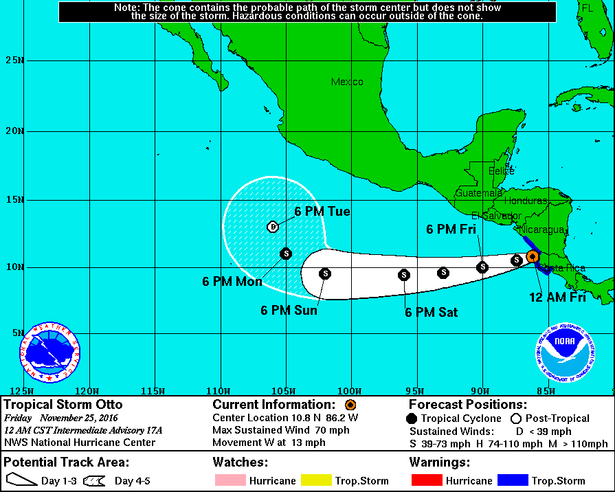
FORECAST POSITIONS AND MAX WINDS

INIT  25/0300Z 10.9N  85.6W   60 KT  70 MPH...INLAND
12H  25/1200Z 10.5N  87.4W   55 KT  65 MPH...OVER THE PACIFIC
24H  26/0000Z 10.0N  90.0W   55 KT  65 MPH
36H  26/1200Z  9.6N  93.0W   50 KT  60 MPH
48H  27/0000Z  9.4N  96.0W   45 KT  50 MPH
72H  28/0000Z  9.5N 102.0W   45 KT  50 MPH
96H  29/0000Z 11.0N 105.0W   40 KT  45 MPH
120H  30/0000Z 13.0N 106.0W   30 KT  35 MPH...POST-TROP/REMNT LOW

$$
Forecaster Beven

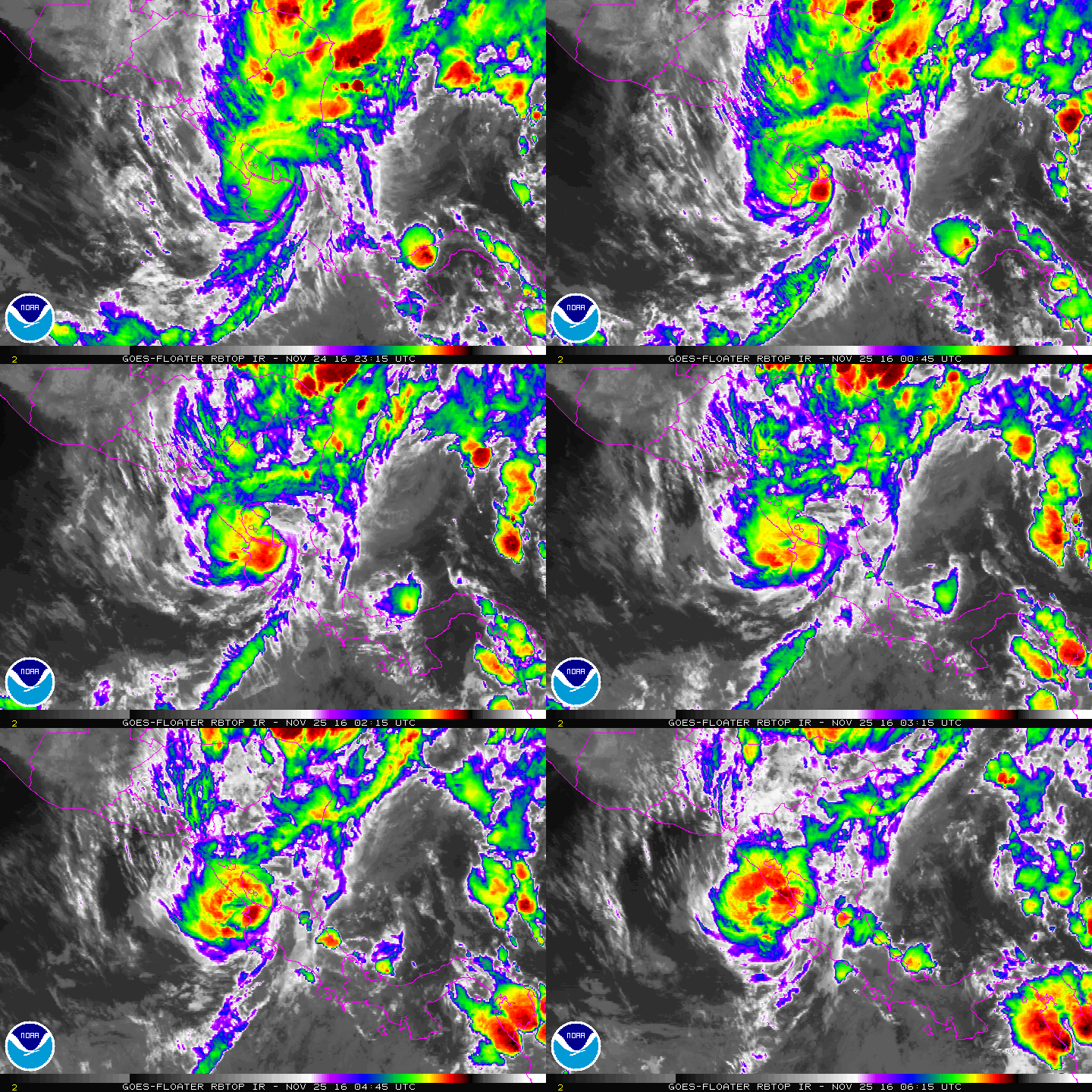
06Z已經進入東太平洋
BULLETIN
TROPICAL STORM OTTO INTERMEDIATE ADVISORY NUMBER  17A
NWS NATIONAL HURRICANE CENTER MIAMI FL       AL162016
1200 AM CST FRI NOV 25 2016

...CENTER OF OTTO NOW OVER THE EASTERN PACIFIC OCEAN...
...DANGEROUS FLOODING RAINS CONTINUING OVER PORTIONS OF COSTA RICA
AND NICARAGUA...


SUMMARY OF 1200 AM CST...0600 UTC...INFORMATION
-----------------------------------------------
LOCATION...10.8N 86.2W
ABOUT 55 MI...90 KM WNW OF LIBERIA COSTA RICA
MAXIMUM SUSTAINED WINDS...70 MPH...110 KM/H
PRESENT MOVEMENT...W OR 265 DEGREES AT 13 MPH...20 KM/H
MINIMUM CENTRAL PRESSURE...990 MB...29.24 INCHES
053326W5_NL_sm.gif

rbtop-animated.gif

點評

好奇...問一下!!為什麼東太進入中太就不會換編號!?  發表於 2016-11-26 14:31
回復

使用道具 舉報

簽到天數: 588 天

[LV.9]以壇為家II

Meow|2016-11-25 16:28 | 顯示全部樓層
回復

使用道具 舉報

簽到天數: 4712 天

[LV.Master]伴壇終老

s6815711|2016-11-26 09:57 | 顯示全部樓層
未命名.png 2016EP22_16KMGWVP_201611252345.GIF

留個紀錄
目前Otto被乾空氣環伺
未來將逐漸減弱

回復

使用道具 舉報

簽到天數: 3291 天

[LV.Master]伴壇終老

t02436|2016-11-27 09:44 | 顯示全部樓層
東太環境極度不利發展,NHC 21Z發出最終報。
000
WTPZ42 KNHC 262043
TCDEP2

REMNANTS OF OTTO DISCUSSION NUMBER  24
NWS NATIONAL HURRICANE CENTER MIAMI FL       EP222016
300 PM CST SAT NOV 26 2016

The cloud pattern of Otto has continued to deteriorate during the
past several hours, and satellite images indicate that the system
has degenerated into an elongated trough of low pressure.
Environmental conditions are unfavorable for regeneration while the
the remnants of Otto continue to move westward embedded within the
low-level flow.

For additional information on the remnants of Otto please see High
Seas Forecasts issued by the National Weather Service, under AWIPS
header NFDHSFEPI, WMO header FZPN02 KWBC, and on the web at
http://www.opc.ncep.noaa.gov/shtml/NFDHSFEPI.shtml.

FORECAST POSITIONS AND MAX WINDS

INIT  26/2100Z  8.7N  96.0W   30 KT  35 MPH...REMNANTS OF OTTO
12H  27/0600Z...DISSIPATED

$$
Forecaster Avila

204436W_NL_sm.gif

2016EP22_16KMGWVP_201611262345.GIF

vis-animated.gif

20161127.0045.goes-13.ircolor.22E.OTTO.30kts.1008mb.8.8N.95.3W.100pc.jpg

回復

使用道具 舉報

簽到天數: 1989 天

[LV.Master]伴壇終老

ben811018|2016-12-1 11:53 | 顯示全部樓層
images.washingtonpost.gif

OTTO是1950年來,第四個從北大西洋進入到東太平洋,持續保持在熱帶氣旋的系統。
1971年Irene-Olivia
1988年Joan-Miriam
1996年Cesar-Douglas

回復

使用道具 舉報

12
快速回覆
您需要登錄後才可以回帖 登錄 | 立即加入

本版積分規則

本平台僅供學術討論之用,預報應以氣象局為準

威普網站虛擬主機贊助公司

臺灣第一個天氣類型社群平台 即時天氣資訊、精準颱風動態

線上客服
FB傳送訊息
廣告行銷
精準行銷 物超所值
官方粉專
發佈 快速回復 返回頂部 返回列表