簽到天數: 3291 天 [LV.Master]伴壇終老
|
 t02436|2018-9-8 12:51
|
顯示全部樓層
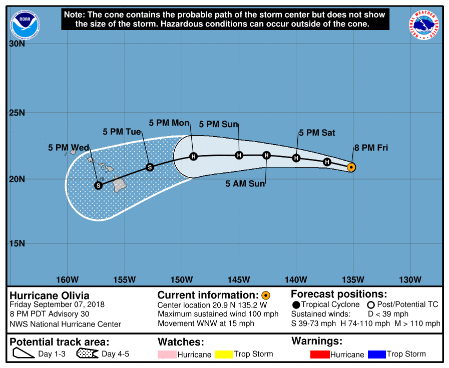
即將在明天進入中太,五天後以TS強度正面影響夏威夷。
224
WTPZ42 KNHC 080256
TCDEP2
Hurricane Olivia Discussion Number 30
NWS National Hurricane Center Miami FL EP172018
800 PM PDT Fri Sep 07 2018
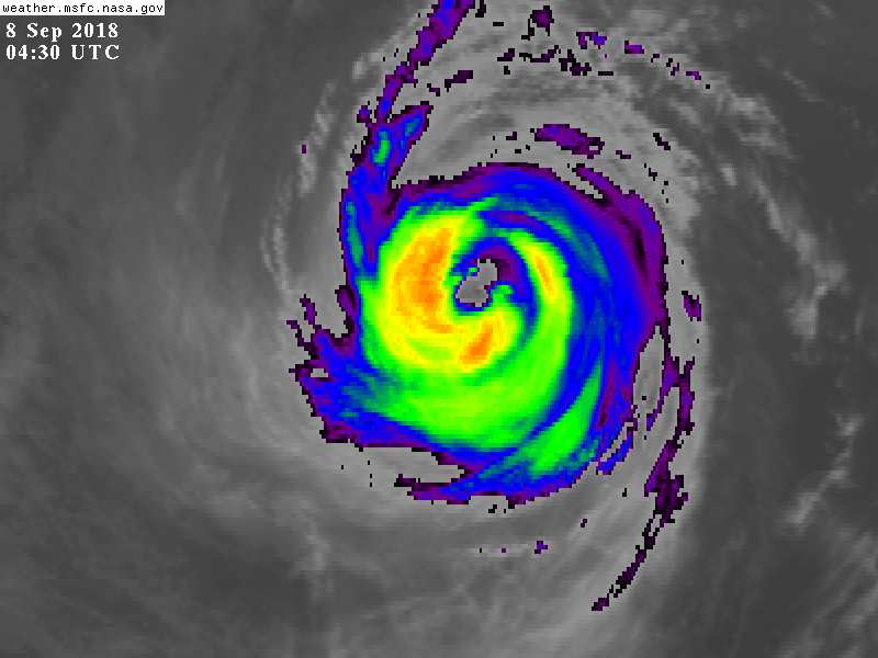
The cloud pattern of Olivia has continued to degrade this evening
with warming of the inner core, and a decreasing eye temperature. A
compromise of the Dvorak satellite intensity estimates, and an
earlier SATCON analysis, support decreasing the initial wind speed
to 85 kt. Olivia still has an annular appearance with the cloud
pattern consisting of an inner core with little to no outer bands.
Continued slow weakening is forecast during the next 3 days as
Olivia moves over marginal sea surface temperatures of about 25C and
into an increasingly drier, more stable thermodynamic environment.
Afterward, Olivia will move back over slightly warmer waters and
remain in a low shear environment, so little change in strength is
expected through day 3. Through the remaining portion of the
forecast, southwesterly vertical wind shear of 15-20 kt should
induce more significant weakening.
Olivia's motion is estimated to be west-northwestward, or 290/13 kt,
and is being steered by a strong deep-layer subtropical ridge that
extends from Mexico and the southwestern U.S. westward into the
central Pacific. The cyclone is forecast to move west-northwestward
for 72 hours or so before turning to the west, or even
west-southwest, as the aforementioned ridge builds to the north. The
official forecast has been adjusted south of the previous forecast
beyond day 3 to conform more with the NOAA-HCCA and TVCN consensus
models. On the forecast track, Olivia is expected to cross into the
central Pacific basin by late Saturday and approach the Hawaiian
Islands in 4 to 5 days.
KEY MESSAGES
1. Olivia is forecast to approach the main Hawaiian Islands from
the east early next week, but it is too soon to determine the exact
location and magnitude of any impacts. Interests in Hawaii should
monitor the progress of Olivia this weekend and use this time to
enact your hurricane action plan.
2. Do not focus on the exact track or intensity forecast, or any
specific landfall location, as errors can be large at extended time
ranges. Tropical storm or hurricane conditions could be felt
anywhere in the islands as significant impacts could extend well
away from the center.
FORECAST POSITIONS AND MAX WINDS
INIT 08/0300Z 20.9N 135.2W 85 KT 100 MPH
12H 08/1200Z 21.3N 137.3W 80 KT 90 MPH
24H 09/0000Z 21.6N 140.0W 75 KT 85 MPH
36H 09/1200Z 21.8N 142.6W 70 KT 80 MPH
48H 10/0000Z 21.8N 145.0W 65 KT 75 MPH
72H 11/0000Z 21.7N 149.0W 65 KT 75 MPH
96H 12/0000Z 20.9N 152.8W 55 KT 65 MPH
120H 13/0000Z 19.5N 157.3W 45 KT 50 MPH
$$
Forecaster Roberts/Birchard


|
|