開啟輔助訪問
 找回密碼
 立即加入

01L.Alex 北大西洋61年來最強1月颶風 由溫帶氣旋轉暖

簽到天數: 588 天

[LV.9]以壇為家II

2016-1-13 00:05 | 顯示全部樓層
  一級颶風  
編號:01L
名稱:Alex
Alex 2016-01-14 1435Z.jpg

  基本資料  
形成日期:2016 01 07 08
命名日期:2016 01 14 05
轉化日期:2016 01 16 05
撤編日期:2016 01 17 03
登陸地點:葡萄牙 亞速自治區特塞拉島

  巔峰時期資料  
近中心最強風速: 75 kt ( Cat.1 )
海平面最低氣壓: 981 百帕

  過去路徑圖  
TWTYBBS_01L_ALEX_TRACK_t02436_TWTYBBS.png

  討論帖圖片  
90L.INVEST.45kts.990mb.24.8N.37.9W

20160112.1545.goes13.x.vis2km.90LINVEST.45kts-990mb-248N-379W.96pc.jpg
20160112.1545.goes13.x.ir1km.90LINVEST.45kts-990mb-248N-379W.100pc.jpg

NHC:40%

1. A non-tropical low pressure system located over the central Atlantic
Ocean about 900 miles southwest of the Azores is producing a large
area of gale-force winds with maximum winds near 60 mph.  Shower
activity is currently limited near the center, but this low could
gradually acquire some subtropical or tropical characteristics
during the next couple of days while it moves southeastward and then
eastward into the eastern subtropical Atlantic.  Regardless of
subtropical or tropical cyclone formation, this system is expected
to produce hazardous marine conditions over portions of the central
and eastern Atlantic for the next few days.  For additional
information, see High Seas Forecasts issued by the National Weather
Service. The next Special Tropical Weather Outlook on this system
will be issued by 2 PM EST Tuesday.
* Formation chance through 48 hours...medium...40 percent
* Formation chance through 5 days...medium...40 percent
two_atl_2d1.png

以上資料來自:NHC、颱風論壇整理製作
回復

使用道具 舉報

簽到天數: 588 天

[LV.9]以壇為家II

Meow|2016-1-13 00:41 | 顯示全部樓層
這種樣子真像風眼,雖然“眼牆”對流很弱。:lol
20160112.1615.goes13.vis1km.90L.INVEST.45kts-990mb-248N-379W.100pc.png
回復

使用道具 舉報

簽到天數: 588 天

[LV.9]以壇為家II

Meow|2016-1-13 22:19 | 顯示全部樓層
再次開「眼」
20160113.1345.goes13.x.vis1km.90LINVEST.45kts-989mb-260N-325W.100pc.jpg
回復

使用道具 舉報

簽到天數: 588 天

[LV.9]以壇為家II

Meow|2016-1-14 02:15 | 顯示全部樓層
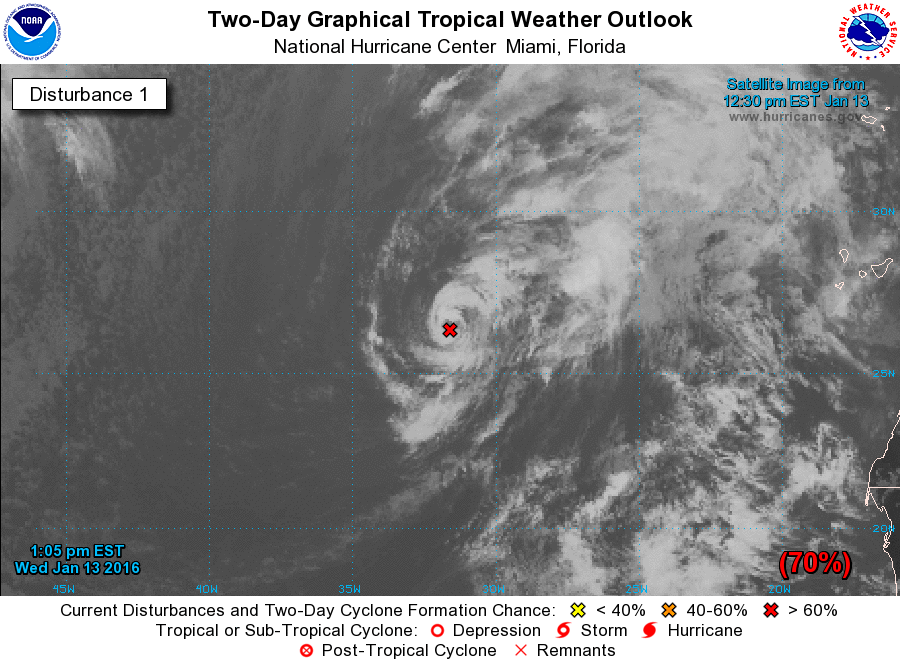
NHC預告半天內有望升格命名。

two_atl_2d1.png

ZCZC MIATWOAT ALL
TTAA00 KNHC DDHHMM

SPECIAL TROPICAL WEATHER OUTLOOK
NWS NATIONAL HURRICANE CENTER MIAMI FL
105 PM EST WED JAN 13 2016

For the North Atlantic...Caribbean Sea and the Gulf of Mexico:

1. Cloudiness and thunderstorms have become a little better organized
since yesterday near the center of a low pressure system centered
about 850 miles south-southwest of the Azores.  If this organizing
trend continues, advisories will be initiated on the system later
today.  The low is producing winds to near 50 mph over the southern
portion of its circulation, and is expected to move northeastward
and northward over the eastern Atlantic over the next few days.
Interests in the Azores should monitor the progress of this system,
and strong gusty winds could begin to affect portions of those
islands by late Thursday or early Friday.  For additional
information, see High Seas Forecasts issued by the National Weather
Service and Meteo France.  The next Special Tropical Weather Outlook
on this system, if needed, will be issued by 2 PM EST Thursday.
* Formation chance through 48 hours...high...70 percent
* Formation chance through 5 days...high...70 percent

High Seas Forecasts issued by the National Weather Service can be
found under AWIPS header NFDHSFAT1, WMO header FZNT01 KWBC, and on
the Web at http://www.opc.ncep.noaa.gov/shtml/NFDHSFAT1.shtml.
High Seas Forecasts issued by Meteo France can be found under WMO
header FQNT50 LFPW.

Forecaster Pasch
回復

使用道具 舉報

簽到天數: 474 天

[LV.9]以壇為家II

劉瑞益@FB|2016-1-14 05:57 | 顯示全部樓層
提示: 作者被禁止或刪除 內容自動屏蔽
回復

使用道具 舉報

簽到天數: 588 天

[LV.9]以壇為家II

Meow|2016-1-14 10:41 | 顯示全部樓層
結構最亮麗的時候其實是在溫帶氣旋階段,而且是在1月10日的「颶風」巔峰時期,擁有相當標緻的「風眼」。

Alex 2016-01-10 1635Z.jpg
https://commons.wikimedia.org/wiki/File:Alex_2016-01-10_1635Z.jpg
回復

使用道具 舉報

簽到天數: 588 天

[LV.9]以壇為家II

Meow|2016-1-14 16:11 | 顯示全部樓層
這結構和對流對於副熱帶風暴而言實在太好了。
20160114.0715.msg3.x.ir1km.01LALEX.55kts-986mb-293N-296W.100pc.jpg

點評

嚴格來說應該是自1955年最強 1955年 Alice 雖於 1554年底生成 但於隔年一月達到最強 80KT  發表於 2016-1-14 23:00
回復

使用道具 舉報

簽到天數: 241 天

[LV.8]以壇為家I

krichard2011|2016-1-14 19:06 | 顯示全部樓層
副熱帶風暴能有這種型態
有點讓人難以置信 = =
20160114.1015.goes13.x.vis1km_high.01LALEX.55kts-986mb-293N-296W.100pc.jpg
20160114.0933.f18.x.colorpct_91h_91v.01LALEX.55kts-986mb-293N-296W.97pc.jpg
回復

使用道具 舉報

12下一頁
快速回覆
您需要登錄後才可以回帖 登錄 | 立即加入

本版積分規則

本平台僅供學術討論之用,預報應以氣象局為準

威普網站虛擬主機贊助公司

臺灣第一個天氣類型社群平台 即時天氣資訊、精準颱風動態

線上客服
FB傳送訊息
廣告行銷
精準行銷 物超所值
官方粉專
發佈 快速回復 返回頂部 返回列表