開啟輔助訪問
 找回密碼
 立即加入

18S.Ilsa 升格澳式C5 登陸西北澳 衝擊澳洲年度風王

簽到天數: 4100 天

[LV.Master]伴壇終老

2023-4-6 03:49 | 顯示全部樓層
本帖最後由 周子堯@FB 於 2023-4-17 16:47 編輯

  五級強烈熱帶氣旋  
編號:23U ( 18 S )
名稱:Ilsa

  基本資料  
擾動編號日期 :2023 04 06 02
JTWC升格日期: 2023 04 08 08
命名日期   :2023 04 11 14
撤編日期   :2023 04 16 02
登陸地點   :

  巔峰時期資料  
近中心最強風速
澳洲氣象局 (BoM):117 kt
聯合颱風警報中心(JTWC):140 kt (  Cat.5 )
海平面最低氣壓:928 百帕

  擾動/基本資料    
98S.INVEST.15kts.1010mb.7.0S.134.9E


20230405.081000.SH982023.ahi.himawari-9.WV.15kts.100p0.1p0.jpg

評分

參與人數 1水氣能量 +15 +1 收起 理由
周子堯@FB + 15 + 1 熱帶擾動首帖

查看全部評分

回復

使用道具 舉報

簽到天數: 241 天

[LV.8]以壇為家I

krichard2011|2023-4-8 22:39 | 顯示全部樓層
JTWC 發布TCFA

數值模式看好發展~
sh9823.gif
回復

使用道具 舉報

簽到天數: 241 天

[LV.8]以壇為家I

krichard2011|2023-4-9 08:42 | 顯示全部樓層
JTWC 對這個系統的前景非常看好
第一報直接上看 C5 140KT
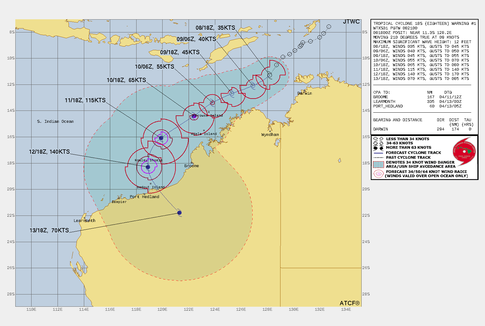
sh1823.gif

  1. WTXS31 PGTW 082100
  2. MSGID/GENADMIN/JOINT TYPHOON WRNCEN PEARL HARBOR HI//
  3. SUBJ/TROPICAL CYCLONE 18S (EIGHTEEN) WARNING NR 001//
  4. REF/A/MSG/JOINT TYPHOON WRNCEN PEARL HARBOR HI/071952ZAPR2023//
  5. AMPN/REF A IS A TROPICAL CYCLONE FORMATION ALERT./
  6. RMKS/
  7. 1. TROPICAL CYCLONE 18S (EIGHTEEN) WARNING NR 001   
  8.    01 ACTIVE TROPICAL CYCLONE IN SOUTHIO
  9.    MAX SUSTAINED WINDS BASED ON ONE-MINUTE AVERAGE
  10.    WIND RADII VALID OVER OPEN WATER ONLY
  11.     ---
  12.    WARNING POSITION:
  13.    081800Z --- NEAR 11.3S 128.2E
  14.      MOVEMENT PAST SIX HOURS - 210 DEGREES AT 09 KTS
  15.      POSITION ACCURATE TO WITHIN 030 NM
  16.      POSITION BASED ON CENTER LOCATED BY A COMBINATION OF
  17.      SATELLITE, SYNOPTIC DATA AND EXTRAPOLATION
  18.    PRESENT WIND DISTRIBUTION:
  19.    MAX SUSTAINED WINDS - 035 KT, GUSTS 045 KT
  20.    WIND RADII VALID OVER OPEN WATER ONLY
  21.    RADIUS OF 034 KT WINDS - 070 NM NORTHEAST QUADRANT
  22.                             045 NM SOUTHEAST QUADRANT
  23.                             065 NM SOUTHWEST QUADRANT
  24.                             040 NM NORTHWEST QUADRANT
  25.    REPEAT POSIT: 11.3S 128.2E
  26.     ---
  27.    FORECASTS:
  28.    12 HRS, VALID AT:
  29.    090600Z --- 12.1S 126.9E
  30.    MAX SUSTAINED WINDS - 040 KT, GUSTS 050 KT
  31.    WIND RADII VALID OVER OPEN WATER ONLY
  32.    RADIUS OF 034 KT WINDS - 050 NM NORTHEAST QUADRANT
  33.                             060 NM SOUTHEAST QUADRANT
  34.                             060 NM SOUTHWEST QUADRANT
  35.                             030 NM NORTHWEST QUADRANT
  36.    VECTOR TO 24 HR POSIT: 250 DEG/ 08 KTS
  37.     ---
  38.    24 HRS, VALID AT:
  39.    091800Z --- 12.7S 125.3E
  40.    MAX SUSTAINED WINDS - 045 KT, GUSTS 055 KT
  41.    WIND RADII VALID OVER OPEN WATER ONLY
  42.    RADIUS OF 034 KT WINDS - 030 NM NORTHEAST QUADRANT
  43.                             060 NM SOUTHEAST QUADRANT
  44.                             050 NM SOUTHWEST QUADRANT
  45.                             020 NM NORTHWEST QUADRANT
  46.    VECTOR TO 36 HR POSIT: 245 DEG/ 08 KTS
  47.     ---
  48.    36 HRS, VALID AT:
  49.    100600Z --- 13.4S 123.8E
  50.    MAX SUSTAINED WINDS - 055 KT, GUSTS 070 KT
  51.    WIND RADII VALID OVER OPEN WATER ONLY
  52.    RADIUS OF 050 KT WINDS - 010 NM NORTHEAST QUADRANT
  53.                             010 NM SOUTHEAST QUADRANT
  54.                             010 NM SOUTHWEST QUADRANT
  55.                             000 NM NORTHWEST QUADRANT
  56.    RADIUS OF 034 KT WINDS - 040 NM NORTHEAST QUADRANT
  57.                             070 NM SOUTHEAST QUADRANT
  58.                             060 NM SOUTHWEST QUADRANT
  59.                             040 NM NORTHWEST QUADRANT
  60.    VECTOR TO 48 HR POSIT: 235 DEG/ 08 KTS
  61.     ---
  62.    EXTENDED OUTLOOK:
  63.    48 HRS, VALID AT:
  64.    101800Z --- 14.4S 122.4E
  65.    MAX SUSTAINED WINDS - 065 KT, GUSTS 080 KT
  66.    WIND RADII VALID OVER OPEN WATER ONLY
  67.    RADIUS OF 064 KT WINDS - 000 NM NORTHEAST QUADRANT
  68.                             010 NM SOUTHEAST QUADRANT
  69.                             000 NM SOUTHWEST QUADRANT
  70.                             000 NM NORTHWEST QUADRANT
  71.    RADIUS OF 050 KT WINDS - 010 NM NORTHEAST QUADRANT
  72.                             020 NM SOUTHEAST QUADRANT
  73.                             020 NM SOUTHWEST QUADRANT
  74.                             010 NM NORTHWEST QUADRANT
  75.    RADIUS OF 034 KT WINDS - 060 NM NORTHEAST QUADRANT
  76.                             090 NM SOUTHEAST QUADRANT
  77.                             080 NM SOUTHWEST QUADRANT
  78.                             050 NM NORTHWEST QUADRANT
  79.    VECTOR TO 72 HR POSIT: 235 DEG/ 07 KTS
  80.     ---
  81.    72 HRS, VALID AT:
  82.    111800Z --- 16.1S 119.9E
  83.    MAX SUSTAINED WINDS - 115 KT, GUSTS 140 KT
  84.    WIND RADII VALID OVER OPEN WATER ONLY
  85.    RADIUS OF 064 KT WINDS - 030 NM NORTHEAST QUADRANT
  86.                             030 NM SOUTHEAST QUADRANT
  87.                             030 NM SOUTHWEST QUADRANT
  88.                             020 NM NORTHWEST QUADRANT
  89.    RADIUS OF 050 KT WINDS - 040 NM NORTHEAST QUADRANT
  90.                             050 NM SOUTHEAST QUADRANT
  91.                             040 NM SOUTHWEST QUADRANT
  92.                             040 NM NORTHWEST QUADRANT
  93.    RADIUS OF 034 KT WINDS - 090 NM NORTHEAST QUADRANT
  94.                             120 NM SOUTHEAST QUADRANT
  95.                             090 NM SOUTHWEST QUADRANT
  96.                             080 NM NORTHWEST QUADRANT
  97.    VECTOR TO 96 HR POSIT: 205 DEG/ 06 KTS
  98.     ---
  99.    LONG RANGE OUTLOOK:
  100.     ---
  101.    96 HRS, VALID AT:
  102.    121800Z --- 18.3S 118.9E
  103.    MAX SUSTAINED WINDS - 140 KT, GUSTS 170 KT
  104.    WIND RADII VALID OVER OPEN WATER ONLY
  105.    RADIUS OF 064 KT WINDS - 040 NM NORTHEAST QUADRANT
  106.                             030 NM SOUTHEAST QUADRANT
  107.                             030 NM SOUTHWEST QUADRANT
  108.                             030 NM NORTHWEST QUADRANT
  109.    RADIUS OF 050 KT WINDS - 060 NM NORTHEAST QUADRANT
  110.                             060 NM SOUTHEAST QUADRANT
  111.                             050 NM SOUTHWEST QUADRANT
  112.                             050 NM NORTHWEST QUADRANT
  113.    RADIUS OF 034 KT WINDS - 120 NM NORTHEAST QUADRANT
  114.                             120 NM SOUTHEAST QUADRANT
  115.                             100 NM SOUTHWEST QUADRANT
  116.                             090 NM NORTHWEST QUADRANT
  117.    VECTOR TO 120 HR POSIT: 150 DEG/ 10 KTS
  118.     ---
  119.    120 HRS, VALID AT:
  120.    131800Z --- 21.8S 121.3E
  121.    MAX SUSTAINED WINDS - 070 KT, GUSTS 085 KT
  122.     ---
  123. REMARKS:
  124. 082100Z POSITION NEAR 11.5S 127.9E.
  125. 08APR23. TROPICAL CYCLONE 18S (EIGHTEEN), LOCATED APPROXIMATELY
  126. 174 NM WEST-NORTHWEST OF DARWIN, AUSTRALIA, HAS TRACKED SOUTH-
  127. SOUTHWESTWARD AT 09 KNOTS OVER THE PAST SIX HOURS. MAXIMUM
  128. SIGNIFICANT WAVE HEIGHT AT 081800Z IS 12 FEET. NEXT WARNINGS AT
  129. 090300Z, 090900Z, 091500Z AND 092100Z.
  130. 2. THIS CANCELS AND SUPERSEDES REF A (WTXS21 PGTW 072000).//
  131. NNNN
複製代碼
回復

使用道具 舉報

簽到天數: 241 天

[LV.8]以壇為家I

krichard2011|2023-4-11 16:21 | 顯示全部樓層
BoM 稍早升格一級熱帶氣旋
強度上看四級熱帶氣旋 威脅澳洲西岸
逐漸進入低風切區域
底層型態不錯 預計強度將逐漸增強
wgmsshr.gif
20230411.053905.SH182023.amsr2.gcom-w1.color89.55kts.94p7.1p0.jpg
IDW60280.png
  1. IDW27600
  2. TROPICAL CYCLONE TECHNICAL BULLETIN: AUSTRALIA - WESTERN REGION
  3. Issued by AUSTRALIAN BUREAU OF METEOROLOGY TROPICAL CYCLONE WARNING CENTRE
  4. at: 0720 UTC 11/04/2023
  5. Name: Tropical Cyclone Ilsa
  6. Identifier: 23U
  7. Data At: 0600 UTC
  8. Latitude: 14.5S
  9. Longitude: 121.2E
  10. Location Accuracy: within 20nm (35 km)
  11. Movement Towards: southwest (235 deg)
  12. Speed of Movement: 7 knots (13 km/h)
  13. Maximum 10-Minute Wind: 40 knots (75 km/h)
  14. Maximum 3-Second Wind Gust: 55 knots (100 km/h)
  15. Central Pressure: 994 hPa
  16. Radius of 34-knot winds NE quadrant:
  17. Radius of 34-knot winds SE quadrant: 80 nm (150 km)
  18. Radius of 34-knot winds SW quadrant: 80 nm (150 km)
  19. Radius of 34-knot winds NW quadrant: 60 nm (110 km)
  20. Radius of 48-knot winds NE quadrant:
  21. Radius of 48-knot winds SE quadrant:
  22. Radius of 48-knot winds SW quadrant:
  23. Radius of 48-knot winds NW quadrant:
  24. Radius of 64-knot winds:  nm ( km)
  25. Radius of Maximum Winds: 20 nm (35 km)
  26. Dvorak Intensity Code: T3.0/3.0/S0.0/24HRS STT:D0.5/6HRS
  27. Pressure of outermost isobar: 1004 hPa
  28. Radius of outermost closed isobar: 130 nm (240 km)
  29. FORECAST DATA
  30. Date/Time    : Location    : Loc. Accuracy: Max Wind   : Central Pressure
  31. (UTC)        : degrees     :      nm  (km): knots(km/h): hPa
  32. +06:  11/1200: 14.9S 120.9E:     040 (070):  045  (085):  990
  33. +12:  11/1800: 15.3S 120.4E:     050 (095):  055  (100):  984
  34. +18:  12/0000: 15.7S 120.0E:     060 (115):  060  (110):  980
  35. +24:  12/0600: 16.1S 119.7E:     070 (125):  070  (130):  972
  36. +36:  12/1800: 16.8S 119.2E:     085 (155):  085  (155):  959
  37. +48:  13/0600: 18.0S 119.2E:     105 (190):  095  (175):  950
  38. +60:  13/1800: 19.5S 120.4E:     120 (225):  090  (165):  953
  39. +72:  14/0600: 21.1S 123.4E:     145 (265):  040  (075):  994
  40. +96:  15/0600: 23.0S 134.0E:     200 (370):  030  (055): 1003
  41. +120: 16/0600:             :              :            :     
  42. REMARKS:
  43. Tropical Cyclone Ilsa has developed northwest of the Kimberley.

  44. Good confidence in the position of 23U with visible imagery and recent
  45. microwave passes.

  46. Intensity is 40 knots based on recent SMAP data and development of curved band,
  47. which gives greater confidence in Dvorak analysis of DT = 3.0. MET = 3.5 based
  48. on D- 24 hour trend. PAT is 3.0. FT = 3.0 based on DT. CI maintained at 3.0.
  49. Objective guidance is becoming more credible with development of curved
  50. banding. Available objective guidance with SATCON 53 knots (1-min), CIMSS ADT
  51. 57 knots (1-min), NESDIS ADT 57 knots (1-min) and OPEN-AIIR about 35 knots.  

  52. Wind shear has decreased over 23U and at 0600 UTC, CIMSS upper wind analysis
  53. has analysed approximately 15 knots of shear. The system should begin a rapid
  54. development cycle with favourable shear, high mid-level moisture and warm SSTs
  55. (30+ degrees Celsius).

  56. Upper divergence to the south increases and the system is forecast to develop
  57. into a severe tropical cyclone from Wednesday, likely reaching a category 4
  58. system during Thursday. 23U is forecast to move southwest parallel to and
  59. offshore from the Kimberley coast during Tuesday and Wednesday before turning
  60. south and then southeast during Thursday, with a coastal crossing likely later
  61. Thursday or early Friday between Port Hedland and Broome.

  62. The forecast track is based on a standard consensus of numerical weather
  63. prediction (NWP) models. This track is consistent with upper-air analyses which
  64. show a mid-upper ridge over the NT and an approaching upper trough over
  65. southern WA. There is relatively high confidence in this forecast track. In the
  66. long-term, 23U is forecast to move over central Australia and begin a
  67. transition to a deep, sub-tropical system as it interacts with the sub-tropical
  68. jet.  

  69. Intensity forecasts are based on a rapid rate of development prior to landfall,
  70. with a landfall intensity of 95 knots (Category 4). This is consistent with a
  71. consensus of NWP models. 23U is forecast to remain a strong system as it moves
  72. inland on Friday.  

  73. Copyright Commonwealth of Australia
  74. ==
  75. The next bulletin for this system will be issued by: 11/1330 UTC
複製代碼


回復

使用道具 舉報

簽到天數: 241 天

[LV.8]以壇為家I

krichard2011|2023-4-11 23:55 | 顯示全部樓層
12Z 升格澳式C2 上看澳式C4

深對流大量爆發中
572e3b32-7023-47a9-93bd-9b8d3f6afbf4.jpg
IDW60280.png
  1. IDW27600
  2. TROPICAL CYCLONE TECHNICAL BULLETIN: AUSTRALIA - WESTERN REGION
  3. Issued by AUSTRALIAN BUREAU OF METEOROLOGY TROPICAL CYCLONE WARNING CENTRE
  4. at: 1348 UTC 11/04/2023
  5. Name: Tropical Cyclone Ilsa
  6. Identifier: 23U
  7. Data At: 1200 UTC
  8. Latitude: 15.2S
  9. Longitude: 120.5E
  10. Location Accuracy: within 20nm (35 km)
  11. Movement Towards: southwest (233 deg)
  12. Speed of Movement: 9 knots (17 km/h)
  13. Maximum 10-Minute Wind: 55 knots (100 km/h)
  14. Maximum 3-Second Wind Gust: 75 knots (140 km/h)
  15. Central Pressure: 985 hPa
  16. Radius of 34-knot winds NE quadrant: 60 nm (110 km)
  17. Radius of 34-knot winds SE quadrant: 80 nm (150 km)
  18. Radius of 34-knot winds SW quadrant: 80 nm (150 km)
  19. Radius of 34-knot winds NW quadrant: 60 nm (110 km)
  20. Radius of 48-knot winds NE quadrant: 30 nm (55 km)
  21. Radius of 48-knot winds SE quadrant: 30 nm (55 km)
  22. Radius of 48-knot winds SW quadrant: 30 nm (55 km)
  23. Radius of 48-knot winds NW quadrant: 30 nm (55 km)
  24. Radius of 64-knot winds:  nm ( km)
  25. Radius of Maximum Winds: 20 nm (35 km)
  26. Dvorak Intensity Code: T4.0/4.0/D1.5/24HRS  STT:D0.5/06HRS
  27. Pressure of outermost isobar: 1004 hPa
  28. Radius of outermost closed isobar: 150 nm (280 km)
  29. FORECAST DATA
  30. Date/Time    : Location    : Loc. Accuracy: Max Wind   : Central Pressure
  31. (UTC)        : degrees     :      nm  (km): knots(km/h): hPa
  32. +06:  11/1800: 15.5S 120.2E:     040 (070):  060  (110):  980
  33. +12:  12/0000: 15.8S 119.9E:     050 (090):  065  (120):  976
  34. +18:  12/0600: 16.2S 119.6E:     055 (105):  070  (130):  972
  35. +24:  12/1200: 16.5S 119.3E:     065 (120):  080  (150):  964
  36. +36:  13/0000: 17.5S 118.9E:     080 (150):  090  (165):  952
  37. +48:  13/1200: 18.9S 119.5E:     100 (180):  095  (175):  948
  38. +60:  14/0000: 20.4S 121.6E:     115 (215):  070  (130):  964
  39. +72:  14/1200: 21.8S 125.7E:     140 (255):  040  (075):  997
  40. +96:  15/1200: 22.7S 136.8E:     210 (385):  030  (055): 1002
  41. +120: 16/1200:             :              :            :     
  42. REMARKS:
  43. Tropical Cyclone Ilsa has developed rapidly during the past 6 hours, with
  44. bursting convection and symmetric structure evident. Good position fix based on
  45. overshooting cold tops in EIR imagery and recent microwave passes.

  46. Dvorak analysis yields FT = 4.0 based on MET/PAT and D+ 24h trend. DT not
  47. available due to development of central cold cover pattern. Available objective
  48. guidance with SATCON 55 knots (1-min), CIMSS ADT 59 knots (1-min), NESDIS ADT
  49. 57 knots (1-min) and OPEN-AIIR about 42 knots. Intensity is set at 55 knots.

  50. CIMSS upper wind shear analysed at 10-15 knots over the cyclone at 1200 UTC.
  51. Ilsa is forecast to develop at a greater than standard rate with favourable
  52. shear, high mid-level moisture and warm SSTs (30+ degrees Celsius) along the
  53. forecast track. Upper divergence is expected to increase to the south ahead of
  54. an approaching mid-latitude trough.

  55. The cyclone is forecast to intensify into a severe tropical cyclone from
  56. Wednesday, likely reaching a category 4 intensity during Thursday. Ilsa is
  57. forecast to move southwest parallel to and offshore from the Kimberley coast
  58. during Wednesday before turning south and then southeast during Thursday, with
  59. a coastal crossing likely later Thursday or early Friday between De Grey and
  60. Bidyadanga.

  61. The forecast track is based on a standard consensus of numerical weather
  62. prediction (NWP) models, consistent with a mid-upper ridge over the NT and an
  63. approaching upper trough over southern WA. There is relatively high confidence
  64. in this forecast track. In the long-term, the cyclone is forecast to move over
  65. central Australia and begin a transition to a deep, sub-tropical system as it
  66. interacts with the sub-tropical jet.  

  67. Intensity forecasts are based on a rapid rate of development prior to landfall,
  68. with a landfall intensity of 95 knots (Category 4). This is consistent with a
  69. consensus of NWP models. Tropical Cyclone Ilsa is forecast to remain a strong
  70. system as it moves inland on Friday.  

  71. Copyright Commonwealth of Australia
  72. ==
  73. The next bulletin for this system will be issued by: 11/1930 UTC.
複製代碼


回復

使用道具 舉報

簽到天數: 241 天

[LV.8]以壇為家I

krichard2011|2023-4-12 12:24 | 顯示全部樓層
底層結構大致已建構完成

距模式預測登陸還剩下1~2天左右發展空間
20230411.214400.SH182023.ssmis.F17.color89.80kts.67p5.1p0.jpg
IDW60280.png
  1. IDW27600
  2. TROPICAL CYCLONE TECHNICAL BULLETIN: AUSTRALIA - WESTERN REGION
  3. Issued by AUSTRALIAN BUREAU OF METEOROLOGY TROPICAL CYCLONE WARNING CENTRE
  4. at: 0127 UTC 12/04/2023
  5. Name: Tropical Cyclone Ilsa
  6. Identifier: 23U
  7. Data At: 0000 UTC
  8. Latitude: 15.7S
  9. Longitude: 119.8E
  10. Location Accuracy: within 25nm (45 km)
  11. Movement Towards: southwest (235 deg)
  12. Speed of Movement: 4 knots (7 km/h)
  13. Maximum 10-Minute Wind: 60 knots (110 km/h)
  14. Maximum 3-Second Wind Gust: 85 knots (155 km/h)
  15. Central Pressure: 981 hPa
  16. Radius of 34-knot winds NE quadrant: 60 nm (110 km)
  17. Radius of 34-knot winds SE quadrant: 80 nm (150 km)
  18. Radius of 34-knot winds SW quadrant: 80 nm (150 km)
  19. Radius of 34-knot winds NW quadrant: 80 nm (150 km)
  20. Radius of 48-knot winds NE quadrant: 35 nm (65 km)
  21. Radius of 48-knot winds SE quadrant: 35 nm (65 km)
  22. Radius of 48-knot winds SW quadrant: 35 nm (65 km)
  23. Radius of 48-knot winds NW quadrant: 35 nm (65 km)
  24. Radius of 64-knot winds:  nm ( km)
  25. Radius of Maximum Winds: 15 nm (30 km)
  26. Dvorak Intensity Code: T4.0/4.0/D1.5/24HRS STT:S0.5/6HRS
  27. Pressure of outermost isobar: 1006 hPa
  28. Radius of outermost closed isobar: 180 nm (335 km)
  29. FORECAST DATA
  30. Date/Time    : Location    : Loc. Accuracy: Max Wind   : Central Pressure
  31. (UTC)        : degrees     :      nm  (km): knots(km/h): hPa
  32. +06:  12/0600: 16.1S 119.7E:     040 (075):  070  (130):  974
  33. +12:  12/1200: 16.5S 119.4E:     050 (095):  080  (150):  965
  34. +18:  12/1800: 16.9S 119.2E:     055 (105):  085  (155):  961
  35. +24:  13/0000: 17.4S 119.0E:     065 (120):  095  (175):  952
  36. +36:  13/1200: 18.8S 119.4E:     075 (135):  100  (185):  945
  37. +48:  14/0000: 20.2S 121.4E:     100 (185):  075  (140):  969
  38. +60:  14/1200: 21.5S 125.3E:     125 (230):  045  (085):  993
  39. +72:  15/0000: 22.4S 130.8E:     150 (280):  035  (065): 1001
  40. +96:  16/0000:             :              :            :     
  41. +120: 17/0000:             :              :            :     
  42. REMARKS:
  43. Tropical Cyclone Ilsa continues to develop, and a rapid intensification likely
  44. over the next 24 hours.

  45. Moderate to good confidence in the position of 23U with recent microwave pass
  46. and the slow movement of the system.  

  47. Dvorak analysis of DT = 4.5, MET/PT = 4.0, and D 24 hour trend. FT/CI at 4.0.
  48. Objective guidance, with ADT CI of 4.4 CIMSS and 4.0 NESDIS, SATCON at 69
  49. knots, AiDT  71 knots, and Open-AIIR at 55 to 60 knots (1-min). SMOS 2218UTC
  50. has 50-64 knots near the centre. Intensity is set at 60 knots based on Dvorak
  51. CI of 4.0.

  52. Wind shear remains low over 23U and at 0000 UTC CIMSS upper wind analysis has
  53. analysed approximately 10 knots of shear. The system should begin a rapid
  54. development cycle with favourable shear, high mid-level moisture and warm SSTs
  55. (30+ degrees Celsius). CIMSS AI-RI guidance suggests at high probability of a
  56. 30 to 35 knot increase in intensity over the next 24 hours. Intensity forecasts
  57. are based on a rapid rate of development prior to landfall, with a landfall
  58. intensity of 105 knots (Category 4). This is consistent with a consensus of NWP
  59. models. 23U is forecast to remain a strong system as it moves inland on Friday.


  60. The forecast track is based on a standard consensus of numerical weather
  61. prediction (NWP) models. This track is consistent with upper-air analyses which
  62. show a mid-upper ridge over the NT and an approaching upper trough over
  63. southern WA. There is relatively high confidence in this forecast track. Ilsa
  64. is forecast to move southwest parallel to and offshore from the Kimberley coast
  65. during Wednesday before turning south and then southeast during Thursday, with
  66. a coastal crossing likely later Thursday or early Friday between Port Hedland
  67. and Broome, most likely in vicinity of Wallal Downs. In the long-term, Ilsa is
  68. forecast to move over central Australia and begin a transition to a deep,
  69. sub-tropical system as it interacts with the sub-tropical jet.  

  70. Copyright Commonwealth of Australia
  71. ==
  72. The next bulletin for this system will be issued by: 12/0730 UTC.
複製代碼


JTWC
  1. 18S ILSA 230412 0000 15.7S 119.9E SHEM 80 974
複製代碼
回復

使用道具 舉報

簽到天數: 1989 天

[LV.Master]伴壇終老

ben811018|2023-4-13 14:40 | 顯示全部樓層


【4級熱帶氣旋ILSA】
目前位於位於澳洲西北方海域
過去幾個小時快速增強
核心變得更紮實,風眼清晰可見
即將達到巔峰狀態~
目前強度相當於強烈颱風
環流廣達700公里
很巨很大隻
預計今天夜晚就會登陸!

b13ca (2).gif 7892.PNG 123456.png rb-animated (1).gif
回復

使用道具 舉報

簽到天數: 241 天

[LV.8]以壇為家I

krichard2011|2023-4-13 18:31 | 顯示全部樓層
路徑有機會掃過 Bedout Island
目前實測平均風 65KT 陣風 85KT 最低氣壓 982.1 hPa
download.png

http://www.bom.gov.au/products/IDW60801/IDW60801.94310.shtml

  1. IDW27600
  2. TROPICAL CYCLONE TECHNICAL BULLETIN: AUSTRALIA - WESTERN REGION
  3. Issued by AUSTRALIAN BUREAU OF METEOROLOGY TROPICAL CYCLONE WARNING CENTRE
  4. at: 0719 UTC 13/04/2023
  5. Name: Severe Tropical Cyclone Ilsa
  6. Identifier: 23U
  7. Data At: 0600 UTC
  8. Latitude: 18.7S
  9. Longitude: 118.8E
  10. Location Accuracy: within 10nm (20 km)
  11. Movement Towards: south (188 deg)
  12. Speed of Movement: 10 knots (19 km/h)
  13. Maximum 10-Minute Wind: 110 knots (205 km/h)
  14. Maximum 3-Second Wind Gust: 155 knots (285 km/h)
  15. Central Pressure: 930 hPa
  16. Radius of 34-knot winds NE quadrant: 80 nm (150 km)
  17. Radius of 34-knot winds SE quadrant: 70 nm (130 km)
  18. Radius of 34-knot winds SW quadrant: 50 nm (95 km)
  19. Radius of 34-knot winds NW quadrant: 80 nm (150 km)
  20. Radius of 48-knot winds NE quadrant: 45 nm (85 km)
  21. Radius of 48-knot winds SE quadrant: 40 nm (75 km)
  22. Radius of 48-knot winds SW quadrant: 30 nm (55 km)
  23. Radius of 48-knot winds NW quadrant: 40 nm (75 km)
  24. Radius of 64-knot winds: 25 nm (25 km)
  25. Radius of Maximum Winds: 10 nm (20 km)
  26. Dvorak Intensity Code: T6.5/6.5/D2.0/24HRS STT:D1.0/06HRS
  27. Pressure of outermost isobar: 1004 hPa
  28. Radius of outermost closed isobar: 150 nm (280 km)
  29. FORECAST DATA
  30. Date/Time    : Location    : Loc. Accuracy: Max Wind   : Central Pressure
  31. (UTC)        : degrees     :      nm  (km): knots(km/h): hPa
  32. +06:  13/1200: 19.6S 118.9E:     025 (050):  120  (220):  923
  33. +12:  13/1800: 20.4S 119.7E:     040 (070):  095  (175):  948
  34. +18:  14/0000: 21.2S 121.0E:     045 (085):  070  (130):  971
  35. +24:  14/0600: 22.0S 122.7E:     055 (100):  055  (100):  983
  36. +36:  14/1800: 22.8S 127.5E:     065 (120):  035  (065):  998
  37. +48:  15/0600: 23.0S 133.9E:     085 (155):  030  (055): 1003
  38. +60:  15/1800:             :              :            :     
  39. +72:  16/0600:             :              :            :     
  40. +96:  17/0600:             :              :            :     
  41. +120: 18/0600:             :              :            :     
  42. REMARKS:
  43. Severe Tropical Cyclone Ilsa has reached category 5.

  44. There is good confidence in the position of the system with an eye visible and
  45. within range of Port Hedland weather radar.

  46. Dvorak analysis of 3 hourly average DT of 6.5 based on an eye pattern. 06Z eye
  47. pattern was CMG surrounding temperature with a DG/CMG eye adjustment, giving a
  48. DT of 7.0. MET yielded 6.5 base on a D++ 24 hour trend with PAT 6.5. FT/CI=6.5
  49. based on 3 hourly average DT.

  50. Objective guidance, with ADT CI of 5.0 CIMSS and 5.0 NESDIS, AiDT   92 knots,
  51. and Open-AIIR ranging between 90 to 110 knots (1-min). ADT appears limited by
  52. constraints and not seeing the eye pattern. Intensity set to 110 knots
  53. (category 5) based mainly on Dvorak and a very clear eye pattern.

  54. Wind shear remains moderately low over 23U and at 0600 UTC CIMSS upper wind
  55. analysis has approximately 10 to 15 knots of shear. The system has been
  56. undergoing rapid development within the last 24 hors with favourable shear,
  57. high mid-level moisture and warm SSTs (30+ degrees Celsius). The current
  58. forecast intensity is based on continued development until making landfall.
  59. This is consistent with a consensus of NWP models. 23U is forecast to weaken
  60. quickly once over land, but remain at least category 2 a significant distance
  61. inland.  

  62. Ilsa has been moving south and is forecast to take a turn to the southeast in
  63. the next 6 hours. With recent motion to the south, persistence means the
  64. forecast track crosses the coast further west than model guidance. A coastal
  65. crossing is likely later tonight or early Friday morning east of Port Hedland
  66. and west of Wallal Downs. In the long-term, Ilsa is forecast to move over
  67. central Australia and begin a transition to a deep, sub-tropical system as it
  68. interacts with the sub-tropical jet.  

  69. Copyright Commonwealth of Australia
  70. ==
  71. The next bulletin for this system will be issued by: 13/1330 UTC.
複製代碼
回復

使用道具 舉報

12下一頁
快速回覆
您需要登錄後才可以回帖 登錄 | 立即加入

本版積分規則

本平台僅供學術討論之用,預報應以氣象局為準

威普網站虛擬主機贊助公司

臺灣第一個天氣類型社群平台 即時天氣資訊、精準颱風動態

線上客服
FB傳送訊息
廣告行銷
精準行銷 物超所值
官方粉專
發佈 快速回復 返回頂部 返回列表