開啟輔助訪問
 找回密碼
 立即加入

09L.Ian 中心出海 轉向北上

簽到天數: 601 天

[LV.9]以壇為家II

2022-9-21 10:35 | 顯示全部樓層
基本資料  
編號    :98 L
擾動編號日期:2022 09 20 20
撤編日期  :2022 00 00 00
98L.INVEST.25kts-1011mb-10.3N-53.0W
20220920.1230.goes-16.ir.98L.INVEST.25kts.1011mb.10.3N.53W.100pc.jpg
A tropical wave located several hundred miles east of the Windward
Islands is producing a broad area of disorganized showers and
thunderstorms while moving westward at 15-20 mph.  Gradual
development of this system is forecast during the next several days
as the system approaches the Windward Islands, and a tropical
depression could form by the latter part of this week as the system
moves into the eastern and central Caribbean sea.
* Formation chance through 48 hours...low...10 percent.
* Formation chance through 5 days...medium...50 percent.

two_atl_2d2.png
回復

使用道具 舉報

簽到天數: 601 天

[LV.9]以壇為家II

霧峰追風者|2022-9-21 10:37 | 顯示全部樓層
two_atl_2d1.png 1. Central Tropical Atlantic:
A tropical wave is producing shower and thunderstorm activity a few
hundred miles east of the Windward Islands. The system continues to
show signs of organization and it will likely become a tropical
depression within the next two or three days. The disturbance is
forecast to move west-northwestward across the southern Windward
Islands late Wednesday and then move toward the central Caribbean
Sea late this week. Interests in the Windward Islands should closely
monitor the progress of this system as heavy rainfall and gusty
winds could affect these islands beginning on Wednesday.  
* Formation chance through 48 hours...high...70 percent.
* Formation chance through 5 days...high...90 percent.


回復

使用道具 舉報

簽到天數: 601 天

[LV.9]以壇為家II

霧峰追風者|2022-9-23 18:13 | 顯示全部樓層
WTNT44 KNHC 230907 CCA
TCDAT4

Tropical Depression Nine Discussion Number   1...Corrected
NWS National Hurricane Center Miami FL       AL092022
500 AM AST Fri Sep 23 2022

Corrected location of convection in first paragraph.

Convection this morning has increased primarily to the west of the
area of low pressure we have been monitoring in the central
Caribbean Sea, currently passing by to the north of Curacao island.
The system already possessed a well-defined circulation for the last
12 to 18 hours, but it was only overnight that the ongoing
convective activity was able to persist long enough near the center
to be considered a tropical cyclone. The most recent satellite
intensity estimate from TAFB was up to T2.5/35-kt. However the
GOES-16 derived motion winds from the meso sector over the system
have only been 25-30 kt in the 925-850 mb layer on the northeastern
periphery of the circulation. In addition, buoy 42059 located to the
northeast of the center has been reporting winds up to only 27-kt.
The combination of all these data provide enough justification to
upgrade this system to Tropical Depression Nine, with the initial
winds set at 30 kt for this advisory. An Air Force Reserve
Reconnaissance mission will be investigating the system later this
morning to provide more in-situ information of the system's
structure and intensity.

The current motion right now is estimated to be off to the
west-northwest at 290/12 kt. In the short-term, the depression is
forecast to bend back more westward as a narrow east-to-west
oriented mid-level ridge builds in behind the weakness left behind
from Fiona. The current eastward displaced convection may also tug
the broad center in that direction as well. However, after 48 hours,
this ridge will start to decay as a longwave deep-layer trough over
the eastern United States begins to amplify southward. This synoptic
evolution should then allow the cyclone to begin gaining latitude,
though the exact timing at which this occurs could be somewhat
related to the vertical depth of the cyclone and how it interacts
with a weak upper-level trough expected to be over the far western
Caribbean in the day 3-4 time-frame. The model guidance early on is
in fairly good agreement, but larger across-track spread begins to
take shape by 48 hours, with the GFS and its ensemble mean located
further south and west, and with the ECMWF and its ensemble mean
located further north and east. The initial track forecast has
decided to split the difference between these two model suites, and
lies fairly close to the consensus aids TVCN and HCCA. There is
still a healthy amount of uncertainty in the track forecast at the
day 4-5 timeframe.

Currently the structure of the depression is quite disheveled, with
the low-level circulation mostly exposed, with deep convective
activity displaced to its west-southeast. This structure is due to
25-30 kt of northeasterly 200-850 mb vertical wind shear caused from
the equatorward outflow channel of Fiona, resulting in significant
upper-level flow over the system. However, as the depression moves
westward, it will move out form under this unfavorable flow and into
a lighter upper-level northeasterlies. However, it may take time for
the low-level center to become better aligned with the convective
activity, and thus only slow intensification is forecast over the
next 24-48 hours. After that period, most of the guidance shows
environmental conditions becoming much more favorable as shear drops
under 10 kt and the cyclone is over the warm 29-30 C waters of the
northwestern Caribbean. Thereafter, potential land interaction with
Cuba, and the potential for an increase in southerly shear at
day 5 may cap off the intensity at the end of the forecast. The
initial NHC forecast shows the depression intensifying up to a
category 2 hurricane by the time it nears the coast of Cuba.


Key Messages:

1. Tropical Depression Nine is expected to produce heavy rainfall
and instances of flash flooding and possible mudslides in areas of
higher terrain in Aruba, Bonaire, and Curacao. Heavy rains are also
likely to spread into Jamaica and the Cayman Islands in the coming
days.

2. The depression is expected to approach Jamaica and the Cayman
islands as an intensifying tropical storm. Watches and warnings for
these locations may be required in subsequent forecast cycles.

3. This system is forecast to approach western Cuba and enter the
southeastern Gulf of Mexico by the end of the forecast period.
Interests in Cuba and those along the Eastern Gulf Coast of the
United States should closely monitor this system, though at this
juncture forecast uncertainty remains fairly high.


FORECAST POSITIONS AND MAX WINDS

INIT  23/0900Z 13.9N  68.6W   30 KT  35 MPH
12H  23/1800Z 14.4N  70.2W   35 KT  40 MPH
24H  24/0600Z 14.7N  72.6W   35 KT  40 MPH
36H  24/1800Z 14.8N  75.0W   35 KT  40 MPH
48H  25/0600Z 15.5N  77.1W   40 KT  45 MPH
60H  25/1800Z 17.0N  78.8W   55 KT  65 MPH
72H  26/0600Z 18.9N  80.5W   65 KT  75 MPH
96H  27/0600Z 22.6N  82.6W   90 KT 105 MPH...NEAR CUBA
120H  28/0600Z 26.0N  82.3W   95 KT 110 MPH

$$
Forecaster Papin
0_5day_cone_with_line_and_wind.png 09l.jpg
回復

使用道具 舉報

簽到天數: 601 天

[LV.9]以壇為家II

霧峰追風者|2022-9-26 10:33 | 顯示全部樓層
WTNT44 KNHC 240245
TCDAT4

Tropical Storm Ian Discussion Number   4
NWS National Hurricane Center Miami FL       AL092022
1100 PM EDT Fri Sep 23 2022

The system remains sheared from the northeast, with the low-level
circulation evident a bit to the east of the deep convection.  
Unfortunately, we didn't have the benefit of a reconnaissance
aircraft this evening to sample the winds, but satellite estimates
did increase a bit.  TAFB and SAB provided Dvorak classifications
of T2.0/30 kt and T3.0/45 kt, respectively, while the objective
UW-CIMSS ADT and SATCON estimates are at tropical storm intensity.  
Based on a blend of these data, the depression is upgraded to
Tropical Storm Ian with 35-kt winds.

Ian's center appears to have been moving more slowly this evening,
and the initial motion estimate is west-northwestward, or 285/10
kt.  The track guidance is in good agreement that Ian should turn
westward during the next 12-24 hours while located to the south of
a small mid-level anticyclone centered just north of Hispaniola.  
After 24 hours, Ian is expected to begin recurving around the
western side of this high, turning northwestward over the
northwestern Caribbean Sea, and then northward while crossing Cuba
into the Gulf of Mexico and toward Florida.  The track models
agree on this general scenario, and the guidance envelope is
flanked by the major global models, with the ECMWF taking a route
over South Florida and the GFS farther west, remaining over the
eastern Gulf of Mexico by day 5.  The new NHC forecast lies between
these two scenarios and is not much different from the previous
forecast.  The GFS and ECMWF ensembles both show a similar amount
of spread as the deterministic guidance, but both ensemble means
are close to the multi-model consensus aids, which helps to give
more credence to the position of the official forecast.

The moderate deep-layer shear affecting Ian is forecast to decrease
during the next 6 to 12 hours, and the cyclone will be moving over
the very warm waters of the central and northwestern Caribbean Sea,
where sea surface temperatures are between 29 and 31 degrees
Celsius.  Intensification is expected to be gradual during the next
36 hours while Ian gets better organized in a lower-shear
environment, but after that time, conditions will be conducive for
faster strengthening.  In fact, the NHC intensity forecast
explicitly calls for rapid intensification (RI) between days 2 and
3 while Ian is moving over the northwestern Caribbean Sea toward
western Cuba.  It's worth nothing too that the RI indices from
SHIPS are showing a 2-in-3 chance of a 65-kt increase in winds
during the next 3 days, and if that transpires, Ian could be
stronger than what's shown in the official forecast.  The storm is
not expected to be over Cuba long enough to cause much weakening,
and the forecast still shows Ian as a major hurricane over the
eastern Gulf of Mexico while approaching the west coast of Florida.


Key Messages:

1.  Ian is expected to produce heavy rainfall and instances of
flash flooding and possible mudslides in areas of higher terrain,
particularly over Jamaica and Cuba.

2.  Hurricane conditions are possible in the Cayman Islands by
early Monday, with tropical storm conditions possible by late
Sunday.  Tropical storm conditions are possible in Jamaica on
Sunday.

3.  Early next week, Ian is forecast to move near or over western
Cuba as a strengthening hurricane and then approach the Florida
peninsula at or near major hurricane strength, with the potential
for significant impacts from storm surge, hurricane-force winds,
and heavy rainfall.  While it is too soon to determine the
exact magnitude and location of these impacts, residents in Cuba,
the Florida Keys, and the Florida peninsula should ensure they have
their hurricane plan in place and closely monitor forecast updates
through the weekend.


FORECAST POSITIONS AND MAX WINDS

INIT  24/0300Z 14.8N  72.0W   35 KT  40 MPH
12H  24/1200Z 14.7N  73.9W   40 KT  45 MPH
24H  25/0000Z 15.1N  76.3W   45 KT  50 MPH
36H  25/1200Z 16.1N  78.4W   50 KT  60 MPH
48H  26/0000Z 17.6N  80.1W   60 KT  70 MPH
60H  26/1200Z 19.3N  81.5W   75 KT  85 MPH...NEAR GRAND CAYMAN
72H  27/0000Z 21.2N  82.4W   90 KT 105 MPH
96H  28/0000Z 24.9N  83.0W  100 KT 115 MPH
120H  29/0000Z 28.0N  82.0W   95 KT 110 MPH...OVER FLORIDA

$$
Forecaster Berg
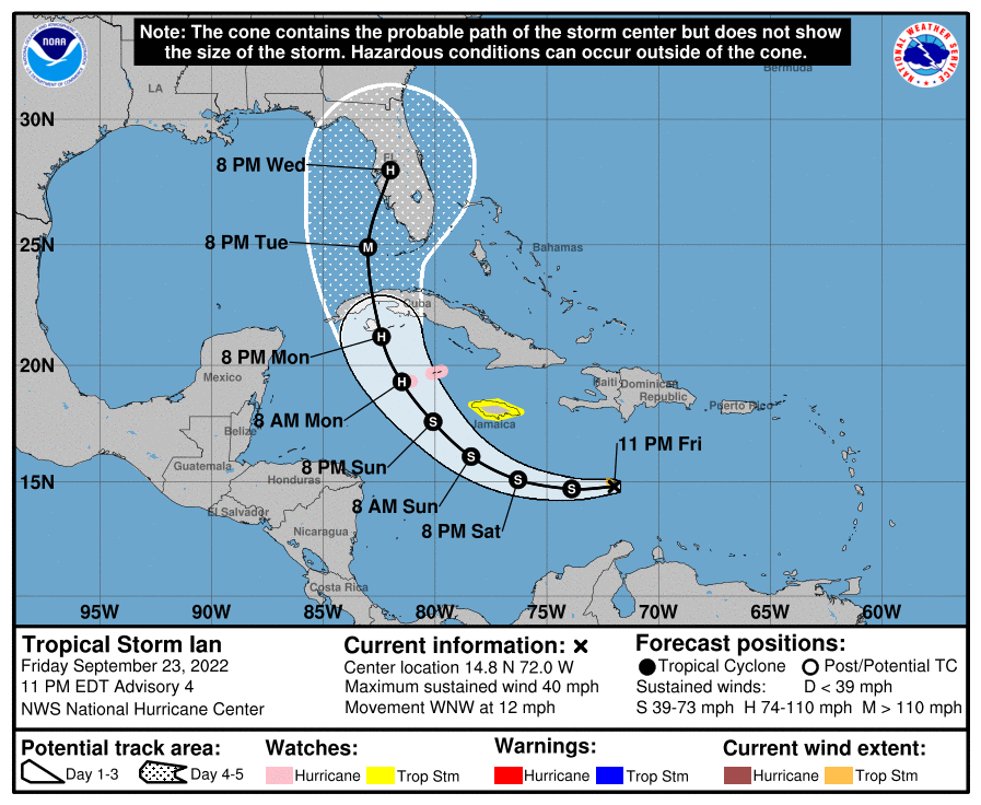
024746_5day_cone_with_line_and_wind.png
回復

使用道具 舉報

簽到天數: 601 天

[LV.9]以壇為家II

霧峰追風者|2022-9-27 10:23 | 顯示全部樓層
699
WTNT44 KNHC 262102 CCA
TCDAT4

Hurricane Ian Discussion Number  15...Corrected
NWS National Hurricane Center Miami FL       AL092022
500 PM EDT Mon Sep 26 2022

Corrected header

Ian continues to strengthen over the northwestern Caribbean Sea. The
last report from the Air Force Hurricane Hunters around 1630 UTC
found 700-mb flight-level winds of 79 kt. The inner core appears
better organized, and the eyewall structure has greatly improved in
radar imagery from the Cayman Islands. The 18 UTC satellite
classifications from SAB and TAFB were a consensus T4.5/77 kt, but
the continued improvement in satellite structure warrants raising
the initial intensity to 85 kt for this advisory.

Atmospheric and oceanic conditions remain very favorable for
additional intensification during the next 24 h or so, as Ian moves
over the very warm waters of the northwestern Caribbean Sea and the
southeastern Gulf of Mexico while the shear remains quite low. The
NHC intensity forecast calls for Ian to become a major hurricane
before it reaches western Cuba early Tuesday. It is then forecast to
reach its peak intensity over the southeastern Gulf of Mexico in 36
h. After that, southwesterly shear in association with a deep-layer
trough over the eastern U.S. is forecast to significantly increase
over the hurricane on Wednesday and Thursday, which will likely
disrupt the vertical structure and import drier air into its
circulation. Despite these less favorable conditions, Ian is still
forecast to remain at or near major hurricane strength as it passes
near the west-central coast of Florida on Wednesday and Thursday.
The NHC intensity forecast agrees well with the latest IVCN and HCCA
aids.

Ian has made an expected turn toward the north-northwest, and its
initial motion is 330/11 kt. The hurricane will move
north-northwestward to northward over the next day or so as it is
steered by a mid-level ridge to the east. A turn to the
north-northeast with a decrease in forward speed is forecast on
Wednesday and Thursday as the center of Ian moves near the west
coast of Florida. The slower forward motion is likely to prolong the
storm surge, wind, and rainfall impacts, especially along the west
coast of Florida. The latest track guidance has come into better
agreement on this scenario, although it is noted that small
deviations to the shore-parallel track could have large implications
on the impacts at particular locations along the west coast of
Florida. The NHC track forecast has again been adjusted slightly
eastward at 48-72 h, which follows the latest trends in the global
model guidance and lies near but just west of the multi-model
consensus aids.

Based on the latest forecast and timing of expected impacts,
Hurricane and Storm Surge Warnings have been issued along the west
coast of Florida.


Key Messages:

1. Life-threatening storm surge, hurricane-force winds, flash
floods and possible mudslides are expected in portions of western
Cuba beginning this evening and continuing into Tuesday.  
Devastating wind damage is possible where the core of Ian moves
across western Cuba. Efforts to protect life and property should be
rushed to completion.

2. There is the danger of life-threatening storm surge along much
of the Florida west coast where a storm surge warning has been
issued, with the highest risk from Fort Myers to the Tampa Bay
region.  Residents in these areas should listen to advice given by
local officials.

3. Hurricane-force winds are expected in the hurricane warning area
in west-central Florida beginning Wednesday morning with tropical
storm conditions expected by late Tuesday.   

4. Heavy rainfall will increase across the Florida Keys and south
Florida Tuesday, spreading to central and northern Florida Wednesday
and Thursday, potentially causing flash, urban and small stream
flooding. Significant prolonged river flooding is likely across
central Florida.


FORECAST POSITIONS AND MAX WINDS

INIT  26/2100Z 20.3N  83.2W   85 KT 100 MPH
12H  27/0600Z 21.7N  83.8W  105 KT 120 MPH
24H  27/1800Z 23.6N  84.0W  115 KT 130 MPH
36H  28/0600Z 25.3N  83.9W  120 KT 140 MPH
48H  28/1800Z 26.7N  83.5W  115 KT 130 MPH
60H  29/0600Z 27.5N  83.2W  100 KT 115 MPH
72H  29/1800Z 28.1N  82.9W   75 KT  85 MPH
96H  30/1800Z 30.1N  82.3W   45 KT  50 MPH...INLAND
120H  01/1800Z 33.5N  82.0W   25 KT  30 MPH...INLAND

$$
Forecaster Reinhart
223342_5day_cone_with_line_and_wind.png 20220927.0140.goes-16.ir.09L.IAN.85kts.965mb.20.8N.83.3W.100pc.jpg
回復

使用道具 舉報

簽到天數: 601 天

[LV.9]以壇為家II

霧峰追風者|2022-9-27 12:41 | 顯示全部樓層
000
WTNT44 KNHC 270258
TCDAT4

Hurricane Ian Discussion Number  16
NWS National Hurricane Center Miami FL       AL092022
1100 PM EDT Mon Sep 26 2022

Ian continues to become better organized on satellite images with
intense deep convection in its Central Dense Overcast and numerous
surrounding banding features.  The overall cloud pattern is quite
symmetric with well-defined upper-level outflow.  Observations from
both Air Force and NOAA Hurricane Hunter aircraft indicate that the
central pressure is falling, and the intensity is increased to 90
kt based on a recently reported 700 mb flight-level wind of 101 kt
from the Air Force plane.  This is also in agreement with a
subjective Dvorak satellite estimate from SAB.

Aside from its relatively brief time passing over western Cuba, Ian
will be moving over waters of very high oceanic heat content during
the next couple of days.  The various Rapid Intensification (RI)
indices show a significant probability of RI and this is reflected
in the short-term official intensity forecast.  However, the SHIPS
guidance, which is based on global model predictions, indicates that
a significant increase in southwesterly shear and a substantially
drying of low- to mid-level air will begin in 24-36 hours.  The NHC
forecast, like the previous one, shows strengthening to Category 4
intensity in a day or so, followed by gradual weakening.  However,
Ian is still expected to be a major hurricane when it reaches the
Florida west coast.  The official intensity forecast is near or
above the latest simple and corrected multi-model consensus
predictions.

Ian continues its north-northwestward trek at about 340/11 kt.  The
hurricane is expected to move north-northwestward to northward
over the southeastern Gulf of Mexico during the next day or so,
along the western periphery of a subtropical ridge.  After around
36 hours, the track forecast becomes more uncertain, since there is
considerable divergence of the track  models in the 2-3 day
time frame.  The guidance also shows considerable slowing of the
forward speed, due to a weakening of the steering currents, when
Ian approaches the west coast of Florida.  This slower forward
motion is likely to prolong the storm surge, wind, and rainfall
impacts, especially along the west coast of Florida.  The official
track forecast is adjusted just slightly east of the previous NHC
prediction based on the latest multi-model consensus aid, TVCN.


Key Messages:

1. Life-threatening storm surge, hurricane-force winds, flash floods
and possible mudslides are expected in portions of western Cuba
beginning overnight and continuing into Tuesday. Devastating wind
damage is possible where the core of Ian moves across western Cuba.
Efforts to protect life and property should be rushed to completion.

2. There is a danger of life-threatening storm surge along much
of the Florida west coast where a storm surge warning has been
issued, with the highest risk from Fort Myers to the Tampa Bay
region.  Residents in these areas should listen to advice given by
local officials.

3. Hurricane-force winds are expected in the hurricane warning area
in west-central Florida beginning Wednesday morning with tropical
storm conditions expected by late Tuesday.

4. Heavy rainfall will spread across western Cuba through Tuesday.  
This will likely produce instances of flash flooding and possible
mudslides in areas of higher terrain over western Cuba.  

5. Heavy rainfall will increase across the Florida Keys and South
Florida Tuesday, spreading into central and northern Florida
Wednesday and Thursday and the Southeast by Friday and Saturday,
potentially causing flash, urban and small stream flooding.
Considerable flooding, including significant, prolonged river
flooding, is likely across Central Florida.


FORECAST POSITIONS AND MAX WINDS

INIT  27/0300Z 21.3N  83.4W   90 KT 105 MPH
12H  27/1200Z 22.8N  83.7W  105 KT 120 MPH
24H  28/0000Z 24.5N  83.7W  120 KT 140 MPH
36H  28/1200Z 26.1N  83.5W  115 KT 130 MPH
48H  29/0000Z 27.2N  83.1W  105 KT 120 MPH
60H  29/1200Z 27.9N  82.7W   95 KT 110 MPH...INLAND
72H  30/0000Z 28.6N  82.4W   65 KT  75 MPH...INLAND
96H  01/0000Z 31.3N  82.2W   30 KT  35 MPH...INLAND
120H  02/0000Z 35.0N  81.5W   25 KT  30 MPH...INLAND

$$
Forecaster Pasch
223342_5day_cone_with_line_and_wind.png recon_AF301-1809A-IAN.png 20222692200-20222700340-GOES16-ABI-AL092022-GEOCOLOR-1000x1000.gif
回復

使用道具 舉報

簽到天數: 3291 天

[LV.Master]伴壇終老

t02436|2022-9-27 23:50 | 顯示全部樓層
已掃過古巴重新出海,下一站襲向佛州。
100939_5day_cone_with_line.png
000
WTNT44 KNHC 271500
TCDAT4

Hurricane Ian Discussion Number  18
NWS National Hurricane Center Miami FL       AL092022
1100 AM EDT Tue Sep 27 2022

The well-defined eye of Ian emerged off the coast of western Cuba
about an hour ago.  Earlier reports from the NOAA Hurricane Hunter
aircraft indicate that Ian strengthened up through landfall, with an
estimated pressure of 947 mb over western Cuba.  While the hurricane
has filled somewhat due to the passage over Cuba, Air Force Reserve
and NOAA Hurricane Hunter data show that it has grown in size.  The
initial wind speed is set to 100 kt.

Ian is moving northward, or 005/9 kt. Dropsonde data from the NOAA
G-IV aircraft indicate a potent upper-level trough is over the
western Gulf of Mexico.  The strength of this trough, the associated
southwesterly flow, and the vertical depth of Ian appear to be the
keys to the forecast.  There has been a notable trend toward the
hurricane remaining more intact up through landfall, meaning Ian is
likely to turn to the northeast and not move as slowly as previously
anticipated.  However, it should be emphasized that this track
remains very uncertain, with a typical spread in the steering
features leading to big speed and track differences down the line,
not to mention the oblique angle of approach to Florida.  The latest
forecast is adjusted to the southeast for this advisory, showing
landfall 6-12 hours faster than before, and we will have to see if
the southern trend continues in the afternoon guidance.  The rest of
the forecast after landfall has been adjusted to the northeast as
well, though it is still slower than the consensus guidance at
longer range.

The hurricane should remain in a favorable environment for
restrengthening over the next day or so while it moves over the warm
waters of the southeastern Gulf of Mexico and in light-shear
conditions.  While the shear should increase by tomorrow, it isn't
expected to be enough to significantly weaken the hurricane before
landfall.  Model guidance is in fairly good agreement on this
scenario, and the NHC intensity forecast continues to call for an
extremely dangerous hurricane landfall for southwestern Florida.

The new forecast necessitates a Hurricane Watch for portions of
extreme southwestern Florida, and a Tropical Storm Watch for the
rest of southeastern Florida that wasn't previously under a watch.
Users are reminded to not focus on the exact track as some
additional adjustments to the track are possible. Significant wind,
storm surge, and rainfall hazards will extend far from the center.


Key Messages:

1. Life-threatening storm surge, hurricane-force winds, flash floods
and possible mudslides are expected to continue in portions of
western Cuba today. Devastating wind damage is expected near the
core of Ian.

2. Life-threatening storm surge looks increasingly likely along much
of the Florida west coast where a storm surge warning is in effect,
with the highest risk from Fort Myers to the Tampa Bay region.
Residents in these areas should listen to advice given by local
officials and follow evacuation orders if made for your area.

3. Hurricane-force winds are expected in the hurricane warning area
in southwest and west-central Florida beginning Wednesday morning
with tropical storm conditions expected by this evening.  Residents
should rush all preparations to completion today.

4. Heavy rainfall will increase across the Florida Keys and south
Florida today, spreading into central and northern Florida tonight
and Wednesday, into the Southeast U.S.  by Thursday and Friday,
likely causing flash, urban, and small stream flooding. Considerable
flooding is expected across central Florida into southern Georgia
and coastal South Carolina, with widespread, prolonged moderate to
major river flooding expected across central Florida.


FORECAST POSITIONS AND MAX WINDS

INIT  27/1500Z 23.0N  83.5W  100 KT 115 MPH
12H  28/0000Z 24.4N  83.3W  115 KT 130 MPH
24H  28/1200Z 26.0N  83.0W  115 KT 130 MPH
36H  29/0000Z 27.1N  82.5W  110 KT 125 MPH
48H  29/1200Z 27.8N  82.1W   75 KT  85 MPH...INLAND
60H  30/0000Z 28.5N  81.7W   60 KT  70 MPH...INLAND
72H  30/1200Z 29.5N  81.5W   50 KT  60 MPH...INLAND
96H  01/1200Z 33.0N  81.8W   35 KT  40 MPH...INLAND
120H  02/1200Z 35.0N  81.5W   25 KT  30 MPH...POST-TROP/EXTRATROP

$$
Forecaster Blake

GOES15412022270yKKAPH.jpg
goes16_truecolor_09L_202209271432.gif
回復

使用道具 舉報

簽到天數: 3822 天

[LV.Master]伴壇終老

甜心|2022-9-28 10:56 | 顯示全部樓層
本帖最後由 甜心 於 2022-9-28 11:01 編輯

這傢伙就是現在國際新聞正在發報即將襲美在德州引發逃難潮的伊恩颶風,目前的強度大概是我們這邊的中颱上限45-48m/s先前古巴因為它災情不輕。
回復

使用道具 舉報

12下一頁
快速回覆
您需要登錄後才可以回帖 登錄 | 立即加入

本版積分規則

霧峰追風者

    主題

    帖子

    221萬

    積分

    16級[四級颶風]

    Rank: 16Rank: 16Rank: 16Rank: 16

16級[四級颶風]

發訊息

本平台僅供學術討論之用,預報應以氣象局為準

威普網站虛擬主機贊助公司

臺灣第一個天氣類型社群平台 即時天氣資訊、精準颱風動態

線上客服
FB傳送訊息
廣告行銷
精準行銷 物超所值
官方粉專
發佈 快速回復 返回頂部 返回列表