開啟輔助訪問
 找回密碼
 立即加入

07L.Fiona

簽到天數: 2414 天

[LV.Master]伴壇終老

2022-9-13 21:44 | 顯示全部樓層
基本資料  
編號    :07 L
擾動編號日期:2022 09 13 20
撤編日期  :2022 00 00 00
96L.INVEST.15kts.1011mb.14.8N.44.3W

20220913.1240.goes-16.vis.2km.96L.INVEST.15kts.1011mb.14.8N.44.3W.pc.jpg

1. Central Tropical Atlantic:
Conventional and Low-earth orbit satellite data indicate that
showers and thunderstorms associated with a tropical wave located
about midway between the west coast of Africa and the Windward
Islands have increased and become better organized since yesterday
afternoon.  Further development of this system is possible and a
tropical depression could form over the next several days while it
generally moves westward to west-northwestward over the central
tropical Atlantic and approaches the Leeward Islands on Friday.
* Formation chance through 48 hours...low...30 percent.
* Formation chance through 5 days...medium...40 percent.

two_atl_2d1.png

評分

參與人數 1水氣能量 +15 +1 收起 理由
t02436 + 15 + 1

查看全部評分

回復

使用道具 舉報

簽到天數: 3291 天

[LV.Master]伴壇終老

t02436|2022-9-14 23:18 | 顯示全部樓層
000
WTNT42 KNHC 141500
TCDAT2

Tropical Depression Seven Discussion Number   1
NWS National Hurricane Center Miami FL       AL072022
1100 AM AST Wed Sep 14 2022

Visible satellite imagery shows that the circulation associated
with the area of low pressure in the tropical Atlantic has become
better defined.  The associated convection has persisted overnight
and this morning, and although it is confined to the eastern
portion of the circulation it has enough organization to classify
the system as a tropical depression.  The initial intensity is set
at 30 kt, which is a little above the latest TAFB Dvorak
classification of T1.5, but in line with overnight scatterometer
data.

Moderate westerly shear and a dry mid-level atmosphere are expected
to prevent significant intensification, but some modest
strengthening is possible over the next day or two, and the NHC
forecast calls for the depression to become a tropical storm tonight
or Thursday. After the system moves into the eastern Caribbean, the
westerly shear is forecast to increase somewhat and the global
models suggest that the system could struggle to maintain its
closed circulation after that time.  The NHC intensity forecast is
a little above the IVCN intensity forecast, and maintains the
system as a tropical cyclone through the forecast period.  Weakening
is indicated by day 5 when the system is forecast to interact with
Hispaniola.

The depression is moving westward or 280/12 kt.  The cyclone is
forecast to move slightly north of due westward along the south
side of a low to mid-level ridge that is anchored over the central
and western Atlantic.  Although the track guidance is tightly
clustered, there are some differences in forward speed with the
ECMWF much faster than the GFS.  The NHC forecast lies near the
middle of the guidance envelope and is near the TVCA and GFEX
consensus aids to account for the differences in the forward speed.

Key Messages:

1.  The system is expected to move through the Leeward Islands on
Friday or Friday night, bringing heavy rainfall and possible wind
impacts. Interests in the Leeward Islands should monitor the
progress of the depression as tropical storm watches could be
required for some islands later today.

2.  The system could move near or over portions of the Virgin
Islands, Puerto Rico, and Hispaniola this weekend and early next
week, potentially bringing heavy rainfall and some wind impacts to
these areas, and interests there should monitor the progress of the
depression.


FORECAST POSITIONS AND MAX WINDS

INIT  14/1500Z 16.6N  49.6W   30 KT  35 MPH
12H  15/0000Z 16.7N  51.5W   35 KT  40 MPH
24H  15/1200Z 16.8N  53.9W   40 KT  45 MPH
36H  16/0000Z 16.9N  56.5W   40 KT  45 MPH
48H  16/1200Z 17.0N  59.3W   40 KT  45 MPH
60H  17/0000Z 17.1N  62.0W   40 KT  45 MPH
72H  17/1200Z 17.4N  64.6W   40 KT  45 MPH
96H  18/1200Z 18.0N  68.5W   40 KT  45 MPH
120H  19/1200Z 19.1N  71.7W   30 KT  35 MPH...INLAND

$$
Forecaster Brown
150210_5day_cone_with_line.png
回復

使用道具 舉報

簽到天數: 3291 天

[LV.Master]伴壇終老

t02436|2022-9-15 18:49 | 顯示全部樓層
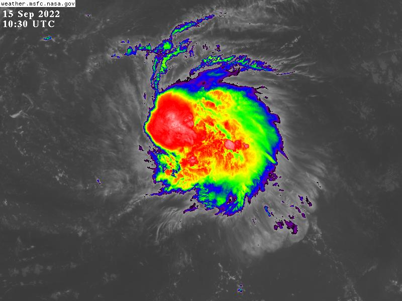
00Z已命名Fiona。
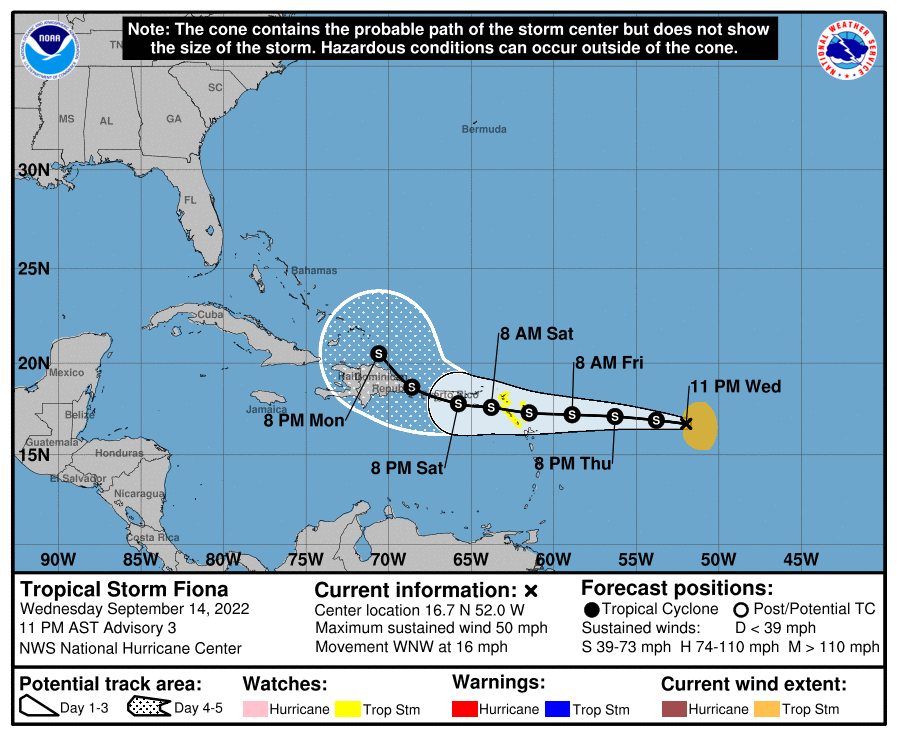
024315_5day_cone_with_line_and_wind.png
000
WTNT42 KNHC 150241
TCDAT2

Tropical Storm Fiona Discussion Number   3
NWS National Hurricane Center Miami FL       AL072022
1100 PM AST Wed Sep 14 2022

Although the system still appears ragged-looking in satellite
images, a very recent ASCAT-B pass indicated that the tropical
cyclone has strengthened.  Maximum winds in the pass were around 45
kt and therefore, the initial intensity has been increased to that
value. It should be noted that Fiona is an asymmetric storm with all
of its thunderstorms and strong winds currently located on the
system's east side.  The lopsided structure is due to moderate
west-southwesterly vertical wind shear.

Fiona continues to move westward at 12 kt. The steering pattern
seems relatively straightforward.  A low- to mid-level subtropical
ridge situated over the central Atlantic should steer the system
westward to west-northwestward during the next several days, taking
the cyclone across the northern Leeward Islands by Friday night,
near the Virgin Islands and Puerto Rico on Saturday, and near
Hispaniola on Sunday and Monday.  There will likely be a turn to the
northwest by the end of the period when the system reaches the
western periphery of the ridge.  The models all show a similar
theme, but there are notable speed differences with the ECMWF model
faster than the remainder of the guidance.  The NHC track forecast
is quite similar to the previous one and near a consensus of the GFS
and ECMWF models.

Given the current tilted and asymmetric structure, continued
influences of shear, and some dry air, any strengthening of the
storm will likely be slow to occur during the next day or so.
However, some of the models show Fiona moving into a less hostile
environment in a couple of days, and it could have an opportunity to
become a little stronger this weekend if it avoids the landmasses of
Puerto Rico and Hispaniola.  Given the uncertainty of the system's
future environment and potential land interaction, little change in
strength is shown through most of the period. However, it should be
noted that the intensity forecast is of low confidence given those
complexities.

Key Messages:

1. Tropical storm conditions are possible in portions of the
northern Leeward Islands by Friday night, where a Tropical Storm
Watch has been issued.

2. Heavy rains will begin to affect the northern Leeward Islands
late Friday, spreading into the British and U.S. Virgin Islands and
Puerto Rico over the weekend. This rainfall may produce isolated
flash and urban flooding, along with isolated mudslides in areas of
higher terrain.

3. Fiona is expected to move near the Virgin Islands, Puerto Rico,
and Hispaniola this weekend and early next week, and Tropical Storm
Watches will likely be issued for some of those areas on Thursday.


FORECAST POSITIONS AND MAX WINDS

INIT  15/0300Z 16.7N  52.0W   45 KT  50 MPH
12H  15/1200Z 16.9N  53.8W   45 KT  50 MPH
24H  16/0000Z 17.1N  56.3W   50 KT  60 MPH
36H  16/1200Z 17.2N  58.9W   50 KT  60 MPH
48H  17/0000Z 17.3N  61.5W   50 KT  60 MPH
60H  17/1200Z 17.6N  63.8W   50 KT  60 MPH
72H  18/0000Z 17.8N  65.8W   50 KT  60 MPH
96H  19/0000Z 18.7N  68.6W   50 KT  60 MPH...INLAND
120H  20/0000Z 20.5N  70.6W   50 KT  60 MPH

$$
Forecaster Cangialosi
GOES10302022258EzqfNI.jpg
回復

使用道具 舉報

簽到天數: 601 天

[LV.9]以壇為家II

霧峰追風者|2022-9-20 10:28 | 顯示全部樓層
強度已升C2 ( 95kts ),巔峰上望C4。
07L FIONA 220920 0000 20.3N 70.1W ATL 95 974
al072022.20220919212152.gif 20220920.0200.goes-16.ir.07L.FIONA.95kts.974mb.20.3N.70.1W.100pc.jpg 20220919.2140.goes-16.vis.2km.07L.FIONA.85kts.972mb.19.6N.69.5W.pc.jpg 07L_BD (1).png
回復

使用道具 舉報

簽到天數: 601 天

[LV.9]以壇為家II

霧峰追風者|2022-9-21 10:22 | 顯示全部樓層
00Z強度升到C3上限( 110KT ),逐漸北上。
07L FIONA 220921 0000 22.9N 71.8W ATL 110 951
20220921.0140.goes-16.ir.07L.FIONA.110kts.951mb.22.9N.71.8W.100pc.jpg 20220920.2250.f17.ir.olsircomp.07L.FIONA.x.jpg
回復

使用道具 舉報

簽到天數: 601 天

[LV.9]以壇為家II

霧峰追風者|2022-9-21 19:03 | 顯示全部樓層
強度升C4,逐漸北上。
000
WTNT42 KNHC 210924
TCDAT2

Hurricane Fiona Discussion Number  28
NWS National Hurricane Center Miami FL       AL072022
500 AM EDT Wed Sep 21 2022

An Air Force Reserve Hurricane Hunter aircraft has recently
reported 700-mb flight-level winds of 128 kt, and reliable surface
winds estimates from the SFMR of 115 kt.  The central pressure
inside the 25 n mi wide eye has fallen to 939 mb.  Based on these
data, the initial intensity is set at 115 kt, making Fiona a
category 4 hurricane on the Saffir-Simpson Hurricane Wind Scale.

There is little change to the intensity forecast philosophy since
the last advisory. The vertical wind shear over Fiona is expected
to remain low to moderate during the next couple of days.  During
that time, the hurricane will be traversing warm sea surface
temperatures and remain in a moist environment.  These conditions
should allow for some additional strengthening during the next 12
to 24 hours, and the new intensity forecast calls for a peak
intensity of 120 kt during that time.  After that time, difficult-
to-predict eyewall replacement cycles are likely to cause some
fluctuations in intensity.  Starting near 72 h, Fiona is expected
to
interact with a vigorous mid-latitude trough, which should lead to
transition into an intense extratropical low between 72-96 h.  
After 96 h, the system is expected to weaken.

The initial motion is now 360/7.  Fiona should move generally
northward around the western periphery of a mid-level ridge during
the next 12-24 hours.  After that time, the hurricane is forecast
to turn north-northeastward and begin to gradually accelerate as
the aforementioned trough approaches from the northwest.  There
were no no significant changes to the guidance from the last
advisory, and the new forecast track is an update of the previous
track.


Key Messages:

1.  Heavy rains south of Fiona will continue to impact the Turks and
Caicos through this morning with additional flooding possible.

2. Tropical storm conditions are possible on Bermuda by late
Thursday.

3. Fiona is expected to affect portions of Atlantic Canada as a
powerful hurricane-force cyclone late Friday and Saturday, and could
produce significant impacts from high winds, storm surge, and heavy
rainfall. Interests in these areas should closely monitor the
progress of Fiona and updates to the forecast.


FORECAST POSITIONS AND MAX WINDS

INIT  21/0900Z 23.9N  71.8W  115 KT 130 MPH
12H  21/1800Z 25.0N  71.7W  120 KT 140 MPH
24H  22/0600Z 26.9N  71.1W  120 KT 140 MPH
36H  22/1800Z 29.3N  69.8W  120 KT 140 MPH
48H  23/0600Z 32.3N  67.4W  120 KT 140 MPH
60H  23/1800Z 36.5N  63.3W  115 KT 130 MPH
72H  24/0600Z 42.0N  60.9W  105 KT 120 MPH
96H  25/0600Z 50.0N  60.0W   60 KT  70 MPH...POST-TROP/EXTRATROP
120H  26/0600Z 56.0N  59.0W   40 KT  45 MPH...POST-TROP/EXTRATROP

$$
Forecaster Beven

101208_5day_cone_no_line_and_wind.png 20220921.1030.goes-16.ir.07L.FIONA.115kts.942mb.23.5N.71.8W.100pc.jpg
回復

使用道具 舉報

簽到天數: 582 天

[LV.9]以壇為家II

蜜露|2022-9-23 12:00 | 顯示全部樓層


recon_AF306-2507A-FIONA.png

recon_AF306-2507A-FIONA_timeseries.png

大西洋的颶風那裡是有實測的,怎麼沒有人發阿
強度差不多是Cat.4 邊緣

他在多明尼加共和國的陸地上開始逐漸增強北上.


回復

使用道具 舉報

快速回覆
您需要登錄後才可以回帖 登錄 | 立即加入

本版積分規則

0908morakot

    主題

    帖子

    69萬

    積分

    12級[颶風Hurricane]

    Rank: 12Rank: 12Rank: 12

12級[颶風Hurricane]

發訊息

本平台僅供學術討論之用,預報應以氣象局為準

威普網站虛擬主機贊助公司

臺灣第一個天氣類型社群平台 即時天氣資訊、精準颱風動態

線上客服
FB傳送訊息
廣告行銷
精準行銷 物超所值
官方粉專
發佈 快速回復 返回頂部 返回列表