開啟輔助訪問
 找回密碼
 立即加入

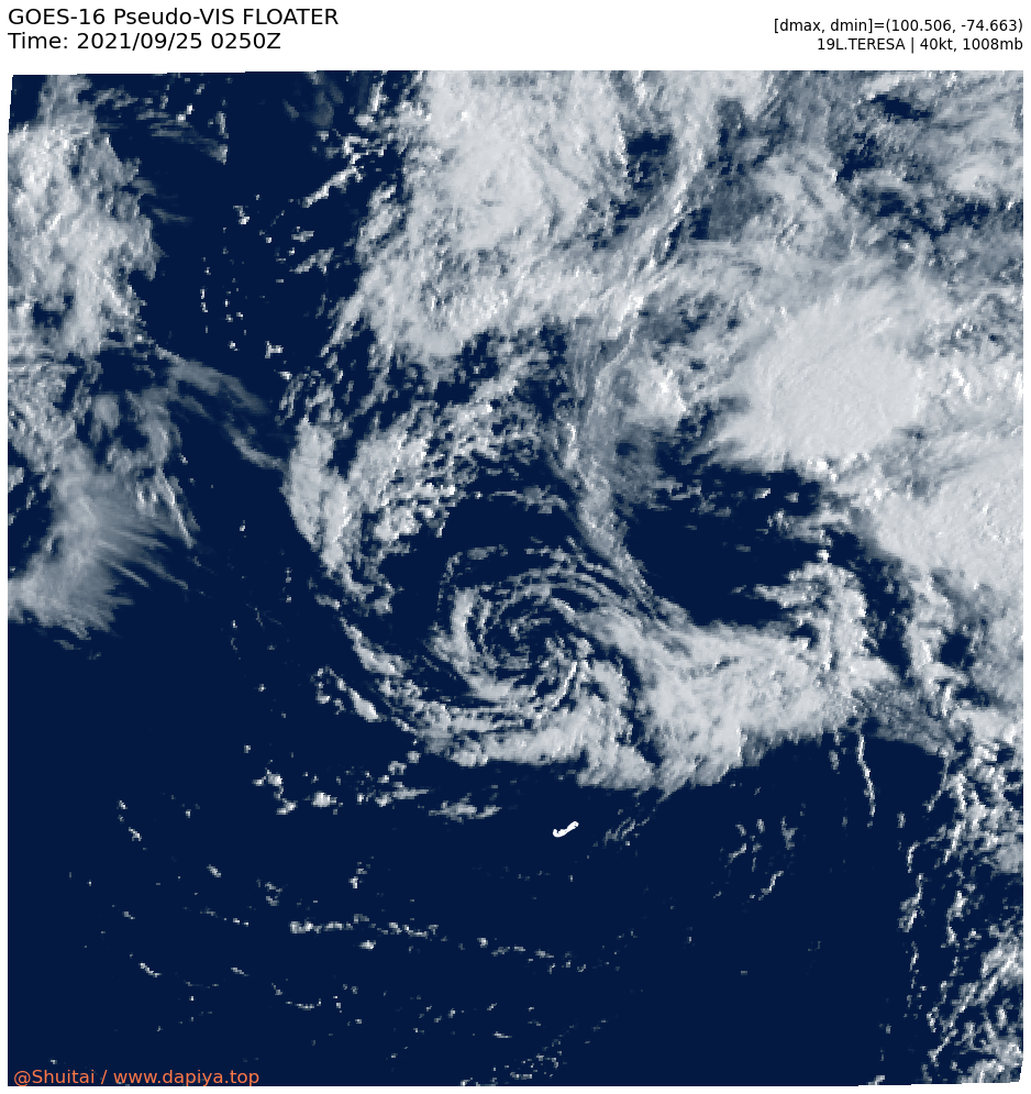
19L.Teresa 副熱帶風暴 加速東北行

簽到天數: 1650 天

[LV.Master]伴壇終老

2021-9-24 19:23 | 顯示全部樓層
  副熱帶風暴  
編號:19 L
名稱:Teresa
19L_BAND01.png
  基本資料  
擾動編號日期:2021 09 24 19
命名日期  :2021 09 25 05
撤編日期  :2021 09 26 20
登陸地點  :


  巔峰時期資料  
近中心最強風速 :40  kt (
SS )
海平面最低氣壓 :1008 百帕

  擾動編號資料  

99L.INVEST.15kts.1005mb.28N.59W
20210924.1040.goes-16.ir.99L.INVEST.15kts.1005mb.28N.59W.100pc.jpg

  NHC:20%
2. A large area of showers and thunderstorms centered a couple of
hundred miles east of Bermuda is associated with a surface and
upper-level trough.  Some tropical or subtropical development
of this system could occur through early Saturday as it moves
generally north-northwestward.  After that time, development
is not expected due to strong upper-level winds.
* Formation chance through 48 hours...low...20 percent.
* Formation chance through 5 days...low...20 percent.

two_atl_2d2 (20).png two_atl_5d2 (19).png 以上資料來自:NHC、颱風論壇整理製作

評分

參與人數 1水氣能量 +15 +1 收起 理由
king111807 + 15 + 1 熱帶擾動首帖

查看全部評分

回復

使用道具 舉報

簽到天數: 3198 天

[LV.Master]伴壇終老

king111807|2021-9-24 21:07 | 顯示全部樓層
NHC展望提升至Medium,40%
1. A large area of showers and thunderstorms centered a couple
hundred miles east of Bermuda is associated with a formative surface
low interacting with an upper-level trough.  Additional tropical or
subtropical development of this system could occur through early
Saturday as it moves generally north-northwestward.  After that
time, development is not expected due to strong upper-level winds.
Additional information on this system, including gale warnings, can
be found in High Seas Forecasts issued by the National Weather
Service.
* Formation chance through 48 hours...medium...40 percent.
* Formation chance through 5 days...medium...40 percent.
two_atl_2d1.png
回復

使用道具 舉報

簽到天數: 3198 天

[LV.Master]伴壇終老

king111807|2021-9-25 03:35 | 顯示全部樓層
NHC提升展望至High,70%
1. Surface observations and recent satellite wind data indicate that a
surface low located a couple hundred miles north-northeast of
Bermuda is gradually becoming better defined as it interacts with an
upper-level trough. This system is producing winds of 40 to 45 mph
north of the low center and additional development into a
subtropical or tropical storm appears likely. Advisories could be
initiated as soon as this afternoon as the system moves slowly
toward the north-northwest over the next day or so. Additional
information on this system, including gale warnings, can be found in
High Seas Forecasts issued by the National Weather Service.
* Formation chance through 48 hours...high...70 percent.
* Formation chance through 5 days...high...70 percent.
two_atl_2d1.png
回復

使用道具 舉報

簽到天數: 3198 天

[LV.Master]伴壇終老

king111807|2021-9-25 03:40 | 顯示全部樓層
FWC-N發布TCFA
SUBJ/TROPICAL CYCLONE FORMATION ALERT (99L)//
WTNT21 KNGU 241900
RMKS/
1. FORMATION OF A SUBTROPICAL OR TROPICAL CYCLONE IS POSSIBLE WITHIN
100 NM EITHER SIDE OF A LINE FROM 32.6N 62.8W TO 37.6N 64.8W
WITHIN THE NEXT 24 HOURS. AVAILABLE DATA DOES NOT JUSTIFY
ISSUANCE OF NUMBERED TROPICAL CYCLONE WARNINGS AT THIS TIME.
WINDS IN THE AREA ARE ESTIMATED TO BE 25 TO 30 KNOTS. METSAT
IMAGERY AT 241200Z INDICATES THAT A CIRCULATION CENTER IS LOCATED
NEAR 32.6N 62.8W. THE SYSTEM IS MOVING NORTH-NORTHWESTWARD AT 12
KNOTS.
2. RECENT SHIP OBSERVATIONS AND
SATELLITE-DERIVED SURFACE WIND DATA INDICATE THAT A NON-TROPICAL
UPPER-LEVEL LOW WELL NORTH-NORTHEAST OF BERMUDA HAS DEVELOPED A
SURFACE CIRCULATION WITH ASSOCIATED GALE FORCE WINDS IN THE NORTH
SEMICIRCLE OF THE SYSTEM. FURTHER DEVELOPMENT IS LIKELY AND THE
LOW COULD BECOME A SUBTROPICAL OR TROPICAL STORM LATER TODAY OR
TONIGHT. THE SYSTEM IS EXPECTED TO DRIFT GENERALLY NORTH-
NORTHWESTWARD TO NORTHWARD THROUGH THE WEEKEND AND MERGE WITH A
LARGER LOW PRESSURE SYSTEM SOUTHEAST OF NOVA SCOTIA BY SUNDAY
NIGHT, EARLY MONDAY MORNING.
3. THIS ALERT WILL BE REISSUED, UPGRADED TO A WARNING, OR
CANCELLED. BY 251900Z.//
BT
al992021.gif
回復

使用道具 舉報

簽到天數: 3198 天

[LV.Master]伴壇終老

king111807|2021-9-25 11:28 | 顯示全部樓層
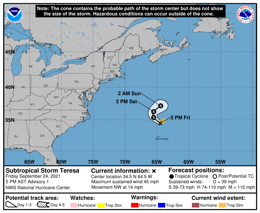
NHC升格SS,命名Teresa
WTNT44 KNHC 242056
TCDAT4

Subtropical Storm Teresa Discussion Number   1
NWS National Hurricane Center Miami FL       AL192021
500 PM AST Fri Sep 24 2021

The disturbance just north of Bermuda interacting with a mid- to
upper-level low has developed a prominent band of deep convection
within its eastern semicircle as well as a well-defined surface
center. Additionally, the system is not displaying any significant
baroclinicity (i.e., frontal boundaries), so it is not an
extratropical cyclone.  All of which indicates that the system has
evolved into a subtropical cyclone. ASCAT-C scatterometer data from
1440Z suggested peak winds were around 40 kt, which is the basis
for calling the system Subtropical Storm Teresa.

The system is moving toward the northwest at 12 kt is it rounds the
northern part of the mid- to upper-level low.  By Saturday, Teresa
should turn northward and then northeastward, as it begins to be
caught up in the mid-latitude westerlies. The forecast is based upon
the TVCN track consensus technique.

Teresa will not be long-lived.  A  developing extratropical system
forming off of New England should absorb Teresa between 36 and 48
hours.  Until then, the subtropical storm has a small window to
intensify slightly while traversing lukewarm water and
encountering moderate vertical shear.  If deep convection develops
near the system's center, then Teresa could evolve into a tropical
storm.  However, it is more likely that Teresa will remain a
subtropical storm until dissipation in around two days.

It is worth noting that Teresa will likely be the 9th so-called
"shortie" of the 2021 hurricane season -- systems that are short-
lived and relatively weak.

FORECAST POSITIONS AND MAX WINDS

INIT  24/2100Z 34.5N  64.5W   40 KT  45 MPH
12H  25/0600Z 35.4N  65.5W   45 KT  50 MPH
24H  25/1800Z 36.3N  65.5W   45 KT  50 MPH
36H  26/0600Z 37.2N  64.4W   40 KT  45 MPH
48H  26/1800Z...DISSIPATED

$$
Forecaster Landsea
062533t7we4gkq350h47gk.png
19L_BAND01.png
回復

使用道具 舉報

快速回覆
您需要登錄後才可以回帖 登錄 | 立即加入

本版積分規則

本平台僅供學術討論之用,預報應以氣象局為準

威普網站虛擬主機贊助公司

臺灣第一個天氣類型社群平台 即時天氣資訊、精準颱風動態

線上客服
FB傳送訊息
廣告行銷
精準行銷 物超所值
官方粉專
發佈 快速回復 返回頂部 返回列表