1. A broad area of low pressure located over 700 miles south of the
southern tip of the Baja California Peninsula continues to produce
disorganized showers and thunderstorms. Environmental conditions
remain favorable for development, and a tropical depression is
likely to form during the next couple of days as the system moves
west-northwestward or northwestward, well offshore of the coast of
Mexico.
* Formation chance through 48 hours...high...70 percent.
* Formation chance through 5 days...high...90 percent.
WTPN21 PHNC 021500
MSGID/GENADMIN/JOINT TYPHOON WRNCEN PEARL HARBOR HI//
SUBJ/TROPICAL CYCLONE FORMATION ALERT (INVEST 97E)//
RMKS/
1. FORMATION OF A SIGNIFICANT TROPICAL CYCLONE IS POSSIBLE WITHIN
140 NM EITHER SIDE OF A LINE FROM 11.8N 110.8W TO 13.2N 116.0W
WITHIN THE NEXT 12 TO 24 HOURS. AVAILABLE DATA DOES NOT JUSTIFY
ISSUANCE OF NUMBERED TROPICAL CYCLONE WARNINGS AT THIS TIME.
WINDS IN THE AREA ARE ESTIMATED TO BE 15 TO 20 KNOTS. METSAT
IMAGERY AT 021200Z INDICATES THAT A CIRCULATION CENTER IS LOCATED
NEAR 12.0N 111.5W. THE SYSTEM IS MOVING WEST-NORTHWESTWARD AT 10
KNOTS.
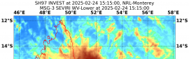
2. REMARKS: AN AREA OF CONVECTION (INVEST 97E) HAS PERSISTED NEAR
12.0N 111.5W, APPROXIMATELY 397 NM SOUTH OF SOCORRO ISLAND. ANIMATED
MULTISPECTRAL IMAGERY (MSI) AND A 021136Z SSMIS 91GHZ SATELLITE
IMAGE DEPICT A BROAD CIRCULATION WITH LOW LEVEL TURNING AND AREAS OF
CONVECTION DISPLACED TO THE NORTH AND SOUTH OF THE CIRCULATION.
INVEST 97E IS IN AN ENVIRONMENT THAT IS FAVORABLE FOR DEVELOPMENT
WITH LOW (<15 KNOTS) VERTICAL WIND SHEAR (VWS), WARM (29-30C) SEA
SURFACE TEMPERATURES AND FAIR POLEWARD OUTFLOW ALOFT. MAXIMUM
SUSTAINED SURFACE WINDS ARE ESTIMATED AT 15 TO 20 KNOTS. MINIMUM SEA
LEVEL PRESSURE IS ESTIMATED TO BE NEAR 1007 MB. THE POTENTIAL FOR
THE DEVELOPMENT OF A SIGNIFICANT TROPICAL CYCLONE WITHIN THE NEXT 24
HOURS IS HIGH.
3. THIS ALERT WILL BE REISSUED, UPGRADED TO WARNING OR CANCELLED BY
031500Z.//
NNNN
1. Satellite imagery indicates that low pressure centered about 700
miles south-southwest of the southern tip of the Baja California
Peninsula has become significantly better organized today, with
increased shower and thunderstorm activity noted near its low-level
center. If current trends continue, advisories will be initiated
later this afternoon or tonight. This system is expected to move
generally northwestward during the next couple of days.
* Formation chance through 48 hours...high...near 100 percent.
* Formation chance through 5 days...high...near 100 percent.
Tropical Storm Odalys Discussion Number 1
NWS National Hurricane Center Miami FL EP202020
200 PM PDT Tue Nov 03 2020
The low pressure area well south-southwest of the southern tip of
the Baja California Peninsula has become significantly better
organized today. A curved band of deep convection is noted to the
northwest of the low-level center, and a second weaker band is
located to its southeast. Satellite-derived wind data indicate the
low-level center is still somewhat broad, but it appears to have
enough definition to justify starting advisories as a tropical
cyclone. Recent ASCAT-B data show numerous 30+ kt wind barbs, with
a couple barbs peaking at 33-34 kt in the eastern semicircle of the
cyclone. Considering known under-sampling issues with this data
source, the initial intensity is set at 35 kt, which is consistent
with a T2.5 subjective Dvorak classification from TAFB. Thus, the
system has become a tropical storm, and advisories are initiated on
Tropical Storm Odalys.
Weak to moderate vertical wind shear and sufficient oceanic heat
content may support modest strengthening during the next 12 h or so.
By 24-36 h, strong southwesterly deep-layer shear associated with an
approaching shortwave trough to the northwest, along with intrusions
of drier mid-level air, will induce a steady and perhaps rapid
weakening trend. The system is forecast to weaken to a depression by
48 h and a remnant low by 96 h, but this could occur even sooner if
the stronger shear values noted in the SHIPS guidance are realized.
The GFS simulated satellite imagery suggests the system could be
devoid of deep convection as early as day 3 of the forecast period.
The storms estimated motion is a somewhat uncertain 295/11 kt. A
slight increase in forward speed is expected during the next couple
of days as Odalys is steered northwestward by a low- to mid-level
ridge centered over southern Texas and northern Mexico. Then, the
cyclone should gradually slow down and turn westward as this ridge
weakens due to the aforementioned shortwave trough. By 72 h, the
storm will be steered southwestward by another low- to mid-level
ridge building to its northwest. The track models are in decent
agreement, and the official NHC track forecast lies near the center
of the guidance envelope closest to the track consensus aids.


.png")
.png")
 提升卡
提升卡 千斤頂
千斤頂


 t
t