開啟輔助訪問
 找回密碼
 立即加入

17L.Paulette 高緯南落 冷心轉暖重回TS

簽到天數: 1650 天

[LV.Master]伴壇終老

2020-9-5 01:44 | 顯示全部樓層
  二級颶風  
編號:17 L
名稱:Pauiette
015640trvwlf8tu7fbffvj.jpg
  基本資料  
擾動編號日期:2020 09 05 01
命名日期  :2020 09 07 23
撤編日期  :2020 09 24 19

二次撤編日期202009 2801
登陸地點  :

  巔峰時期資料  
近中心最強風速 :90 kt ( Cat.2 )
海平面最低氣壓 :970 百帕
  擾動編號資料  
92L.INVEST.25kts-1009mb-15.2N-25.2W
20200904.1700.goes-16.ir.92L.INVEST.25kts.1009mb.15.2N.25.2W.100pc.jpg

  NHC:40%
3. A tropical wave and area of low pressure located just west of the
Cabo Verde Islands is producing a large area of disorganized
showers and thunderstorms.  Gradual development of this system is
expected as it moves westward to west-northwestward, and a tropical
depression is likely to form late this weekend or early next week
when the system reaches the central tropical Atlantic.
* Formation chance through 48 hours...medium...40 percent.
* Formation chance through 5 days...high...80 percent.

two_atl_2d3.png two_atl_5d3.png
以上資料來自:NHC、颱風論壇整理製作

評分

參與人數 1水氣能量 +15 +1 收起 理由
周子堯@FB + 15 + 1 熱帶擾動首帖

查看全部評分

回復

使用道具 舉報

簽到天數: 1650 天

[LV.Master]伴壇終老

老農民版夜神月|2020-9-5 03:13 | 顯示全部樓層
本帖最後由 老農民版夜神月 於 2020-9-11 08:53 編輯

數值預報目前看好92L(圖1最左邊的系統)後期將有一定程度的發展
ecmwf_mslp_uv850_eatl_fh24-216.gif 92L_gefs_latest.png

回復

使用道具 舉報

簽到天數: 1650 天

[LV.Master]伴壇終老

老農民版夜神月|2020-9-6 02:11 | 顯示全部樓層
本帖最後由 老農民版夜神月 於 2020-9-6 02:13 編輯

NHC展望提升至60%/90%
1. A tropical wave and area of low pressure located over the eastern
tropical Atlantic continues to produce a large area of
disorganized showers and thunderstorms.  Gradual development of
this system is expected while it moves westward to
west-northwestward, and a tropical depression is likely to form late
this weekend or early next week when the system reaches the central
tropical Atlantic.
* Formation chance through 48 hours...medium...60 percent.
* Formation chance through 5 days...high...90 percent.

two_atl_2d1.png two_atl_5d1.png goes16_ir_92L_202009051535.gif

回復

使用道具 舉報

簽到天數: 1650 天

[LV.Master]伴壇終老

老農民版夜神月|2020-9-7 02:26 | 顯示全部樓層
FWC-N已發布TCFA,NHC展望提升至90%
EC十分看好其後期強度發展
WTNT21 KNGU 061300
SUBJ/TROPICAL CYCLONE FORMATION ALERT//
REF/A/FLEWEACEN NORFOLK VA/061300Z SEP 20//
AMPN/REF IS TROPICAL CYCLONE FORMATION ALERT (WTNT21 KNGU 061300)//
RMKS/1. FORMATION OF A SIGNIFICANT TROPICAL CYCLONE IS POSSIBLE WITHIN
100 NM EITHER SIDE OF A LINE FROM 18.7N 38.0W TO 19.1N 42.4W
WITHIN THE NEXT 00 TO 24 HOURS. AVAILABLE DATA DOES NOT JUSTIFY
ISSUANCE OF NUMBERED TROPICAL CYCLONE WARNINGS AT THIS TIME.
WINDS IN THE AREA ARE ESTIMATED TO BE 25 TO 30 KNOTS. METSAT
IMAGERY AT 060600Z INDICATES THAT A CIRCULATION CENTER IS LOCATED
NEAR 18.7N 38.0W. THE SYSTEM IS MOVING WEST-NORTHWESTWARD AT 10
KNOTS.
2. THE SURFACE CIRCULATION ASSOCIATED WITH A LOW PRESSURE SYSTEM
LOCATED ABOUT MIDWAY BETWEEN THE LEEWARD ISLANDS AND THE WEST
COAST OF AFRICA IS SLOWLY BECOMING BETTER DEFINED. SHOWERS AND
THUNDERSTORMS ASSOCIATED WITH THE LOW CONTINUE TO INCREASE AND A
TROPICAL DEPPRESSION IS LIKELY TO FORM DURING THE NEXT 24 HOURS AS
IT MOVES GENERALLY WESTWARD ACROSS THE CENTRAL TROPICAL ATLANTIC.
3. THIS ALERT WILL BE REISSUED, UPGRADED TO WARNING OR CANCELLED BY 071300Z.//

al992020.20200830194257.gif
1. An area of low pressure located about midway between the west coast
of Africa and the Leeward Islands is gradually becoming better
defined.  However, the associated showers and thunderstorms are
still not well organized.  Gradual development of this system is
expected, and a tropical depression is likely to form tonight or on
Monday while it moves westward or west-northwestward across the
central tropical Atlantic.
* Formation chance through 48 hours...high...90 percent.
* Formation chance through 5 days...high...90 percent.

two_atl_2d1.png 未命名.png
ecmwf_mslp_uv850_watl_11.png


評分

參與人數 1水氣能量 +15 收起 理由
king111807 + 15 TCFA

查看全部評分

回復

使用道具 舉報

簽到天數: 3279 天

[LV.Master]伴壇終老

t02436|2020-9-7 11:20 | 顯示全部樓層
03Z升格17L,巔峰上望55節。

306
WTNT42 KNHC 070237
TCDAT2

Tropical Depression Seventeen Discussion Number   1
NWS National Hurricane Center Miami FL       AL172020
1100 PM AST Sun Sep 06 2020

The tropical low that the National Hurricane Center has been
tracking the past few days west of the Cabo Verde Islands has
developed enough convective banding for the system to be classified
as a tropical depression. A 06/2345Z ASCAT-B scatterometer pass
indicated surface wind speeds of 30-31 kt north of the center, which
are supported by a T2.0/30 kt Dvorak satellite intensity estimate
from TAFB at 07/0000 UTC.

The initial motion estimate is an uncertain 270/04kt. The center has
been jumping around somewhat due to small, brief convective bursts
that then dissipate, leaving small swirls rotating around the mean
circulation center. However, the latest ASCAT data showed a much
better defined overall circulation, especially in the inner core
wind field region, so the forward motion should stabilize fairly
soon. The depression is expected to remain caught in weak steering
flow for the next 5 days, so only a slow westward motion is expected
tonight and Monday, followed by a west-northwestward motion by later
Monday and Tuesday that will continue through the remainder of the
120-h forecast period. Possible track forecast complications could
develop by days 3-5 if binary interaction occurs between the
depression and the large low (Invest 93L) currently located
southeast of the Cabo Verde Islands, resulting in TD-17 not gaining
as much latitude as currently indicated. The NHC forecast track lies
down the middle of the simple- and corrected-consensus model
guidance envelope.

The depression is only forecast to slowly strengthen for the next 4
days or so due to expected intrusions of dry mid-level air. By day
5, increasing southerly vertical wind shear on the east side of a
large upper-level low that is forecast to cut off north of Puerto
Rico is expected to induce gradual weakening. However, both the
timing of the development of the low and its west-southwestward
motion will determine if sufficient shear will prevent further
strengthening after 96 h; a slower formation of the low and/or a
slower retrograding motion would result in at least less weakening.
The NHC intensity forecast closely follows an average of the IVCN
and NOAA-HCCA intensity consensus models.


FORECAST POSITIONS AND MAX WINDS

INIT  07/0300Z 17.0N  41.5W   30 KT  35 MPH
12H  07/1200Z 17.0N  42.1W   30 KT  35 MPH
24H  08/0000Z 17.2N  42.7W   35 KT  40 MPH
36H  08/1200Z 17.5N  43.4W   40 KT  45 MPH
48H  09/0000Z 18.0N  44.6W   45 KT  50 MPH
60H  09/1200Z 18.6N  46.3W   50 KT  60 MPH
72H  10/0000Z 19.2N  48.2W   55 KT  65 MPH
96H  11/0000Z 20.4N  51.9W   50 KT  60 MPH
120H  12/0000Z 21.2N  55.5W   45 KT  50 MPH

$$
Forecaster Stewart

023357_5day_cone_with_line.png

GOES03002020251ITdHGN.jpg
回復

使用道具 舉報

簽到天數: 1650 天

[LV.Master]伴壇終老

老農民版夜神月|2020-9-8 00:20 | 顯示全部樓層
本帖最後由 老農民版夜神月 於 2020-9-8 00:27 編輯

15Z升格TS,命名Paulette,成為大西洋紀錄上最早的第16個命名氣旋
462
WTNT42 KNHC 071439
TCDAT2

Tropical Storm Paulette Discussion Number   3
NWS National Hurricane Center Miami FL       AL172020
1100 AM AST Mon Sep 07 2020

Visible imagery and recent ASCAT data indicate that the circulation
of Paulette is quite elongated from southwest to northeast. However,
the ASCAT data indicated that winds up to tropical-storm-force were
present, and this was corroborated by a 35 kt Dvorak-based intensity
estimate from TAFB. Paulette is the 16th named storm of the 2020
Atlantic hurricane season. It is also the earliest 16th named storm
of any Atlantic season by 10 days.
The previous record was Philippe,
which formed on September 17, 2005.

Although it is elongated, the tropical storm's structure seems to
have improved over the past few hours, with convection increasing in
both coverage and organization. Although moderate southerly shear
and some dry environmental air appear to be limiting factors, most
of the intensity guidance suggests that modest strengthening is
likely for the next couple of days. Near the end of the week, the
models indicate that Paulette's winds will plateau or possibly
decrease. This appears to be the result of increasing southwesterly
shear associated with a upper-level trough that is forecast to
deepen over the central Atlantic on Thursday and Friday. The
official intensity forecast remains very near the multi-model
consensus.

Paulette has moved very little during the past few hours, but a
west-northwestward to northwestward motion is expected to resume
shortly. Fluctuations in the strength of a mid-level ridge over the
western and central Atlantic will likely cause Paulette's exact
speed and heading to fluctuate during the next several says, but the
guidance agrees that it should generally head northwestward through
the end of the week. It is likely that the stronger Paulette gets,
the farther north it will move since the aforementioned upper-level
trough will have a greater influence on its track. The NHC track
forecast is based on a blend of the previous forecast and the latest
multi-model consensus.

FORECAST POSITIONS AND MAX WINDS

INIT  07/1500Z 17.2N  42.2W   35 KT  40 MPH
12H  08/0000Z 17.4N  42.5W   40 KT  45 MPH
24H  08/1200Z 17.9N  43.2W   40 KT  45 MPH
36H  09/0000Z 18.7N  44.4W   45 KT  50 MPH
48H  09/1200Z 19.6N  46.0W   50 KT  60 MPH
60H  10/0000Z 20.3N  48.2W   50 KT  60 MPH
72H  10/1200Z 20.7N  50.0W   50 KT  60 MPH
96H  11/1200Z 21.0N  53.0W   45 KT  50 MPH
120H  12/1200Z 23.0N  56.5W   45 KT  50 MPH

$$
Forecaster Zelinsky

144108_5day_cone_with_line_and_wind.png 17L_gefs_latest.png
17L_intensity_latest.png goes16_vis_17L_202009071345.gif
回復

使用道具 舉報

簽到天數: 1650 天

[LV.Master]伴壇終老

老農民版夜神月|2020-9-8 23:52 | 顯示全部樓層
發展已超乎NHC命名報時的預期,達55KT,但仍不被看好成為颶風
000
WTNT42 KNHC 081433
TCDAT2

Tropical Storm Paulette Discussion Number   7
NWS National Hurricane Center Miami FL       AL172020
1100 AM AST Tue Sep 08 2020

Paulette's organization has noticeably improved since last night.
The tropical storm is still sheared, with its outflow restricted to
the southwest, however overnight AMSU imagery indicated that
convection was beginning to wrap around the western portion of its
circulation. The intensity estimate has been increased to 55 kt
based on Dvorak estimates from TAFB and SAB.

Paulette has manged to strengthen despite the shear, and some
additional short-term strengthening is certainly possible. It is not
out of the question that Paulette could become a hurricane, at least
briefly. The global models indicate that the shear will increase on
Wednesday, which should cause Paulette's intensity to level off,
and more likely, decrease. The NHC intensity forecast is just above
the intensity consensus for the first 3 days, out of respect for
Paulette's recent intensification above most of the guidance. By the
weekend, Paulette's strength will heavily depend on its exact
orientation relative to an upper-level low that is expected to be
located west or southwest of the tropical storm. Some
restrengthening could occur then, but the NHC forecast just shows a
steady intensity, near the middle of the guidance suite.

Paulette is forecast to turn generally west-northwestward or
westward tonight and Wednesday as a mid-level ridge builds to its
north. The guidance then indicates that late this week Paulette
will turn northwestward when the ridge weakens. Differences in
Paulette's forward speed on Wednesday and Thursday could result in
a very different track late in the period since it affects the
point at which the tropical storm will turn northwestward. The NHC
forecast is very close to the multi-model consensus throughout the
5-day period, but confidence in the forecast beyond 72 h is lower
than normal due to high spread in the track guidance.


FORECAST POSITIONS AND MAX WINDS

INIT  08/1500Z 18.4N  43.3W   55 KT  65 MPH
12H  09/0000Z 19.0N  44.2W   60 KT  70 MPH
24H  09/1200Z 19.8N  45.8W   60 KT  70 MPH
36H  10/0000Z 20.3N  47.8W   60 KT  70 MPH
48H  10/1200Z 20.6N  49.7W   55 KT  65 MPH
60H  11/0000Z 20.7N  51.2W   55 KT  65 MPH
72H  11/1200Z 21.2N  52.6W   50 KT  60 MPH
96H  12/1200Z 23.1N  55.4W   50 KT  60 MPH
120H  13/1200Z 26.0N  58.5W   50 KT  60 MPH

$$
Forecaster Zelinsky

144108_5day_cone_with_line_and_wind.png GOES15302020252hqCllY.jpg
goes16_ir_17L_202009081315.gif


回復

使用道具 舉報

簽到天數: 1650 天

[LV.Master]伴壇終老

老農民版夜神月|2020-9-11 01:17 | 顯示全部樓層
本帖最後由 老農民版夜神月 於 2020-9-11 01:19 編輯

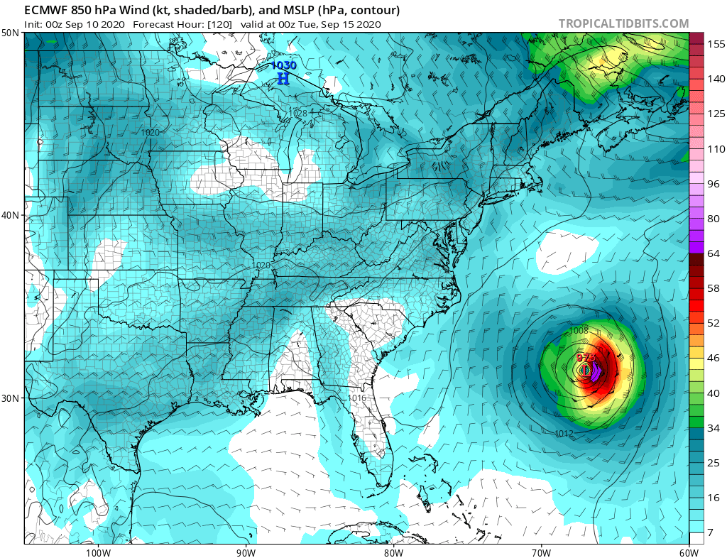
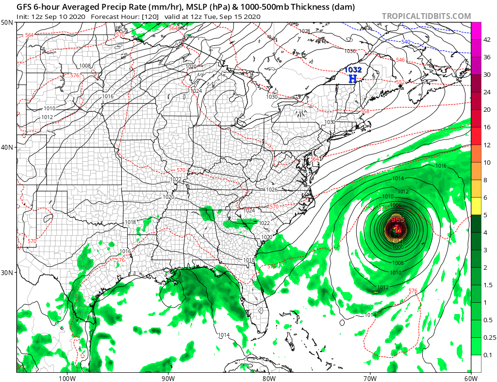
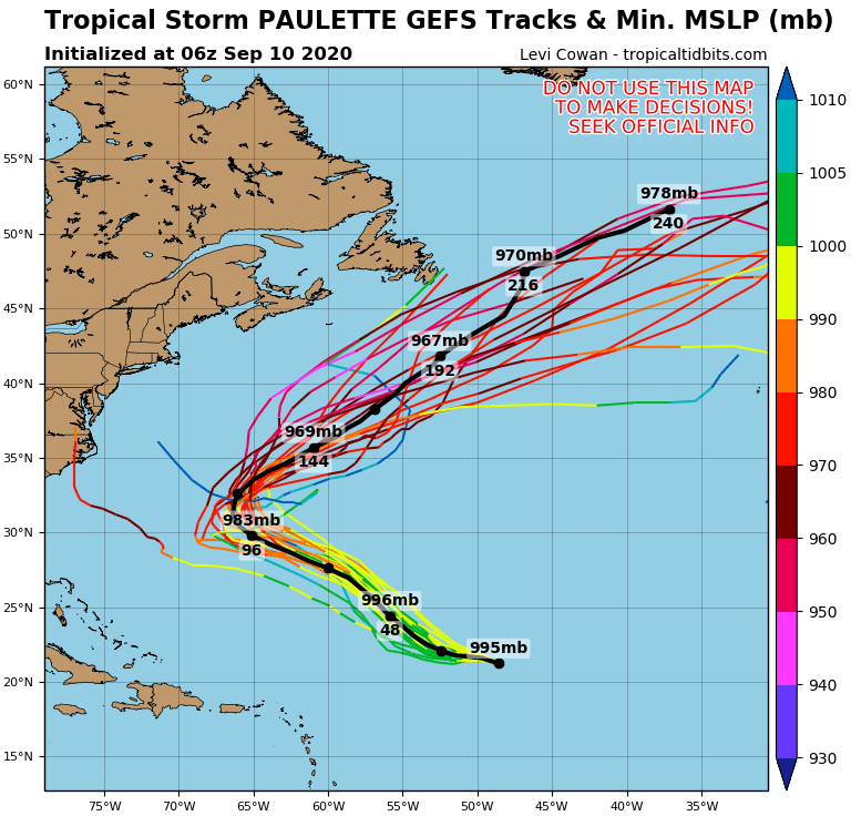
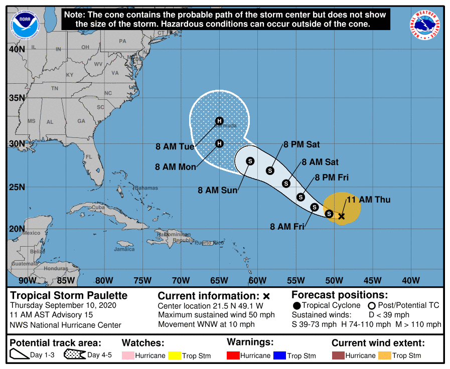
EC,GFS模式及系集對17L後期強度均頗為看好,NHC新報亦上望+120H75KT不封頂
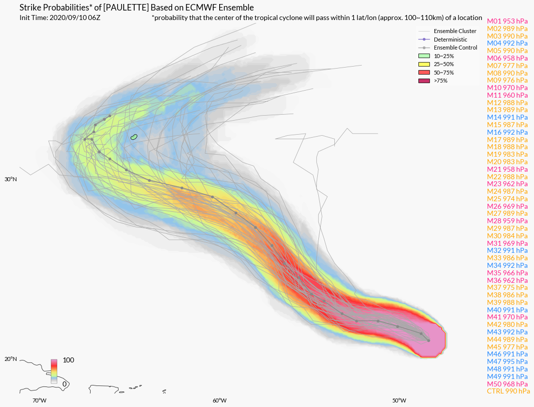
PAULETTE.png ecmwf_mslp_uv850_eus_6.png
gfs_mslp_pcpn_eus_20.png 17L_gefs_latest.png
AL172020_5day_cone_no_line_and_wind.png
000
WTNT42 KNHC 101438
TCDAT2

Tropical Storm Paulette Discussion Number  15
NWS National Hurricane Center Miami FL       AL172020
1100 AM AST Thu Sep 10 2020

The highest winds in a recent scatterometer pass have decreased a
little since last evening, and they remain embedded within deep
convection which is displaced to the north of the center of
circulation.  Paulette's intensity is estimated to have decreased
to 45 kt based on this ASCAT pass and Dvorak CI numbers of 3.0/45
kt from both TAFB and SAB.  

The sheared convection has been tugging Paulette's center northward
at times, causing wobbles in the estimated longer-term
west-northwestward motion of 295/9 kt.  For the next 4 days or so,
fluctuations in the strength of the subtropical ridge to the north
of Paulette will cause the cyclone's trajectory to vary between
west-northwest and northwest, with a peak in forward speed around
day 3.  At the end of the forecast period, a mid-latitude trough is
expected to move across the northeastern United States, with a
mid-tropospheric high becoming established over the central
Atlantic.  This should allow Paulette to begin to recurve over the
western Atlantic, turning northward by day 5.  The only notable
change in the track guidance on this cycle was a slight westward
shift among some of the models on days 4 and 5, and the NHC track
forecast follows suit, lying close to the HFIP Corrected Consensus
(HCCA) aid.

Southwesterly shear has increased over the cyclone as expected, with
the latest UW-CIMSS analysis now between 35 and 40 kt.  SHIPS
diagnoses suggest that the shear over Paulette should peak in about
12 hours, thus a little more weakening is anticipated over the next
day or so.  The shear is then forecast to gradually abate, and both
the GFS and ECMWF versions of the SHIPS guidance show the shear
magnitudes decreasing to 10 kt or less in 3-4 days.  This more
favorable environment, combined with a more unstable air mass and
sea surface temperatures exceeding 29 degrees Celsius, are expected
to allow Paulette to restrengthen and become a hurricane as it
moves in the vicinity of Bermuda.  The new NHC intensity forecast
has been raised a bit between days 2 and 4 compared to the previous
prediction, although it still lies below the intensity consensus,
IVCN, and the HCCA solutions.  Therefore, additional upward
adjustments to the forecast intensity may be required later today.


FORECAST POSITIONS AND MAX WINDS

INIT  10/1500Z 21.5N  49.1W   45 KT  50 MPH
12H  11/0000Z 21.8N  50.7W   45 KT  50 MPH
24H  11/1200Z 22.6N  52.6W   40 KT  45 MPH
36H  12/0000Z 23.8N  54.4W   40 KT  45 MPH
48H  12/1200Z 25.4N  56.3W   45 KT  50 MPH
60H  13/0000Z 26.9N  58.4W   50 KT  60 MPH
72H  13/1200Z 28.0N  61.0W   60 KT  70 MPH
96H  14/1200Z 30.0N  65.0W   70 KT  80 MPH
120H  15/1200Z 32.5N  65.0W   75 KT  85 MPH

$$
Forecaster Berg

回復

使用道具 舉報

123下一頁
快速回覆
您需要登錄後才可以回帖 登錄 | 立即加入

本版積分規則

本平台僅供學術討論之用,預報應以氣象局為準

威普網站虛擬主機贊助公司

臺灣第一個天氣類型社群平台 即時天氣資訊、精準颱風動態

線上客服
FB傳送訊息
廣告行銷
精準行銷 物超所值
官方粉專
發佈 快速回復 返回頂部 返回列表