開啟輔助訪問
 找回密碼
 立即加入

18L.Pablo 環流迷你 發展超乎預期達C1

簽到天數: 1650 天

[LV.Master]伴壇終老

2019-10-25 20:33 | 顯示全部樓層
  基本資料  
編號    :18 L
擾動編號日期:2019 10 25 19
撤編日期  :2019 10 29 19
98L INVEST 191025 1200 36.0N 33.0W ATL 30 1009
201900vesdzn453ayyyrry.jpg

  NHC:20%  

2. Shower activity has increased this morning near the center of a
large non-tropical low centered a few hundred miles southwest of
the western Azores.  Some additional development of this system is
possible during the next couple of days as it moves generally
east-northeastward.
* Formation chance through 48 hours...low...20 percent.
* Formation chance through 5 days...low...20 percent.

two_atl_2d2025.png two_atl_5d2025.png

-MAX:70,977
溫氣中心迷你颶風

評分

參與人數 1水氣能量 +15 +1 收起 理由
king111807 + 15 + 1 熱帶擾動首帖

查看全部評分

回復

使用道具 舉報

簽到天數: 3198 天

[LV.Master]伴壇終老

king111807|2019-10-26 12:40 | 顯示全部樓層
NHC提升展望至50%
2. Updated: Recent satellite derived winds indicate that the small
non-tropical low centered a few hundred miles southwest of the
western Azores is producing tropical-storm-force winds near the
center. The thunderstorm activity is becoming better organized and
if this trend continues a tropical or subtropical cyclone could form
later today. The low is forecast to move toward the east-northeast
for the next day or so and interests in the Azores should monitor
the progress of this system. For more information, see High Seas
Forecasts issued by the National Weather Service.
* Formation chance through 48 hours...medium...50 percent.
* Formation chance through 5 days...medium...50 percent.
215457cnf3u2ua32w6sazt.png
回復

使用道具 舉報

簽到天數: 3198 天

[LV.Master]伴壇終老

king111807|2019-10-26 12:45 | 顯示全部樓層
NHC展望提升至80%
1. Shower activity continues to become better organized in association
with a small-scale low pressure area embedded within a larger
extratropical low centered a few hundred miles southwest of the
Azores.  If current trends continue, advisories on a tropical or
subtropical cyclone could be initiated later today.  The low is
forecast to move toward the east-northeast, and interests in the
Azores should monitor the progress of this system.  For more
information, see High Seas Forecasts issued by Meteo France.
* Formation chance through 48 hours...high...80 percent.
* Formation chance through 5 days...high...80 percent.
024327ypnpbn7z7uz9uwxv.png
回復

使用道具 舉報

簽到天數: 3198 天

[LV.Master]伴壇終老

king111807|2019-10-26 12:57 | 顯示全部樓層
FWC-N發佈TCFA
WTNT21 KNGU 251900
SUBJ/TROPICAL CYCLONE FORMATION ALERT//
RMKS/1. FORMATION OF A SIGNIFICANT TROPICAL CYCLONE IS POSSIBLE
WITHIN 100 NM EITHER SIDE OF A LINE FROM 36.0N 33.0W TO 36.8N 30.2W
WITHIN THE NEXT 24 HOURS. AVAILABLE DATA DOES NOT JUSTIFY
ISSUANCE OF NUMBERED TROPICAL CYCLONE WARNINGS AT THIS TIME.
WINDS IN THE AREA ARE ESTIMATED TO BE 30 TO 35 KNOTS. METSAT
IMAGERY AT 251900Z INDICATES THAT A CIRCULATION CENTER IS LOCATED
NEAR 36.0N 32.7W. THE SYSTEM IS MOVING EAST-NORTHEASTWARD AT 05
KNOTS.
2. AN AREA OF LOW PRESSURE HAS FORMED A FEW HUNDRED MILES SOUTHWEST
OF THE WESTERN AZORES. ENVIRONMENTAL CONDITIONS WILL BE CONDUCIVE
FOR FURTHER DEVELOPMENT. AN INCREASE IN CONVECTIVE ORGANIZATION
COULD RESULT IN THE FORMATION OF A TROPICAL OR SUBTROPICAL
CYCLONE OVER THE NEXT 24 HOURS. THE SYSTEM IS FORECAST TO MOVE
EAST-NORTHEAST AT 05-10 KTS OVER THE NEXT SEVERAL HOURS.
3. THIS ALERT WILL BE REISSUED, UPGRADED TO WARNING OR CANCELLED
BY 261900Z.//
032447h000bcspc04cv60s.gif
回復

使用道具 舉報

簽到天數: 3279 天

[LV.Master]伴壇終老

t02436|2019-10-26 13:00 | 顯示全部樓層
昨天21Z升格18L並直接命名Pablo,36小時內轉化。
000
WTNT43 KNHC 260240
TCDAT3

Tropical Storm Pablo Discussion Number   2
NWS National Hurricane Center Miami FL       AL182019
1100 PM AST Fri Oct 25 2019

Pablo continues to exhibit a tight circulation with an occasional
eye feature evident in satellite images, which is why the system is
classified a tropical storm.  However, a larger look at the east
Atlantic reveals that Pablo is a tiny feature within a broad
extratropical cyclone.  The initial wind speed is held at 40 kt,
which is based on a recent ASCAT-C overpass that showed a small
area of tropical-storm-force winds near the center.  It should be
noted that a much larger area of winds of about the same strength,
associated with the parent extratropical low, exist to the north and
west of Pablo.

The small tropical storm is moving east-southeastward at 8 kt as
the overall trough continues to dig in that direction.  A turn to
the east should occur by early Saturday, followed by a faster
northeastward or north-northeastward motion by Saturday night,
taking the cyclone across the Azores.  By the end of the weekend and
early next week, a slower northward motion seems likely before the
storm is absorbed by another extratropical low to its west.  The NHC
track forecast lies near the middle of the guidance envelope.

Pablo could strengthen a little during the next 24 hours while it
remains in unstable conditions and over waters that should support
some convection.  However, the system is expected to move over
sharply colder waters Saturday night and Sunday, and that should
cause Pablo to lose its tropical characteristics.  The models show
the extratropical low dissipating or becoming absorbed by another
extratropical low in a little more than 3 days.

Given that Pablo is embedded within a large extratropical low,
which itself is forecast to bring strong winds to the Azores, the
Portuguese Institute for the Sea and Atmosphere (IPMA) has included
the effects of this small cyclone in their products.  Those products
already account for the strong winds and high waves expected in the
Azores.


FORECAST POSITIONS AND MAX WINDS

INIT  26/0300Z 35.5N  31.1W   40 KT  45 MPH
12H  26/1200Z 35.6N  28.9W   45 KT  50 MPH
24H  27/0000Z 37.7N  25.1W   45 KT  50 MPH
36H  27/1200Z 41.2N  22.2W   40 KT  45 MPH...POST-TROP/EXTRATROP
48H  28/0000Z 44.0N  21.1W   40 KT  45 MPH...POST-TROP/EXTRATROP
72H  29/0000Z 47.3N  20.9W   40 KT  45 MPH...POST-TROP/EXTRATROP
96H  30/0000Z...DISSIPATED

$$
Forecaster Cangialosi

024110_5day_cone_with_line.png

20191026.0430.goes-16.ircolor.18L.PABLO.40kts.990mb.35.6N.31.8W.100pc.jpg
回復

使用道具 舉報

簽到天數: 1650 天

[LV.Master]伴壇終老

老農民版夜神月|2019-10-27 17:10 | 顯示全部樓層
本帖最後由 老農民版夜神月 於 2019-10-27 17:18 編輯

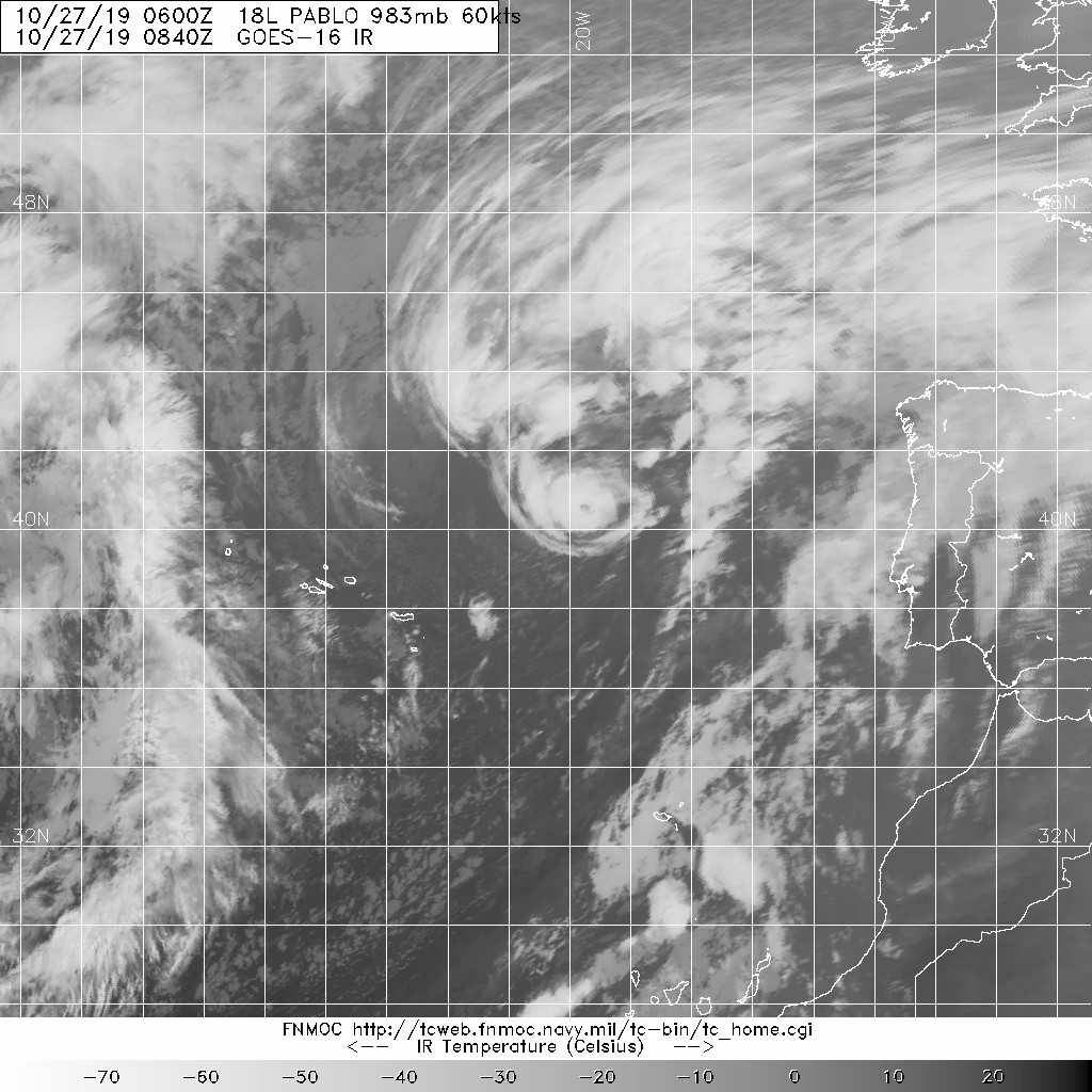
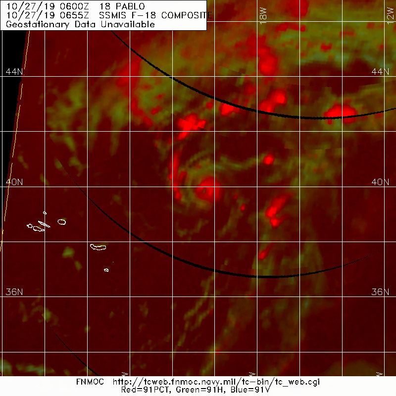
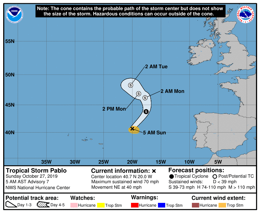
NHC27/09Z判定Pablo已達TS上限60節,並預測已達巔峰,預計12~24H後將逐漸轉化
000
WTNT43 KNHC 270832
TCDAT3

Tropical Storm Pablo Discussion Number   7
NWS National Hurricane Center Miami FL       AL182019
500 AM AST Sun Oct 27 2019

Microwave satellite imagery indicates that Pablo has maintained a
small mid-level eye feature for at least the past 18 hours, and
the eye has also been evident in infrared imagery for the past 6
hours. The most recent Dvorak satellite intensity estimate was T3.0,
which was held down due to constraints even though the eye pattern
supports an intensity of 65 kt. Latest UW-CIMSS objective ADT and
SATCON intensity estimates are T4.4/75 kt and 64 kt, respectively.
Based on a blend of the TAFB and UW-CIMSS values, along with the
5- to 8-nmi-diameter eye, the intensity has been increased to 60 kt,
which could be conservative due to the the cyclone's relatively fast
forward speed.

Pablo has continued to accelerate and the initial motion estimate is
now 045/35 kt. The latest model guidance remains in good agreement
that during the next 48 hours, Pablo should slow down while making a
counter-clockwise track around the northeastern periphery of the
larger extratropical low that the small cyclone is embedded within.
The tightly packed guidance suite has shifted to the right of the
previous advisory track, and the new NHC forecast track has been
adjusted in that direction, close to the various consensus models.

Pablo is currently located over 20 deg C sea-surface temperatures
(SST), with colder water near 15 deg C ahead of the cyclone. Model
forecast soundings indicate that mid- and upper-level temperatures
will be warming, and when combined with the cooler SSTs, will result
in stabilization of the troposphere. This will cause convection to
steadily weaken and erode by 12 h, resulting in Pablo degenerating
into a post-tropical extratropical low pressure system in 24 h, if
not sooner. The small cyclone is forecast to dissipate or become
absorbed by the larger parent extratropical low in the 48-72 h
forecast period.


FORECAST POSITIONS AND MAX WINDS

INIT  27/0900Z 40.7N  20.0W   60 KT  70 MPH
12H  27/1800Z 43.8N  17.6W   55 KT  65 MPH
24H  28/0600Z 46.2N  17.8W   50 KT  60 MPH...POST-TROP/EXTRATROP
36H  28/1800Z 46.9N  18.9W   45 KT  50 MPH...POST-TROP/EXTRATROP
48H  29/0600Z 48.3N  20.3W   40 KT  45 MPH...POST-TROP/EXTRATROP
72H  30/0600Z...DISSIPATED

$$
Forecaster Stewart
083425_5day_cone_no_line_and_wind.png 19072.jpg
cfb8f01f3a292df560b03765b3315c6034a87321.jpg


回復

使用道具 舉報

簽到天數: 1650 天

[LV.Master]伴壇終老

老農民版夜神月|2019-10-27 23:20 | 顯示全部樓層
NHC27/15Z判定升格為一級颶風
056
WTNT43 KNHC 271450
TCDAT3

Hurricane Pablo Discussion Number   8
NWS National Hurricane Center Miami FL       AL182019
1100 AM AST Sun Oct 27 2019

Satellite imagery shows that Pablo has continued to maintain a
small eye, and that the eyewall cloud tops have recently cooled.
In addition, early morning microwave satellite intensity estimates,
as well as the CIMSS satellite consensus, indicate that Pablo has
become a hurricane.  The initial intensity is increased to 65 kt as
a blend between the subjective estimate from TAFB and the higher
SATCON estimate, and it is possible this is a little conservative.
The intensification has occurred while Pablo is over sea surface
temperatures of 19-20C, and it is likely that cold mid- to
upper-level air temperatures have allowed the cyclone to maintain
deep convection and strengthen over water temperatures where
tropical cyclones normally weaken.

The initial motion is now 030/28.  The cyclone is expected to turn
northward and slow its forward motion as it approaches a frontal
system to the north during the next 12-24 h, and this will be
followed by a turn toward the northwest as a large mid-latitude low
over the north central Atlantic becomes the main steering mechanism.
The track guidance has again shifted a little to the east, and the
new forecast track is also nudged a little to the east of the
previous track.  Like the previous forecast, it lies close to the
various consensus models.

Pablo should encounter even colder water along the forecast track,
and global model guidance suggests it should merge with the frontal
system between 12-24 h.  This combination should cause Pablo to
weaken and become an extratropical cyclone.  Thereafter, the system
should be absorbed by the much larger low to its west between 48-72
h.


FORECAST POSITIONS AND MAX WINDS

INIT  27/1500Z 42.8N  18.3W   65 KT  75 MPH
12H  28/0000Z 45.3N  17.2W   55 KT  65 MPH
24H  28/1200Z 46.9N  17.8W   50 KT  60 MPH...POST-TROP/EXTRATROP
36H  29/0000Z 47.9N  18.7W   45 KT  50 MPH...POST-TROP/EXTRATROP
48H  29/1200Z 49.5N  20.3W   40 KT  45 MPH...POST-TROP/EXTRATROP
72H  30/1200Z...DISSIPATED

$$
Forecaster Beven
145154_5day_cone_no_line_and_wind.png 2019AL18_1KMVSIMG_201910261114.gif
2019AL18_4KMIRIMG_201910271430.gif


回復

使用道具 舉報

簽到天數: 1650 天

[LV.Master]伴壇終老

老農民版夜神月|2019-10-29 00:13 | 顯示全部樓層
NHC28/15Z判定轉溫,並發出最終報
000
WTNT43 KNHC 281440
TCDAT3

Post-Tropical Cyclone Pablo Discussion Number  12
NWS National Hurricane Center Miami FL       AL182019
1100 AM AST Mon Oct 28 2019

Cold waters of 16C and increasing shear caused the deep convection
near Pablo's center to dissipate early this morning, and the
cyclone now consists of a swirl of low- to mid-level clouds and
showers. This lack of deep convection has caused Pablo to now
become post-tropical. A recent ASCAT pass showed an area of 30 to
35 kt winds northwest of the center of Pablo, and the initial
intensity is set to 35 kt based on those data. In addition, the
scatterometer data showed a much larger area of gale-force
winds well to the north of, but not directly associated with
Pablo.

The post-tropical cyclone will move slowly north to northwest over
the next day or so, until it is absorbed by a much larger
mid-latitude low to its west. The gales occurring north of the
Pablo are expected to persist at least until it is absorbed.

Additional information on this system can be found in:

High Seas Forecasts issued by Meteo France under WMO header FQNT50
LFPW and on the web at
www.meteofrance.com/previsions-meteo-marine/bulletin/grandlarge/
metarea2.

High Seas Forecasts issued by the UK Met Office under WMO header
FQNT21 EGRR and on the web at
metoffice.gov.uk/weather/specialist-forecasts/coast-and-sea/high-
seas-forecast/.

FORECAST POSITIONS AND MAX WINDS

INIT  28/1500Z 46.8N  17.7W   35 KT  40 MPH...POST-TROPICAL
12H  29/0000Z 47.4N  17.9W   35 KT  40 MPH...POST-TROP/EXTRATROP
24H  29/1200Z 48.5N  18.3W   35 KT  40 MPH...POST-TROP/EXTRATROP
36H  30/0000Z...DISSIPATED

$$
Forecaster Latto
144135_5day_cone_no_line_and_wind.png 19232.jpg


回復

使用道具 舉報

快速回覆
您需要登錄後才可以回帖 登錄 | 立即加入

本版積分規則

本平台僅供學術討論之用,預報應以氣象局為準

威普網站虛擬主機贊助公司

臺灣第一個天氣類型社群平台 即時天氣資訊、精準颱風動態

線上客服
FB傳送訊息
廣告行銷
精準行銷 物超所值
官方粉專
發佈 快速回復 返回頂部 返回列表