開啟輔助訪問
 找回密碼
 立即加入

11E.Juliette 巔峰掠過墨國克拉里翁島

簽到天數: 2414 天

[LV.Master]伴壇終老

2019-8-31 15:40 | 顯示全部樓層
  基本資料  
編號    :11 E
擾動編號日期:2019 08 31 15
撤編日期  :2019 09 00 00
98E.INVEST.25kts-1009mb-10.2N-104.8W

20190831.0600.goes16.x.ir1km_bw.98EINVEST.25kts-1009mb-102N-1048W.100pc.jpg

  NHC:30%  
1. A broad area of low pressure located several hundred miles south-
southwest of the southern coast of Mexico is producing a large area
of disorganized showers and thunderstorms.  Environmental conditions
appear conducive for development of this system, and a tropical
depression is likely to form next week while the system moves
west-northwestward at 10 to 15 mph.
* Formation chance through 48 hours...low...30 percent.
* Formation chance through 5 days...high...70 percent. two_pac_2d1.png


--max:110kt 953hPa

評分

參與人數 1水氣能量 +15 +1 收起 理由
t02436 + 15 + 1

查看全部評分

回復

使用道具 舉報

簽到天數: 1650 天

[LV.Master]伴壇終老

老農民版夜神月|2019-9-1 04:14 | 顯示全部樓層
NHC展望迅速提升至High,70%/90%
1. Showers and thunderstorms associated with a broad area of low
pressure located several hundred miles south-southwest of the
southern coast of Mexico have become better organized since
yesterday.   Environmental conditions appear conducive for further
development of this system, and a tropical depression is expected to
form during the next 2 or 3 days while the system moves west-
northwestward at 10 to 15 mph.
* Formation chance through 48 hours...high...70 percent.
* Formation chance through 5 days...high...90 percent.

two_pac_2d0831.png two_pac_2d1831.png
two_pac_5d1831.png
JTWC亦於31/1430Z發布TCFA
WTPN21 PHNC 311430
MSGID/GENADMIN/JOINT TYPHOON WRNCEN PEARL HARBOR HI//
SUBJ/TROPICAL CYCLONE FORMATION ALERT (INVEST 98E)//
RMKS/
1. FORMATION OF A SIGNIFICANT TROPICAL CYCLONE IS POSSIBLE WITHIN
160 NM EITHER SIDE OF A LINE FROM 11.1N 105.2W TO 14.7N 110.8W
WITHIN THE NEXT 12 TO 24 HOURS. AVAILABLE DATA DOES NOT JUSTIFY
ISSUANCE OF NUMBERED TROPICAL CYCLONE WARNINGS AT THIS TIME.
WINDS IN THE AREA ARE ESTIMATED TO BE 23 TO 28 KNOTS. METSAT
IMAGERY AT 311200Z INDICATES THAT A CIRCULATION CENTER IS LOCATED
NEAR 11.3N 105.5W. THE SYSTEM IS MOVING NORTHWESTWARD AT 08
KNOTS.
2. REMARKS:
HE AREA OF CONVECTION (INVEST 98E) LOCATED NEAR 11.3N 105.5W,
APPROXIMATELY 542 NM SOUTHEAST OF SOCORRO. ANIMATED ENHANCED
INFRARED SATELLITE IMAGERY, ALOND WITH A 311218Z SSMIS F-18 91GHZ
MICROWAVE IMAGE, DEPICTS BUILDING DEEP CONVECTION OVERHEAD THE LOW
LEVEL CIRCULATION CENTER WITH FORMATIVE BANDING WRAPPING IN FROM THE
NORTH AND SOUTH. 98E IS CURRENTLY IN A FAVORABLE ENVIRONMENT WITH
VERY GOOD UPPER LEVEL OUTFLOW, LOW (15 TO 20 KNOT) VERTICAL WIND
SHEAR, AND WARM (28 TO 29 CELSIUS) SEA SURFACE TEMPERATURES. GLOBAL
MODELS ARE IN VERY GOOD AGREEMENT THAT 98E WILL TRACK NORTHWESTWARD
AND INTENSIFY WITHIN THE NEXT TWO DAYS. MAXIMUM SUSTAINED SURFACE
WINDS ARE ESTIMATED AT 23 TO 28 KNOTS. MINIMUM SEA LEVEL PRESSURE IS
ESTIMATED TO BE NEAR 1001 MB. THE POTENTIAL FOR THE DEVELOPMENT OF A
SIGNIFICANT TROPICAL CYCLONE WITHIN THE NEXT 24 HOURS IS HIGH.
3. THIS ALERT WILL BE REISSUED, UPGRADED TO WARNING OR CANCELLED BY
011430Z.//
NNNN

ep9819.gif 98E_311200sair.jpg

回復

使用道具 舉報

簽到天數: 1650 天

[LV.Master]伴壇終老

老農民版夜神月|2019-9-1 16:48 | 顯示全部樓層
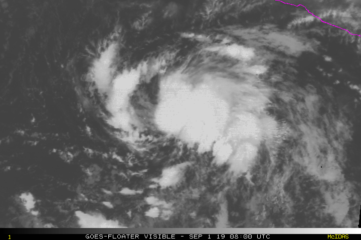
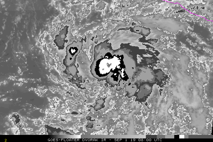
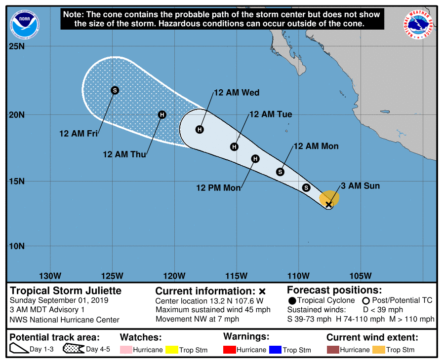
NHC01/09Z報中直接升格11E為TS,命名Juliette,首報巔峰上望75節
WTPZ41 KNHC 010832
TCDEP1

Tropical Storm Juliette Discussion Number   1
NWS National Hurricane Center Miami FL       EP112019
300 AM MDT Sun Sep 01 2019

Earlier scatterometer surface wind data around 0400 UTC indicate
that the low pressure system located about 400 nmi south-southwest
of Manzanillo, Mexico, had become better defined and that
tropical-storm-force winds were occurring in the northern
semicircle. More specifically, an ASCAT-A pass revealed peak surface
winds of 42 kt, which could have been slightly rain inflated, and an
ASCAT-C pass showed peak winds of 39 kt. Based on a blend of
these wind data, the low has been upgraded to a 40-kt tropical
storm, the tenth tropical storm of the 2019 eastern North Pacific
hurricane season.

Juliette's initial motion estimate is an uncertain 310/06 kt. The
advisory position is an average of the locations of the mid- and
low-level circulation centers, in anticipation of the low-level
center noted in the ASCAT-C wind data developing closer to the
recent bursts of central deep convection. Otherwise, the track
forecast is pretty straight-forward with the NHC model guidance in
good agreement on maintaining the deep-layer ridge to the north of
Juliette throughout the forecast period. This steering pattern
should result in the cyclone moving slowly northwestward today,
followed by a turn toward the west-northwest with an increase in
forward speed on Monday, with a west-northwestward motion continuing
through 120 hours. The NHC forecast track lies close to the tightly
packed consensus models HCCA and TVCE.

Juliette is expected to remain within a favorable environment for
intensification to occur over the next 48-72 hours or so, which is
characterized by low vertical wind shear of less than 10 kt, a
moist mid-level environment, and sea-surface temperatures (SST) of
28-29 deg C. Therefore, the official intensity forecast calls for
steady strengthening, with Juliette expected to become a hurricane
on Monday. By 96 hours, the cyclone will be moving over SSTs around
26 deg C and cooler, which should induce gradual weakening. The NHC
intensity forecast is above the consensus intensity models HCCA and
IVCN, and is close to a blend of the statistical SHIPS intensity
models and the dynamical HWRF model.

FORECAST POSITIONS AND MAX WINDS

INIT  01/0900Z 13.2N 107.6W   40 KT  45 MPH
12H  01/1800Z 14.5N 109.4W   45 KT  50 MPH
24H  02/0600Z 15.7N 111.5W   55 KT  65 MPH
36H  02/1800Z 16.7N 113.5W   65 KT  75 MPH
48H  03/0600Z 17.6N 115.2W   75 KT  85 MPH
72H  04/0600Z 18.9N 118.0W   75 KT  85 MPH
96H  05/0600Z 20.0N 121.0W   70 KT  80 MPH
120H  06/0600Z 21.8N 124.8W   55 KT  65 MPH

$$
Forecaster Stewart
083340_5day_cone_no_line_and_wind.png vis0901.gif
bd0.gif

回復

使用道具 舉報

簽到天數: 601 天

[LV.9]以壇為家II

霧峰追風者|2019-9-3 14:01 | 顯示全部樓層
強度升三級颶風,巔峰上望C4。
000
WTPZ41 KNHC 030233
TCDEP1

Hurricane Juliette Discussion Number   8
NWS National Hurricane Center Miami FL       EP112019
900 PM MDT Mon Sep 02 2019

Enhanced BD-curve infrared GOES-17 imagery shows that Juliette is
undergoing a rapid intensification evolution.  An earlier GMI
microwave pass revealed that the eyewall has completed closed off,
and this is also visible in the infrared images as a -70C black
ring. A blend of the subjective and objective satellite intensity
estimates yield 80 kt, but since that time, due to the much improved
inner core now depicted in imagery, the initial intensity is raised
to 100 kt.

Rapid strengthening should continue during the next 12 hours or so.
Beyond the short term intensification trend, Juliette is forecast to
continue to move within a favorable atmosphere consisting of low
deep-layer shear, a diffluent upper wind pattern, and warm oceanic
temperatures which should allow Juliette to strengthen a bit
further.  Afterward, a steady weakening trend is forecast as
Juliette traverses cooler water and moves into a more stable, drier
marine layer air mass.

Juliette's initial motion is estimated to be northwestward, or
310/9 kt. The cyclone should continue moving generally
northwestward, or west-northwestward within the mid-tropospheric
steering flow produced by a subtropical ridge to the north of
Juliette, and an upper-level low just to the west-southwest.
There's still quite a bit of across-track model spread beyond the 48
hour period in response to continued large-scale synoptic
dissimilarities in the strength of the subtropical ridge.  The NHC
track forecast is similar to the previous one, and is close to the
TVCE consensus model.

FORECAST POSITIONS AND MAX WINDS

INIT  03/0300Z 17.8N 114.0W  100 KT 115 MPH
12H  03/1200Z 18.4N 115.1W  115 KT 130 MPH
24H  04/0000Z 18.9N 116.4W  115 KT 130 MPH
36H  04/1200Z 19.4N 117.8W  100 KT 115 MPH
48H  05/0000Z 19.9N 119.4W   85 KT 100 MPH
72H  06/0000Z 21.4N 123.2W   65 KT  75 MPH
96H  07/0000Z 23.0N 127.8W   45 KT  50 MPH
120H  08/0000Z 24.1N 131.3W   35 KT  40 MPH

$$
Forecaster Roberts
023605_5day_cone_no_line_and_wind.png goes16_ir_11E_201909030545.jpg
回復

使用道具 舉報

簽到天數: 601 天

[LV.9]以壇為家II

霧峰追風者|2019-9-5 09:17 | 顯示全部樓層
巔峰已過,逐漸減弱。
000
WTPZ41 KNHC 042038
TCDEP1

Hurricane Juliette Discussion Number  15
NWS National Hurricane Center Miami FL       EP112019
200 PM PDT Wed Sep 04 2019

Juliette continues to exhibit a large, ragged eye in both visible
and infrared satellite imagery, but there are some breaks in the
convective banding.  Warming of the cloud tops over the southeastern
portion of the circulation has also been observed.  Recent microwave
data show that the low-level eye remains fairly well defined, and
that the center was located a little south of the previous
estimates.  The initial intensity remains 85 kt, which is a blend of
the various objective and subjective satellite intensity estimates.
Although the vertical shear is forecast to remain quite low during
the next several days, the hurricane will be moving over decreasing
SSTs and into less favorable thermodynamic conditions.  This should
result in gradual weakening during the next several days, and
Juliette is now forecast to become a remnant low by the end of the
forecast period.

The hurricane is moving west-northwestward or 295/6 kt.  A mid-level
ridge extending from the southwestern United States over the eastern
Pacific should continue to steer Juliette west- northwestward at a
slightly faster forward speed during the next 2 to 3 days.  After
that time, the cyclone is predicted to turn westward as it weakens
and is steered by the easterly trade wind flow.  The farther south
initial position required a slight southward adjustment of the early
portion of the track forecast, but the latter portion remains
similar to the previous official forecast.  The track guidance is
tightly clustered and the NHC forecast is near middle of the
envelope.

The wind radii were adjusted slightly based on recent scatterometer
data.


FORECAST POSITIONS AND MAX WINDS

INIT  04/2100Z 19.4N 117.8W   85 KT 100 MPH
12H  05/0600Z 20.0N 118.9W   75 KT  85 MPH
24H  05/1800Z 21.1N 120.5W   70 KT  80 MPH
36H  06/0600Z 22.1N 122.4W   60 KT  70 MPH
48H  06/1800Z 23.0N 124.4W   50 KT  60 MPH
72H  07/1800Z 23.6N 128.1W   35 KT  40 MPH
96H  08/1800Z 23.2N 131.5W   30 KT  35 MPH
120H  09/1800Z 22.8N 135.5W   30 KT  35 MPH...POST-TROP/REMNT LOW

$$
Forecaster Brown
203941_5day_cone_no_line_and_wind.png goes16_ir_11E_201909050045.jpg
回復

使用道具 舉報

簽到天數: 582 天

[LV.9]以壇為家II

蜜露|2019-9-7 21:17 | 顯示全部樓層


20190903.1130.goes15.x.ir1km_bw.11EJULIETTE.100kts-963mb-180N-1142W.100pc.jpg

a888b48f8c5494eec294c33b22f5e0fe99257e30.jpg


茱麗葉颶風巔峰經過了墨西哥克拉里翁島,實測海壓是958.1hPa


巔峰約955hPa  可能只是一個Cat.3的颶風而已,她是眼牆掃過島的,之後逐漸減弱。


回復

使用道具 舉報

快速回覆
您需要登錄後才可以回帖 登錄 | 立即加入

本版積分規則

0908morakot

    主題

    帖子

    69萬

    積分

    12級[颶風Hurricane]

    Rank: 12Rank: 12Rank: 12

12級[颶風Hurricane]

發訊息

本平台僅供學術討論之用,預報應以氣象局為準

威普網站虛擬主機贊助公司

臺灣第一個天氣類型社群平台 即時天氣資訊、精準颱風動態

線上客服
FB傳送訊息
廣告行銷
精準行銷 物超所值
官方粉專
發佈 快速回復 返回頂部 返回列表