開啟輔助訪問
 找回密碼
 立即加入

19E 短暫發展 於加利福尼亞灣突然升格

簽到天數: 2414 天

[LV.Master]伴壇終老

2018-9-18 21:24 | 顯示全部樓層
  基本資料  
編號    :19 E
擾動編號日期:2018 09 18 21
撤編日期  :2018 09 20 18
94E.INVEST.25kts.1008mb.22.6N.109.6W

20180918.1300.goes-15.ir.94E.INVEST.25kts.1008mb.22.6N.109.6W.100pc.jpg

  NHC:50%  
1. A broad and elongated area of low pressure extending from near the
southern tip of the Baja California peninsula southwestward for a
few hundred miles continues to produce widespread but disorganized
showers and thunderstorms.  Although environmental conditions appear
conducive for tropical cyclone formation, the large size of the
system and land interaction is expected to limit the development
potential of this disturbance.  However, this system could still
become a tropical depression during the next day or two while it
moves near Baja California Sur and the Gulf of California.
Regardless of development, this disturbance will likely produce very
heavy rainfall over Baja California Sur and other parts of
northwestern mainland Mexico over the next several days. Interests
in Baja California Sur and northwestern Mexico should monitor the
progress of this disturbance.
* Formation chance through 48 hours...medium...40 percent.
* Formation chance through 5 days...medium...40 percent.

two_pac_2d1.png

評分

參與人數 1水氣能量 +15 +1 收起 理由
king111807 + 15 + 1 熱帶擾動首帖

查看全部評分

回復

使用道具 舉報

簽到天數: 2088 天

[LV.Master]伴壇終老

周子堯@FB|2018-9-19 20:34 | 顯示全部樓層
貼近陸地,NHC評級降至Low
1. A large area of disorganized showers and thunderstorms extending
from the southern Baja California peninsula northeastward over the
southern and central portions of the Gulf of California are
associated with a broad area of low pressure.  Although the
thunderstorm activity has increased and become more concentrated
this morning, the system is forecast to move northward into
northwestern mainland Mexico tonight limiting its development
potential.  Regardless of development, this disturbance is
expected to produce total rain accumulations of 5 to 10 inches,
with isolated maximum amounts of 15 inches across portions of Baja
California Sur, Sinaloa, and Sonora through Thursday. This rainfall
may cause life-threatening flash floods and mudslides. Moisture
from this disturbance will also lead to areas of heavy rainfall and
a risk of flash flooding in the southwestern United States
beginning today.
* Formation chance through 48 hours...low...30 percent.
* Formation chance through 5 days...low...30 percent.
two_pac_2d1.png
20180919.1130.goes-15.ir.94E.INVEST.25kts.1008mb.23.2N.110.4W.100pc.jpg


回復

使用道具 舉報

簽到天數: 601 天

[LV.9]以壇為家II

霧峰追風者|2018-9-19 23:59 | 顯示全部樓層
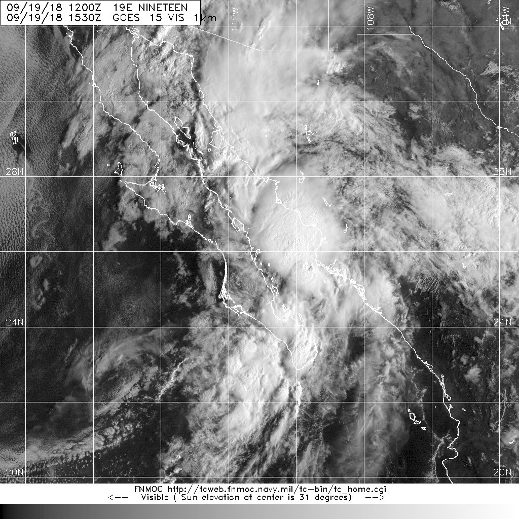
21Z在下加利福尼亞灣,突然升格熱帶低壓19E,風速只有25節,即將登陸墨西哥西岸。
365
WTPZ44 KNHC 191455
TCDEP4

Tropical Depression Nineteen-E Discussion Number   1
NWS National Hurricane Center Miami FL       EP192018
Issued by the NWS Weather Prediction Center College Park MD
900 AM MDT Wed Sep 19 2018

Satellite images show that an area of low pressure has developed
over the Gulf of California overnight within an inverted trough.
This is also supported by 24-hour pressure falls of 3.7 mb at Loreto
just west of its center at 1300 UTC. Microwave imagery shows
curved convective banding features to the east and north of the
center, suggesting organized convection. Therefore the system
is being declared a tropical depression with 25-kt maximum sustained
winds. Infrared imagery shows minimal vertical wind shear over the
system, with a slight restriction to the outflow on its western
side, which is confirmed by recent SHIPS output.  However, the
system has only 12 hours or less over water, and it is expected to
move inland without significant strengthening.

An upper-level trough moving into the western United States is
expected to steer the depression north or north-northeast across the
Gulf of California into northwest Mexico tonight, which is well
advertised by the track guidance.  The depression is expected to
dissipate in the 24-36 hour time frame due to steep terrain.

The main impact with the system is expected to be heavy rainfall,
with 5-10 inch areal average amounts and local amounts to 15 inches
leading to life-threatening flash flooding and landslides near the
track of the depression.


FORECAST POSITIONS AND MAX WINDS

INIT  19/1500Z 26.3N 110.9W   25 KT  30 MPH
12H  20/0000Z 28.0N 110.7W   25 KT  30 MPH...INLAND
24H  20/1200Z 30.5N 109.5W   15 KT  15 MPH...POST-TROP/REMNT LOW
36H  21/0000Z...DISSIPATED

$$
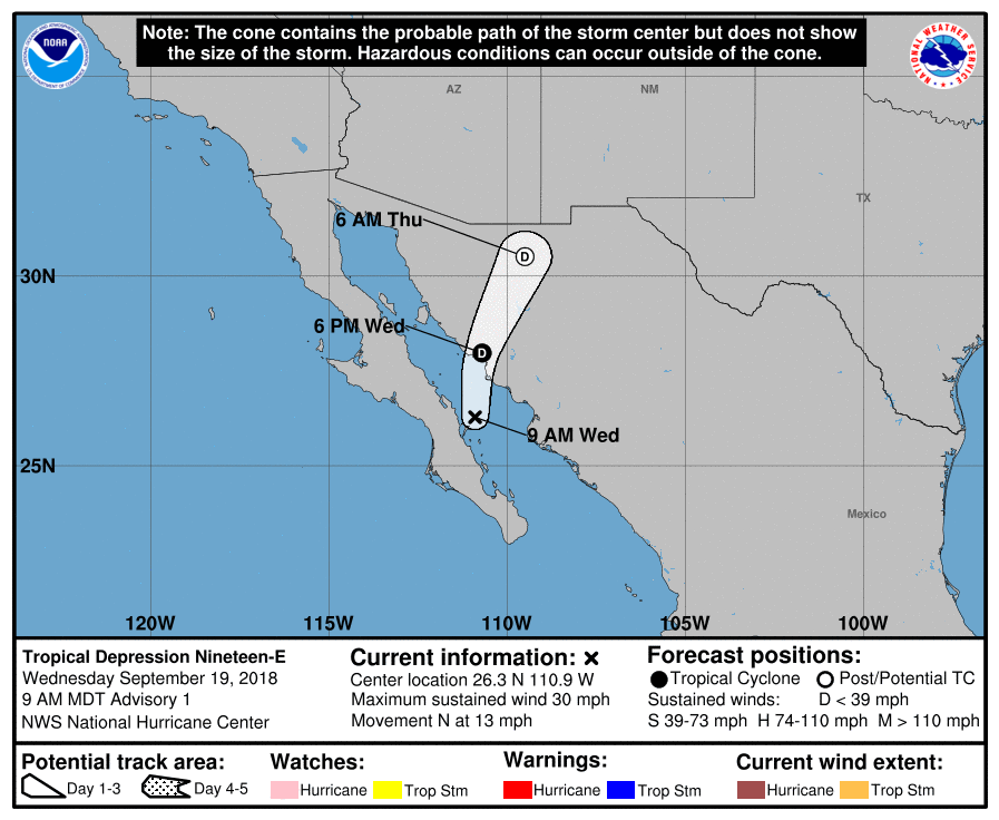
145644_5day_cone_no_line_and_wind.png 20180919.1530.goes-15.vis.1km.19E.NINETEEN.25kts.1004mb.25.8N.111.1W.100pc.jpg

回復

使用道具 舉報

簽到天數: 2088 天

[LV.Master]伴壇終老

周子堯@FB|2018-9-20 20:15 | 顯示全部樓層
登陸後,NHC發出19E最後一報,NRL也隨即將其撤編,結束短暫的一生
575
FZPN03 KNHC 200832
HSFEP2

HIGH SEAS FORECAST
NWS NATIONAL HURRICANE CENTER MIAMI FL
1030 UTC THU SEP 20 2018

SUPERSEDED BY NEXT ISSUANCE IN 6 HOURS

SEAS GIVEN AS SIGNIFICANT WAVE HEIGHT...WHICH IS THE AVERAGE
HEIGHT OF THE HIGHEST 1/3 OF THE WAVES. INDIVIDUAL WAVES MAY BE
MORE THAN TWICE THE SIGNIFICANT WAVE HEIGHT.

SECURITE

E PACIFIC FROM THE EQUATOR TO 30N E OF 140W AND 03.4S TO THE
EQUATOR E OF 120W

SYNOPSIS VALID 0600 UTC THU SEP 20.
24 HOUR FORECAST VALID 0600 UTC FRI SEP 21.
48 HOUR FORECAST VALID 0600 UTC SAT SEP 22.

.WARNINGS.

.NONE.

.SYNOPSIS AND FORECAST.

.REMNANTS OF NINETEEN-E OVER LAND NEAR 28.1N 110.0W 1003 MB AT
0900 UTC SEP 20 MOVING NNE OR 020 DEG AT 8 KT. MAXIMUM SUSTAINED
WINDS 20 KT GUSTS 30 KT. GULF OF CALIFORNIA BETWEEN 24N AND 26N
SW WINDS 20 TO 25 KT. SEAS TO 8 FT.
.12 HOUR FORECAST TROPICAL DEPRESSION NINETEEN-E OVER LAND NEAR
28.5N 109.8W. MAXIMUM SUSTAINED WINDS 20 KT GUSTS 30 KT. OVER
FORECAST WATERS WINDS 20 KT OR LESS. SEAS LESS THAN 8 FT.
.24 HOUR FORECAST...DISSIPATED.

.N OF 28N BETWEEN 120W AND 128W WINDS 20 KT OR LESS. SEAS 8 TO 9
FT IN NW TO N SWELL.
.24 HOUR FORECAST N OF 28N BETWEEN 124W AND 128W WINDS 20 KT OR
LESS. SEAS 8 FT IN N SWELL.
.48 HOUR FORECAST WINDS 20 KT OR LESS. SEAS LESS THAN 8 FT.

.FROM 14N TO 19N W OF 130W WINDS 20 KT OR LESS. SEAS TO 8 FT IN
NE SWELL.
.24 HOUR FORECAST WINDS 20 KT OR LESS. SEAS LESS THAN 8 FT.

.REMAINDER OF AREA WINDS 20 KT OR LESS. SEAS LESS THAN 8 FT.

CONVECTION VALID AT 0830 UTC THU SEP 20...

.INTERTROPICAL CONVERGENCE ZONE/MONSOON TROUGH...
MONSOON TROUGH FROM 09N79W TO 12N110W...RESUMES FROM LOW PRES
NEAR 17N119W TO 13N125W TO 12N140W. SCATTERED MODERATE FROM 07N
TO 10N BETWEEN 108W AND 117W...AND WITHIN 30 NM OF AXIS BETWEEN
122W AND 130W.

$$
.FORECASTER MUNDELL. NATIONAL HURRICANE CENTER.

083310_5day_cone_no_line_and_wind.png
20180920.1030.goes-15.ir.19E.NINETEEN.25kts.1003mb.27.8N.110.3W.100pc.jpg


回復

使用道具 舉報

快速回覆
您需要登錄後才可以回帖 登錄 | 立即加入

本版積分規則

本平台僅供學術討論之用,預報應以氣象局為準

威普網站虛擬主機贊助公司

臺灣第一個天氣類型社群平台 即時天氣資訊、精準颱風動態

線上客服
FB傳送訊息
廣告行銷
精準行銷 物超所值
官方粉專
發佈 快速回復 返回頂部 返回列表