開啟輔助訪問
 找回密碼
 立即加入

12L.Jose 結束海上漂泊生涯

簽到天數: 3291 天

[LV.Master]伴壇終老

t02436|2017-9-8 22:19 | 顯示全部樓層
不得了了!
第一次飛機實測已經啟動,穿心完第一次直接在14Z加發特報調升強度到130節!!
等等馬上進行第二次穿心。
ZCZC MIATCUAT2 ALL
TTAA00 KNHC DDHHMM

Hurricane Jose Tropical Cyclone Update
NWS National Hurricane Center Miami FL       AL122017
1000 AM AST Fri Sep 08 2017

...HURRICANE HUNTER PLANE FINDS JOSE IS A CATEGORY 4 HURRICANE...

Data from an Air Force Hurricane Hunter plane indicate that the
maximum sustained winds in Jose have increased to near 150 mph (240
km/h), making Jose an extremely dangerous category 4 hurricane.
This intensity change will be reflected in the upcoming 1100 AM
AST (1500 UTC) advisory.


SUMMARY OF 1000 AM AST...1400 UTC...INFORMATION
----------------------------------------------
LOCATION...16.2N 56.9W
ABOUT 435 MI...700 KM ESE OF THE NORTHERN LEEWARD ISLANDS
MAXIMUM SUSTAINED WINDS...150 MPH...240 KM/H
PRESENT MOVEMENT...WNW OR 285 DEGREES AT 18 MPH...30 KM/H
MINIMUM CENTRAL PRESSURE...942 MB...27.82 INCHES

$$
Forecaster Zelinsky


NNNN

recon_AF305-0112A-JOSE.png

recon_AF305-0112A-JOSE_timeseries.png

20170908.1345.goes-13.irbd.12L.JOSE.110kts.942mb.16.1N.56.4W.100pc.jpg

rbtop-animated.gif
回復

使用道具 舉報

簽到天數: 969 天

[LV.10]以壇為家III

kbty245|2017-9-9 02:39 | 顯示全部樓層
當大家都在關注Irma

Jose正悄悄的上演華麗的變身秀


飛機在短短的兩次穿心內

氣壓就下降了4mb

recon_AF305-0112A-JOSE.png


驚人的是海平面最大風速

居然高達146kts、149kts

如果沒意外NHC會升格Jose為Cat.5

如果Irma也重新增強為Cat.5

將會是罕見的雙Cat.5等級的颶風共舞
recon_AF305-0112A-JOSE_timeseries.png


20170908.1745.goes13.x.ir1km.12LJOSE.130kts-942mb-161N-564W.100pc.jpg


當然

從色調強化上來看

Jose不過是個連W環都不合格的普通颶風

雖然有著+16度的WMG眼

但用德渥夏克分析法

B+WMG不過T 6.0而已

對應起來不過就是115kts的"普通"Cat.4

和實測有一段差距

但看過底層掃苗、可見光雲圖後

就可略知一二

20170908.1551.gpm.x.89h.12LJOSE.130kts-942mb-161N-564W.31pc.jpg


底層非常扎實,190強度的地方幾乎是成環的

這是頂級熱帶氣旋才會有的底層


20170908.1745.goes13.x.vis1km_high.12LJOSE.130kts-942mb-161N-564W.100pc.jpg


可見光來看

CDO非常平滑且圓潤

同樣是頂級颱風才會有的CDO

從北面環流那長長的6字尾巴

和大量的針狀雲

也可得知這個風暴正處於極向流出非常強烈的地區

事實也是Jose受惠於槽潛幅散

才得以爆發

但這些都是用德法看不出來的

或許是時候修正一下德法了

尤其是增加底層判斷的部分

從Irma到Jose

都顯示出比起雲頂溫度

底層的樣貌才是展現出風暴實力的真正所在


點評

荷西颶風目前仍舊只給130KTS,但不排除NHC會在事後往上修正至140KTS的強度。  發表於 2017-9-9 10:00
回復

使用道具 舉報

簽到天數: 588 天

[LV.9]以壇為家II

Meow|2017-9-9 03:50 | 顯示全部樓層

點評

看預報20號 進擊紐約 美國還真是多災多難呀!! 呵呵  發表於 2017-9-11 01:13
回復

使用道具 舉報

簽到天數: 3291 天

[LV.Master]伴壇終老

t02436|2017-9-11 01:13 | 顯示全部樓層
風眼填塞,仍然是個C4,要轉圈圈了。
000
WTNT42 KNHC 101455
TCDAT2

Hurricane Jose Discussion Number  21
NWS National Hurricane Center Miami FL       AL122017
Issued by the NWS Weather Prediction Center College Park MD
1100 AM AST Sun Sep 10 2017

Jose remains an impressive hurricane this morning. A 1019z SSMI
microwave pass continued to show a very well defined inner core,
but a more recent 1132z pass showed some erosion of the CDO on the
northwest side. The well defined eye seen earlier in the first light
visible imagery is beginning to constrict and become rather ragged.
Satellite intensity estimates were 6.0 (115 kt) from SAB and CPHC,
and 6.5 (127 kt) at TAFB. We have maintained an intensity of 115 kt
for this advisory.

The initial motion continues to be rather steady at 305/15. Jose is
located to the southeast of a mid-level high, which has continued to
steer the tropical cyclone on this persistent northwest track.
Changes are ahead, however. Global models agree that the mid-level
high will first build southward, allowing Jose to turn more toward
the north in about 36 hours and causing the system to slow
considerably. After 48 hours, the high will build to the west of
Jose, forcing the hurricane into a slow anticyclonic loop between
48 and 72 hours. After 72 hours, mid-level ridging becomes
reestablished north of Jose, causing the system to resume more of a
west to west-northwest track through the end of the forecast period.
Our latest forecast is similar to the previous package, with some
northward adjustment at the end of the period to be in better
agreement with the TVCN consensus model.

The UW-CIMSS wind shear analysis and satellite derived high level
wind fields indicate that Jose is reaching the western end of a
narrow zone of weak shear. Although Jose will remain over SSTs over
29C throughout the forecast period, increasing northerly shear
should induce a weakening trend through the next 72 hours. Global
models show the shear relaxing beyond 72 hours, which may be enough
to allow Jose to reintensify. The IVCN shows a bit more dramatic
weakening, followed by reintensification. Although this is
plausible, the official forecast shows a more modest weakening and
intensification than the IVCN in deference to the uncertainty.


FORECAST POSITIONS AND MAX WINDS

INIT  10/1500Z 21.7N  65.8W  115 KT 130 MPH
12H  11/0000Z 23.1N  67.3W  110 KT 125 MPH
24H  11/1200Z 24.9N  68.7W  100 KT 115 MPH
36H  12/0000Z 26.1N  69.2W   95 KT 110 MPH
48H  12/1200Z 26.4N  68.8W   90 KT 105 MPH
72H  13/1200Z 25.4N  67.6W   85 KT 100 MPH
96H  14/1200Z 24.2N  68.7W   90 KT 105 MPH
120H  15/1200Z 24.8N  71.0W   95 KT 110 MPH

$$
Forecaster R Ballard

145735_5day_cone_with_line_and_wind.png

GOES16452017253SIYb1S.jpg

vis-animated.gif
回復

使用道具 舉報

簽到天數: 971 天

[LV.10]以壇為家III

jwpk9899|2017-9-14 23:50 | 顯示全部樓層
Irma在的時候是個蠻有存在感的後輩
現在晉升為前輩後就沒人要裡他了QQ
JOSE目前減弱為TS 打轉了幾天
預估接下來還會小幅度增強回C1
後期大致也對陸地沒啥影響
145119_5day_cone_no_line_and_wind.png

INIT  14/1500Z 24.9N  66.6W   60 KT  70 MPH 12H  15/0000Z 25.1N  67.5W   60 KT  70 MPH 24H  15/1200Z 25.8N  69.2W   60 KT  70 MPH 36H  16/0000Z 26.7N  70.8W   65 KT  75 MPH 48H  16/1200Z 27.7N  72.1W   70 KT  80 MPH 72H  17/1200Z 29.8N  72.6W   75 KT  85 MPH 96H  18/1200Z 32.4N  72.2W   70 KT  80 MPH120H  19/1200Z 35.5N  71.5W   70 KT  80 MPH$$Forecaster Blake


回復

使用道具 舉報

簽到天數: 3291 天

[LV.Master]伴壇終老

t02436|2017-9-15 23:08 | 顯示全部樓層
繞完圈,開始北上
al122017.20170915092221.gif

NHC重啟飛機實測,將觀測強度是否已經重回一級颶風。
ZCZC MIATCDAT2 ALL
TTAA00 KNHC DDHHMM

Tropical Storm Jose Discussion Number  41
NWS National Hurricane Center Miami FL       AL122017
1100 AM AST Fri Sep 15 2017

Satellite images indicate that a ragged eye is trying to form with
Jose, although microwave data show that any eyewall features are
broken.  Dvorak estimates suggest that Jose is close to becoming a
hurricane again, but since an Air Force Reserve Hurricane Hunter
will be there in a couple hours, it is best to leave the wind speed
60 kt for now.  Environmental conditions seem to be conducive for
intensification, as water vapor images show a noticeable improvement
in outflow compared to yesterday.  The light-shear window should be
short lived, since southwesterly shear is forecast to increase by
all models on Sunday.  Thus some intensification is shown up to
that day, with a gradual weakening forecast after the weekend due to
decreasing SSTs and shear.  Little change was made to the previous
intensity forecast.

Jose has turned northwestward overnight at about 8 kt.  A west-
northwest to northwest motion is forecast through tomorrow while the
storm moves around the southwestern periphery of a west Atlantic
ridge.  Jose is forecast to turn northward on Sunday and continue in
that direction through Tuesday as it moves between the ridge and a
small trough over the southeastern United States. Model guidance
remains in fairly good agreement with the track of Jose, although
the GFS-based guidance is a lot faster than the UKMET or ECMWF
models.  The new forecast is about the same as the previous one,
near the corrected-consensus guidance.  It is important to note that
the average NHC track errors at days 4 and 5 are about 175 and 225
miles, respectively.

KEY MESSAGES:

1. Swells generated by Jose are affecting Bermuda, the Bahamas, the
northern coasts of Hispaniola and Puerto Rico, and the southeast
coast of the United States, and will spread northward, reaching the
mid-Atlantic coast and the coast of southern New England during the
next few days.  These swells are likely to cause dangerous surf and
rip current conditions.

2. Although the center of Jose is currently forecast to pass well
east of the North Carolina coast early next week, tropical-storm-
force winds are expected to extend well west of the center and could
approach the North Carolina Outer Banks on Monday.  Farther north
along the U.S. east coast, it is too soon to determine if any other
direct impacts from Jose will occur.  Interests along the U.S. east
coast from North Carolina to New England should monitor the progress
of Jose during the next several days.


FORECAST POSITIONS AND MAX WINDS

INIT  15/1500Z 26.5N  69.4W   60 KT  70 MPH
12H  16/0000Z 27.1N  70.7W   70 KT  80 MPH
24H  16/1200Z 28.1N  71.9W   75 KT  85 MPH
36H  17/0000Z 29.1N  72.5W   80 KT  90 MPH
48H  17/1200Z 30.4N  72.4W   80 KT  90 MPH
72H  18/1200Z 33.3N  72.2W   75 KT  85 MPH
96H  19/1200Z 36.1N  71.9W   70 KT  80 MPH
120H  20/1200Z 39.5N  70.0W   60 KT  70 MPH

$$
Forecaster Blake

NNNN

145928_5day_cone_with_line.png

20170915.1415.goes-13.vis.1km.12L.JOSE.60kts.989mb.26.3N.69W.100pc.jpg

rbtop-animated.gif

recon_AF303-0512A-JOSE.png
回復

使用道具 舉報

簽到天數: 971 天

[LV.10]以壇為家III

jwpk9899|2017-9-15 23:09 | 顯示全部樓層
【被遺忘的颶風】
還記得前幾天震驚全球的颶風艾瑪(Irma)嗎?
當時跟有個跟在後頭的小跟班荷西(Jose)
曾經一度增強為四級颶風(130節)!
但是隨著艾瑪的消逝 它就這麼被遺忘了
而相較於艾瑪,荷西這一路上是見島閃島
使受艾瑪侵襲的國家免於受到風雨的第二次傷害!!
圖資來源:Google Earth、NASA、台灣颱風論壇
#台灣颱風論壇_林淵都 編輯

jose.png
回復

使用道具 舉報

簽到天數: 601 天

[LV.9]以壇為家II

霧峰追風者|2017-9-16 12:46 | 顯示全部樓層
本帖最後由 霧峰追風者 於 2017-9-16 12:48 編輯

強度重回'一級颶風",逐漸美東外海海域北上。
ZCZC MIATCDAT2 ALL
TTAA00 KNHC DDHHMM

Hurricane Jose Discussion Number  43
NWS National Hurricane Center Miami FL       AL122017
1100 PM EDT Fri Sep 15 2017

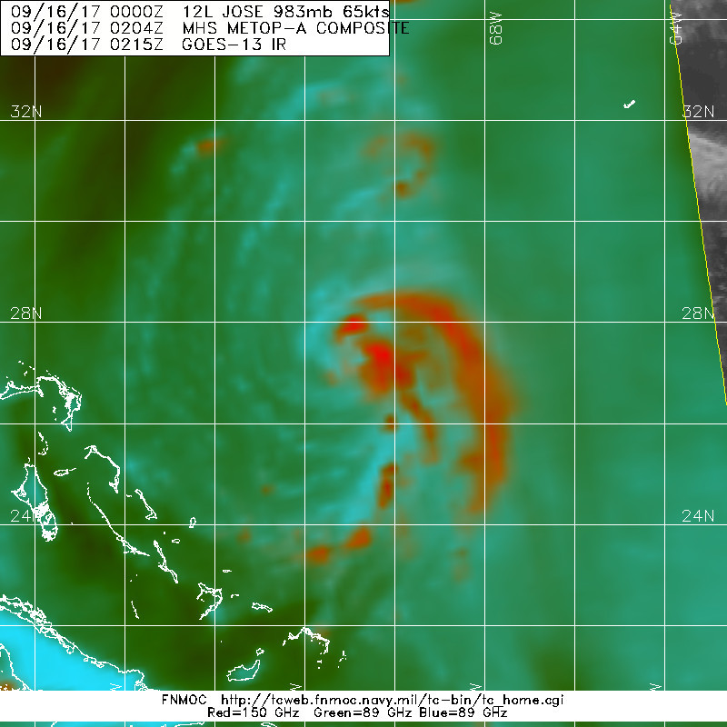
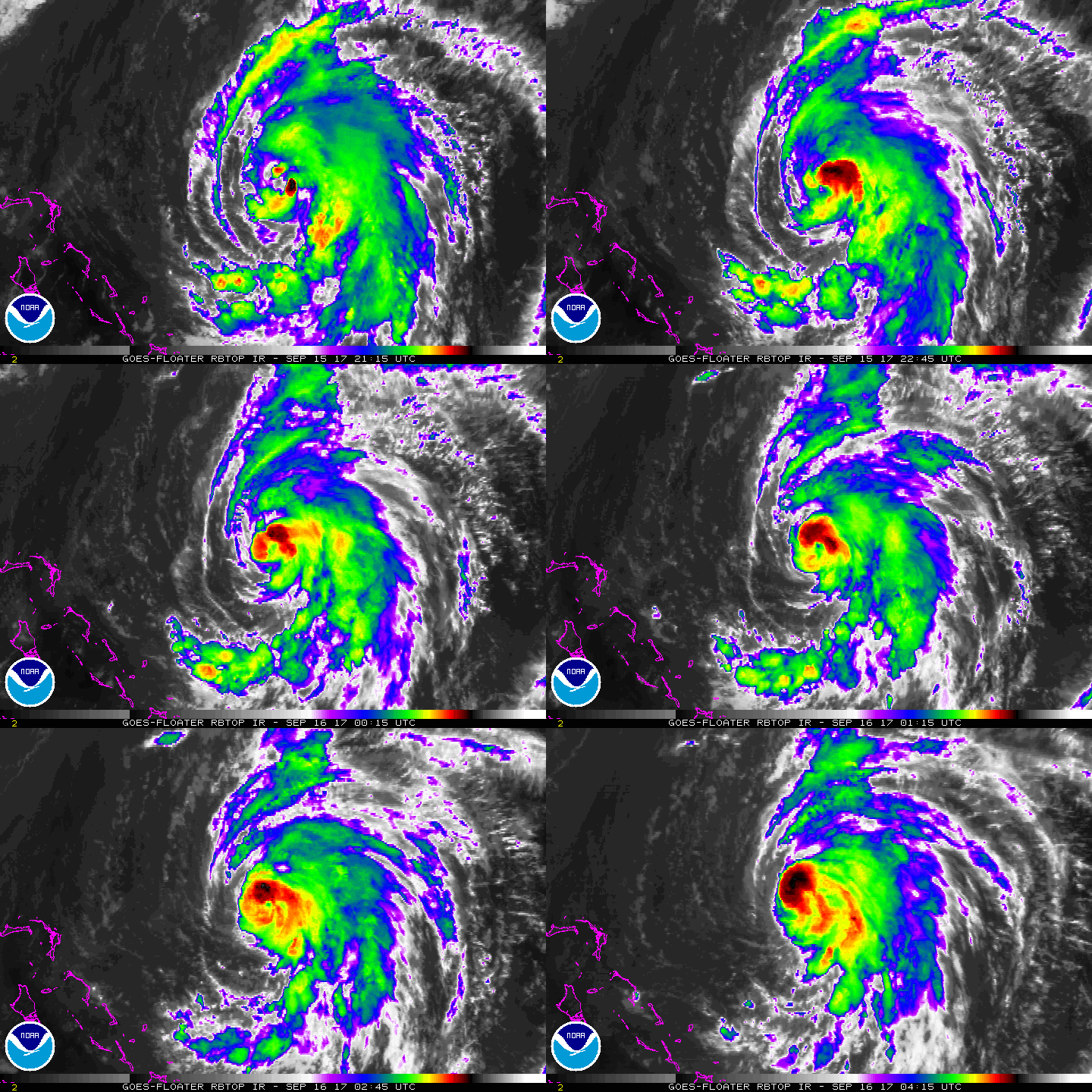
Since the reconnaissance flight earlier this afternoon, convection
within the inner-core of Jose has increased in coverage and
organization.  A banding eye appears to be forming, and a warm spot
is apparent in IR imagery near the center of the cyclone.  Dvorak
classifications at 0000 UTC still supported an intensity of 65 kt,
but given the increase in organization since then, the initial
intensity has been increased to 70 kt.  Additional strengthening is
still expected for at least the next 24 to 36 h.  After that time,
an increase in southwesterly shear and gradually cooling SSTs are
still expected to cap the intensification and eventually cause Jose
to gradually weaken.  The official intensity forecast remains a
little above the model consensus for the first 48 h, and is close
after that.

Jose continues to move toward the northwest, and the initial motion
estimate is 305/8 kt.  The main source of uncertainty in the track
forecast is at days 4 and 5, since the global models disagree on the
speed at which Jose will move northward along the western edge of
the subtropical ridge.  The GFS continues to show a faster movement,
which allows Jose to pass very close to the U.S. east coast before
an approaching trough forces the cyclone to turn more toward the
northeast.  On the other hand, the ECMWF shows a slower track, so
the trough steers the hurricane farther east.  The NHC forecast has
not been changed substantially and is still just a touch slower than
the model consensus, out of respect to the ECMWF.  When the 00Z
ECMWF and UKMET models become available tonight, it could shed more
light on the future speed of the hurricane.  It is still important
to note that the average NHC track errors at days 4 and 5 are about
175 and 225 miles, respectively, and this error could be in the
speed of the hurricane (along track error).

While the official track forecast keeps the center of Jose offshore
for the next few days, all of the global models show the hurricane
becoming rather large by late this weekend as it moves to the east
of North Carolina.  For that reason, a tropical storm watch may be
needed for a portion of the North Carolina coast tomorrow.

KEY MESSAGES:

1. Swells generated by Jose are affecting Bermuda, the Bahamas, the
northern coasts of Hispaniola and Puerto Rico, and the southeast
coast of the United States, and will spread northward, reaching the
mid-Atlantic coast and the coast of southern New England during the
next few days.  These swells are likely to cause dangerous surf and
rip current conditions.

2. Although the center of Jose is forecast to pass well east of the
North Carolina coast early next week, tropical-storm-force winds are
expected to extend well west of the center and could approach the
North Carolina Outer Banks on Monday.  Farther north along the U.S.
east coast, the chance of some direct impacts from Jose is
increasing, but it is too soon to determine their exact magnitude
and location.  Interests along the U.S. east coast from North
Carolina to New England should monitor the progress of Jose through
the weekend.


FORECAST POSITIONS AND MAX WINDS

INIT  16/0300Z 27.4N  71.0W   70 KT  80 MPH
12H  16/1200Z 28.1N  71.9W   75 KT  85 MPH
24H  17/0000Z 29.2N  72.3W   80 KT  90 MPH
36H  17/1200Z 30.6N  72.2W   80 KT  90 MPH
48H  18/0000Z 32.0N  72.0W   75 KT  85 MPH
72H  19/0000Z 34.6N  71.8W   70 KT  80 MPH
96H  20/0000Z 37.5N  71.0W   65 KT  75 MPH
120H  21/0000Z 41.0N  68.5W   55 KT  65 MPH

$$
Forecaster Zelinsky

NNNN
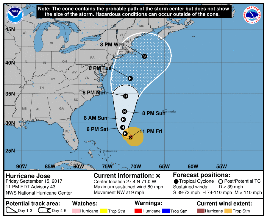
025822_5day_cone_no_line_and_wind.png 20170916.0204.metopa.89rgb.12L.JOSE.65kts.983mb.27.2N.70.7W.100pc.jpg rbtop-animated (10).gif


回復

使用道具 舉報

快速回覆
您需要登錄後才可以回帖 登錄 | 立即加入

本版積分規則

本平台僅供學術討論之用,預報應以氣象局為準

威普網站虛擬主機贊助公司

臺灣第一個天氣類型社群平台 即時天氣資訊、精準颱風動態

線上客服
FB傳送訊息
廣告行銷
精準行銷 物超所值
官方粉專
發佈 快速回復 返回頂部 返回列表