開啟輔助訪問
 找回密碼
 立即加入

13L.Katia 中心登陸墨西哥 逐漸減弱消散

簽到天數: 601 天

[LV.9]以壇為家II

2017-9-5 08:24 | 顯示全部樓層
本帖最後由 霧峰追風者 於 2017-12-12 07:50 編輯

  二級颶風  
編號:13 L
名稱:Katia
800px-Katia_2017-09-08_1930Z.jpg
  基本資料  
擾動編號日期:2017 09 05 08
升格日期  :2017 09 06 17
撤編日期  :2017 09 00 00
登陸地點  :墨西哥 維拉克魯斯州 特科盧特拉

  巔峰時期資料  
近中心最強風速
國家颶風中心(NHC):90 kts
海平面最低氣壓 :972 百帕

  過去路徑圖  
13L-Katia.png
  擾動編號資料  
95L-INVEST-25kts-1009mb-21.7N-96.2W

20170904.2345.goes-13.ir.95L.INVEST.25kts.1009mb.21.7N.96.2W.100pc.jpg
avn-animated.gif

  NHC : 40%  
2. A trough of low pressure located over the southwestern Gulf of
Mexico is producing disorganized showers and thunderstorms.
Environmental conditions are marginally conducive for some
slow development of this system while it drifts west-northwestward
and remains over the southwestern Gulf of Mexico during the next
few days.
* Formation chance through 48 hours...medium...40 percent.
* Formation chance through 5 days...medium...50 percent.


two_atl_2d2 (3).png

以上資料來自:NHC、颱風論壇整理製作

評分

參與人數 1水氣能量 +15 收起 理由
jwpk9899 + 15

查看全部評分

回復

使用道具 舉報

簽到天數: 601 天

[LV.9]以壇為家II

霧峰追風者|2017-9-6 02:49 | 顯示全部樓層
本帖最後由 霧峰追風者 於 2017-9-6 02:59 編輯

NHC 展望提升至70%。
1. A well-defined area of low pressure has formed about 50 miles east
of Tampico, Mexico in the southwestern Gulf of Mexico in
association with numerous showers and thunderstorms.  Environmental
conditions are conducive for gradual development, and
this system is likely to become a tropical depression during the
next couple of days while it meanders over the southwestern Gulf of
Mexico. Regardless of development, heavy rains associated with this
disturbance are likely over portions of eastern Mexico during the
remainder of the week.
* Formation chance through 48 hours...high...70 percent.
* Formation chance through 5 days...high...80 percent.

two_atl_2d0.png rbtop-animated (19).gif


回復

使用道具 舉報

簽到天數: 3291 天

[LV.Master]伴壇終老

t02436|2017-9-6 07:59 | 顯示全部樓層
升格13L。
ZCZC MIATCDAT3 ALL
TTAA00 KNHC DDHHMM

Tropical Depression Thirteen Discussion Number   1
NWS National Hurricane Center Miami FL       AL132017
400 PM CDT Tue Sep 05 2017

The small area of low pressure in the southwestern Gulf of Mexico
has become better organized during the past several hours, with deep
convection forming over the center.  ASCAT data showed a
well-defined circulation with winds of about 30 kt.  Thus, a
tropical depression has formed, with maximum winds estimated at 30
kt.  While the cyclone is currently experiencing westerly shear,
most of the guidance indicate the shear should gradually lessen.
Combined with the very warm Gulf of Mexico waters, this should
promote strengthening.  The shear could increase again in a few
days, so the intensity forecast will be leveled off at that time.
The NHC wind speed prediction is near or slightly higher than the
model consensus, but could be conservative.

The depression has been drifting eastward during the day.  For the
next couple of days, the cyclone isn't expected to move much as it
is caught in an area of light winds in the mid-levels.  By Friday, a
ridge should build over Texas and the northwestern Gulf of Mexico,
which is likely to steer the system southwestward at a faster pace.
The NHC forecast is on the southern side of the guidance, since
models in that area tend to have a northward bias, between the
corrected consensus and the ECMWF.


FORECAST POSITIONS AND MAX WINDS

INIT  05/2100Z 22.4N  96.7W   30 KT  35 MPH
12H  06/0600Z 22.4N  96.3W   35 KT  40 MPH
24H  06/1800Z 22.2N  95.6W   45 KT  50 MPH
36H  07/0600Z 21.8N  95.2W   50 KT  60 MPH
48H  07/1800Z 21.4N  95.2W   55 KT  65 MPH
72H  08/1800Z 20.9N  95.6W   55 KT  65 MPH
96H  09/1800Z 19.7N  97.2W   30 KT  35 MPH...INLAND
120H  10/1800Z...DISSIPATED

$$
Forecaster Blake

NNN
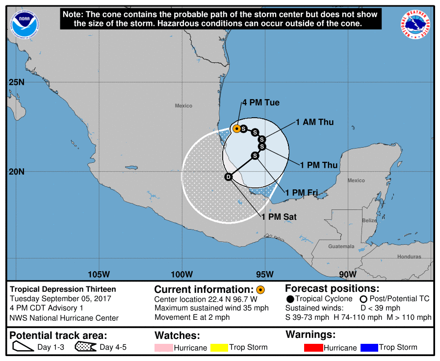
204106_5day_cone_with_line.png

回復

使用道具 舉報

簽到天數: 601 天

[LV.9]以壇為家II

霧峰追風者|2017-9-6 16:51 | 顯示全部樓層
NHC 命名"KATIA",逐漸增強,巔峰上看60KT,緩慢移動趨向墨西哥中部。
000
WTNT43 KNHC 060844
TCDAT3

Tropical Storm Katia Discussion Number   3
NWS National Hurricane Center Miami FL       AL132017
400 AM CDT Wed Sep 06 2017

Conventional satellite imagery shows improved organization of the
cloud pattern during the past several hours, with recent cold cloud
top of -80C associated with deep convective bursts near the surface
center. An earlier SSMI/S microwave pass also revealed a developing
curved band feature in the eastern portion of the cyclone.
Additionally, a 0306 UTC ASCAT-B overpass indicated winds of 35 kt
in the aforementioned rain band.  A Dvorak satellite intensity
estimate of 35 kt from TAFB and the scatterometer wind data support
upgrading the depression to Tropical Storm Katia at this time.
The SHIPS model and the CIMSS shear analysis indicate westerly shear
impinging the western side of Katia, but the flow aloft appears to
be more diffluent now, indicative of the recent deep convective
outbreak.  Guidance continues to suggest that the shear will relax
in about 36 hours which should allow Katia to strengthen, possibly
to a hurricane as indicated in the HWRF forecast.  There are no
changes to the intensity forecast from the previous advisory, and
it's based on the IVCN multi-model.

The initial motion is estimated to be east-southeastward, or 110/2
kt. Katia has been drifting generally in this direction during the
past several hours within weak steering currents associated with a
mid-tropospheric trough digging southwestward from the Mississippi
Valley.  Later today, Katia should begin a gradual turn
southeastward and southwestward around the 36 hour period as a
mid-level ridge builds over the western gulf from Texas.  The
official forecast basically splits the guidance envelope and is
hedged toward the HFIP Corrected Consensus Model.


FORECAST POSITIONS AND MAX WINDS

INIT  06/0900Z 22.1N  96.3W   35 KT  40 MPH
12H  06/1800Z 21.9N  96.0W   40 KT  45 MPH
24H  07/0600Z 21.6N  95.6W   50 KT  60 MPH
36H  07/1800Z 21.3N  95.4W   55 KT  65 MPH
48H  08/0600Z 21.1N  95.6W   60 KT  70 MPH
72H  09/0600Z 20.4N  96.7W   60 KT  70 MPH
96H  10/0600Z 19.2N  98.7W   25 KT  30 MPH...POST-TROP/INLAND
120H  11/0600Z...DISSIPATED

$$
Forecaster Roberts
024229_5day_cone_no_line_and_wind.png rbtop-animated (21).gif


回復

使用道具 舉報

簽到天數: 601 天

[LV.9]以壇為家II

霧峰追風者|2017-9-7 06:55 | 顯示全部樓層
本帖最後由 霧峰追風者 於 2017-9-7 06:56 編輯

NHC 根據實測達標升一級颶風,緩慢移動朝向墨西哥中部。
000
WTNT43 KNHC 062054
TCDAT3

Hurricane Katia Discussion Number   5
NWS National Hurricane Center Miami FL       AL132017
400 PM CDT Wed Sep 06 2017

An Air Force reconnaissance plane just investigated Katia and found
a much better organized tropical cyclone with a partial eyewall. It
also measured a flight-level wind of 71 kt and 66 kt with the SFMR.
Based on these data and the improved satellite presentation, Katia
is upgraded to a hurricane with 65 kt winds.


The upper-level wind pattern is becoming more favorable, and that
can be observed by the expansion of the outflow. All models continue
to favor intensification, and in fact, the SHIPS RI index gives a
63 percent chance of a 30-kt wind increase in 24 hours. The NHC
forecast calls for strengthening but at this time is not as high as
some of the guidance.

Katia is embedded within very weak steering currents, and it is now
moving slowly toward the southeast at about 3 kt. The hurricane is
forecast to meander in the southwestern Gulf of Mexico for the next
day or two. After that time the global models develop a ridge over
the northern Gulf of Mexico and this flow pattern will steer Katia
southwestward toward the state of Veracruz. The NHC forecast is
basically on top of the multi-model consensus and follows the trend
of the HFIP corrected consensus HCCA.

Given the upward intensity trend and the forecast track toward
the coast, the government of Mexico has issued a hurricane watch
for a portion of the coast of the state of Veracruz.  Katia is also
forecast to bring torrential rains primarily to the state of
Veracruz during the next few days.


FORECAST POSITIONS AND MAX WINDS

INIT  06/2100Z 21.7N  95.1W   65 KT  75 MPH
12H  07/0600Z 21.5N  94.7W   70 KT  80 MPH
24H  07/1800Z 21.3N  94.7W   75 KT  85 MPH
36H  08/0600Z 21.1N  95.0W   80 KT  90 MPH
48H  08/1800Z 20.9N  95.9W   80 KT  90 MPH
72H  09/1800Z 19.5N  98.0W   25 KT  30 MPH...POST-TROP/INLAND
96H  10/1800Z...DISSIPATED

$$
Forecaster Avila

205837_5day_cone_no_line_and_wind.png rbtop-animated (23).gif


另外北大西洋達成同一時間有三個颶風等級的罕見紀錄,雲圖左邊為13L.Katia
two_atl_0d0.png 三颶共舞.png


回復

使用道具 舉報

簽到天數: 4695 天

[LV.Master]伴壇終老

s6815711|2017-9-8 00:42 | 顯示全部樓層
ZCZC MIATCDAT3 ALL
TTAA00 KNHC DDHHMM

Hurricane Katia Discussion Number   8
NWS National Hurricane Center Miami FL       AL132017
1000 AM CDT Thu Sep 07 2017

An Air Force Hurricane Hunter aircraft found that the central
pressure had dropped to 982 mb and maximum SFMR-observed surface
winds were close to 70 kt.  Therefore 70 kt will be retained for the
current intensity.  Vertical wind shear should remain low over the
southwest Gulf of Mexico for the next couple of days and the global
models show well-developed upper-level outflow over the tropical
cyclone.  Thus, further strengthening is likely up to landfall.  The
official intensity forecast is somewhat higher than the model
consensus and Katia could approach major hurricane status before it
crosses that coast.

Fixes from the Hurricane Hunter aircraft show essentially no motion
over the last several hours.  A mid-level ridge is likely to build
to the north of Katia during the next day or so.  This should
induce a west-southwestward motion beginning tonight or early
Friday, leading to landfall by late Friday or early Saturday.  The
official track forecast is similar to the previous one and close to
the model consensus.

FORECAST POSITIONS AND MAX WINDS

INIT  07/1500Z 21.6N  94.6W   70 KT  80 MPH
12H  08/0000Z 21.4N  95.0W   80 KT  90 MPH
24H  08/1200Z 21.2N  95.5W   90 KT 105 MPH
36H  09/0000Z 20.7N  96.5W   90 KT 105 MPH
48H  09/1200Z 19.9N  97.9W   40 KT  45 MPH...INLAND
72H  10/1200Z...DISSIPATED

$$
Forecaster Pasch

NNNN
143754_5day_cone_no_line_and_wind.png


預測巔峰強度稍微上修 預估兩天後登陸
回復

使用道具 舉報

簽到天數: 601 天

[LV.9]以壇為家II

霧峰追風者|2017-9-9 06:55 | 顯示全部樓層
即將登陸墨西哥,強度也來到顛峰90KT,還好跟昨日M8.1強震重災區還有一小段距離....
ZCZC MIATCDAT3 ALL
TTAA00 KNHC DDHHMM

Hurricane Katia Discussion Number  13
NWS National Hurricane Center Miami FL       AL132017
Issued by the NWS Weather Prediction Center College Park MD
400 PM CDT Fri Sep 08 2017

Satellite imagery continues to show Katia becoming better organized
with the formation of a small, cloud-filled eye this afternoon.
The initial wind speed has been increased to 90 knots based on the
subjective Dvorak estimates from both TAFB and SAB.  Another
reconnaissance plane is expected to arrive in a few hours to check
on the winds of Katia.

Additional strengthening is possible prior to landfall, and Katia
could still become a major hurricane, but there is only about 6
hours left for this to occur. After landfall, rapid weakening is
expected, and Katia is forecast to dissipate over the rugged terrain
of the Sierra Madre mountains between 24 and 36 hours.

Katia has moved westward during the day, but a longer-term motion is
still west-southwestward at 6 kt.  The official track forecast was
shifted to the north near landfall due to the more westerly track
this afternoon. The new forecast then resumes a more southwesterly
track based on northerly mid/upper-level flow seen on infrared
imagery ahead of the storm and model guidance.

In addition to a dangerous storm surge and hurricane-force winds,
very heavy rains associated with Katia are expected to affect
eastern Mexico. These rains will likely cause life-threatening flash
floods and mudslides.


FORECAST POSITIONS AND MAX WINDS

INIT  08/2100Z 21.0N  96.5W   90 KT 105 MPH
12H  09/0600Z 20.8N  97.3W   85 KT 100 MPH...INLAND
24H  09/1800Z 20.0N  98.0W   30 KT  35 MPH...INLAND
36H  10/0600Z...DISSIPATED

$$
Forecaster Bann/Blake

NNNN
024932_5day_cone_no_line_and_wind.png bd-animated (2).gif avn-animated.gif

另外補充一張13L.Katia巔峰照( 90kt ),與11L.Irma ( 135kt ),12L.Jose ( 130kt ) 三颶風共舞合照。
irng8kml.GIF


回復

使用道具 舉報

簽到天數: 3291 天

[LV.Master]伴壇終老

t02436|2017-9-9 10:52 | 顯示全部樓層
中心登陸了,登陸前受到乾空氣影響迅速減弱到C1下限,北大三MH宣告無緣成真。
000
WTNT43 KNHC 090236
TCDAT3

Hurricane Katia Discussion Number  14
NWS National Hurricane Center Miami FL       AL132017
Issued by the NWS Weather Prediction Center College Park MD
1000 PM CDT Fri Sep 08 2017


Satellite imagery shows Katia has become much less organized over
the past several hours with a shrinking area of warming cloud tops.
The weakening of Katia could be due to drier air wrapping around the
cyclone's western side
, which was noted in satellite-based layered
precipitable water products.  Reconnaissance aircraft has reported
a significant northeast tilt of the circulation with height, a
sign of southwesterly vertical wind shear.  The initial wind speed
has been decreased to 65 knots based on a blend of subjective Dvorak
estimates from TAFB and SAB and is close to SFMR wind observations
from Air Force reconnasissance aircraft currently sampling the
storm.

Katia is currently making landfall north of Tecolutla, Mexico.
Rapid weakening is expected from here on out, and Katia is forecast
to dissipate over the rugged terrain of the Sierra Madre mountains
on Saturday.  Katia has made a turn to the west-southwest at 6 kt.
The official track forecast remains consistent with the previous
advisory. The weakening hurricane is expected to continue moving
west-southwest until dissipation.

Very heavy rains associated with Katia are expected to affect
eastern Mexico.  These rains will likely cause life-threatening
flash floods and mudslides.


FORECAST POSITIONS AND MAX WINDS

INIT  09/0300Z 20.6N  97.2W   65 KT  75 MPH
12H  09/1200Z 20.2N  97.9W   40 KT  45 MPH...INLAND
24H  10/0000Z 19.7N  98.9W   25 KT  30 MPH...DISSIPATED

$$
Forecaster Roth/Lamers

025349_5day_cone_no_line_and_wind.png

rbtop-animated.gif

recon_AF306-0513A-KATIA.png

recon_AF306-0513A-KATIA_timeseries.png
回復

使用道具 舉報

12下一頁
快速回覆
您需要登錄後才可以回帖 登錄 | 立即加入

本版積分規則

霧峰追風者

    主題

    帖子

    221萬

    積分

    16級[四級颶風]

    Rank: 16Rank: 16Rank: 16Rank: 16

16級[四級颶風]

發訊息

本平台僅供學術討論之用,預報應以氣象局為準

威普網站虛擬主機贊助公司

臺灣第一個天氣類型社群平台 即時天氣資訊、精準颱風動態

線上客服
FB傳送訊息
廣告行銷
精準行銷 物超所值
官方粉專
發佈 快速回復 返回頂部 返回列表