開啟輔助訪問
 找回密碼
 立即加入

98S(30U).Greg 逐漸消散

簽到天數: 4681 天

[LV.Master]伴壇終老

2017-4-29 22:18 | 顯示全部樓層
本帖最後由 s6815711 於 2017-5-9 19:54 編輯

  一級熱帶氣旋  
編號:30 U ( 98 S )
名稱:Greg


  基本資料  
擾動編號日期:2017 04 29 21

JTWC升格日期:2017 04 30 09
命名日期  :2017 04 30 15

撤編日期  :2017 05 04 22
登陸地點  :暫無


  巔峰時期資料  
近中心最強風速
澳洲氣象局 (BoM) :  35 kt
聯合颱風警報中心(JTWC): 30 kt ( TS )
海平面最低氣壓    :1000 百帕

  過去路徑圖  

  討論帖圖片  

98S.INVEST.15kts.NAmb.9.0S.102.0E
20170429.1300.msg-1.ir.98S.INVEST.15kts.1010mb.9S.102E.100pc.jpg


以上資料來自:BoM、JTWC、颱風論壇整理製作

評分

參與人數 1水氣能量 +15 收起 理由
jwpk9899 + 15

查看全部評分

回復

使用道具 舉報

簽到天數: 173 天

[LV.7]常住居民III

W環|2017-4-29 22:49 | 顯示全部樓層
本帖最後由 W環 於 2017-4-30 08:18 編輯

仍然有一些季風槽的特徵,附近也有不少連繫且獨立的正渦度
image.gif


回復

使用道具 舉報

簽到天數: 3291 天

[LV.Master]伴壇終老

t02436|2017-4-30 09:43 | 顯示全部樓層
直接評級Medium
B. TROPICAL DISTURBANCE SUMMARY:
      (1) AN AREA OF CONVECTION (INVEST 98S) HAS PERSISTED NEAR 9.9S
101.6E, APPROXIMATELY 305 NM NORTH-NORTHEAST OF COCOS ISLAND.
ANIMATED ENHANCED INFRARED SATELLITE IMAGERY SHOWS A SLIGHTLY
ELONGATED CIRCULATION WITH PERSISTENT CONVECTION OVER AND WRAPPING
INTO THE CENTER. A 291835Z AMSR-2 89GHZ MICROWAVE IMAGE SHOWS DEEP
CONVECTION LOCATED IN BANDS WRAPPING INTO THE CENTER OF THE
CIRCULATION. THE DISTURBANCE IS CURRENTLY LOCATED IN AN AREA OF GOOD
DIVERGENCE ALOFT WITH A POLEWARD OUTFLOW CHANNEL AND WARM SEA
SURFACE TEMPERATURES (29-30 CELSIUS). THE SYSTEM IS ALSO POSITIONED
IN A NARROW AREA OF LOW (5-10 KNOTS) VERTICAL WIND SHEAR, BUT THE
UPPER-LEVEL JET JUST TO THE SOUTH IS CREATING A STEEP SHEAR GRADIENT
AND POTENTIALLY HOSTILE ENVIRONMENT. MODELS SHOW THE SYSTEM MOVING
GENERALLY TO THE WEST OVER THE NEXT SEVERAL DAYS, HOWEVER MODELS ARE
MIXED AS TO WHETHER THE SYSTEM WILL DEVELOP. MAXIMUM SUSTAINED
SURFACE WINDS ARE ESTIMATED AT 10 TO 15 KNOTS. MINIMUM SEA LEVEL
PRESSURE IS ESTIMATED TO BE NEAR 1010 MB. THE POTENTIAL FOR THE
DEVELOPMENT OF A SIGNIFICANT TROPICAL CYCLONE WITHIN THE NEXT 24
HOURS IS MEDIUM.

abiosair.jpg

98S_gefs_latest.png

20170430.0050.himawari-8.ircolor.98S.INVEST.30kts.1005mb.10.3S.101.7E.100pc.jpg

點評

說時遲那時快,馬上發布TCFA [attachimg]69962[/attachimg] [attachimg]69963[/attachimg]  詳情 回復 發表於 2017-4-30 09:51
回復

使用道具 舉報

簽到天數: 3291 天

[LV.Master]伴壇終老

t02436|2017-4-30 09:51 | 顯示全部樓層

說時遲那時快,馬上發布TCFA
sh9817.gif

rbtop-animated.gif

點評

根本就是急速發展中,強度上看100kts  發表於 2017-4-30 12:15
好快  發表於 2017-4-30 10:04
回復

使用道具 舉報

簽到天數: 3291 天

[LV.Master]伴壇終老

t02436|2017-4-30 14:58 | 顯示全部樓層
補充 BoM 03Z編號30U,並預測等等就要命名了。
IDW27700
TROPICAL CYCLONE TECHNICAL BULLETIN: AUSTRALIA - WESTERN REGION
Issued by PERTH TROPICAL CYCLONE WARNING CENTRE
at: 0309 UTC 30/04/2017
Name: Tropical Low  
Identifier: 30U
Data At: 0000 UTC
Latitude: 10.0S
Longitude: 101.8E
Location Accuracy: within 30 nm [55 km]
Movement Towards: south southwest [206 deg]
Speed of Movement: 2 knots [4 km/h]
Maximum 10-Minute Wind: 30 knots [55 km/h]
Maximum 3-Second Wind Gust: 45 knots [85 km/h]
Central Pressure: 1006 hPa
Radius of 34-knot winds NE quadrant:   
Radius of 34-knot winds SE quadrant:   
Radius of 34-knot winds SW quadrant:   
Radius of 34-knot winds NW quadrant:   
Radius of 48-knot winds NE quadrant:   
Radius of 48-knot winds SE quadrant:   
Radius of 48-knot winds SW quadrant:   
Radius of 48-knot winds NW quadrant:   
Radius of 64-knot winds:   
Radius of Maximum Winds:   
Dvorak Intensity Code: T2.5/2.5/D1.5/24HRS STT : D0.5/06HRS
Pressure of outermost isobar: 1010 hPa
Radius of outermost closed isobar: 90 nm [165 km]
FORECAST DATA
Date/Time    : Location    : Loc. Accuracy: Max Wind   : Central Pressure
[UTC]        : degrees     :      nm  [km]: knots[km/h]: hPa
+06:  30/0600: 10.2S 101.6E:     040 [080]:  035  [065]: 1002
+12:  30/1200: 10.3S 101.0E:     055 [100]:  040  [075]: 1002
+18:  30/1800: 10.4S 100.3E:     065 [125]:  045  [085]: 1000
+24:  01/0000: 10.4S  99.5E:     080 [145]:  045  [085]:  997
+36:  01/1200: 10.1S  97.6E:     100 [185]:  040  [075]: 1000
+48:  02/0000: 10.2S  95.5E:     120 [220]:  030  [055]: 1006
+60:  02/1200: 10.1S  93.7E:     140 [255]:  030  [055]: 1005
+72:  03/0000: 10.4S  92.0E:     155 [290]:  025  [045]: 1008
+96:  04/0000: 10.7S  88.4E:     200 [370]:  025  [045]: 1008
+120: 05/0000: 12.4S  85.6E:     290 [535]:  025  [045]: 1008
REMARKS:
The tropical low was located using microwave imagery and animated visible and
infrared imagery with some confidence.

Microwave imagery overnight showed a small tight circulation in the low levels
and upper levels [1806UTC and 2119UTC passes].  Dvorak is problematic due to the
small size and rapid development of the system. Initial classification could be
re-analysed to 00Z Saturday. Based on this and a D+ development, FT and CI are
2.5 at 00Z. Soon to arrive ASCAT should provide more information as to the
surface circulation.

Current intensity is set to 30 knots based on a CI of 2.5.

Shear is currentkly 5 to 10 knots [low] and forecast to remain that way until
mid Monday when it starts to increase. Thus, a strengthening trend is forecast
for the short term. Due to the small size, the system may reach category 2
tonight. A weakening trend is forecast for late Monday. The track has the system
moving over cooler SST's which should further weaken the system.

Track is based on a concensus of global models [ECMWF, UK, US-GFS and ACCESS-G].

Copyright Commonwealth of Australia
==
The next bulletin for this system will be issued by: 30/0730 UTC by Perth TCWC.
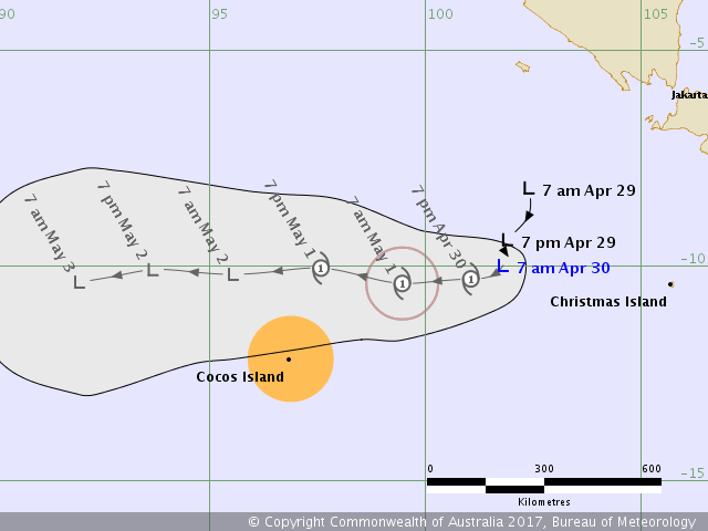
IDW60284.png

點評

命名Greg。 [attachimg]69967[/attachimg]  詳情 回復 發表於 2017-4-30 15:02
回復

使用道具 舉報

簽到天數: 3291 天

[LV.Master]伴壇終老

t02436|2017-4-30 15:02 | 顯示全部樓層
t02436 發表於 2017-4-30 14:58
補充 BoM 03Z編號30U,並預測等等就要命名了。

命名Greg。
IDW24400

Australian Government Bureau of Meteorology
Western Australia
Tropical Cyclone Warning Centre

Media: The Standard Emergency Warning Signal should NOT be used with this warning.

PRIORITY
TROPICAL CYCLONE ADVICE NUMBER 2
Issued at 2:56 pm WST on Sunday 30 April 2017
Headline:
Tropical Cyclone Greg to move west and pass just north of the Cocos Islands late Monday night or early Tuesday.

Areas Affected:
Warning Zone
None.

Watch Zone
the Cocos (Keeling) Islands.

Cancelled Zone
None.

Details of Tropical Cyclone Greg at 12:30 pm CCT:
Intensity: Category 1, sustained winds near the centre of 65 kilometres per hour with wind gusts to 95 kilometres per hour.

Location: within 35 kilometres of 10.4 degrees South 101.3 degrees East, estimated to be 525 kilometres east northeast of Cocos Island and 480 kilometres west of Christmas Island.

Movement: southwest at 12 kilometres per hour.

Tropical Cyclone Greg developed quickly overnight and during this morning. It may reach category 2 intensity tonight as it continues moving generally west but then start weakening later Monday. It is forecast to pass to the north of the Cocos Islands late Monday or early Tuesday.

Hazards:
GALES with gusts to 100 km/hr may develop over the Cocos Islands as early as Monday afternoon if the tropical low takes a more southerly track.

Recommended Action:
The Australian Federal Police advise that there are no community alerts at present.

Communities on Home and West Island should listen for the next advice.

Next Advice:
The next advice will be issued by 7:30 pm CCT Sunday 30 April.
Cyclone advices and DFES Alerts are available by dialling 13 DFES (13 3337)

vis-animated.gif
回復

使用道具 舉報

簽到天數: 4681 天

[LV.Master]伴壇終老

s6815711|2017-4-30 20:13 | 顯示全部樓層
強度上望澳式二級熱帶氣旋
IDW60284.png

點評

似乎迅速殞落夭折了,壽命不足2天  發表於 2017-5-1 10:30
回復

使用道具 舉報

簽到天數: 173 天

[LV.7]常住居民III

W環|2017-5-1 10:37 | 顯示全部樓層
JTWC: LOW
abpwsair.jpg

回復

使用道具 舉報

12下一頁
快速回覆
您需要登錄後才可以回帖 登錄 | 立即加入

本版積分規則

本平台僅供學術討論之用,預報應以氣象局為準

威普網站虛擬主機贊助公司

臺灣第一個天氣類型社群平台 即時天氣資訊、精準颱風動態

線上客服
FB傳送訊息
廣告行銷
精準行銷 物超所值
官方粉專
發佈 快速回復 返回頂部 返回列表