開啟輔助訪問
 找回密碼
 立即加入

06L.Fiona 對流稀少 緩慢發展中

簽到天數: 2414 天

[LV.Master]伴壇終老

2016-8-15 11:01 | 顯示全部樓層
  熱帶風暴  
編號:06 L
名稱:Fiona
06L.png

  基本資料  
擾動編號日期:2016 08 15 08
命名日期  :2016 08 18 05
撤編日期  :2016 08 25 13
登陸地點  :

  巔峰時期資料  
近中心最強風速:45  kt ( TS )
海平面最低氣壓:1004 百帕

  過去路徑圖  
TWTYBBS_06L_FIONA_TRACK_t02436_TWTYBBS.png

  討論帖圖片  
98L.INVEST.20kts.1009mb.9.7N.20.4W

20160815.0045.msg-3.ir.98L.INVEST.20kts.1009mb.9.7N.20.4W.100pc.jpg

NHC:10%

1. A tropical wave located over the far eastern Atlantic Ocean a couple
of hundred miles west of the coast of Africa is producing
disorganized showers and thunderstorms.  Some gradual development
of this system is possible during the next few days before
conditions become less favorable by the end of the week.  This
system is forecast to move westward to west-northwestward at about
15 mph over the eastern Atlantic through mid-week.
* Formation chance through 48 hours...low...10 percent
* Formation chance through 5 days...low...20 percent two_atl_2d1.png

以上資料來自:NHC、颱風論壇整理製作

評分

參與人數 1水氣能量 +15 +1 收起 理由
king111807 + 15 + 1 熱帶擾動首帖

查看全部評分

回復

使用道具 舉報

簽到天數: 3279 天

[LV.Master]伴壇終老

t02436|2016-8-16 22:02 | 顯示全部樓層
NHC提升評級至High
1. Satellite images indicate that the large area of cloudiness and
thunderstorms associated with a tropical wave centered about 500
miles west-southwest of the Cabo Verde Islands is gradually becoming
better organized. Conditions appear to be favorable for a tropical
depression to form during the next couple of days while the system
moves toward the west-northwest and then northwest toward the
open waters of the central Atlantic.
* Formation chance through 48 hours...high...70 percent
* Formation chance through 5 days...high...80 percent

two_atl_2d1.png

大部分數值模式看好發展
98L_gefs_latest.png

98L_intensity_latest.png

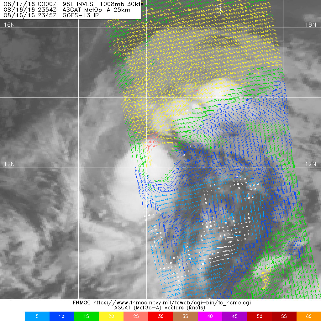
20160816.1201.mtb.ASCAT.wind.98L.INVEST.25kts-1008mb.102N.314W.25km.jpg

回復

使用道具 舉報

簽到天數: 3279 天

[LV.Master]伴壇終老

t02436|2016-8-17 11:50 | 顯示全部樓層
美國海軍19Z發布TCFA
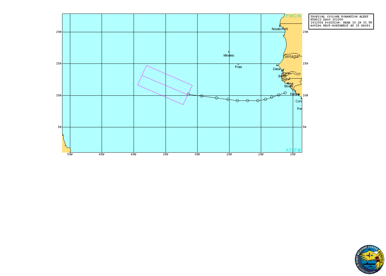
al982016.16081612.gif

NHC 03Z升格06L,預計24小時內命名Fiona。
000
WTNT41 KNHC 170248
TCDAT1

TROPICAL DEPRESSION SIX DISCUSSION NUMBER   1
NWS NATIONAL HURRICANE CENTER MIAMI FL       AL062016
1100 PM AST TUE AUG 16 2016

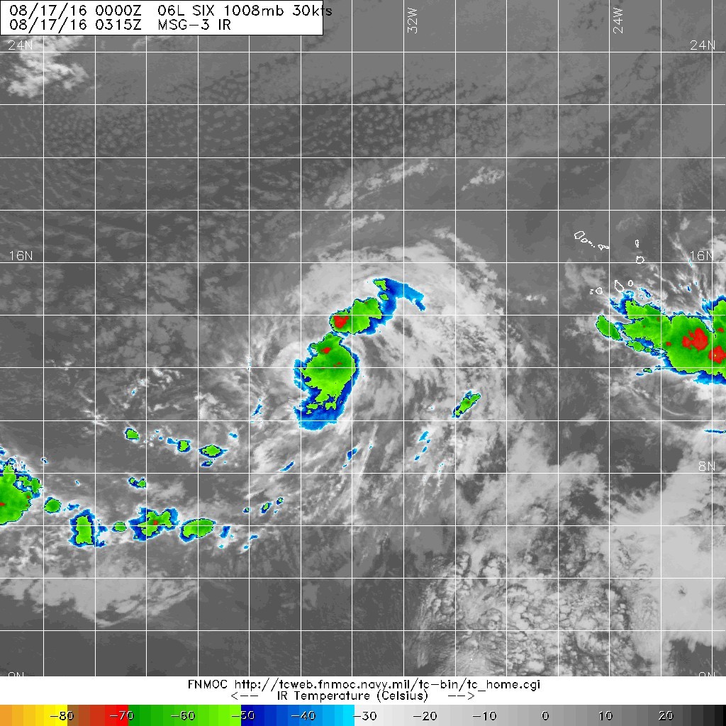
Convective activity associated with the tropical wave and associated
low pressure area over the tropical Atlantic has become more
concentrated and better organized this evening, and a recent ASCAT
overpass indicates that the circulation has become better defined.
Based on these data, this system has been designated a tropical
depression, and advisories are being initiated at this time. The
initial wind speed of 30 kt is supported by the scatterometer data.
Some northeasterly shear is affecting the depression, with the
center located near the northeastern edge of the primary convective
mass.  The shear is forecast to decrease tonight and remain low
during the next couple of days which favors strengthening. However,
dry mid-level air is lurking just to the north of the depression,
and intrusions of this unfavorable airmass could arrest development.
The NHC forecast shows gradual strengthening during the next couple
of days, but it is on the lower side of the guidance, closest to the
LGEM and intensity consensus.  Later in the forecast period,
increasing southwesterly shear being produced by a mid- to
upper-level trough over the central Atlantic is likely to weaken the
tropical cyclone.

The initial motion estimate is a somewhat uncertain 310/12 kt.  The
depression is forecast to move generally northwestward into a
weakness in the subtropical ridge over the central Atlantic. The
track guidance is in relatively good agreement through 48 hours, but
there is a large spread between the GFS-based guidance and the ECMWF
later in the period. The ECMWF and the majority of its ensemble
members depict a much weaker and shallower cyclone that turns
west-northwestward in the low-level flow after 48 hours.  On the
other hand, the GFS, GFS ensemble mean, GFDL, and HWRF take a
stronger cyclone more poleward.  For now, the NHC track is between
these two distinct solutions, and is located just south of the
multi-model consensus at days 4 and 5.


FORECAST POSITIONS AND MAX WINDS

INIT  17/0300Z 12.6N  34.1W   30 KT  35 MPH
12H  17/1200Z 13.7N  35.6W   35 KT  40 MPH
24H  18/0000Z 15.2N  37.2W   40 KT  45 MPH
36H  18/1200Z 16.8N  38.8W   45 KT  50 MPH
48H  19/0000Z 18.1N  40.2W   50 KT  60 MPH
72H  20/0000Z 20.0N  43.2W   50 KT  60 MPH
96H  21/0000Z 22.5N  46.5W   45 KT  50 MPH
120H  22/0000Z 25.0N  50.0W   40 KT  45 MPH

$$
Forecaster Brown
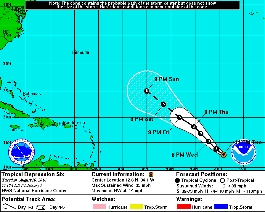
024535W_sm.gif

20160816.2354.mta.ASCAT.wind.98L.INVEST.30kts-1008mb.122N.336W.25km.jpg

20160817.0315.msg-3.ircolor.06L.SIX.30kts.1008mb.12.2N.33.6W.100pc.jpg
回復

使用道具 舉報

簽到天數: 3279 天

[LV.Master]伴壇終老

t02436|2016-8-18 10:24 | 顯示全部樓層
昨天12Z速報一度評價35節,後來15Z正報改回30節而沒有命名,21Z正式命名Fiona。
000
WTNT41 KNHC 172042
TCDAT1

TROPICAL STORM FIONA DISCUSSION NUMBER   4
NWS NATIONAL HURRICANE CENTER MIAMI FL       AL062016
500 PM AST WED AUG 17 2016

During the past 6 hours, the tropical cyclone has made a transition
from a large outer banding pattern to more of a CDO-type feature.

Also, a 1635Z SSMI overpass confirmed the tight inner-core structure
noted in the two earlier ASCAT passes. Dvorak satellite intensity
estimates are T2.5/35 kt from TAFB and SAB, and a 1225Z ASCAT-A
overpass indicated winds of near 35 kt at that time. Based on these
data, the initial intensity is increased to 35 kt and the cyclone is
upgraded to Tropical Storm Fiona.

The initial motion estimate is 305/14 kt. The latest model guidance
has come into much better agreement with the previous track
forecast, with the GFS model shifting a little farther south and the
ECMWF making a significant shift to the north due to that model not
weakening Fiona as much now as compared to previous forecast cycles.
These model changes have resulted in a northward shift in the
consensus models TVCN and GFEX. Given the much better agreement in
the NHC model guidance, the new track forecast was only shifted
slightly southward of the previous advisory track after 72 hours in
order to move closer to the consensus models.

There are no significant changes to the previous intensity forecast.
Fiona is a compact tropical cyclone with a radius of maximum winds
of 15 nmi or less, which makes the storm susceptible to sharp
fluctuations in intensity. The aforementioned SSMI satellite pass
also indicated that the small inner-core region of Fiona now appears
to be insulated from the very dry mid-level air that had earlier
eroded the cyclone's convection. That, along with low shear
conditions and marginal SSTs near 27C, should allow for some gradual
strengthening for the next 36-48 hours, assuming that the cyclone
can mix out any occasional intrusions of dry air. By 72 hours, the
vertical shear is forecast to increase to around 20 kt from the
southwest, which should act to arrest the intensification process
and perhaps even induce some slight weakening. However, by 96 hours
and beyond, the shear is forecast to steadily decrease when the
cyclone will be moving over SSTs greater than 28C. These conditions
could allow for the compact cyclone to maintain a steady intensity
despite being embedded in mid-level humidity values of near 50
percent. The official intensity forecast is similar to the previous
advisory and closely follows the intensity consensus model IVCN
through 48 hours, and then lies just below the Decay-SHIPS model at
72-120 hours.

FORECAST POSITIONS AND MAX WINDS

INIT  17/2100Z 15.1N  37.8W   35 KT  40 MPH
12H  18/0600Z 16.0N  39.0W   40 KT  45 MPH
24H  18/1800Z 17.0N  40.6W   45 KT  50 MPH
36H  19/0600Z 17.8N  42.1W   50 KT  60 MPH
48H  19/1800Z 18.7N  43.8W   50 KT  60 MPH
72H  20/1800Z 20.3N  47.4W   45 KT  50 MPH
96H  21/1800Z 22.6N  51.3W   45 KT  50 MPH
120H  22/1800Z 24.6N  55.0W   45 KT  50 MPH

$$
Forecaster Stewart

204224W_sm.gif

rb-animated.gif
回復

使用道具 舉報

快速回覆
您需要登錄後才可以回帖 登錄 | 立即加入

本版積分規則

本平台僅供學術討論之用,預報應以氣象局為準

威普網站虛擬主機贊助公司

臺灣第一個天氣類型社群平台 即時天氣資訊、精準颱風動態

線上客服
FB傳送訊息
廣告行銷
精準行銷 物超所值
官方粉專
發佈 快速回復 返回頂部 返回列表