開啟輔助訪問
 找回密碼
 立即加入

05E.Darby 長達兩周生命史 橫掃夏威夷

簽到天數: 2414 天

[LV.Master]伴壇終老

2016-7-11 01:39 | 顯示全部樓層
  三級颶風  
編號:05 E
名稱:Darby
05E.png

  基本資料  
擾動編號日期:2016 07 11 01
命名日期  :2016 07 12 23
撤編日期  :2016 07 26 22
登陸地點  :美國 夏威夷 大島

  巔峰時期資料  
近中心最強風速
國家颶風中心(NHC):100 kt ( CAT.3 )
中太平洋颶風中心(CPHC):55 kt ( TS )
海平面最低氣壓962 百帕

  過去路徑圖  
TWTYBBS_05E_DARBY_TRACK_t02436_TWTYBBS.jpg

  討論帖圖片  
97E.INVEST.20kts.1010mb.11.9N.104.4W

20160710.1701.goes-15.ir.97E.INVEST.20kts.1010mb.12.3N.106W.90pc.jpg

NHC:50%
1. A broad area of low pressure located several hundred miles
south-southeast of Manzanillo, Mexico, continues to produce
disorganized shower and thunderstorm activity.  However,
environmental conditions appear conducive for gradual development
of this system, and a tropical depression is likely to form by the
middle of this week while the low moves west-northwestward to
westward at about 10 mph, away from the coast of Mexico.
* Formation chance through 48 hours...medium...50 percent
* Formation chance through 5 days...high...80 percent two_pac_2d1.png

以上資料來自:NHC、CPHC、颱風論壇整理製作

評分

參與人數 1水氣能量 +15 +1 收起 理由
t02436 + 15 + 1

查看全部評分

回復

使用道具 舉報

簽到天數: 3291 天

[LV.Master]伴壇終老

t02436|2016-7-11 09:16 | 顯示全部樓層
美國海軍發布TCFA
ep972016.20160710204935.gif

NHC提升評級至High
1. Numerous showers and thunderstorms are associated with a broad area
of low pressure located several hundred miles south of Manzanillo,
Mexico.  This shower and thunderstorm activity has become more
organized over the last day.  Environmental conditions appear
conducive for continued development of this system, and a tropical
depression is likely to form during the next couple of days while
the low moves westward to west-northwestward at about 10 mph, away
from the coast of Mexico.
* Formation chance through 48 hours...high...70 percent
* Formation chance through 5 days...high...90 percent

two_pac_2d1.png

看來東太要連三發了...
97E_gefs_latest.png

20160711.0045.goes-13.ircolor.97E.INVEST.25kts.1009mb.12.6N.104.9W.100pc.jpg
回復

舉報

簽到天數: 474 天

[LV.9]以壇為家II

劉瑞益@FB|2016-7-12 06:45 | 顯示全部樓層
提示: 作者被禁止或刪除 內容自動屏蔽
回復

舉報

簽到天數: 3291 天

[LV.Master]伴壇終老

t02436|2016-7-13 01:21 | 顯示全部樓層
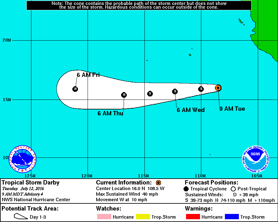
15Z命名Darby
000
WTPZ45 KNHC 121432
TCDEP5

TROPICAL STORM DARBY DISCUSSION NUMBER   4
NWS NATIONAL HURRICANE CENTER MIAMI FL       EP052016
900 AM MDT TUE JUL 12 2016

Recent microwave data indicate that the depression has a well-
defined circulation with the center located to the northeast of the
strongest convection.  Subjective Dvorak intensity estimates are
T2.0 from TAFB and T3.0 from SAB, and the latest ADT estimate is
right at the tropical storm threshold.  A consensus of these values
supports upgrading the depression to a tropical storm, with the
initial intensity set at 35 kt.  After starting off May and June
very quietly, the eastern North Pacific season has already caught
up to where it should be climatologically in terms of named storms.

Darby appears to have turned westward with an initial motion of
270/9 kt.  A subtropical ridge extending westward from northern
Mexico is expected to strengthen during the next three days, which
will steer Darby westward, or even a little south of due west,
during that time.  The model fields continue to show differences in
the strength of the ridge at the end of the forecast period.  The
ECMWF maintains a stronger ridge, with Darby possibly continuing a
westward motion, while the GFS erodes the ridge and allows Darby to
gain some latitude.  The track model envelope has again shifted
southward on this cycle, and the updated NHC track forecast has
been nudged in that direction close to a consensus of the GFS and
ECMWF.

Darby will be moving over a warm pool of SSTs around 29.5 degrees
Celsius during the next 24 hours, and the northeasterly vertical
shear affecting the cyclone should abate a bit.  Depending on
its exact track, Darby could move over the cold wake left behind by
Hurricanes Blas and Celia in a couple of days.  Some shear could
also persist for a few days, therefore only steady strengthening is
expected through 72 hours.  Colder water should then cause
weakening on days 4 and 5.  There is still a lot of spread among
the intensity models, so for now no significant changes are being
made to the previous NHC intensity forecast.  This scenario is a
little above the intensity consensus during the first three days
and then close to the consensus on days 4 and 5.

FORECAST POSITIONS AND MAX WINDS

INIT  12/1500Z 16.0N 108.5W   35 KT  40 MPH
12H  13/0000Z 15.9N 110.0W   40 KT  45 MPH
24H  13/1200Z 15.7N 112.3W   50 KT  60 MPH
36H  14/0000Z 15.5N 114.5W   60 KT  70 MPH
48H  14/1200Z 15.4N 116.8W   65 KT  75 MPH
72H  15/1200Z 15.9N 121.1W   75 KT  85 MPH
96H  16/1200Z 16.5N 125.0W   65 KT  75 MPH
120H  17/1200Z 17.5N 128.5W   55 KT  65 MPH

$$
Forecaster Berg
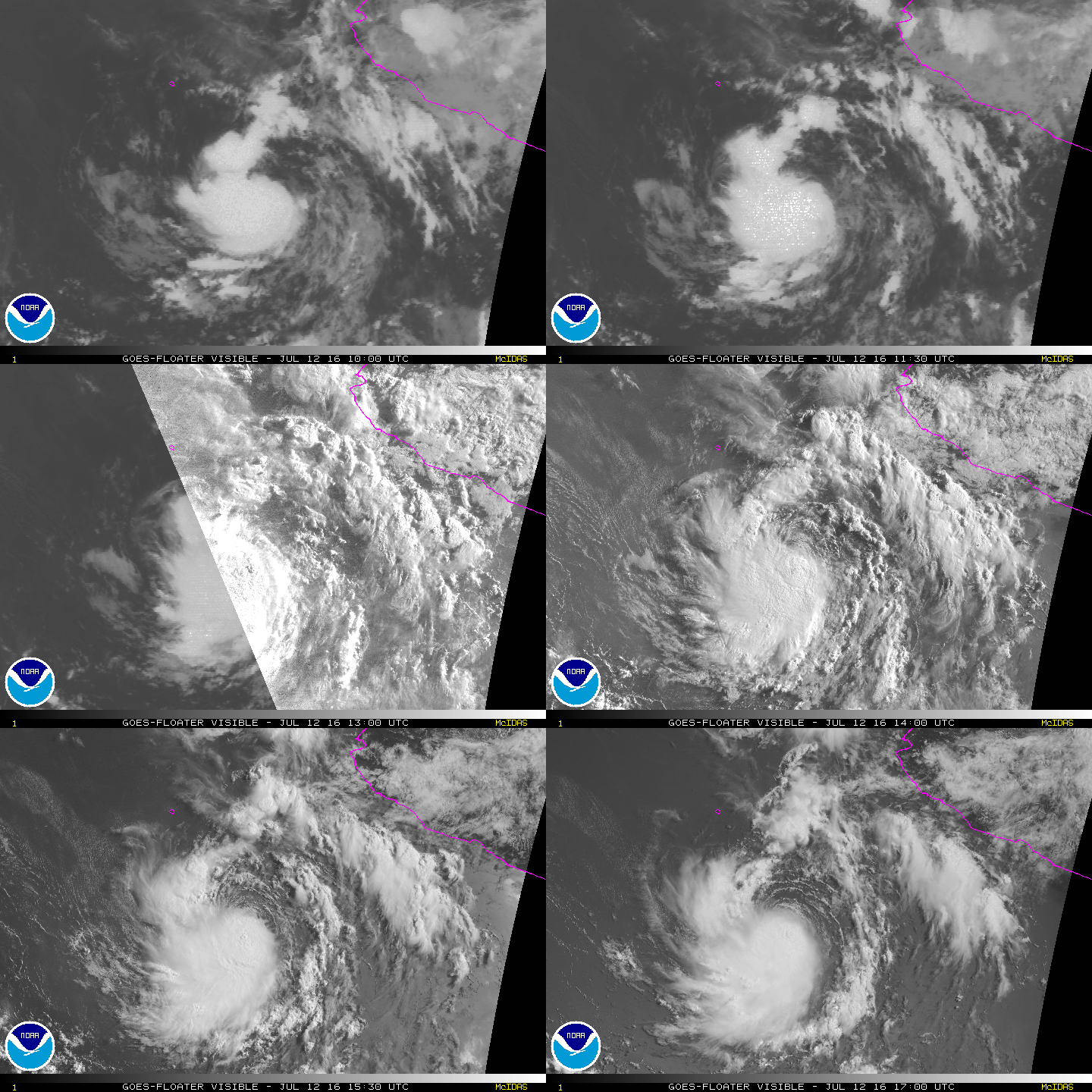
143321W_NL_sm.gif

vis-animated.gif
回復

舉報

簽到天數: 1989 天

[LV.Master]伴壇終老

ben811018|2016-7-13 11:28 | 顯示全部樓層
螢幕擷取畫面 (406).png

東太平洋趕進度
七月已經四連發了!
回復

舉報

簽到天數: 474 天

[LV.9]以壇為家II

劉瑞益@FB|2016-7-22 06:55 | 顯示全部樓層
提示: 作者被禁止或刪除 內容自動屏蔽
回復

舉報

簽到天數: 474 天

[LV.9]以壇為家II

劉瑞益@FB|2016-7-23 13:30 | 顯示全部樓層
提示: 作者被禁止或刪除 內容自動屏蔽
回復

舉報

簽到天數: 3291 天

[LV.Master]伴壇終老

t02436|2016-7-24 11:36 | 顯示全部樓層
中心稍早登陸夏威夷大島
** WTPA63 PHFO 240122 ***
TCUCP3

TROPICAL STORM DARBY TROPICAL CYCLONE UPDATE
NWS CENTRAL PACIFIC HURRICANE CENTER HONOLULU HI   EP052016
320 PM HST SAT JUL 23 2016

...CENTER OF DARBY MAKES LANDFALL...

The center of Tropical Storm Darby made landfall at about 200 PM
HST, or 0000 UTC, along the Kau coast on the Big Island. This is
about 10 miles east-northeast of Pahala and very close to the
location where Tropical Storm Iselle made landfall in 2014.


SUMMARY OF 200 PM HST...0000 UTC...INFORMATION
---------------------------------------------------
LOCATION...19.3N 155.3W
ABOUT 35 MI...55 KM SSW OF HILO HAWAII
ABOUT 220 MI...355 KM SE OF HONOLULU HAWAII
MAXIMUM SUSTAINED WINDS...40 MPH...65 KM/H
PRESENT MOVEMENT...WNW OR 295 DEGREES AT 10 MPH...17 KM/H
MINIMUM CENTRAL PRESSURE...1006 MB...29.70 INCHES

$$
Forecaster Kodama

EP052016W.gif

rbtop-animated.gif

回復

舉報

快速回覆
您需要登錄後才可以回帖 登錄 | 立即加入

本版積分規則

0908morakot

    主題

    帖子

    69萬

    積分

    12級[颶風Hurricane]

    Rank: 12Rank: 12Rank: 12

12級[颶風Hurricane]

發訊息

本平台僅供學術討論之用,預報應以氣象局為準

威普網站虛擬主機贊助公司

臺灣第一個天氣類型社群平台 即時天氣資訊、精準颱風動態

線上客服
FB傳送訊息
廣告行銷
精準行銷 物超所值
官方粉專
發佈 快速回復 返回頂部 返回列表