| BOM认为只是一个Tropic Low |
|
Remarks: The low is no longer expected to develop into a tropical cyclone. However gales may develop in the southern semicircle this evening or overnight. It is not expected to affect the Western Australian coast within the next 48 hours. (此低压已不具有发展成为热带气旋的潜质,但南半圆的暴风尚可能在今晚增强。此低压在未来48小时内不会影响西澳大利亚海岸。) Name: Tropical Low Details(详情): 时间(+8) 等级 经纬度 误差半径 0hr 2 pm February 12 tropical low 20.9S 99.0E 110 +6hr 8 pm February 12 tropical low 21.1S 97.9E 140 +12hr 2 am February 13 tropical low 21.1S 96.7E 165 +18hr 8 am February 13 tropical low 21.1S 95.7E 195 +24hr 2 pm February 13 tropical low 21.0S 94.7E 220 +36hr 2 am February 14 tropical low 20.8S 93.2E 280 +48hr 2 pm February 14 tropical low 20.7S 91.7E 345  |
|
Australian Government Bureau of Meteorology Western Australia Coastal Waters Wind Warning For Cape Preston to Northwest Cape Issued at 3:35 pm WST on Thursday 10 February 2011 Synoptic situation A tropical low well north of the west pilbara coast Pilbara is producing fresh to strong NE'ly winds over northern waters which will ease this evening. Strong Wind Warning Cape Preston to Northwest Cape NE winds 20/30 knots, easing to below 25 knots Thursday evening. Seas to 2.5m. Swell to 1.0m The next warning will be issued by 11:00 pm WST Thursday. |
| FAIR |
|
Australian Government Bureau of Meteorology Western Australia Coastal Waters Wind Warning For Broome to Northwest Cape Issued at 8:00 pm WST on Wednesday 9 February 2011 Synoptic situation A tropical low well north of the west pilbara coast Pilbara will produce fresh to strong NE'ly winds over northern waters. Strong Wind Warning Broome to Barrow Island NE winds 20/30 knots easing below 25 knots east of Cape Preston early Thursday morning to below 25 knots throughout Thursday afternoon. Seas to 2.5m. Swell to 1.0m Strong Wind Warning Barrow Island to Northwest Cape Expect E/NE winds to reach 20/30 knots early Thursday morning, easing below 25 knots Thursday evening. Seas to 2.5m. Swell to 1.0m. The next warning will be issued by 5:00 am WST Thursday. |
|
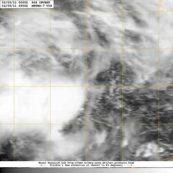
本帖最後由 yuloucn 於 2011-2-9 21:35 編輯 现在系统已经比较有组织,但由于风切较强,强对流区并没有覆盖LLCC 如果照bom的路径移动,南方有一个低风切区,在那里可以得到发展 不过系统的西南又是一片干区,水汽不够,未来72H上望40Kt(bom 的10-min st.) 此系统已经吞并95S http://twtybbs.com/viewthread.php?tid=1036 |