1. Showers and thunderstorms are gradually becoming better organized
in association with an area of low pressure located about 600 miles
southwest of the coast of southwestern Mexico. Environmental
conditions are conducive for continued development, and a tropical
depression or tropical storm is expected to form during the next
day or two while the system moves west-northwestward at 10 to 15
mph. For more information on this system, please see High Seas
forecasts issued by the NOAA Tropical Analysis and Forecast Branch.
* Formation chance through 48 hours...high...90 percent.
* Formation chance through 5 days...high...90 percent.
1. Showers and thunderstorms are gradually organizing in association
with an area of low pressure located about 500 miles south-southwest
of the coast of southwestern Mexico. Environmental conditions are
conducive for continued development, and a tropical depression is
expected to form during the next day or two while the system moves
west-northwestward at 10 to 15 mph.
* Formation chance through 48 hours...high...80 percent.
* Formation chance through 5 days...high...90 percent.
WTPN22 PHNC 291330
MSGID/GENADMIN/JOINT TYPHOON WRNCEN PEARL HARBOR HI//
SUBJ/TROPICAL CYCLONE FORMATION ALERT (INVEST 90E)//
REF/A/JOINT TYPHOON WRNCEN PEARL HARBOR HI/290821Z JUL 21//
AMPN/REF IS TROPICAL CYCLONE FORMATION ALERT (WTPN21 PHNC 290830)//
RMKS/
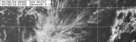
1. FORMATION OF A SIGNIFICANT TROPICAL CYCLONE IS POSSIBLE WITHIN
120 NM EITHER SIDE OF A LINE FROM 11.7N 104.5W TO 12.3N 109.9W
WITHIN THE NEXT 12 TO 24 HOURS. AVAILABLE DATA DOES NOT JUSTIFY
ISSUANCE OF NUMBERED TROPICAL CYCLONE WARNINGS AT THIS TIME.
WINDS IN THE AREA ARE ESTIMATED TO BE 18 TO 23 KNOTS. METSAT
IMAGERY AT 291200Z INDICATES THAT A CIRCULATION CENTER IS LOCATED
NEAR 12.0N 106.8W. THE SYSTEM IS MOVING WESTWARD AT 10 KNOTS.
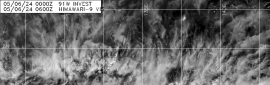
2. REMARKS: AN AREA OF CONVECTION HAS PERSISTED NEAR 12.0N 106.8W,
APPROXIMATELY 1368 NM SOUTH-SOUTHEAST OF SAN DIEGO, CALIFORNIA.
ANIMATED ENHANCED INFRARED SATELLITE IMAGERY (EIR) AND A 290838Z
AMSR-2 MICROWAVE IMAGE DEPICT WEAK CONVECTIVE BANDING OVER THE
NORTHERN SEMI-CIRCLE WRAPPING INTO A CONSLIDATING LOW LEVEL
CIRCULATION (LLC). EIR AND MICROWAVE IMAGERY ALSO REVEAL MOST OF THE
CONVECTION DISPLACED IN THE SOUTHERN SEMI-CIRCLE. UPPER-LEVEL
ANALYSIS INDICTATES A FAVORABLE ENVIRONMENT WITH LOW VERTICAL WIND
SHEAR (5-10KT), GOOD EQUATORWARD OUTFLOW, AND WARM SEA SURFACE
TEMPERATURES (29-30C). MAXIMUM SUSTAINED SURFACE WINDS ARE ESTIMATED
AT 18 TO 23 KNOTS. MINIMUM SEA LEVEL PRESSURE IS ESTIMATED TO BE
NEAR 1005 MB. THE POTENTIAL FOR THE DEVELOPMENT OF A SIGNIFICANT
TROPICAL CYCLONE WITHIN THE NEXT 24 HOURS IS HIGH.
3. THIS ALERT WILL BE REISSUED, UPGRADED TO WARNING OR CANCELLED BY
301330Z.
4. SEE REF A FOR DETAILS ON A TROPICAL CYCLONE FORMATION ALERT
LOCATED NEAR 13.8N 121.5W
//
NNNN
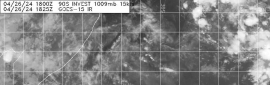
2. Satellite imagery indicates that a broad area of low pressure is
located several hundred miles offshore of the southwestern coast of
Mexico, and that the associated shower activity is showing signs
of organization. Environmental conditions are forecast to be
conducive for continued gradual development, and a tropical
depression is likely to form this weekend or early next week while
the system moves westward or west-northwestward at 10 to 15 mph.
* Formation chance through 48 hours...medium...40 percent.
* Formation chance through 5 days...high...70 percent.

.png")


.png")
.png")
.png")


.png")


.png")
.png")