開啟輔助訪問
 找回密碼
 立即加入

08E.Hilda 持續西行 逐漸減弱

簽到天數: 1650 天

[LV.Master]伴壇終老

2021-7-29 08:20 | 顯示全部樓層
  一級颶風  
編號:08 E
名稱:Hilda
085028m672lxwxwxfxw2fx.jpg
  基本資料  
擾動編號日期:2021 07 29 08
命名日期  :2021 07 31 02
撤編日期  :2021 08 06 20
登陸地點  :

  巔峰時期資料  
近中心最強風速 :75  kt ( Cat.1 )
海平面最低氣壓 :985 百帕

  擾動編號資料  
90E.INVEST.15kts.1009mb.9.5N.92W.

20210728.2330.goes-17.ir.90E.INVEST.15kts.1009mb.9.5N.92W.100pc.jpg
NHC:20%
2. Satellite imagery indicates that a broad area of low pressure has
formed several hundred miles offshore of the southwestern coast of
Mexico.  Environmental conditions are forecast to be conducive for
continued gradual development, and a tropical depression could form
this weekend or early next week while the system moves westward or
west-northwestward at 10 to 15 mph.
* Formation chance through 48 hours...low...20 percent.
* Formation chance through 5 days...medium...60 percent.
two_pac_2d2 (6).png two_pac_5d2 (5).png
以上資料來自:NHC、颱風論壇整理製作

評分

參與人數 1水氣能量 +15 +1 收起 理由
周子堯@FB + 15 + 1 熱帶擾動首帖

查看全部評分

回復

使用道具 舉報

簽到天數: 1650 天

[LV.Master]伴壇終老

老農民版夜神月|2021-8-7 01:22 | 顯示全部樓層
NHC停編08E 143708_5day_cone_no_line_and_wind.png 20210806.1630.goes-17.vis.2km.08E.HILDA.25kts.1008mb.22.9N.133.7W.pc.jpg
20210806.1550.f17.91pct91h91v.08E.HILDA.25kts.1008mb.22.9N.133.7W.095pc.jpg

000
WTPZ43 KNHC 061435
TCDEP3

Post-Tropical Cyclone Hilda Discussion Number  28
NWS National Hurricane Center Miami FL       EP082021
800 AM PDT Fri Aug 06 2021

Hilda has been devoid of organized deep convection for at least 12
hours, and since the cyclone is moving over sub-23C sea surface
temperatures, regeneration of deep convection is unlikely.  
Therefore, Hilda is designated as a 25 kt post-tropical remnant
low, and this is the last advisory from National Hurricane Center.  
The low should continue to move further into a dry and stable air
mass and over even cooler waters.  Consequently, weakening is
forecast and the remnant low of Hilda should open up into a trough
of low pressure over the weekend.

The initial motion is estimated to be west-northwestward, or 300/9
kt, and this general heading, within the low-level flow, is
forecast to continue until dissipation.

For additional information on Hilda please see High Seas Forecasts
issued by the National Weather service, under AWIPS header
NFDHSFEPI, WMO header FZPN02 KWBC, and on the web at
ocean.weather.gov/shtml/NFDHSFEPI.php


FORECAST POSITIONS AND MAX WINDS

INIT  06/1500Z 23.1N 134.1W   25 KT  30 MPH...POST-TROPICAL
12H  07/0000Z 23.6N 135.5W   25 KT  30 MPH...POST-TROP/REMNT LOW
24H  07/1200Z 24.1N 137.0W   20 KT  25 MPH...POST-TROP/REMNT LOW
36H  08/0000Z 24.5N 138.2W   20 KT  25 MPH...POST-TROP/REMNT LOW
48H  08/1200Z...DISSIPATED

$$
Forecaster Roberts

回復

使用道具 舉報

簽到天數: 1650 天

[LV.Master]伴壇終老

老農民版夜神月|2021-8-6 01:25 | 顯示全部樓層
NHC降格TD 143506_5day_cone_no_line_and_wind.png 20210805.1640.goes-17.vis.2km.08E.HILDA.30kts.1006mb.20.7N.129.7W.pc.jpg
20210805.1550.f17.ir.olsircomp.08E.HILDA.x.jpg

965
WTPZ43 KNHC 051434
TCDEP3

Tropical Depression Hilda Discussion Number  24
NWS National Hurricane Center Miami FL       EP082021
800 AM PDT Thu Aug 05 2021

After an earlier brief burst of thunderstorm activity northeast of
the center around 0600Z, associated convection since then has been
on a rapid decline and warming of the cloud tops which now barely
reach -30 deg C near the center. The initial intensity has been
lowered to 30 kt based on a blend of Dvorak T- and CI-numbers of
T2.5 and T1.5 from both TAFB and SAB, and an objective satellite
intensity estimate of 2.0/30 kt from UW-CIMSS ADT, making Hilda a
tropical depression. Further weakening is expected now that Hilda is
located over sub-23 deg C sea-surface temperatures and moving into a
drier and more stable air mass. The cyclone is forecast to
degenerate into a remnant low later today and open up into a trough
by the weekend, well east of the Hawaiian Islands.

The initial motion estimate is 305/11 kt, which is faster and a
little to the right of the previous advisory motion. This is likely
due to the low- and upper-level circulations having decoupled now,
owing to the lack of significant convection. The weakening cyclone
should be steered west-northwestward for the next 48 hours by a
sprawling subtropical ridge located to the north. The new NHC
forecast track is similar to the previous advisory track and lies
down the middle of the tightly packed consensus models.


FORECAST POSITIONS AND MAX WINDS

INIT  05/1500Z 21.0N 130.2W   30 KT  35 MPH
12H  06/0000Z 21.7N 131.8W   25 KT  30 MPH
24H  06/1200Z 22.5N 133.9W   25 KT  30 MPH...POST-TROP/REMNT LOW
36H  07/0000Z 23.2N 136.1W   20 KT  25 MPH...POST-TROP/REMNT LOW
48H  07/1200Z 23.9N 138.3W   15 KT  15 MPH...POST-TROP/REMNT LOW
60H  08/0000Z...DISSIPATED

$$
Forecaster Stewart

回復

使用道具 舉報

簽到天數: 1650 天

[LV.Master]伴壇終老

老農民版夜神月|2021-8-5 05:02 | 顯示全部樓層
即將減弱為TD 203532_5day_cone_no_line_and_wind.png

000
WTPZ43 KNHC 042034
TCDEP3

Tropical Storm Hilda Discussion Number  21
NWS National Hurricane Center Miami FL       EP082021
200 PM PDT Wed Aug 04 2021

Convection associated with Hilda continues to weaken and shrink in
areal coverage due to modest northwesterly vertical wind shear,
sub-25C sea-surface temperatures (SSTs), and entrainment of stable,
cold-air stratocumulus clouds. A 1656Z partial ASCAT-A scatterometer
pass revealed two 33-kt vectors in the southeastern quadrant in the
radius-of-maximum winds. Even allowing for some undersampling, this
indicates that Hilda is barely hanging on to tropical storm status,
and the initial intensity will remain at 35 kt for this advisory.

Model analyses show virtually no instability in the center of and
north of Hilda right now, and with the cyclone forecast to move over
even cooler water and into increasing westerly wind shear during the
next 12-24 hours, a rapid decrease in both the convection and
cyclone's intensity appears to be forthcoming soon. Hilda is
forecast to become a depression later tonight and a remnant low
on Thursday. Dissipation is expected by late Friday or Saturday
well to the east of the Hawaiian Islands. The latest NHC official
intensity forecast is similar to the previous advisory, and follows
a blend of the HCCA and IVCN consensus intensity models.

Hilda continues on a steady west-northwestward course or 295/08 kt.
This general motion is expected to continue into  Thursday,
followed by a more westward motion on Friday and Saturday as a low-
to mid-level ridge builds to north of Hilda on days 2 and 3. The
official NHC track forecast is essentially just an update of
the previous advisory track, and lies along the southern edge of
the guidance envelope between the tightly packed consensus track
models to the north and the ECMWF model to the south.


FORECAST POSITIONS AND MAX WINDS

INIT  04/2100Z 19.4N 128.0W   35 KT  40 MPH
12H  05/0600Z 20.0N 129.4W   30 KT  35 MPH
24H  05/1800Z 21.0N 131.4W   25 KT  30 MPH
36H  06/0600Z 21.8N 133.7W   25 KT  30 MPH...POST-TROP/REMNT LOW
48H  06/1800Z 22.4N 136.1W   20 KT  25 MPH...POST-TROP/REMNT LOW
60H  07/0600Z 23.0N 138.4W   20 KT  25 MPH...POST-TROP/REMNT LOW
72H  07/1800Z...DISSIPATED

$$
Forecaster Stewart
20210804.1640.goes-17.vis.2km.08E.HILDA.35kts.1005mb.18.9N.127W.pc.jpg GOES20502021216EzgePu.jpg
回復

使用道具 舉報

簽到天數: 1650 天

[LV.Master]伴壇終老

老農民版夜神月|2021-8-1 08:50 | 顯示全部樓層
00Z升格C1,定強75KT
20210801.0000.goes-17.ir.08E.HILDA.75kts.985mb.14.2N.118.3W.100pc.jpg 20210731.2055.gw1.89hbt.08E.HILDA.60kts.994mb.14N.117.4W.73pc.jpg
20210731.2055.gw1.89pct89h89v.08E.HILDA.60kts.994mb.14N.117.4W.73pc.jpg
回復

使用道具 舉報

簽到天數: 3279 天

[LV.Master]伴壇終老

t02436|2021-8-1 00:28 | 顯示全部樓層
底層風眼構建中,15Z強度已提升至TS上限的60節,巔峰上望85節。
029
WTPZ43 KNHC 311449
TCDEP3

Tropical Storm Hilda Discussion Number   4
NWS National Hurricane Center Miami FL       EP082021
800 AM PDT Sat Jul 31 2021

Hilda is strengthening quickly this morning.  Satellite images show
an eye feature trying to form, and convection has deepened and
become increasingly symmetric around the center.  The latest Dvorak
estimates supported raising the initial intensity to 55 kt at 12Z,
and since Hilda continues to organize, the initial intensity is set
a little higher at 60 kt for this advisory.  This makes Hilda just
below hurricane strength.

The current favorable environmental conditions of low wind shear,
high amounts of moisture, and warm SSTs should continue to allow
Hilda to intensify during the next day or so.  In addition, given
that Hilda now has a tight inner core, rapid intensification (RI) is
a decent possibility, and the SHIPS RI index now shows a 30 percent
chance of that occurring during the next 24 hours.  In a couple of
days, however, decreasing moisture and progressively cooler SSTs
should end the strengthening trend and gradually cause weakening
during the remainder of the forecast period.  The NHC intensity
forecast is above than the previous one in the short term and it
lies at the high end of the model guidance.  The long term forecast
is largely similar to the previous one and lies near the middle of
the guidance envelope.

Hilda is moving west-northwestward at 11 kt.  A subtropical ridge
should keep the storm on a general west-northwest heading during the
next several days, but there could be some interaction with Tropical
Depression Nine-E to the west and a low pressure area to the east
that could cause slow downs and wobbles in the future track.  There
is a fair amount of spread among the models, especially at the
longer range forecast times, but the latest consensus models are
right on top of the previous track. Therefore, the NHC track
forecast is largely just an update of the previous one.


FORECAST POSITIONS AND MAX WINDS

INIT  31/1500Z 13.7N 116.7W   60 KT  70 MPH
12H  01/0000Z 14.0N 118.2W   70 KT  80 MPH
24H  01/1200Z 14.4N 119.9W   85 KT 100 MPH
36H  02/0000Z 15.0N 121.5W   85 KT 100 MPH
48H  02/1200Z 15.5N 122.9W   85 KT 100 MPH
60H  03/0000Z 16.1N 124.3W   80 KT  90 MPH
72H  03/1200Z 16.9N 125.7W   70 KT  80 MPH
96H  04/1200Z 18.5N 128.6W   55 KT  65 MPH
120H  05/1200Z 19.3N 132.6W   45 KT  50 MPH

$$
Forecaster Cangialosi

145044_5day_cone_with_line.png
20210731.1232.f15.85rgb.08E.HILDA.55kts.997mb.13.6N.116.2W.060pc.jpg
GOES16102021212TaBdXY.jpg
goes17_rainbow_08E.gif
回復

使用道具 舉報

簽到天數: 1650 天

[LV.Master]伴壇終老

老農民版夜神月|2021-7-31 05:39 | 顯示全部樓層
本帖最後由 老農民版夜神月 於 2021-7-31 05:40 編輯

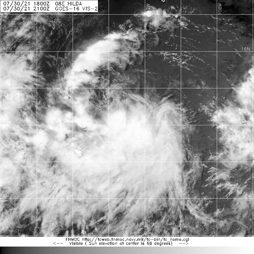
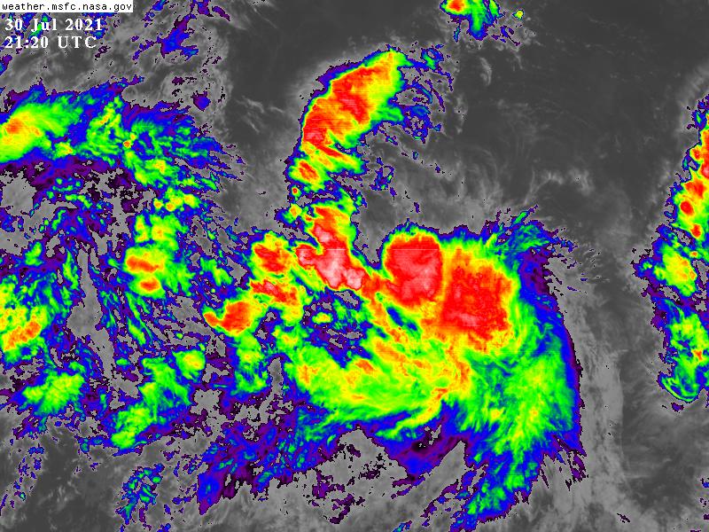
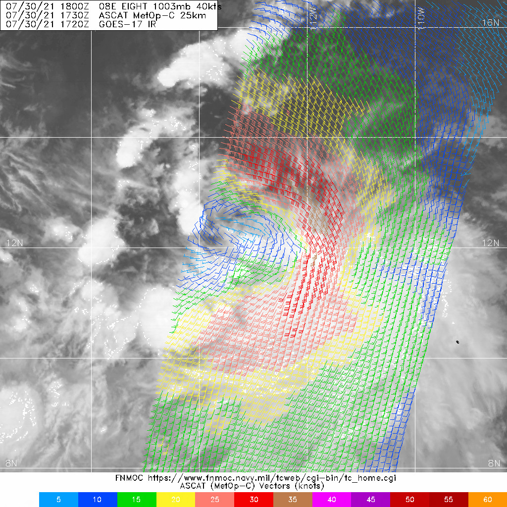
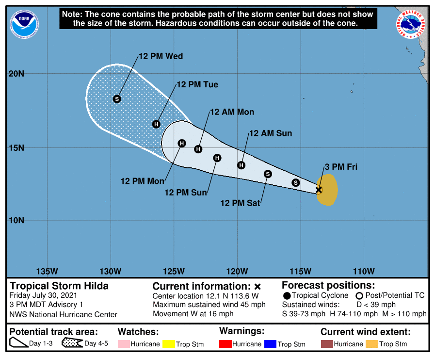
NHC直接升格TS,並命名Hilda,初報上望75節 203911_5day_cone_no_line_and_wind.png 20210730.2100.goes-16.vis.2km.08E.HILDA.40kts.1003mb.11.9N.113W.pc.jpg
GOES21202021211TQbkq5.jpg 20210730.1730.mtc.ASCAT.wind.08E.EIGHT.40kts-1003mb.119N.1130W.25km.noqc.jpeg
000
WTPZ43 KNHC 302036
TCDEP3

Tropical Storm Hilda Discussion Number   1
NWS National Hurricane Center Miami FL       EP082021
300 PM MDT Fri Jul 30 2021

A pair of ASCAT passes from a few hours ago indicated that the area
of low pressure located about 800 miles south-southwest of the
southern tip of the Baja California peninsula has strengthened, and
is producing 35-40 kt winds on its east side.  In addition,
satellite images show a fairly persistent area of showers and
thunderstorms on the south side of the circulation and the center
appears to be fairly well defined in recent visible images.  Based
on these data, advisories are now being initiated on Tropical Storm
Hilda and the initial intensity is estimated to be 40 kt.

Hilda is moving westward at about 14 kt and is embedded in the flow
on the south side of a sprawling subtropical ridge that extends from
the south-central U.S. westward across the subtropical eastern
Pacific.  A general west-northwestward motion at about the same
forward speed is expected during the next day or two as the synoptic
pattern holds.  After that time, a decrease in forward speed is
predicted due to a combination of the subtropical ridge weakening
and the interactions with the areas of low pressure to the east and
west of Hilda.  The ECMWF is the slowest model at long range due to
it showing the most interaction with the low to Hildas east.  The
NHC track forecast lies generally near the model consensus and
roughly between the GFS and ECMWF models.

Hilda appears to be in generally conducive conditions for
strengthening with SSTs currently around 28 C, abundant mid-level
moisture, and fairly low wind shear. Given that these conditions are
expected to persist for another couple of days, steady strengthening
is forecast during that time period and Hilda is predicted to become
a hurricane in 24 to 36 hours.  Beyond a couple of days, however,
moderate easterly shear, progressively drier air, and decreasing
SSTs should end the strengthening trend and induce gradual weakening
of the cyclone.  The NHC intensity forecast lies near the middle of
the guidance envelope, closest to the intensity model consensus
IVCN.


FORECAST POSITIONS AND MAX WINDS

INIT  30/2100Z 12.1N 113.6W   40 KT  45 MPH
12H  31/0600Z 12.6N 115.4W   50 KT  60 MPH
24H  31/1800Z 13.2N 117.6W   60 KT  70 MPH
36H  01/0600Z 13.8N 119.7W   70 KT  80 MPH
48H  01/1800Z 14.3N 121.6W   75 KT  85 MPH
60H  02/0600Z 14.9N 123.1W   75 KT  85 MPH
72H  02/1800Z 15.3N 124.4W   70 KT  80 MPH
96H  03/1800Z 16.6N 126.4W   65 KT  75 MPH
120H  04/1800Z 18.3N 129.5W   55 KT  65 MPH

$$
Forecaster Cangialosi

回復

使用道具 舉報

12下一頁
快速回覆
您需要登錄後才可以回帖 登錄 | 立即加入

本版積分規則

本平台僅供學術討論之用,預報應以氣象局為準

威普網站虛擬主機贊助公司

臺灣第一個天氣類型社群平台 即時天氣資訊、精準颱風動態

線上客服
FB傳送訊息
廣告行銷
精準行銷 物超所值
官方粉專
發佈 快速回復 返回頂部 返回列表