開啟輔助訪問
 找回密碼
 立即加入

05L.Elsa 登陸美國佛州 轉化溫氣

簽到天數: 483 天

[LV.9]以壇為家II

2021-6-29 20:32 來自手機 | 顯示全部樓層
  一級颶風  
編號:05 L
名稱:Elsa
081340vyy9yir93aaoe29e.jpg
  基本資料  
擾動編號日期:2021 06 29 20
命名日期  :2021 07 01 14
撤編日期  :2021 07 10 19
登陸地點  :古巴
                          
                       美國-佛羅里達州

  巔峰時期資料  
近中心最強風速 :75  kt ( Cat.1 )
海平面最低氣壓 :991 百帕

  擾動編號資料  
97L.INVEST.20kts.1000mb.8N.34.4W

A493490E-0C9A-4C3B-A0B8-0B7CC3A1104E.jpeg
  NHC:10%  
2. Shower activity associated with a tropical wave located about 800
miles southwest of the Cabo Verde islands has become a little
better organized since yesterday.  Additional slow development of
this system is possible during the next several days as it moves
generally west-northwestward at about 20 mph.
* Formation chance through 48 hours...low...10 percent.
* Formation chance through 5 days...low...20 percent.
1303C9AA-A738-424C-84EC-BAE8A43D4DB3.png
以上資料來自:NHC、颱風論壇整理製作

評分

參與人數 1水氣能量 +15 +1 收起 理由
king111807 + 15 + 1 熱帶擾動首帖

查看全部評分

回復

使用道具 舉報

簽到天數: 1650 天

[LV.Master]伴壇終老

老農民版夜神月|2021-7-10 05:08 | 顯示全部樓層
本帖最後由 老農民版夜神月 於 2021-7-10 05:27 編輯

NHC21Z報判定Elsa已轉溫
637
WTNT45 KNHC 092042
TCDAT5

Post-Tropical Cyclone Elsa Discussion Number  39
NWS National Hurricane Center Miami FL       AL052021
500 PM AST Fri Jul 09 2021

Surface, satellite, and radar data indicate that Elsa's deep
convection remains limited to a shield north of its center and that
a front extends through the center of the cyclone. For those
reasons, Elsa was designated as a post-tropical cyclone at 1800 UTC.
Surface observations of sustained winds a little above 40 kt were
reported across portions of southern Massachusetts and the nearby
waters as Elsa crossed the state, so the intensity estimate remains
45 kt.

Elsa is moving quickly just off the northeast coast of the U.S. with
an initial motion estimate of 040/27 kt. A faster northeastward
motion is expected tonight and on Saturday while the system remains
embedded within a deep mid-latitude trough. Very little change was
made to the NHC track forecast. All available guidance indicates
that Elsa will gradually weaken during the next couple of days. The
GFS, ECMWF, and CMC global models now indicate the cyclone will open
into a trough within the next 48 h or so, and this is reflected in
the NHC forecast.

It is estimated that center of Elsa made landfall along the coast of
Long Island near Southampton around 1430 UTC (10:30 am EDT), and
again near Watch Hill, Rhode Island near 1615 UTC (12:15 pm EDT).
Elsa's classification at the time the center crossed the coast will
be determined in the post-storm analysis. It should also be noted
that the landfall position had little bearing on the location or
timing of the strong winds and heavy rain which were well removed
from the cyclone's center.

Since Elsa is now post-tropical and all coastal tropical storm
warnings have been discontinued, this is the last NHC advisory.  
Additional information on this system can be found in High Seas
Forecasts issued by the National Weather Service, under AWIPS
header NFDHSFAT1, WMO header FZNT01 KWBC, and online at
ocean.weather.gov/shtml/NFDHSFAT1.php


Key Messages:

1. As Elsa moves off the coast of Maine through this evening, heavy
rainfall could lead to considerable flash and urban flooding.

2. Gusty winds will continue across portions of the southern New
England coast during the next couple of hours. The post-tropical
cyclone is also expected to bring gusty winds to portions of
Atlantic Canada tonight and Saturday.


FORECAST POSITIONS AND MAX WINDS

INIT  09/2100Z 43.0N  69.5W   45 KT  50 MPH...POST-TROPICAL
12H  10/0600Z 46.2N  64.7W   40 KT  45 MPH...POST-TROP/EXTRATROP
24H  10/1800Z 50.3N  56.1W   40 KT  45 MPH...POST-TROP/EXTRATROP
36H  11/0600Z 54.7N  46.0W   35 KT  40 MPH...POST-TROP/EXTRATROP
48H  11/1800Z...DISSIPATED

$$
Forecaster Zelinsky

204316_5day_cone_no_line_and_wind.png al052021 (17).gif sfcplot_05L_latest (1).png
20211902040_GOES16-ABI-FL-GEOCOLOR-AL052021-1000x1000.jpg GOES2050202119009IAfW.jpg
回復

使用道具 舉報

簽到天數: 1650 天

[LV.Master]伴壇終老

老農民版夜神月|2021-7-9 23:06 | 顯示全部樓層
NHC預測12H內即將轉化
000
WTNT45 KNHC 091446
TCDAT5

Tropical Storm Elsa Discussion Number  38
NWS National Hurricane Center Miami FL       AL052021
1100 AM EDT Fri Jul 09 2021

The extratropical transition of Elsa is well underway.  A frontal
boundary located over southern New England nearly wraps into the
circulation center, and the primary area of cold cloud tops and
heavy rainfall has now shifted to the northwestern portion of the
cyclone.  Elsa is expected to complete its extratropical transition
this afternoon.  Buoy and surface observations indicate that the
cyclone's intensity has changed little since early this morning.
Based on those data, Elsa's peak winds and minimum pressure
remain 45 kt and 1000 mb for this advisory, respectively.

Elsa continues to move quickly northeastward or 045/27 kt.  The
post-tropical cyclone is forecast to continue accelerating
northeastward over the next day or two as it remains embedded
within deep-layer southwesterly flow.  After 48 hours, the system is
expected to slow before it dissipates over the north Atlantic
around day 3.  The track guidance remains in good agreement, but has
shifted slightly southward after 24 hours and the NHC forecast has
been adjusted accordingly.

Little change in strength is anticipated in the short-term as Elsa
completes its extratropical transition.  After that time, gradual
weakening is anticipated and the wind speed forecast calls for the
system to weaken below gale-force in a couple of days.  The global
models show the post-tropical cyclone dissipating over the north
Atlantic by early next week, and the official forecast follows
suit.

Key Messages:

1. As Elsa moves near southern and coastal New England today, heavy
rainfall could lead to considerable flash and urban flooding.

2. Tropical storm conditions are expected to continue in portions
of the warning area in Long Island and southern New England
through this afternoon. Gusty winds are expected over portions of
Atlantic Canada tonight and Saturday.


FORECAST POSITIONS AND MAX WINDS

INIT  09/1500Z 41.0N  72.1W   45 KT  50 MPH
12H  10/0000Z 44.0N  67.7W   45 KT  50 MPH...POST-TROP/EXTRATROP
24H  10/1200Z 48.4N  60.3W   40 KT  45 MPH...POST-TROP/EXTRATROP
36H  11/0000Z 52.2N  51.0W   35 KT  40 MPH...POST-TROP/EXTRATROP
48H  11/1200Z 56.5N  41.0W   30 KT  35 MPH...POST-TROP/EXTRATROP
60H  12/0000Z 60.0N  32.5W   30 KT  35 MPH...POST-TROP/EXTRATROP
72H  12/1200Z...DISSIPATED

$$
Forecaster Brown
144708_5day_cone_no_line_and_wind.png 20211901440_GOES16-ABI-FL-GEOCOLOR-AL052021-1000x1000.jpg
GOES15012021190TWScaL.jpg
回復

使用道具 舉報

簽到天數: 483 天

[LV.9]以壇為家II

dom|2021-7-9 16:48 | 顯示全部樓層
NHC09Z判定出海
000
WTNT45 KNHC 090844
TCDAT5

Tropical Storm Elsa Discussion Number  37
NWS National Hurricane Center Miami FL       AL052021
500 AM EDT Fri Jul 09 2021

Elsa has become better organized this early Friday morning as
evidenced by a tightly coiled convective band that wraps completely
around the low-level circulation center, along with Doppler radar
velocities of more than 80 kt detected between 3000-7000 ft.
Upper-level outflow has expanded in all directions except the
southwestern quadrant, and the GFS and ECMWF models have assessed
the vertical wind shear to only be 10 kt and 13 kt, respectively,
over the center. Wind gusts to 68 kt and 62 kt were recently
measured in Ludlam Bay, New Jersey, and Beach Haven, New Jersey,
respectively. However, radar data suggest that these wind gusts were
possibly associated with the passage of nearby tornadic circulations
and were not due to Elsa's larger wind field. The central pressure
of 1000 mb is based on a nearby pressure report of 1000.6 mb from
the Ludlam Bay, New Jersey, WeatherFlow site, but this value could
be conservative. The initial wind speed remains 45 kt based on
recent observations from offshore buoys.

The initial motion is estimated to be 045/27 kt. Elsa is forecast
by the latest global and regional models to continue accelerating
northeastward today through Saturday due to the system being
embedded within deep-layer southwesterly mid-latitude flow. Elsa
should move over southeastern New England today and over Atlantic
Canada late tonight and on Saturday. The new NHC track forecast lies
on top of the previous advisory track and is close to the middle of
the tightly packed simple- and corrected-consensus track models.

Elsa will be moving over 22-deg-C and cooler sea-surface
temperatures by 6 hours and beyond, which should further hasten
the ongoing extratropical transition process. This transition is
expected to be completed in 18 hours or so when Elsa is forecast to
be located over Atlantic Canada.

Key Messages:

1. As Elsa moves near Long Island and southern and coastal New
England today, heavy rainfall could lead to considerable flash
and urban flooding.

2. Tropical storm conditions should continue along portions of the
mid-Atlantic coast early this morning. Tropical storm conditions
are expected in portions of the southern New England states and New
York by late this morning and afternoon.  Gusty winds are expected
over portions of Atlantic Canada tonight and Saturday.


FORECAST POSITIONS AND MAX WINDS

INIT  09/0900Z 39.4N  74.3W   45 KT  50 MPH...OVER WATER
12H  09/1800Z 42.2N  70.3W   45 KT  50 MPH...OVER WATER
24H  10/0600Z 46.6N  63.4W   45 KT  50 MPH...POST-TROP/EXTRATROP
36H  10/1800Z 51.3N  54.5W   40 KT  45 MPH...POST-TROP/EXTRATROP
48H  11/0600Z 55.4N  45.2W   35 KT  40 MPH...POST-TROP/EXTRATROP
60H  11/1800Z 59.5N  36.0W   30 KT  35 MPH...POST-TROP/EXTRATROP
72H  12/0600Z...DISSIPATED

$$
Forecaster Stewart
083836_5day_cone_no_line_and_wind.png
回復

使用道具 舉報

簽到天數: 1650 天

[LV.Master]伴壇終老

老農民版夜神月|2021-7-9 05:22 | 顯示全部樓層
本帖最後由 老農民版夜神月 於 2021-7-9 05:39 編輯

正沿美國東岸北上,將逐漸轉化為溫帶氣旋
000
WTNT45 KNHC 082056
TCDAT5

Tropical Storm Elsa Discussion Number  35
NWS National Hurricane Center Miami FL       AL052021
500 PM EDT Thu Jul 08 2021

A NOAA NOS observing site at Wrightsville Beach, North Carolina,
recently reported a sustained wind of 41 kt, so Elsa's maximum winds
are now estimated to be 45 kt.  A number of other observing sites in
the vicinity have also reported sustained tropical-storm-force
winds.  Elsa's slight strengthening may be the result of baroclinic
forcing associated with an approaching short-wave trough. The
system's cloud tops have warmed somewhat during the day, but it is
still producing some very heavy rains.

Elsa's low-level center is a bit elongated from southwest to
northeast, but surface synoptic data indicate that it has moved into
northern North Carolina.  The storm continues to gradually
accelerate toward the northeast, and the initial motion estimate is
040/18 kt.  A faster northeastward motion is expected over the next
1-2 days as the cyclone moves along with the mid-latitude
southwesterly flow ahead of a broad mid-tropospheric trough over the
eastern United States and Canada.  Elsa should move near or
over southeastern New England and Atlantic Canada within the next
24-48 hours.  The official track forecast remains close to the
previous one and similar to the multi-model consensus, TVCA.

The global models suggest that not much additional strengthening is
likely.  Simulated satellite imagery from these models show an
extratropical appearance in 24-36 hours so the official forecast
shows an extratropical transition by late Friday.  This is also
supported by cyclone phase analyses of the model fields from
Florida State University.


Key Messages:

1.As Elsa moves from North Carolina to Virginia today and this
evening, heavy rainfall may result in limited flash and urban
flooding. Heavy rainfall from the Mid-Atlantic into New England
through Friday could lead to considerable flash and urban flooding.

2. Tropical storm conditions should continue along portions of the
North Carolina coast this afternoon and spread over the
mid-Atlantic coast later today or tonight.  Tropical storm
conditions are expected in portions of the southern New England
states and New York by Friday.  Gusty winds are expected over
portions of Atlantic Canada Friday night and Saturday.


FORECAST POSITIONS AND MAX WINDS

INIT  08/2100Z 36.3N  78.3W   45 KT  50 MPH...INLAND
12H  09/0600Z 38.7N  75.1W   45 KT  50 MPH...INLAND
24H  09/1800Z 42.5N  70.0W   45 KT  50 MPH...OVER WATER
36H  10/0600Z 47.0N  63.0W   45 KT  50 MPH...POST-TROP/EXTRATROP
48H  10/1800Z 51.5N  54.5W   40 KT  45 MPH...POST-TROP/EXTRATROP
60H  11/0600Z 56.0N  45.0W   35 KT  40 MPH...POST-TROP/EXTRATROP
72H  11/1800Z...DISSIPATED

$$
Forecaster Pasch

205739_5day_cone_no_line_and_wind.png al052021 (15).gif
sfcplot_05L_latest.png 20211892050_GOES16-ABI-FL-GEOCOLOR-AL052021-1000x1000.jpg
回復

使用道具 舉報

簽到天數: 1650 天

[LV.Master]伴壇終老

老農民版夜神月|2021-7-8 02:21 | 顯示全部樓層
本帖最後由 老農民版夜神月 於 2021-7-8 05:45 編輯

於17Z前後已登錄佛州
TXNT28 KNES 071742
TCSNTL

A.  05L (ELSA)

B.  07/1730Z

C.  30.3N

D.  83.5W

E.  THREE/GOES-E

F.  OVERLAND

G.  IR/EIR/VIS

H.  REMARKS...THE SYSTEM'S LLCC HAS NOW PROGRESSED OVERLAND. THIS WILL
BE THE FINAL BULLETIN UNLESS THE SYSTEM REEMERGES BACK OVER THE WATER
AS A TROPICAL SYSTEM IN SATELLITE IMAGERY.

I.  ADDL POSITIONS

    NIL


...SAMBUCCI

175407_5day_cone_no_line_and_wind.png 20211881740_GOES16-ABI-FL-GEOCOLOR-AL052021-1000x1000.jpg
000
WTNT35 KNHC 071753
TCPAT5

BULLETIN
Tropical Storm Elsa Intermediate Advisory Number 30A
NWS National Hurricane Center Miami FL       AL052021
200 PM EDT Wed Jul 07 2021

...ELSA INLAND AND WEAKENING OVER NORTHERN FLORIDA...


SUMMARY OF 200 PM EDT...1800 UTC...INFORMATION
----------------------------------------------
LOCATION...30.3N 83.5W
ABOUT 105 MI...170 KM W OF JACKSONVILLE FLORIDA
MAXIMUM SUSTAINED WINDS...50 MPH...85 KM/H
PRESENT MOVEMENT...N OR 360 DEGREES AT 14 MPH...22 KM/H
MINIMUM CENTRAL PRESSURE...1002 MB...29.59 INCHES


WATCHES AND WARNINGS
--------------------
CHANGES WITH THIS ADVISORY:

All warnings have been discontinued south of the Suwannee River,
Florida.

SUMMARY OF WATCHES AND WARNINGS IN EFFECT:

A Storm Surge Warning is in effect for...
* West coast of Florida from the Suwannee River to the Aucilla River

A Tropical Storm Warning is in effect for...
* West coast of Florida from the Suwannee River to the Ochlockonee
River
* Mouth of St. Marys River, Georgia to Little River Inlet, South
Carolina

A Tropical Storm Watch is in effect for...
* North of Little River Inlet, South Carolina to Sandy Hook, New
Jersey
* Pamlico and Albemarle Sounds
* Chesapeake Bay south of North Beach and the tidal Potomac south
of Cobb Island
* Delaware Bay south of Slaughter Beach

A Storm Surge Warning means there is a danger of life-threatening
inundation, from rising water moving inland from the coastline,
in the indicated locations. For a depiction of areas at risk,
please see the National Weather Service Storm Surge Watch/Warning
Graphic, available at hurricanes.gov.

A Tropical Storm Warning means that tropical storm conditions are
expected somewhere within the warning area.

A Tropical Storm Watch means that tropical storm conditions are
possible within the watch area.

Interests in southeastern New England and the Canadian Maritimes
should monitor the progress of Elsa.

For storm information specific to your area, including possible
inland watches and warnings, please monitor products issued by your
local National Weather Service forecast office.


DISCUSSION AND OUTLOOK
----------------------
At 200 PM EDT (1800 UTC), the center of Tropical Storm Elsa was
located near latitude 30.3 North, longitude 83.5 West.  Elsa is
moving toward the north near 14 mph (22 km/h).  A turn toward
the north-northeast is expected this evening, followed by a faster
northeastward motion by late Thursday.  On the forecast track, Elsa
will move over Georgia tonight, over South Carolina early on
Thursday, over North Carolina later on Thursday, and move near or
over the mid-Atlantic coast on Friday.

Maximum sustained winds have decreased to near 50 mph (85 km/h)
with higher gusts.  Continued weakening is expected through
tomorrow as Elsa moves over land.

Tropical-storm-force winds extend outward up to 70 miles (110 km)
from the center.

The estimated minimum central pressure is 1002 mb (29.59 inches).


HAZARDS AFFECTING LAND
----------------------
Key messages for Elsa can be found in the Tropical Cyclone
Discussion under AWIPS header MIATCDAT5, WMO header WTNT45 KNHC and
on the web at
www.hurricanes.gov/graphics_at5.shtml?key_messages.

WIND: Tropical storm conditions will continue along the Gulf coast
of Florida in the warning area today.  Tropical storm conditions are
expected in the Tropical Storm Warning area along the Georgia coast
by late today or tonight and along the South Carolina coast tonight
and early Thursday.  Tropical storm conditions are possible in the
watch area in the mid-Atlantic and northeastern states by Thursday
night and Friday.

STORM SURGE: The combination of a storm surge and the tide will
cause normally dry areas near the coast to be flooded by rising
waters moving inland from the shoreline.  The water could reach the
following heights above ground somewhere in the indicated areas if
the peak surge occurs at the time of high tide...

Suwannee River to Aucilla River...2 to 4 ft
Middle of Longboat Key, FL to Suwannee River including Tampa Bay...1
to 3 ft
Aucilla River to Ochlockonee River...1 to 3 ft
Mouth of St. Marys River to South Santee River...1 to 2 ft

Surge-related flooding depends on the relative timing of the surge
and the tidal cycle, and can vary greatly over short distances.  For
information specific to your area, please see products issued by
your local National Weather Service forecast office.

RAINFALL: Elsa is expected to produce the following rainfall amounts
and impacts the rest of this week:

Across western and northern portions of the Florida Peninsula...3
to 6 inches with localized maximum storm totals up to 9 inches
today, which may result in considerable flash and urban flooding,
along with minor to isolated moderate river flooding.

Across portions of southeast Georgia and the Lowcountry of South
Carolina, 2 to 4 inches with isolated maximum totals up to 6 inches
will be possible, which may result in considerable flash and urban
flooding.

Across eastern North Carolina into southeastern Virginia...1 to 3
inches with isolated totals up to 5 inches tonight through Thursday
night, which could lead to isolated flash and urban flooding.

Across the Northeast and New England, 1 to 3 inches with isolated
totals up to 5 inches Thursday into Friday will be possible. This
could lead to isolated flash and urban flooding.

TORNADOES: A few tornadoes are possible today and tonight across
northern Florida and southeastern Georgia into eastern South
Carolina.  The tornado threat should shift to the eastern Carolinas
and far southeast Virginia on Thursday.

SURF: Swells will continue to affect portions of the west coast of
Florida through today.  These swells are likely to cause
life-threatening surf and rip current conditions.  Please consult
products from your local weather office for more details.


NEXT ADVISORY
-------------
Next complete advisory at 500 PM EDT.

$$
Forecaster Pasch/Papin/Brown

al052021 (12).gif 20210707.1800.goes-16.vis.2km.05L.ELSA.55kts.999mb.29.2N.83.6W.pc.jpg
GOES18162021188gZAzFv.jpg
回復

使用道具 舉報

簽到天數: 483 天

[LV.9]以壇為家II

dom|2021-7-7 18:52 | 顯示全部樓層
NHC預測即將登陸佛州
712
WTNT45 KNHC 070906
TCDAT5

Tropical Storm Elsa Discussion Number  29
NWS National Hurricane Center Miami FL       AL052021
500 AM EDT Wed Jul 07 2021

The central convection associated with Elsa dissipated for a time
earlier this morning, although the latest radar and satellite
imagery shows a new band forming in the northern semicircle.  This
decrease was likely caused by a combination of shear and dry air
entrainment, and it has caused the cyclone to weaken.  Aircraft and
surface observations indicate the central pressure has risen to
near 1004 mb, and the initial intensity is decreased to a possibly
generous 55 kt based on aircraft and Doppler radar data.

After a slight jog to the left, the storm has resumed a motion of
360/12. This motion should continue for the next 12 h or so until
landfall occurs across the northwestern Florida peninsula.
Thereafter, a gradual turn toward the north-northeast is expected
by, followed by acceleration toward the northeast as Elsa moves
into the mid-latitude westerlies.  The forecast guidance has
shifted a little to the left since the last advisory, and the new
forecast track is also nudged in that direction.  The new track
lies a little to the right of the various consensus models.

While little change in strength is forecast before landfall, there
is a chance that the new convection could cause a short-lived
re-intensification.  So, based on this possibility a hurricane
warning remains in effect for portions of the west coast of
Florida.  After landfall, Elsa should weaken as it crosses the
southeastern United States, followed by some re-intensification as
it accelerates back over the Atlantic.  The system is expected to
become extratropical by the time it reaches the Canadian Maritimes
in 72 h.  The new intensity forecast is at the upper edge of the
guidance envelope and has only minor adjustments from the previous
forecast.


Key Messages:

1. As Elsa moves across the western and northern Florida Peninsula
today, heavy rainfall may result in considerable flash, urban, and
isolated moderate river flooding.  Heavy rainfall across southeast
Georgia, South Carolina, North Carolina, and southeastern Virginia
may result in isolated flash and urban flooding, with considerable
flash and urban flooding possible across coastal Georgia and the
Lowcountry of South Carolina. Heavy rainfall across the Northeast
and New England Thursday and Friday could lead to isolated flash and
urban flooding.

2. There is a danger of life-threatening storm surge along portions
of the west coast of Florida today, and a Storm Surge Warning is in
effect for that area.

3. Hurricane conditions are possible during the next several
hours along a portion of the west coast of Florida, where a
Hurricane Warning is in effect.  Tropical storm conditions are
occurring across portions of the western Florida peninsula and will
continue to spread northward along the west coast of the state
within the warning area through today.

4. Although the center of Elsa is expected to remain inland of the
coastline from Georgia through the Carolinas during the next day
or two, tropical storm conditions are expected along much of the
coasts of Georgia and South Carolina.  Tropical storm conditions
are also possible along the coast of the mid-Atlantic state by
Thursday night or Friday.


FORECAST POSITIONS AND MAX WINDS

INIT  07/0900Z 28.5N  83.5W   55 KT  65 MPH
12H  07/1800Z 30.2N  83.3W   50 KT  60 MPH
24H  08/0600Z 32.6N  82.0W   40 KT  45 MPH...INLAND
36H  08/1800Z 35.3N  79.4W   35 KT  40 MPH...INLAND
48H  09/0600Z 38.1N  75.6W   40 KT  45 MPH...INLAND
60H  09/1800Z 41.5N  70.9W   45 KT  50 MPH...OVER WATER
72H  10/0600Z 45.6N  64.6W   45 KT  50 MPH...POST-TROP/EXTRATROP
96H  11/0600Z 54.0N  50.0W   45 KT  50 MPH...POST-TROP/EXTRATROP
120H  12/0600Z...DISSIPATED

$$
Forecaster Beven
085826_5day_cone_no_line_and_wind.png
回復

使用道具 舉報

簽到天數: 483 天

[LV.9]以壇為家II

dom|2021-7-7 14:13 | 顯示全部樓層
NHC06Z降格TS
980
WTNT35 KNHC 070548
TCPAT5

BULLETIN
Tropical Storm Elsa Intermediate Advisory Number 28A
NWS National Hurricane Center Miami FL       AL052021
200 AM EDT Wed Jul 07 2021

...ELSA WEAKENS TO A TROPICAL STORM...
...HEAVY RAINS AND GUSTY WINDS CONTINUE SPREADING INLAND ACROSS
SOUTHWEST AND WEST-CENTRAL FLORIDA...


SUMMARY OF 200 AM EDT...0600 UTC...INFORMATION
----------------------------------------------
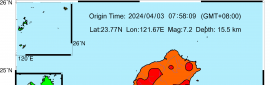
LOCATION...27.9N 83.5W
ABOUT 60 MI...95 KM W OF TAMPA FLORIDA
ABOUT 90 MI...145 KM SSW OF CEDAR KEY FLORIDA
MAXIMUM SUSTAINED WINDS...70 MPH...115 KM/H
PRESENT MOVEMENT...N OR 350 DEGREES AT 14 MPH...22 KM/H
MINIMUM CENTRAL PRESSURE...1004 MB...29.65 INCHES


WATCHES AND WARNINGS
--------------------
CHANGES WITH THIS ADVISORY:

The Tropical Storm Warning has been discontinued south of Bonita
Beach, Florida.

SUMMARY OF WATCHES AND WARNINGS IN EFFECT:

A Storm Surge Warning is in effect for...
* West coast of Florida from Bonita Beach to the Aucilla River,
including Tampa Bay

A Hurricane Warning is in effect for...
* Egmont Key to the Steinhatchee River, Florida

A Tropical Storm Warning is in effect for...
* West coast of Florida from Bonita Beach to south of Egmont Key
* West coast of Florida north of Steinhatchee River to Ochlockonee
River
* Mouth of St. Marys River, Georgia to Little River Inlet, South
Carolina

A Storm Surge Watch is in effect for...
* West of the Aucilla River to the Ochlockonee River, Florida

A Tropical Storm Watch is in effect for...
* North of Little River Inlet, South Carolina to Duck, North
Carolina
* Pamlico and Albemarle Sounds

A Storm Surge Warning means there is a danger of life-threatening
inundation, from rising water moving inland from the coastline,
in the indicated locations. For a depiction of areas at risk,
please see the National Weather Service Storm Surge Watch/Warning
Graphic, available at hurricanes.gov.  This is a life-threatening
situation.  Persons located within these areas should take all
necessary actions to protect life and property from rising water
and the potential for other dangerous conditions. Promptly follow
evacuation and other instructions from local officials.

A Hurricane Warning means that hurricane conditions are expected
somewhere within the warning area, in this case within the next 12
hours.  Preparations to protect life and property should be
rushed to completion.

A Tropical Storm Warning means that tropical storm conditions are
expected somewhere within the warning area.

A Storm Surge Watch means there is a possibility of life-
threatening inundation, from rising water moving inland from the
coastline, in the indicated locations. For a depiction of areas at
risk, please see the National Weather Service Storm Surge
Watch/Warning Graphic, available at hurricanes.gov.

A Tropical Storm Watch means that tropical storm conditions are
possible within the watch area.

Interests elsewhere in the Carolinas and the mid-Atlantic coast
should monitor the progress of Elsa.

For storm information specific to your area in the United
States, including possible inland watches and warnings, please
monitor products issued by your local National Weather Service
forecast office. For storm information specific to your area
outside of the United States, please monitor products issued by
your national meteorological service.


DISCUSSION AND OUTLOOK
----------------------
At 200 AM EDT (0600 UTC), the center of Tropical Storm Elsa was
located by an Air Force Reserve reconnaissance aircraft, NOAA
Doppler weather radars, and surface observations near latitude
27.9 North, longitude 83.5 West.  Elsa is moving toward just west of
due north near 14 mph (22 km/h), and a general northward motion is
expected to continue through tonight.  A turn toward the
north-northeast is expected on Wednesday, followed by a faster
northeastward motion by late Thursday.  On the forecast track, Elsa
will move near or over portions of the west coast of Florida later
tonight and early Wednesday morning.  Elsa is forecast to make
landfall along the north Florida Gulf coast by late Wednesday
morning and then move across the southeastern United States through
Thursday.

Maximum sustained winds are now near 70 mph (115 km/h) with higher
gusts.  Some fluctuations in the intensity are possible until
landfall occurs on Tuesday. Weakening will begin after Elsa moves
inland by late Wednesday morning.

Tropical-storm-force winds extend outward up to 80 miles (130 km)
from the center.  Albert Whitted Airport in St. Petersburg, Florida,
recently reported a wind gust of 52 mph (83 km/h).

The estimated minimum central pressure based on data from an Air
Force Reserve Hurricane Hunter aircraft and surface observations
is 1004 mb (29.65 inches).  A University of South Florida buoy
recently reported a pressure of 1005.6 mb (29.69 inches) as the
center of Elsa passed nearby.


HAZARDS AFFECTING LAND
----------------------
Key messages for Elsa can be found in the Tropical Cyclone
Discussion under AWIPS header MIATCDAT5, WMO header WTNT45 KNHC and
on the web at
www.hurricanes.gov/graphics_at5.shtml?key_messages.

WIND: Hurricane conditions are expected within the Hurricane Warning
area on the Florida Gulf coast during the next several hours.
Tropical storm conditions are expected to spread northward into
west-central Florida and the Florida Big Bend region in the warning
areas tonight and early Wednesday.  Tropical storm conditions are
expected in the Tropical Storm Warning area along the Georgia coast
by late Wednesday and along the South Carolina coast Wednesday
night and early Thursday.

STORM SURGE: The combination of a storm surge and the tide will
cause normally dry areas near the coast to be flooded by rising
waters moving inland from the shoreline.  The water could reach the
following heights above ground somewhere in the indicated areas if
the peak surge occurs at the time of high tide...

Englewood, FL to Aucilla River including Tampa Bay...3 to 5 ft
Bonita Beach, FL to Englewood, FL including Charlotte Harbor...2 to
4 ft
Aucilla River to Ochlockonee River...2 to 4 ft
Flamingo, FL to Bonita Beach, FL...1 to 3 ft
Ochlockonee River to Indian Pass...1 to 2 ft
Mouth of St. Marys River to South Santee River, SC...1 to 2 ft

Surge-related flooding depends on the relative timing of the surge
and the tidal cycle, and can vary greatly over short distances.  For
information specific to your area, please see products issued by
your local National Weather Service forecast office.

RAINFALL: Across portions of Cuba through tonight, outer bands south
of Elsa will produce an additional 1 to 3 inches of rainfall.
Isolated storm totals of 15 inches are expected, which will maintain
areas of significant flash flooding and mudslides through tonight.

Elsa is expected to produce the following rainfall amounts and
impacts this week:

Across the Florida Keys into southwest and western portions of the
Florida Peninsula...3 to 6 inches with localized maximum totals up
to 9 inches through Wednesday, which may result in considerable
flash and urban flooding, along with minor to isolated moderate
river flooding.

Across the rest of Florida...2 to 4 inches with localized maximum
totals up to 6 inches through Wednesday night, which may result in
considerable isolated flash and urban flooding along with minor to
isolated moderate river flooding.

Across portions of southeast Georgia and the Lowcountry of South
Carolina, 3 to 5 inches with isolated maximum totals up to 8 inches
will be possible, which may result in considerable flash and urban
flooding.

Across coastal portions of North Carolina into southeastern
Virginia...1 to 3 inches with isolated totals up to 5 inches
Wednesday night through Thursday night, which could lead to isolated
flash and urban flooding.

TORNADOES: A few tornadoes are possible overnight across the western
and central Florida Peninsula.  The tornado threat will continue on
Wednesday across north Florida, southeast Georgia, and eastern South
Carolina. The tornado threat should shift to the eastern Carolinas
and far southeast Virginia on Thursday.

SURF: Swells will spread northward across portions of the Florida
Keys and the west coast of Florida through early Wednesday.  These
swells are likely to cause life-threatening surf and rip current
conditions.  Please consult products from your local weather office
for more details.


NEXT ADVISORY
-------------
Next complete advisory at 500 AM EDT.

$$
Forecaster Beven
D61793AB-DD18-4F6C-90CE-E7558F010711.png
回復

使用道具 舉報

1234下一頁
快速回覆
您需要登錄後才可以回帖 登錄 | 立即加入

本版積分規則

本平台僅供學術討論之用,預報應以氣象局為準

威普網站虛擬主機贊助公司

臺灣第一個天氣類型社群平台 即時天氣資訊、精準颱風動態

線上客服
FB傳送訊息
廣告行銷
精準行銷 物超所值
官方粉專
發佈 快速回復 返回頂部 返回列表