|
|
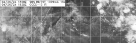
NHC展望提升至Medium1. Updated: A well-defined, non-tropical low pressure system is
located about 120 miles south of Cape Hatteras, North Carolina.
Satellite and radar data indicate that thunderstorm activity has
continued to increase and become more concentrated near the center
of the low early this morning, and environmental conditions are
expected to be at least marginally conducive for tropical cyclone
formation. If this recent development trend continues, then a
short-lived tropical depression or tropical storm could form later
today while the system moves northeastward away from the United
States. The low will move over colder waters south of Nova Scotia
on Wednesday, ending any opportunity for further development.
* Formation chance through 48 hours...medium...50 percent.
* Formation chance through 5 days...medium...50 percent. 
|
|