開啟輔助訪問
 找回密碼
 立即加入

29L.Eta 登陸佛州 轉化溫氣

簽到天數: 601 天

[LV.9]以壇為家II

2020-10-30 09:59 | 顯示全部樓層
  四級颶風  
編號:29 L
名稱:Eta
123454071_350814272684756_5856196811769484374_n.jpg
  基本資料  
擾動編號日期:2020 10 30 09
命名日期  :2020 11 01 11
撤編日期  :2020 11 14 02
登陸地點  :尼加拉瓜-北大西洋自治區

                       古巴-聖斯皮里圖斯省                        
                       美國-佛羅里達州

  巔峰時期資料  
近中心最強風速 :130  kt ( Cat.4 )
海平面最低氣壓 :923 百帕

  擾動編號資料  

90L.INVEST.15kts-1009mb-12N-78W 20201030.0130.goes-16.ir.96L.INVEST.15kts.1009mb.12N.78W.100pc.jpg
1. A large area of disturbed weather in the vicinity of the Lesser
Antilles is associated with a tropical wave.  Upper-level winds are
expected to become more conducive for development of this
disturbance during the next few days, and a tropical depression is
likely to form by the time the system reaches the western Caribbean
Sea early next week.
* Formation chance through 48 hours...low...30 percent.
* Formation chance through 5 days...high...70 percent.

two_atl_2d1.png
以上資料來自:NHC、颱風論壇整理製作

評分

參與人數 1水氣能量 +15 +1 收起 理由
king111807 + 15 + 1 熱帶擾動首帖

查看全部評分

回復

使用道具 舉報

簽到天數: 483 天

[LV.9]以壇為家II

dom|2020-10-30 16:18 | 顯示全部樓層
展望提升至medium 40%/80%
1. Shower activity associated with a large area of disturbed weather
over the Lesser Antilles and the eastern Caribbean Sea has become a
little more concentrated this evening.  Conditions are expected to
be conducive for development of this disturbance during the next
few days, and a tropical depression is likely to form by the time
the system reaches the western Caribbean Sea early next week.
* Formation chance through 48 hours...medium...40 percent.
* Formation chance through 5 days...high...80 percent.
two_atl_2d1.png 96L_intensity_latest.png
回復

使用道具 舉報

簽到天數: 483 天

[LV.9]以壇為家II

dom|2020-10-30 19:43 | 顯示全部樓層
展望提升至high
1. Shower activity continues to become better organized in association with a tropical wave located over the eastern Caribbean Sea. Conditions are conducive for further development of this system, and a tropical depression is likely to form this weekend or early next week as the system moves into the central and western Caribbean Sea.
* Formation chance through 48 hours...high...70 percent.
* Formation chance through 5 days...high...80 percent.
two_atl_2d0.png
回復

使用道具 舉報

簽到天數: 1650 天

[LV.Master]伴壇終老

老農民版夜神月|2020-10-31 20:35 | 顯示全部樓層
FWC-N1200Z發布TCFA,未來路徑變數頗大
可能持續西行登陸中美洲陸地,也可能北上墨西哥灣
甚至可能登陸中美洲後跨洋進入東太,總之尚待時間觀察

al962020.gif sm20201031.1200.goes-16.vis.2km.96L.INVEST.25kts.1007mb.14.5N.70.1W.pc.jpg

natl.png

回復

使用道具 舉報

簽到天數: 1650 天

[LV.Master]伴壇終老

老農民版夜神月|2020-11-1 05:00 | 顯示全部樓層
本帖最後由 老農民版夜神月 於 2020-11-1 05:03 編輯

NHC21Z升格29L,首報上望75節
000
WTNT44 KNHC 312050
TCDAT4

Tropical Depression Twenty-Nine Discussion Number   1
NWS National Hurricane Center Miami FL       AL292020
500 PM EDT Sat Oct 31 2020

Showers and thunderstorms have continued to become better organized
in association with a tropical wave which has been moving westward
across the central Caribbean Sea.  It was unclear this morning if
the system had developed a closed low-level circulation, since
scatterometers have avoided the system over the past 24 hours, but
recent visible and microwave satellite images suggest that the
system almost certainly now has a well-defined center.  For that
reason, the system is being designated as a tropical depression with
30-kt winds, based on Dvorak classifications of T2.0 from both TAFB
and SAB.

A low- to mid-level ridge axis that extends from the subtropical
Atlantic southwestward to Cuba and the Bahamas is currently steering
the depression toward the west (270 degrees) at an estimated speed
of 13 kt.  Model guidance is in fairly good agreement on the
depression's future track for the first 48 hours or so.  The cyclone
is expected to continue westward for the first 36 hours and then
slow down and turn west-southwestward by 48 hours as it approaches
the coasts of Nicaragua and Honduras, in response to a building
ridge over the Gulf of Mexico.  After that time, however, there is
significant divergence in the models.  For example, the ECWMF and
its ensemble members continue on a faster westward motion across
Central America, while the GFS and its ensemble members stall the
system over the western Caribbean Sea through day 5.  Given this
discrepancy, the NHC official track forecast shows a slow motion on
days 3 through 5, and brings the cyclone's center slowly across
northern Nicaragua, more or less in line with the multi-model
consensus aids.  This forecast is of generally low confidence,
however, and significant changes could be required in later advisory
packages depending on model trends.

The waters over the Caribbean Sea remain very warm--around 29
degrees Celsius--and the environment is characterized by low
vertical shear of 10 kt or less.  Along with plenty of ambient
moisture, these parameters suggest the system is primed for steady,
if not significant, strengthening during the next few days.  The NHC
official forecast generally lies between the SHIPS guidance and the
HCCA corrected-consensus aid, which lie near the upper bound of the
intensity guidance, and it brings the system to hurricane strength
in 48 hours.  The intensity forecast hinges greatly on whether or
not the cyclone's center moves inland over Central America, but
regardless, the system is expected to be a hurricane when it
approaches the Honduras and Nicaragua coasts in a few days.

Key Messages:

1. The depression is expected to strengthen to a hurricane early
next week as it approaches the coast of Central America late Monday
and Monday night, and there is a risk of storm surge,
hurricane-force winds, and heavy rainfall for portions of Nicaragua
and Honduras.  Hurricane Watches could be needed for portions of
those areas later tonight.

2. Through Thursday afternoon, heavy rainfall from the system will
likely lead to flash flooding and river flooding across portions of
Jamaica, the Cayman Islands, and Central America, which could result
in landslides in areas of higher terrain.  Flooding is also possible
near the southern coast of Hispaniola.


FORECAST POSITIONS AND MAX WINDS

INIT  31/2100Z 15.0N  73.2W   30 KT  35 MPH
12H  01/0600Z 15.1N  75.6W   35 KT  40 MPH
24H  01/1800Z 15.4N  78.3W   45 KT  50 MPH
36H  02/0600Z 15.5N  80.4W   55 KT  65 MPH
48H  02/1800Z 15.1N  82.1W   65 KT  75 MPH
60H  03/0600Z 14.3N  83.1W   75 KT  85 MPH
72H  03/1800Z 13.8N  83.7W   70 KT  80 MPH...INLAND
96H  04/1800Z 13.5N  85.5W   40 KT  45 MPH...INLAND
120H  05/1800Z 14.0N  86.9W   25 KT  30 MPH...INLAND

$$
Forecaster Berg
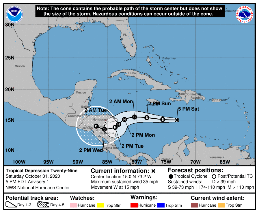
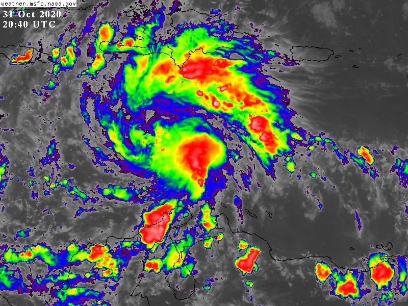
205124_5day_cone_with_line_and_wind.png GOES20402020305fm3Vbl.jpg
回復

使用道具 舉報

簽到天數: 1650 天

[LV.Master]伴壇終老

老農民版夜神月|2020-11-1 10:56 | 顯示全部樓層
03Z命名Eta
000
WTNT44 KNHC 010247
TCDAT4

Tropical Storm Eta Discussion Number   2
NWS National Hurricane Center Miami FL       AL292020
1100 PM EDT Sat Oct 31 2020

Satellite imagery indicates that shower activity associated with the
cyclone continues to become better organized, with a convective band
wrapping about halfway around the center.  Satellite intensity
estimates from TAFB and SAB have increased to 35 kt, and the CIMSS
satellite consensus is near 40 kt.  Based on these data, the
depression is upgraded to Tropical Storm Eta, the twenty-eighth
named storm of the 2020 season.  This ties the record for storms set
in the 2005 season and is the first time the name Eta has been used
in the Atlantic basin.

The initial motion is 275/13.  A low- to mid-level ridge axis that
extends from the subtropical Atlantic southwestward to Cuba and the
Bahamas is currently the main steering influence, and the model
guidance is in good agreement that this feature should cause the
storm to move westward for the next 24-36 h.  Between 36-72 h, a
building low- to mid-level ridge over the Gulf of Mexico should
cause Eta to turn west-southwestward as it approaches the coasts of
Nicaragua and Honduras.  Beyond that time, there remains
significant spread in the models, with the GFS showing a slow
motion toward the northwest near the coast of Honduras while the
ECMWF/UKMET show a continued west-southwestward motion into the
Pacific.  Given the spread, the NHC official track forecast shows
a slow motion on days 3 through 5, and brings the cyclone's center
slowly across portions of Nicaragua and Honduras.  The new forecast
track is close to the multi-model consensus, and the 72-120 h part
remains low confidence.

Eta is over warm water and is in environment of light vertical wind
shear. These conditions are expected to continue until the system
nears the coast of Central America on 60-72 h.  Thus, steady to
possibly rapid strengthening is expected, with the storm forecast to
reach hurricane strength between 36-48 h.  The intensity guidance
has trended stronger since the last advisory, and this part of the
new intensity forecast is now a little below the intensity
consensus.  After 72 h, the intensity forecast is tied to whether or
not the cyclone's center moves inland over Central America, and the
current forecast is based on the forecast track that takes the
center well inland.

Key Messages:

1. The depression is expected to strengthen to a hurricane early
next week as it approaches the coast of Central America late Monday
and Monday night, and there is a risk of storm surge,
hurricane-force winds, and heavy rainfall for portions of Nicaragua
and Honduras where Hurricane Watches have been issued.  Hurricane
warnings could be needed for portions of those areas on Sunday.

2. Through Thursday evening, heavy rainfall from Eta may lead to
flash flooding and river flooding across portions of Jamaica, the
Cayman Islands, and Central America, which could lead to landslides
in areas of higher terrain.  Flooding is also possible near the
southern coast of Hispaniola, depending upon the track of the storm.


FORECAST POSITIONS AND MAX WINDS

INIT  01/0300Z 15.0N  74.2W   35 KT  40 MPH
12H  01/1200Z 15.1N  76.4W   40 KT  45 MPH
24H  02/0000Z 15.3N  78.8W   50 KT  60 MPH
36H  02/1200Z 15.2N  80.8W   60 KT  70 MPH
48H  03/0000Z 14.7N  82.1W   70 KT  80 MPH
60H  03/1200Z 14.2N  82.8W   80 KT  90 MPH
72H  04/0000Z 13.7N  83.7W   70 KT  80 MPH...INLAND
96H  05/0000Z 14.0N  85.5W   35 KT  40 MPH...INLAND
120H  06/0000Z 14.5N  87.0W   25 KT  30 MPH...INLAND

$$
Forecaster Beven


025007_5day_cone_with_line_and_wind.png 29L_tracks_latest.png
natl (1).png

回復

使用道具 舉報

簽到天數: 1650 天

[LV.Master]伴壇終老

老農民版夜神月|2020-11-2 14:55 | 顯示全部樓層
NHC06Z升格C1
AL, 29, 2020110206, , BEST, 0, 149N, 804W, 65, 987, HU
sm20201102.0620.goes-16.ir.29L.ETA.65kts.987mb.14.9N.80.4W.100pc.jpg 20201102.0535.gpm.89pct89h89v.29L.ETA.60kts.989mb.14.9N.79.5W.050pc.jpg
20201102.0535.gpm.89hbt.29L.ETA.60kts.989mb.14.9N.79.5W.050pc.jpg 29L_tracks_latest (1).png
回復

使用道具 舉報

簽到天數: 483 天

[LV.9]以壇為家II

dom|2020-11-2 21:03 | 顯示全部樓層
升格C2,且看好登陸前衝更高強度,型態也不錯
AL, 29, 2020110212, , BEST, 0, 148N, 811W, 85, 974, HU, 34, NEQ, 100, 60, 40, 90, 1008, 210, 10, 0, 0, L, 0, , 0, 0, ETA, D,
goes16_ir_29L_202011021015.gif 82afd72a6059252de7f88544239b033b5ab5b95d.jpg
回復

使用道具 舉報

1234下一頁
快速回覆
您需要登錄後才可以回帖 登錄 | 立即加入

本版積分規則

本平台僅供學術討論之用,預報應以氣象局為準

威普網站虛擬主機贊助公司

臺灣第一個天氣類型社群平台 即時天氣資訊、精準颱風動態

線上客服
FB傳送訊息
廣告行銷
精準行銷 物超所值
官方粉專
發佈 快速回復 返回頂部 返回列表