開啟輔助訪問
 找回密碼
 立即加入

09L.Helene 達C4即將登陸 美國今年最強颶風

簽到天數: 4100 天

[LV.Master]伴壇終老

2024-9-23 03:58 | 顯示全部樓層
基本資料  
編號    :97 L
擾動編號日期:2024 09 23 02
撤編日期  :2024 09 00 00

AL, 97, 2024092218,   , BEST,   0, 153N,  832W,  20, 1007, DB,  34, NEQ

two_atl_0d0.png

two_atl_2d0.png


Tropical Weather Outlook Text        EspañolTropical Weather Discussion
ZCZC MIATWOAT ALL
TTAA00 KNHC DDHHMM

Tropical Weather Outlook
NWS National Hurricane Center Miami FL
200 PM EDT Sun Sep 22 2024

For the North Atlantic...Caribbean Sea and the Gulf of Mexico:


2. Northwestern Caribbean Sea and Gulf of Mexico:
Disorganized showers and thunderstorms located over the northwestern
Caribbean Sea and portions of Central America are associated with a
broad area of low pressure. Environmental conditions appear
favorable for development of this system, and a tropical depression
or tropical storm is likely to form during the next few days while
moving northward across the northwestern Caribbean Sea and Gulf of
Mexico. Regardless of development, this disturbance is expected to
produce heavy rains over portions of Central America during the next
several days. Interests in the northwestern Caribbean, Yucatan
Peninsula of Mexico, and western Cuba should closely monitor the
progress of this feature. Later this week, the system is forecast to
move generally northward across the Gulf of Mexico, and interests
along the northern and northeastern Gulf Coast should also monitor
the progress of this system.
* Formation chance through 48 hours...medium...40 percent.
* Formation chance through 7 days...high...80 percent.


goes16_ir_97L_202409221835_lat15.3-lon-83.2.jpg
回復

使用道具 舉報

簽到天數: 241 天

[LV.8]以壇為家I

krichard2011|2024-9-23 23:19 | 顯示全部樓層
NHC 認定潛在熱帶氣旋 並編號09L
並且將在當地時間下午進行颱風飛機實測

150611_5day_cone_no_line_and_wind.png

  1. 000
  2. WTNT44 KNHC 231500
  3. TCDAT4

  4. Potential Tropical Cyclone Nine Discussion Number   1
  5. NWS National Hurricane Center Miami FL       AL092024
  6. 1100 AM EDT Mon Sep 23 2024

  7. A broad area of low pressure over the northwestern Caribbean Sea
  8. continues to produce disorganized showers and thunderstorms. While
  9. some mid-level rotation is evident in visible satellite images,
  10. surface observations and visible satellite images suggest the
  11. low-level circulation remains broad and farther to the southwest.
  12. Nonetheless, the system has a high chance of tropical cyclone
  13. formation during the next day or two, and it is likely to bring
  14. tropical storm conditions to land areas within the next 36 to
  15. 48 hours. Therefore, the NHC is initiating Potential Tropical
  16. Cyclone advisories for this disturbance.

  17. The initial motion is quite uncertain given the current lack of
  18. organization, but the best estimate is northward at about 5 kt. A
  19. gradual turn toward the northwest is expected during the next day or
  20. so, with the center passing through the Yucatan Channel and into the
  21. southern Gulf of Mexico. Thereafter, the system is forecast to
  22. accelerate northward across the eastern Gulf of Mexico within the
  23. flow between a digging deep-layer trough over the central United
  24. States and a ridge over the western Atlantic. This motion should
  25. bring the center of the system toward the northeastern Gulf Coast on
  26. Thursday. The track guidance agrees reasonably well on this
  27. scenario, and the initial NHC forecast lies near the simple and
  28. corrected consensus aids. Since the disturbance currently lacks a
  29. well-defined center, users are reminded that the average forecast
  30. track uncertainty is larger in these situations, and future track
  31. adjustments may be required. Given the large size of the
  32. tropical-storm-force wind field and fast forward speed that is
  33. forecast, storm surge, wind, and rainfall impacts will likely extend
  34. well away from the center, particularly to the east of the system.

  35. While the system is currently broad and not well organized, the
  36. models suggest a more well-defined center should develop during the
  37. next day or so. Once the system becomes better organized and
  38. develops an inner core, the environmental and oceanic conditions
  39. appear favorable for significant strengthening. In fact, the DTOPS
  40. statistical guidance shows a 95 percent chance of a 65-kt increase
  41. in intensity during the next 72 h, and the hurricane regional models
  42. highlight the potential for strengthening to major hurricane
  43. intensity. Thus, the NHC forecast shows significant strengthening
  44. while the system moves across the eastern Gulf of Mexico, with a
  45. 95-kt intensity in 72 h. While this forecast is aggressive, it lies
  46. near or slightly below the consensus aids, and future adjustments
  47. may be necessary.  An Air Force Reserve reconnaissance aircraft is
  48. scheduled to investigate the system this afternoon.

  49. Based on the NHC forecast, Tropical Storm Warnings and Hurricane
  50. Watches have been issued for portions of western Cuba the Yucatan
  51. Peninsula of Mexico. Interests along the northeastern Gulf Coast,
  52. including the Florida Panhandle and portions of the Florida west
  53. coast should monitor the progress of this system.


  54. KEY MESSAGES:

  55. 1. The disturbance is forecast to strengthen and be near hurricane
  56. strength when it reaches the far northwestern Caribbean Sea Tuesday
  57. night. Tropical storm conditions are expected over portions of
  58. western Cuba and the northeastern coast of the Yucatan Peninsula
  59. with hurricane conditions possible.

  60. 2. The system is expected to intensify while it moves northward
  61. over the eastern Gulf of Mexico, and it could be a major hurricane
  62. when it reaches the northeastern Gulf Coast on Thursday. There is an
  63. increasing risk of life-threatening storm surge and damaging
  64. hurricane-force winds along portions of the northern and
  65. northeastern Gulf Coast, including the Florida Panhandle and
  66. portions of the Florida west coast. Although it is too soon to
  67. specify the exact location and magnitude of impacts, residents in
  68. these areas should monitor the latest forecast updates and ensure
  69. that they have their hurricane plan in place.

  70. 3. Potential Tropical Cyclone Nine will bring heavy rain to portions
  71. of the western Caribbean which may lead to flooding and possible
  72. mudslides in western Cuba.


  73. FORECAST POSITIONS AND MAX WINDS

  74. INIT  23/1500Z 17.6N  82.0W   25 KT  30 MPH...POTENTIAL TROP CYCLONE
  75. 12H  24/0000Z 18.6N  82.4W   30 KT  35 MPH...TROPICAL CYCLONE
  76. 24H  24/1200Z 19.5N  83.7W   40 KT  45 MPH
  77. 36H  25/0000Z 20.6N  85.1W   50 KT  60 MPH
  78. 48H  25/1200Z 22.1N  86.0W   65 KT  75 MPH
  79. 60H  26/0000Z 24.2N  86.0W   85 KT 100 MPH
  80. 72H  26/1200Z 27.1N  85.1W   95 KT 110 MPH
  81. 96H  27/1200Z 34.0N  83.0W   35 KT  40 MPH...INLAND
  82. 120H  28/1200Z 38.5N  87.0W   20 KT  25 MPH...POST-TROPICAL

  83. $$
  84. Forecaster Reinhart
複製代碼
回復

使用道具 舉報

簽到天數: 241 天

[LV.8]以壇為家I

krichard2011|2024-9-25 14:22 | 顯示全部樓層
NHC 昨日升格命名 Helene
後續上看C3
033010_5day_cone_no_line_and_wind.png
b15c6b97-9f55-496d-aac0-4c79fc15f00a.jpg


  1. 000
  2. WTNT44 KNHC 250256
  3. TCDAT4

  4. Tropical Storm Helene Discussion Number   7
  5. NWS National Hurricane Center Miami FL       AL092024
  6. 1000 PM CDT Tue Sep 24 2024

  7. Helene continues to become better organized with increased
  8. convective banding features and an overall more symmetrical-looking
  9. cloud pattern.  The convection is very deep with cloud tops to -80
  10. deg C or colder.  Doppler velocity data from a NOAA Hurricane
  11. Hunter aircraft indicate no significant vertical tilt of the
  12. vortex in the low- to mid-troposphere.  This suggests that the
  13. vertical wind shear is low.  Earlier flight-level wind data from the
  14. aircraft indicate the the maximum winds are near 50 kt, although
  15. this may be conservative.

  16. Although the storm has been wobbling over the past few hours,
  17. center fixes from the NOAA Hurricane Hunter aircraft indicate a
  18. generally west-northwestward motion at around 300/9 kt.  Helene
  19. should turn northwestward soon as a high pressure area over Florida
  20. shifts eastward, with the tropical cyclone center passing near the
  21. northeastern Yucatan Peninsula tomorrow morning.  Meanwhile, a
  22. mid-tropospheric trough is digging over the Lower Mississippi
  23. Valley.  This evolution of the steering flow should cause Helene to
  24. turn northward with an increase in forward speed during the next day
  25. or so.  An accelerating northward to north-northeastward motion over
  26. the eastern Gulf of Mexico should take the system to the
  27. northeastern Gulf of Mexico coast in about 48 hours.  After
  28. landfall, Helene should curve cyclonically around a mid-level low
  29. over the south-central United States.  The official forecast is very
  30. similar to the previous one and is on top of the latest corrected
  31. consensus track guidance.

  32. Over the next couple of days, Helene will be moving through an
  33. environment of low vertical wind shear, ample environmental
  34. moisture, and over waters of high oceanic heat content. Thus,
  35. significant strengthening is anticipated before landfall on the
  36. northeast Gulf coast.  The NHC intensity forecast explicitly shows
  37. steady to rapid intensification (RI) of 25 kt for the next 24 hours
  38. and 30 kt for the 24- to 48-hour forecast interval.  This is in
  39. general agreement with the SHIPS RI indices.

  40. Helene is predicted to grow to a very large size in the NHC
  41. forecast.  Therefore storm surge, wind, and rainfall impacts will
  42. likely extend well away from the center and outside the forecast
  43. cone, particularly on the east side.  In addition, the fast forward
  44. speed while it crosses the coast will likely result in farther
  45. inland penetration of strong winds over parts of the southeastern
  46. United States after landfall.


  47. KEY MESSAGES:

  48. 1. Helene is forecast to intensify and be near hurricane strength
  49. when it passes near the northeastern coast of the Yucatan
  50. Peninsula on Wednesday, where a Hurricane Warning is in effect.

  51. 2. Helene is expected to rapidly intensify and grow in size over the
  52. eastern Gulf of Mexico.  There is a danger of life-threatening storm
  53. surge along the entire west coast of the Florida Peninsula and
  54. Florida Big Bend.  The highest inundation levels are
  55. expected along the coast of the Florida Big Bend.  Residents in
  56. those areas should follow advice given by local officials and
  57. evacuate if told to do so.

  58. 3. Damaging hurricane-force winds are expected along portions of
  59. coast of the Florida Big Bend, where a Hurricane Warning is now in
  60. effect.  Preparations to protect life and property should be
  61. complete by early Thursday since tropical storm conditions are
  62. expected to begin within this area on Thursday.

  63. 4. Tropical Storm Helene will bring heavy rain to portions of the
  64. western Caribbean with potentially significant flooding across
  65. western Cuba and the northeastern Yucatan Peninsula.  Considerable
  66. flash and urban flooding is expected across portions of Florida, the
  67. Southeast, southern Appalachians, and the Tennessee Valley Wednesday
  68. through Friday.  This includes the risk of landslides across the
  69. southern Appalachians.  Widespread minor to moderate river flooding
  70. is likely, and isolated major river flooding is possible.


  71. FORECAST POSITIONS AND MAX WINDS

  72. INIT  25/0300Z 19.9N  85.5W   50 KT  60 MPH
  73. 12H  25/1200Z 21.1N  86.3W   65 KT  75 MPH
  74. 24H  26/0000Z 22.7N  86.4W   75 KT  85 MPH
  75. 36H  26/1200Z 25.4N  85.5W   90 KT 105 MPH
  76. 48H  27/0000Z 29.5N  84.2W  105 KT 120 MPH
  77. 60H  27/1200Z 34.0N  84.5W   30 KT  35 MPH
  78. 72H  28/0000Z 36.5N  86.5W   20 KT  25 MPH...POST-TROP/INLAND
  79. 96H  29/0000Z 37.0N  89.0W   20 KT  25 MPH...POST-TROP/INLAND
  80. 120H  30/0000Z...DISSIPATED

  81. $$
  82. Forecaster Pasch
複製代碼


回復

使用道具 舉報

該用戶從未簽到

kingchard2011|2024-9-25 23:43 | 顯示全部樓層
NHC 升格C1
上看110KT
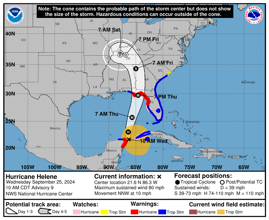
152934_5day_cone_no_line_and_wind.png

000
WTNT44 KNHC 251457
TCDAT4

Hurricane Helene Discussion Number   9
NWS National Hurricane Center Miami FL       AL092024
1000 AM CDT Wed Sep 25 2024

Air Force Reserve and NOAA Hurricane Hunter aircraft have been
investigating Helene, with each plane recently measuring peak
flight-level winds of 81 kt and 78 kt, respectively.  Helene has
therefore become a hurricane with an estimated intensity of 70 kt.  
Dropsonde data also indicate that the pressure has fallen to about
979 mb.  Radar data from Mexico and Cuba, as well as reconnaissance
reports, indicate that Helene has formed a partial, elliptical
eyewall that is open on the east side.

Helene has turned north-northwestward (330/9 kt) and is expected to
turn northward and north-northeastward later today and tonight,
bringing the center to the coast of the Florida Big Bend Thursday
evening. After landfall, Helene is expected to interact with a
deep-layer trough over the Lower Mississippi Valley and swing back
to the northwest and stall near the Tennessee Valley late Friday
into the weekend.  The track guidance remains tightly clustered,
and the NHC forecast is generally just an update of the previous
prediction. It is still too soon at this point to be overly focused
on an exact landfall location and time, since NHC track forecasts
can be off by an average of 60 nm at the 36-hour forecast time.

Helene is expected to move through/over an environment of
relatively low shear, strong upper-level divergence, and sea
surface temperatures of 29-31 degrees Celsius, all of which should
foster additional strengthening.  Rapid Intensification (RI)
indices indicate a high chance of RI during the next 24 hours, and
as a result the NHC intensity forecast shows Helene becoming a
major hurricane by Thursday morning.  There is still some
uncertainty on exactly how strong Helene will get, and upward
adjustments to the forecast intensity could be required in
subsequent advisories if Helene rapidly intensifies more than
forecast.  Regardless, Helene is forecast to be a large major
hurricane when it reaches the Big Bend coast of Florida.   As a
result, storm surge, wind, and rainfall impacts will likely extend
well away from the center and outside the forecast cone,
particularly on the east side.  In addition, the fast forward speed
while Helene crosses the coast will likely result in farther inland
penetration of strong winds over parts of the southeastern United
States after landfall, including strong gusts over higher terrain
of the southern Appalachians.


KEY MESSAGES:

1. Hurricane and tropical storm conditions are expected over
northeastern portions of the Yucatan Peninsula of Mexico today where
Tropical Storm and Hurricane Warnings are in effect.  Tropical storm
conditions are occurring over portions of western Cuba within the
Tropical Storm Warning area, and hurricane conditions are possible
today within the Hurricane Watch area.

2. Due to the large size of Helene, there is a danger of
life-threatening storm surge along the entire west coast of the
Florida Peninsula and Florida Big Bend.  The highest inundation of
greater than 10 ft is expected along the Florida Big Bend coast.
Residents in those areas should follow advice given by local
officials and evacuate if told to do so.

3. Devastating hurricane-force winds are expected across portions
of northern Florida and southern Georgia where the core of Helene
moves inland.  Preparations to protect life and property should be
completed by early Thursday since tropical storm conditions are
expected to begin within these areas on Thursday.  Because of
Helene’s expected fast forward speed, damaging and life-threatening
wind gusts, are expected to penetrate well inland over portions of
the southeastern United States, including in the higher terrain of
the southern Appalachians.  

4. Helene will bring heavy rain to portions of the western
Caribbean with potentially significant flooding across western Cuba
and the northeastern Yucatan Peninsula into early Thursday.
Considerable and potentially life-threatening flash and urban
flooding is expected across portions of northwestern and northern
Florida, the Southeast, southern Appalachians, and the Upper
Tennessee Valley Wednesday through Friday. This includes the risk of
landslides across the southern Appalachians. Widespread minor to
moderate river flooding is likely, and isolated major river flooding
is possible.


FORECAST POSITIONS AND MAX WINDS

INIT  25/1500Z 21.6N  86.3W   70 KT  80 MPH
12H  26/0000Z 23.0N  86.4W   85 KT 100 MPH
24H  26/1200Z 25.7N  85.7W  105 KT 120 MPH
36H  27/0000Z 29.7N  84.6W  110 KT 125 MPH
48H  27/1200Z 34.3N  85.0W   50 KT  60 MPH...INLAND
60H  28/0000Z 36.6N  86.9W   30 KT  35 MPH...POST-TROP/INLAND
72H  28/1200Z 36.9N  87.8W   20 KT  25 MPH...POST-TROP/INLAND
96H  29/1200Z 36.6N  87.9W   15 KT  15 MPH...POST-TROP/INLAND
120H  30/1200Z...DISSIPATED

$$
Forecaster Berg
回復

使用道具 舉報

簽到天數: 241 天

[LV.8]以壇為家I

krichard2011|2024-9-27 08:40 | 顯示全部樓層
Helene 即將登陸

強度也進一步來到C4 115KT 氣壓 942hPa
由於已經相當靠近陸地
強度推測已達巔峰
但仍是將會是今年美國登陸最強颶風
49724f41-0897-4a6c-af05-8f880bf8dfe9.jpg
211601_5day_cone_no_line_and_wind.png
recon_AF306-1809A-HELENE_zoom.png
recon_AF306-1809A-HELENE.png
  1. 076
  2. WTNT44 KNHC 262043
  3. TCDAT4

  4. Hurricane Helene Discussion Number  14
  5. NWS National Hurricane Center Miami FL       AL092024
  6. 500 PM EDT Thu Sep 26 2024

  7. Helene has rapidly intensified today while nearing landfall in the
  8. Florida Big Bend.  Doppler radar and aircraft data indicate that the
  9. eyewall is now completely closed and the eye has become more
  10. circular and is clearing out.  The aircraft data also indicated
  11. that the inner core has contracted significantly today while the
  12. tropical-storm-force winds have expanded.  Based on all of the data,
  13. the initial intensity is set at 110 kt.  The latest minimum pressure
  14. based on the aircraft data is around 951 mb. Tropical-storm-force
  15. winds are occurring across portions of west-central and southwestern
  16. Florida, and conditions are expected to deteriorate rapidly in the
  17. hurricane warning area during the next several hours.  It should be
  18. emphasized that Helene is at the upper bound of hurricanes in
  19. terms of storm size and impacts are and will occur well away
  20. from the center.

  21. The large hurricane is now accelerating north-northeastward, with
  22. the latest initial motion estimated to be 025/20 kt.  This general
  23. motion is expected to continue, taking the core of the major
  24. hurricane to the Florida Big Bend later this evening.  After
  25. landfall, a turn to the north over Georgia is expected late tonight
  26. and early Friday, followed by a slowdown or a complete stall over
  27. the Tennessee Valley late Friday and Saturday when Helene merges
  28. with a mid- to upper-level low.

  29. The hurricane has intensified by 30 kt since sunrise and given the
  30. conducive environmental conditions and contracting inner core, it
  31. seems likely that Helene will be at or very near category 4 strength
  32. when it makes landfall in the Florida Big Bend this evening.
  33. The fast forward speed when Helene moves inland will result in a
  34. far inland penetration of strong winds over parts of the
  35. southeastern United States, including strong gusts over the higher
  36. terrain of the southern Appalachians.  Accordingly, a
  37. higher-than-normal gust factor is indicated in the official forecast
  38. while Helene is inland.

  39. KEY MESSAGES:

  40. 1. A catastrophic and deadly storm surge will occur along portions
  41. of the Florida Big Bend coast, where inundation could reach as high
  42. as 20 feet above ground level, along with destructive waves.  If
  43. you live in this area and were told to evacuate by local officials,
  44. your opportunity to do so is almost over.  There is also a danger
  45. of life-threatening storm surge along the remainder of the west
  46. coast of the Florida Peninsula.  

  47. 2. Potentially catastrophic hurricane-force winds are expected
  48. within the eyewall of Helene and will spread inland over portions
  49. of northern Florida and southern Georgia when Helene makes landfall
  50. in the Florida Big Bend region this evening.  Persons in these
  51. areas should be prepared to take shelter in the interior portion of
  52. a well-built structure and remain sheltered until after hazardous
  53. conditions pass. You may need to remain sheltered after the storm
  54. due to downed trees and power lines, as well as flooding, in the
  55. area.

  56. 3. Damaging wind gusts will penetrate well inland over portions of
  57. Georgia and the Carolinas  tonight, particularly over the higher
  58. terrain of the southern Appalachians. Residents in these areas
  59. should be prepared for the possibility of long-duration power
  60. outages.  If you use a generator after the storm, be sure it is
  61. placed outside at least 20 feet away from doors, windows, and
  62. garages to avoid deadly carbon monoxide poisoning.

  63. 4. Catastrophic and life-threatening flash and urban flooding,
  64. including numerous significant landslides, is expected across
  65. portions of the southern Appalachians through Friday. Considerable
  66. to locally catastrophic flash and urban flooding is likely for
  67. northwestern and northern Florida and the Southeast through Friday.
  68. Widespread significant river flooding and isolated major river
  69. flooding are likely.


  70. FORECAST POSITIONS AND MAX WINDS

  71. INIT  26/2100Z 27.9N  84.6W  110 KT 125 MPH
  72. 12H  27/0600Z 31.5N  83.7W   90 KT 105 MPH...INLAND
  73. 24H  27/1800Z 35.8N  85.0W   40 KT  45 MPH...POST-TROP/EXTRATROP
  74. 36H  28/0600Z 37.0N  86.5W   30 KT  35 MPH...POST-TROP/EXTRATROP
  75. 48H  28/1800Z 37.1N  87.0W   25 KT  30 MPH...POST-TROP/EXTRATROP
  76. 60H  29/0600Z 37.1N  87.3W   20 KT  25 MPH...POST-TROP/EXTRATROP
  77. 72H  29/1800Z...DISSIPATED

  78. $$
  79. Forecaster Cangialosi
複製代碼


回復

使用道具 舉報

快速回覆
您需要登錄後才可以回帖 登錄 | 立即加入

本版積分規則

本平台僅供學術討論之用,預報應以氣象局為準

威普網站虛擬主機贊助公司

臺灣第一個天氣類型社群平台 即時天氣資訊、精準颱風動態

線上客服
FB傳送訊息
廣告行銷
精準行銷 物超所值
官方粉專
發佈 快速回復 返回頂部 返回列表