開啟輔助訪問
 找回密碼
 立即加入
查看數: 9564 評論數: 13 收藏 0切换到帖子模式
    組圖打開中,請稍候......
發佈時間: 2021-9-13 19:05

正文摘要:

  熱帶風暴   編號:16 L 名稱:Peter 以上資料來自:NHC、颱風論壇整理製作

周子堯@FB 發表於 2021-9-19 17:06
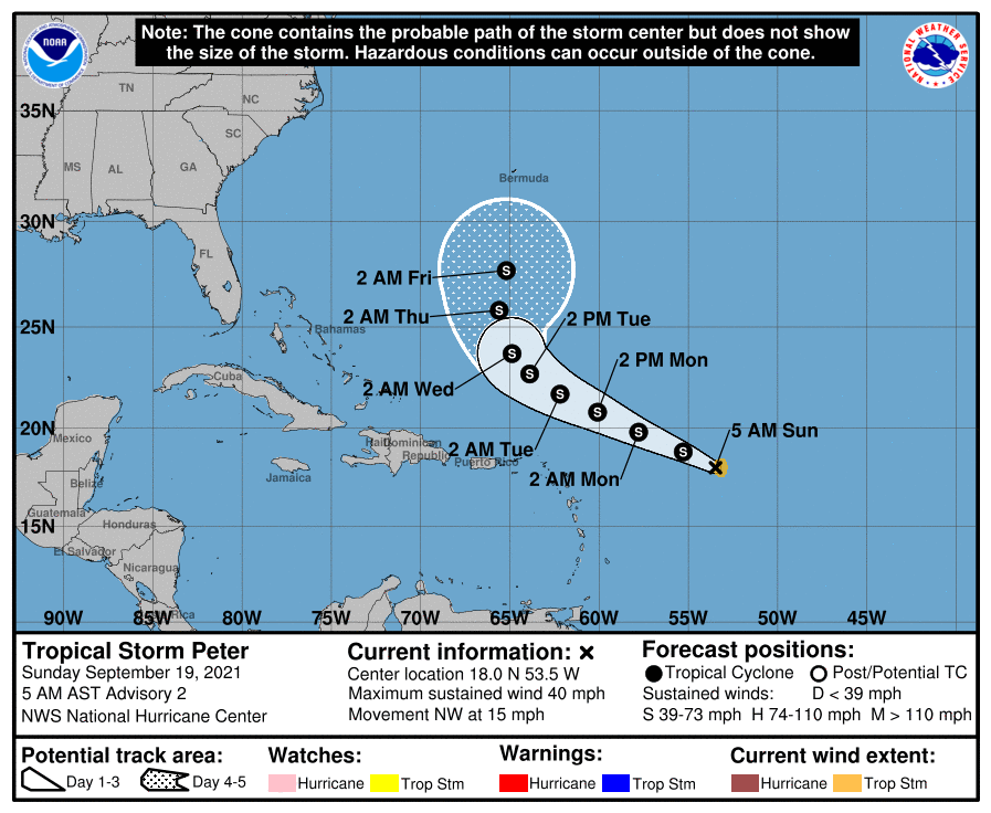
NHC 09Z命名Peter,巔峰僅預估到40kts
WTNT41 KNHC 190849
TCDAT1

Tropical Storm Peter Discussion Number   2
NWS National Hurricane Center Miami FL       AL162021
500 AM AST Sun Sep 19 2021

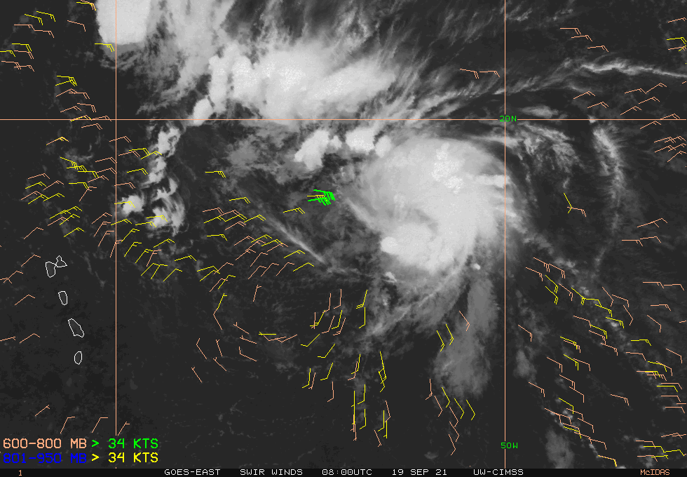
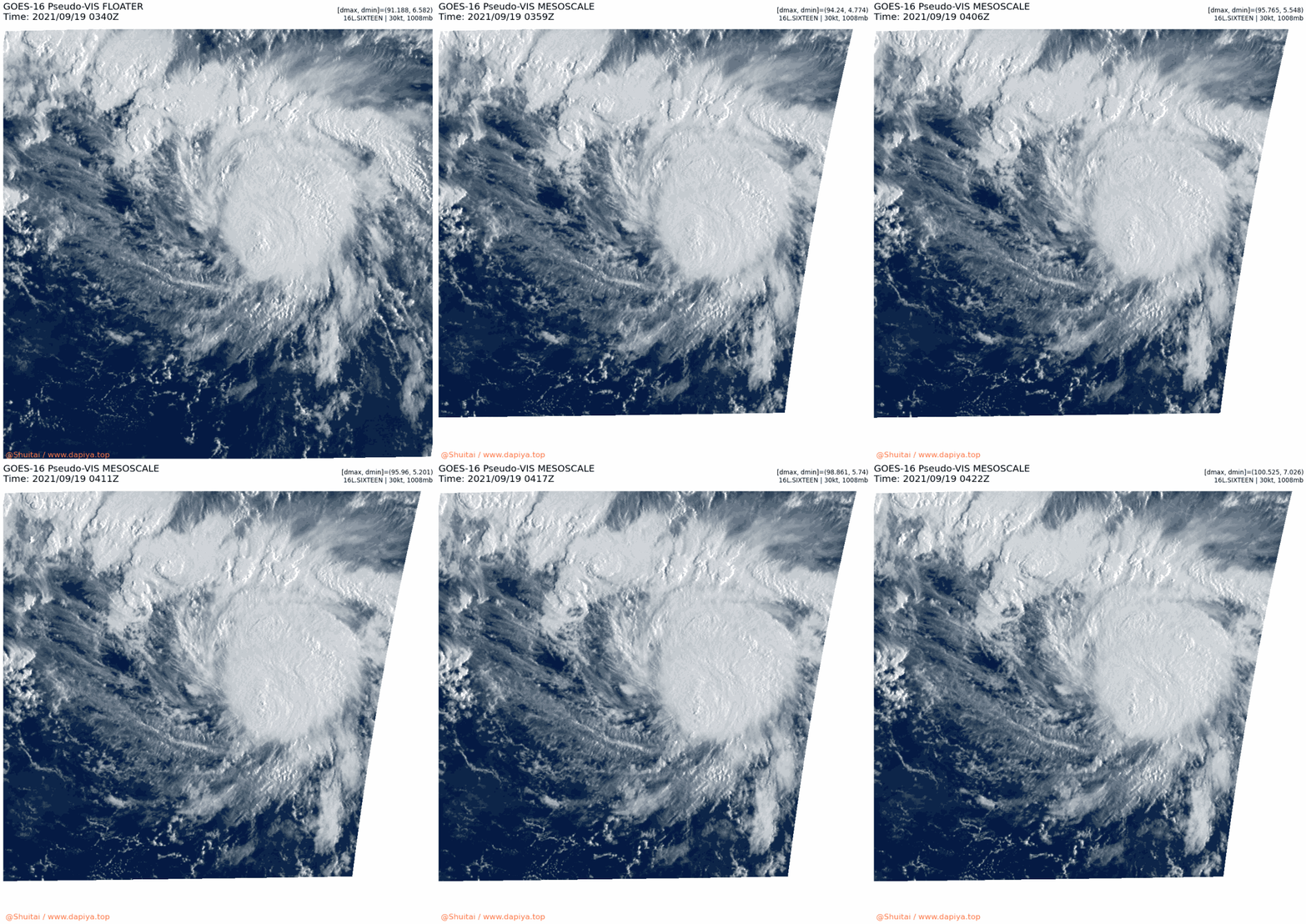
Deep convection has increased since the previous advisory, with the
convective cloud pattern having taken on a more curved-band
configuration compared to the earlier shear pattern. Satellite
intensity estimates from TAFB and SAB support increasing the
intensity to 35 kt. In addition, earlier ASCAT passes, which missed
the center of circulation, did reveal 30-kt winds west of the center
in convection-free areas. Thus, it is reasonable to assume that
stronger winds are occurring within the deep convection east of the
center, which further supports upgrading the system to Tropical
Storm Peter with a 35-kt intensity.

The initial estimate is an uncertain 305/13 kt. Peter has made a
slight jog to the north-northwest since the previous advisory, but
this is likely a short-term motion owing to the center redeveloping
farther to the north and east into the deep convection. However, a
west-northwestward motion is expected to resume later today.
Thereafter, the cyclone is forecast to maintain a west-northwestward
motion through Wednesday as Peter moves around the southwestern
periphery of a strong deep-layer subtropical ridge. On Thursday and
Friday, Peter is forecast to turn northward into a weakness in the
ridge induced by the large Post-Tropical Cyclone Odette.  The new
forecast track has been shifted slightly to the right or north of
the previous advisory track, mainly due to the more northward
initial position, and lies close to the consensus track models TVCA
and HCCA.

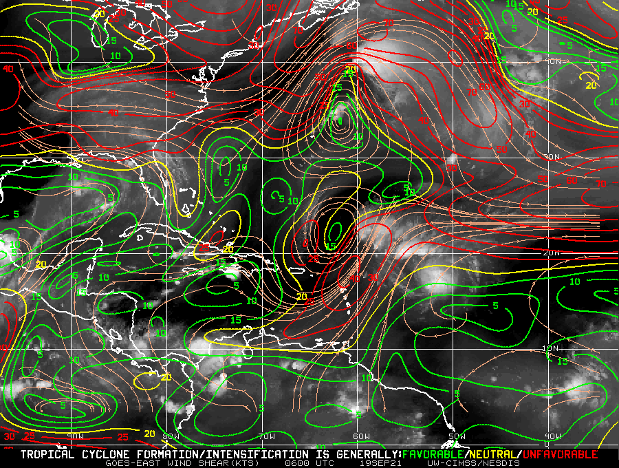
Some strengthening is forecast during the next 24 hours or so as
Peter moves over warmer sea-surface temperatures of about 29 deg C.
However, proximity to very dry mid-level air and moderate
deep-layer southwesterly vertical wind shear are expected to prevent
any significant or rapid strengthening. By early Tuesday and
beyond, slow weakening is expected to begin due to increasing wind
shear.  The new official NHC intensity forecast is very similar to
the previous advisory, and closely follows a blend of the IVCN and
HCCA intensity consensus models.

Based on the track, intensity, and wind radii forecast, no tropical
storm watches or warnings are required for the northern Leeward
Islands, Virgin Islands or Puerto Rico.  However, interests there
should monitor the progress of the system as locally heavy rain is
possible on Monday and Tuesday when it is expected to pass to the
north of the area.

Key Messages:

1. Rainfall around the southern periphery of Tropical Storm Peter
may lead to areas of urban and small stream flooding from late
Sunday into Tuesday across Puerto Rico, the Virgin Islands, and the
Northern Leeward Islands.

FORECAST POSITIONS AND MAX WINDS

INIT  19/0900Z 18.0N  53.5W   35 KT  40 MPH
12H  19/1800Z 18.8N  55.3W   40 KT  45 MPH
24H  20/0600Z 19.8N  57.8W   40 KT  45 MPH
36H  20/1800Z 20.8N  60.1W   40 KT  45 MPH
48H  21/0600Z 21.7N  62.2W   35 KT  40 MPH
60H  21/1800Z 22.7N  63.9W   35 KT  40 MPH
72H  22/0600Z 23.7N  64.9W   35 KT  40 MPH
96H  23/0600Z 25.8N  65.6W   35 KT  40 MPH
120H  24/0600Z 27.7N  65.2W   35 KT  40 MPH

$$
Forecaster Stewart
090141_5day_cone_no_line_and_wind.png
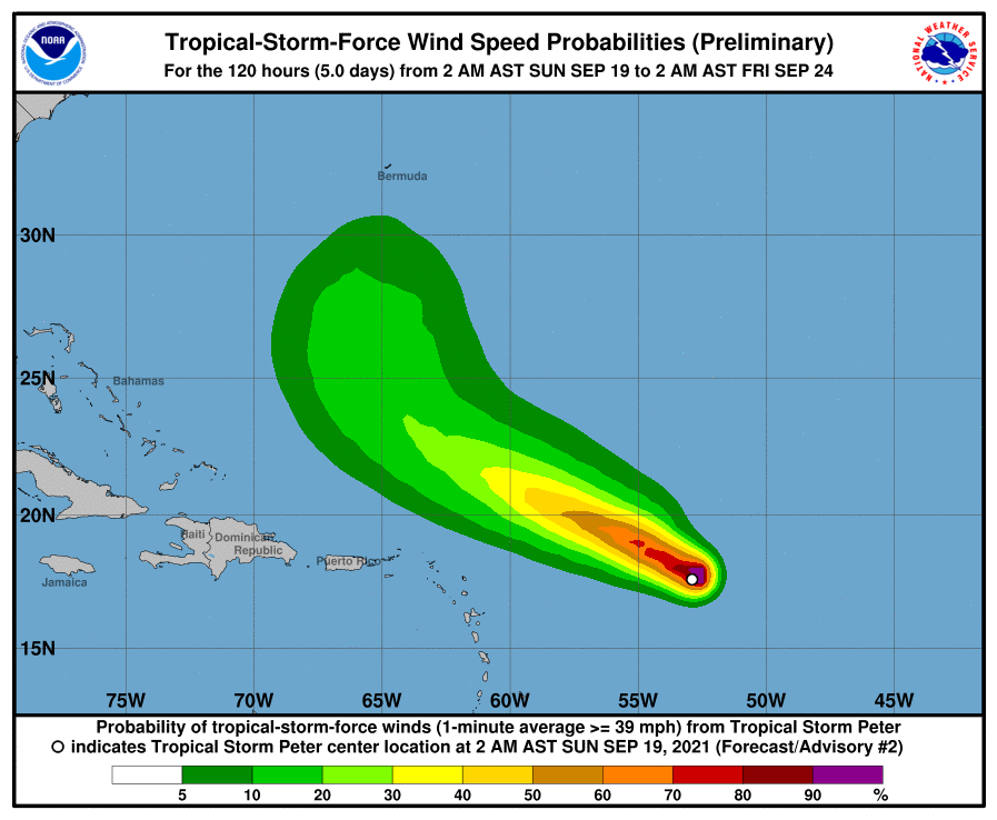
090141.png
wg8shr.gif
wg8vis.gif
周子堯@FB 發表於 2021-9-19 12:50
升格16L,發展較預期顯著,預估巔峰有機會到達TS
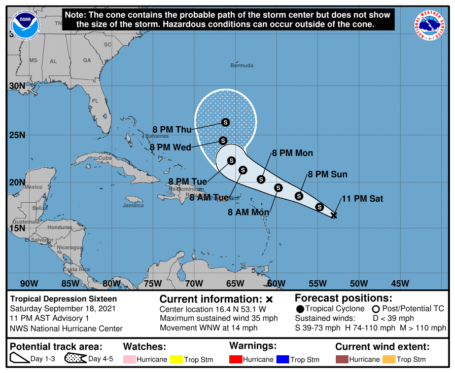
WTNT41 KNHC 190231
TCDAT1

Tropical Depression Sixteen Discussion Number   1
NWS National Hurricane Center Miami FL       AL162021
1100 PM AST Sat Sep 18 2021

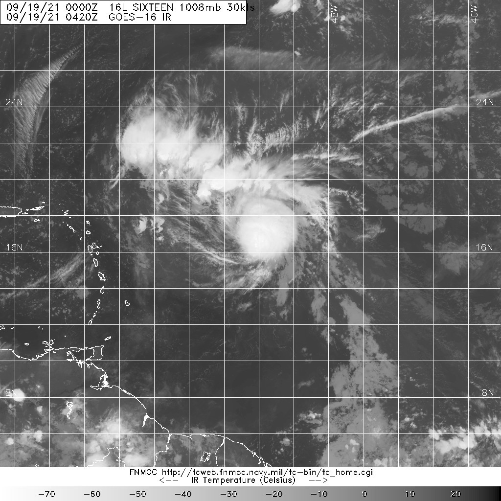
Satellite images and surface observations indicate that the area of
low pressure that NHC has been monitoring to the east of the
northern Leeward Islands now has a well-defined center and
sufficiently organized deep convection to be classified a tropical
depression.  The depression has a small area of deep convection near
its center and curved bands on its north and east sides.  The
initial intensity is estimated to be 30 kt, but this is a little
below the latest Dvorak classifications and could be conservative.

The depression is moving west-northwestward at 12 kt.  The cyclone
should continue west-northwestward at about the same pace during the
next few days as it moves in the flow on the southwest side of a
mid-level ridge.  After that time, the ridge is expected to break
down and the steering currents are forecast to become weak.  Not
surprisingly, the spread in the models increases around that time,
but most of the solutions show a slow turn toward the north toward
broad troughing associated with Post-Tropical Cyclone Odette.  The
GFS is on the southern side of the guidance envelope and the ECMWF
on the northern side. The NHC track forecast lies between those
models near the consensus aids.

Some strengthening seems possible during the next 12 to 24 hours and
the system is expected to become a tropical storm during that time
frame.  However, an increase in southerly and then southwesterly
vertical wind shear should cause the system to level off in strength
from 24 hours through the end of the forecast period.  The models
are in fairly good agreement on this overall scenario, and the NHC
intensity forecast is in line with the majority of the guidance.

Based on the track, intensity, and wind radii forecast, no tropical
storm watches or warnings are required for the northern Leeward
Islands, Virgin Islands or Puerto Rico.  However, interests there
should monitor the progress of the system as locally heavy rain is
possible on Monday and Tuesday when it is expected to pass to the
north of the area.


FORECAST POSITIONS AND MAX WINDS

INIT  19/0300Z 16.4N  53.1W   30 KT  35 MPH
12H  19/1200Z 17.3N  54.8W   35 KT  40 MPH
24H  20/0000Z 18.5N  57.3W   40 KT  45 MPH
36H  20/1200Z 19.4N  59.8W   40 KT  45 MPH
48H  21/0000Z 20.3N  61.9W   35 KT  40 MPH
60H  21/1200Z 21.3N  64.1W   35 KT  40 MPH
72H  22/0000Z 22.3N  65.5W   35 KT  40 MPH
96H  23/0000Z 24.4N  66.5W   35 KT  40 MPH
120H  24/0000Z 26.3N  66.2W   35 KT  40 MPH

$$
Forecaster Cangialosi
023220_5day_cone_no_line_and_wind.png
20210919.0420.goes-16.ir.16L.SIXTEEN.30kts.1008mb.16.1N.52.5W.100pc.jpg
16L_BAND01.gif

king111807 發表於 2021-9-18 16:02
NHC展望升至90%
1. Showers and thunderstorms continue to become better organized in
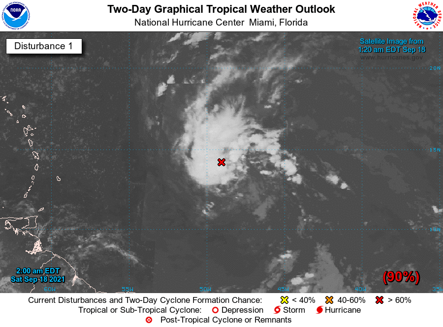
association with an area of low pressure located less than 1000
miles east-southeast of the northern Leeward Islands. Environmental
conditions are expected to be conducive for further development
during the next day or two, and a tropical depression is likely to
form later today or tomorrow while the system moves toward the
west-northwest at about 15 mph.  This system is expected to be near
the northern Leeward Islands on Monday and Tuesday, and interests
there should monitor the progress of this disturbance.  Upper-level
winds are likely to become less conducive for development when the
system reaches the southwestern Atlantic by the early to middle part
of next week.  
* Formation chance through 48 hours...high...90 percent.
* Formation chance through 5 days...high...90 percent.
two_atl_2d1.png
周子堯@FB 發表於 2021-9-18 08:29
本帖最後由 周子堯@FB 於 2021-9-18 21:16 編輯

NHC評級再提升至High
1. Showers and thunderstorms are gradually becoming better organized in
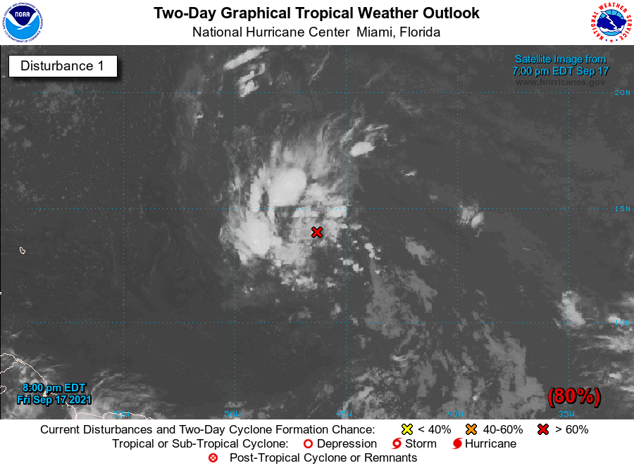
association with an area of low pressure located about 1100 miles
east-southeast of the northern Leeward Islands. Environmental
conditions are expected to be conducive for further development
during the next couple of days, and a tropical depression is likely
to form during the next day or two while the system moves toward the
west-northwest at about 15 mph.  This system is expected to be near
the northern Leeward Islands on Monday and Tuesday, and interests
there should monitor the progress of this disturbance.  Upper-level
winds are likely to become less conducive for development when the
system reaches the southwestern Atlantic by the early to middle part
of next week.  
* Formation chance through 48 hours...high...80 percent.
* Formation chance through 5 days...high...80 percent.

two_atl_2d1.png

點評

是High XD~  發表於 2021-9-18 16:03
king111807 發表於 2021-9-17 11:58
NHC展望降至Medium,60%
1. Showers and thunderstorms remain disorganized and somewhat limited
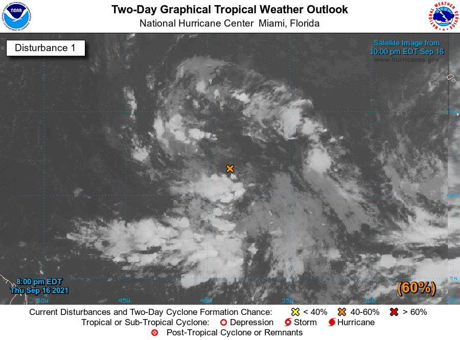
in association with a tropical wave and broad area of low pressure
located about 1000 miles west-southwest of the Cabo Verde Islands.  
However, environmental conditions are expected to be conducive for
development during the next few days, and a tropical depression
could still form over the weekend.  This system is expected to move
westward to west-northwestward across the tropical Atlantic during
the next several days.
* Formation chance through 48 hours...medium...60 percent.
* Formation chance through 5 days...high...70 percent.
two_atl_2d1.png
king111807 發表於 2021-9-16 20:23
NHC展望降至70%
1. Showers and thunderstorms have become slightly less organized in
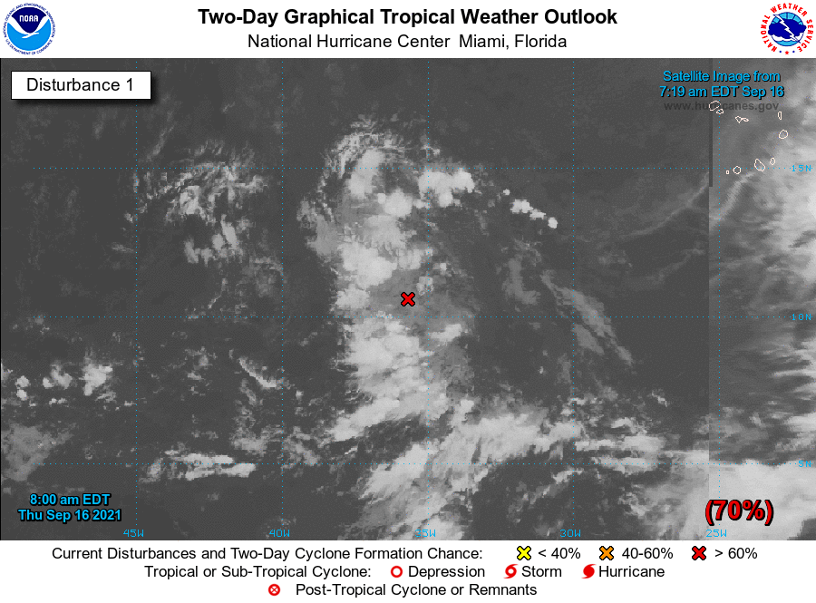
association with a tropical wave located a little more than 800
miles west-southwest of the Cabo Verde Islands.  However,  
environmental conditions are expected to be conducive for
development during the next few days, and a tropical depression is
still likely to form late this week or this weekend.  This system
is expected to move westward to west-northwestward across the
tropical Atlantic during the next several days.
* Formation chance through 48 hours...high...70 percent.
* Formation chance through 5 days...high...80 percent.
two_atl_2d1.png

本平台僅供學術討論之用,預報應以氣象局為準

威普網站虛擬主機贊助公司

臺灣第一個天氣類型社群平台 即時天氣資訊、精準颱風動態

線上客服
FB傳送訊息
廣告行銷
精準行銷 物超所值
官方粉專
發佈 快速回復 返回頂部 返回列表