開啟輔助訪問
 找回密碼
 立即加入

09L.Harvey 二次登陸 德州雨量破紀錄

查看數: 36527 評論數: 36 收藏 0切换到帖子模式
    組圖打開中,請稍候......
發佈時間: 2017-8-13 17:48

正文摘要:

  四級颶風   編號:09 L 名稱:Harvey   基本資料   擾動編號日期:2017 年 08 月 13 日 17 時 命名日期  :2017 年 08 月 17 日 05 時 二次升格日期:2017 年 08 月 2 ...

蜜露 發表於 2017-9-5 17:09


iCyclone 最新公佈了完整的哈維颶風的影片 .

這是聖體市北邊的Rockport  颶風獵人所經歷的恐怖颶風

形容卡翠娜後登美最強.


蜜露 發表於 2017-9-3 12:33
本帖最後由 蜜露 於 2017-9-3 12:40 編輯


其實哈維的強度和梅姬差不多 .

蘭斯博格(天鴿) 諾娃(哈維 伊瑪?)的卑鄙手段 .
比莎莎(梅姬)還要卑鄙 .

bandicam 2017-08-30 18-41-12-876.jpg


這次哈維登陸時, 速度實在減慢很多,還是陸地和海岸邊緣上去 . 對流有效增強.
高低層分離發展的感覺, 從德克薩斯跑到路易斯安那的海岸邊緣.

( 諾娃持續的朝對方扭打、凌虐, 至少綁了對方兩天兩夜 )
不像梅姬撞擊台灣後就直奔福建去了 . 沒有太多的滯留給於發展空間

(其實莎莎已經後悔過去的犯錯 2017年9月劇情)


蕭秋水@FB 發表於 2017-9-1 12:21
這種貼的海岸線纏了四五天....只能說連台灣也少有這種格格禪的颱風
(納莉是滯留兩天..偉恩來來去去..莫拉克是後續西南氣流)
...
水庫都爆炸..
(不知怎麼說 因為德州議員對天氣協定的反對)  居然有點暗爽
t02436 發表於 2017-8-30 23:37
補充,09Z登陸路易斯安那州,德州夢靨即將結束。
ZCZC MIATCPAT4 ALL
TTAA00 KNHC DDHHMM

BULLETIN
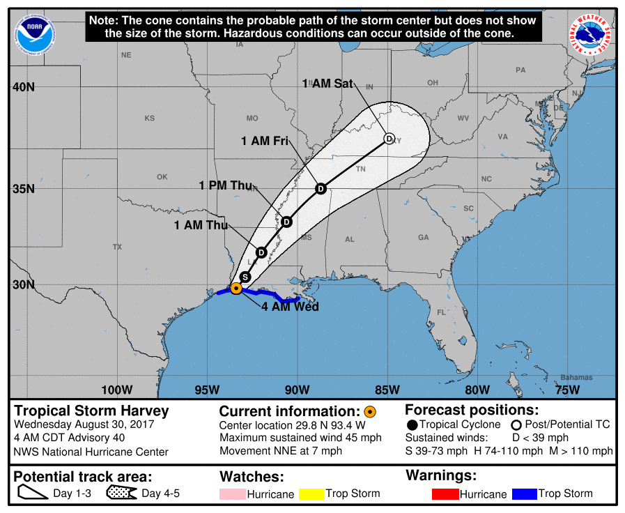
Tropical Storm Harvey Advisory Number  40
NWS National Hurricane Center Miami FL       AL092017
400 AM CDT Wed Aug 30 2017

...HARVEY MAKES LANDFALL JUST WEST OF CAMERON LOUISIANA...
...FLOODING RAINS DOUSING EXTREME SOUTHEASTERN TEXAS AND
SOUTHWESTERN LOUISIANA...


SUMMARY OF 400 AM CDT...0900 UTC...INFORMATION
----------------------------------------------
LOCATION...29.8N 93.4W
ABOUT 5 MI...10 KM W OF CAMERON LOUISIANA
ABOUT 30 MI...50 KM ESE OF PORT ARTHUR TEXAS
MAXIMUM SUSTAINED WINDS...45 MPH...75 KM/H
PRESENT MOVEMENT...NNE OR 30 DEGREES AT 7 MPH...11 KM/H
MINIMUM CENTRAL PRESSURE...990 MB...29.24 INCHES


WATCHES AND WARNINGS
--------------------
CHANGES WITH THIS ADVISORY:

The Tropical Storm Warning and Storm Surge Watch have been
discontinued from High Island, Texas, westward.

SUMMARY OF WATCHES AND WARNINGS IN EFFECT:

A Storm Surge Warning is in effect for...
* Holly Beach Louisiana to Morgan City Louisiana

A Storm Surge Watch is in effect for...
* East of High Island Texas to west of Holly Beach Louisiana

A Tropical Storm Warning is in effect for...
* East of High Island Texas to Grand Isle Louisiana

Catastrophic and life-threatening flooding continues in southeastern
Texas and portions of southwestern Louisiana.  Please see warnings
and other products issued by your local National Weather Service
office for additional information on this life-threatening
situation.

A Storm Surge Warning means there is a danger of life-threatening
inundation, from rising water moving inland from the coastline,
during the next 12 hours in the indicated locations.  For a
depiction of areas at risk, please see the National Weather
Service Storm Surge Watch/Warning Graphic, available at
hurricanes.gov.  This is a life-threatening situation.  Persons
located within these areas should take all necessary actions to
protect life and property from rising water and the potential for
other dangerous conditions.  Promptly follow evacuation and other
instructions from local officials.

For storm information specific to your area, including possible
inland watches and warnings, please monitor products issued by your
local National Weather Service forecast office.


DISCUSSION AND 48-HOUR OUTLOOK
------------------------------
At 400 AM CDT (0900 UTC), the center of Tropical Storm Harvey was
located just inland near latitude 29.8 North, longitude 93.4 West.
Harvey is moving toward the north-northeast near 7 mph (11 km/h).  A
north-northeastward and then northeastward motion at a faster
forward speed is expected through Thursday night.  On the forecast
track, the center of Harvey will move across the Lower Mississippi
Valley and Tennessee Valley through Thursday.

Maximum sustained winds are near 45 mph (75 km/h) with higher gusts.
Gradual weakening is forecast now that the center has crossed the
coast, and Harvey is expected to become a tropical depression by
tonight.

Tropical-storm-force winds extend outward up to 80 miles (130 km)
from the center.

Surface observations indicate that the estimated minimum central
pressure is 990 mb (29.24 inches).


HAZARDS AFFECTING LAND
----------------------
RAINFALL:  Harvey is expected to produce additional rainfall
accumulations of 3 to 6 inches from southwestern Louisiana and the
adjacent border of eastern Texas northeastward into western Kentucky
through Friday with isolated amounts up to 10 inches.  While the
threat of heavy rains has ended in the Houston/Galveston area,
catastrophic and life-threatening flooding will continue in and
around Houston eastward into southwest Louisiana for the rest of the
week.  The expected heavy rains spreading northeastward from
Louisiana into western Kentucky may also lead to flash flooding and
increased river and small stream flooding.  DO NOT ATTEMPT TO TRAVEL
IN THE AFFECTED AREA IF YOU ARE IN A SAFE PLACE.  DO NOT DRIVE INTO
FLOODED ROADWAYS.  Please see warnings and products issued by your
local National Weather Service office for additional information on
this life-threatening situation.

Elsewhere, the outer bands of Harvey are expected to produce
additional rainfall amounts of 3 to 6 inches over portions of the
central and eastern Gulf States and 2 to 4 inches farther north into
parts of the Tennessee Valley through Friday.  These rains may lead
to flooding concerns across these areas.

A list of rainfall observations compiled by the NOAA Weather
Prediction Center can be found at:
www.wpc.ncep.noaa.gov/discussions/nfdscc1.html

STORM SURGE:  The combination of a dangerous storm surge and the
tide will cause normally dry areas near the coast to be flooded by
rising waters moving inland from the shoreline.  The water is
expected to reach the following heights above ground if the peak
surge occurs at the time of high tide...

Holly Beach to Morgan City...2 to 4 ft
San Luis Pass to west of Holly Beach incl. Galveston Bay...1 to 3 ft
Morgan City to Grand Isle...1 to 2 ft

The deepest water will occur along the immediate coast near the
area of onshore winds. Surge-related flooding depends on the
relative timing of the surge and the tidal cycle, and can vary
greatly over short distances. For information specific to your
area, please see products issued by your local National Weather
Service forecast office.

WIND:  Tropical storm conditions are occurring over portions of
the warning area along the coast and are likely to persist through
today.

SURF:  Swells generated by Harvey are still affecting the coasts of
Texas and Louisiana.  These swells are likely to cause
life-threatening surf and rip current conditions. Please consult
products from your local weather office.

TORNADOES:  A few tornadoes are possible today and tonight over
parts of Louisiana, Mississippi, southern Alabama, and southeast
Arkansas.


NEXT ADVISORY
-------------
Next intermediate advisory at 700 AM CDT.
Next complete advisory at 1000 AM CDT.

$$
Forecaster Berg

NNNN


FORECAST POSITIONS AND MAX WINDS

INIT  30/0900Z 29.8N  93.4W   40 KT  45 MPH...INLAND
12H  30/1800Z 30.4N  92.9W   35 KT  40 MPH...INLAND
24H  31/0600Z 31.7N  92.0W   30 KT  35 MPH...INLAND
36H  31/1800Z 33.3N  90.6W   25 KT  30 MPH...INLAND
48H  01/0600Z 35.0N  88.7W   25 KT  30 MPH...INLAND
72H  02/0600Z 37.5N  84.9W   20 KT  25 MPH...POST-TROP/REMNT LOW
96H  03/0600Z...DISSIPATED

083009_5day_cone_with_line_and_wind.png

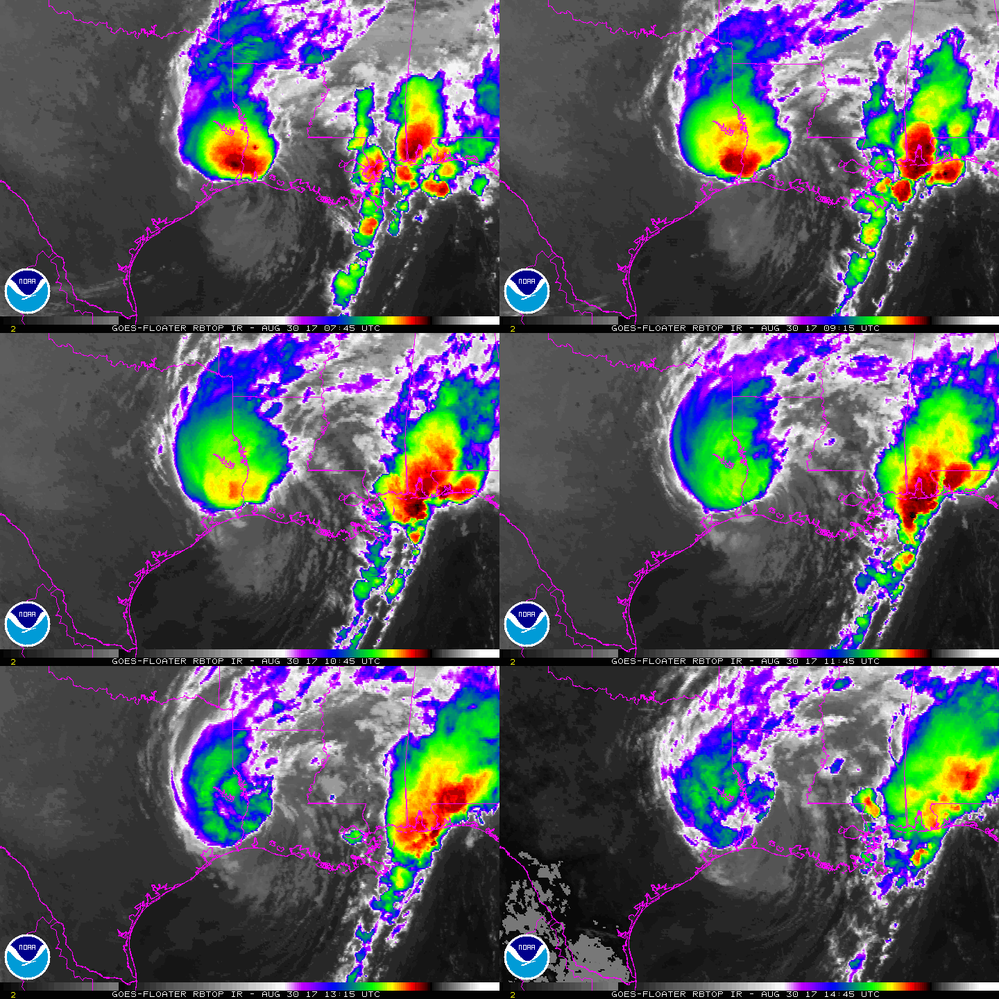
rbtop-animated.gif

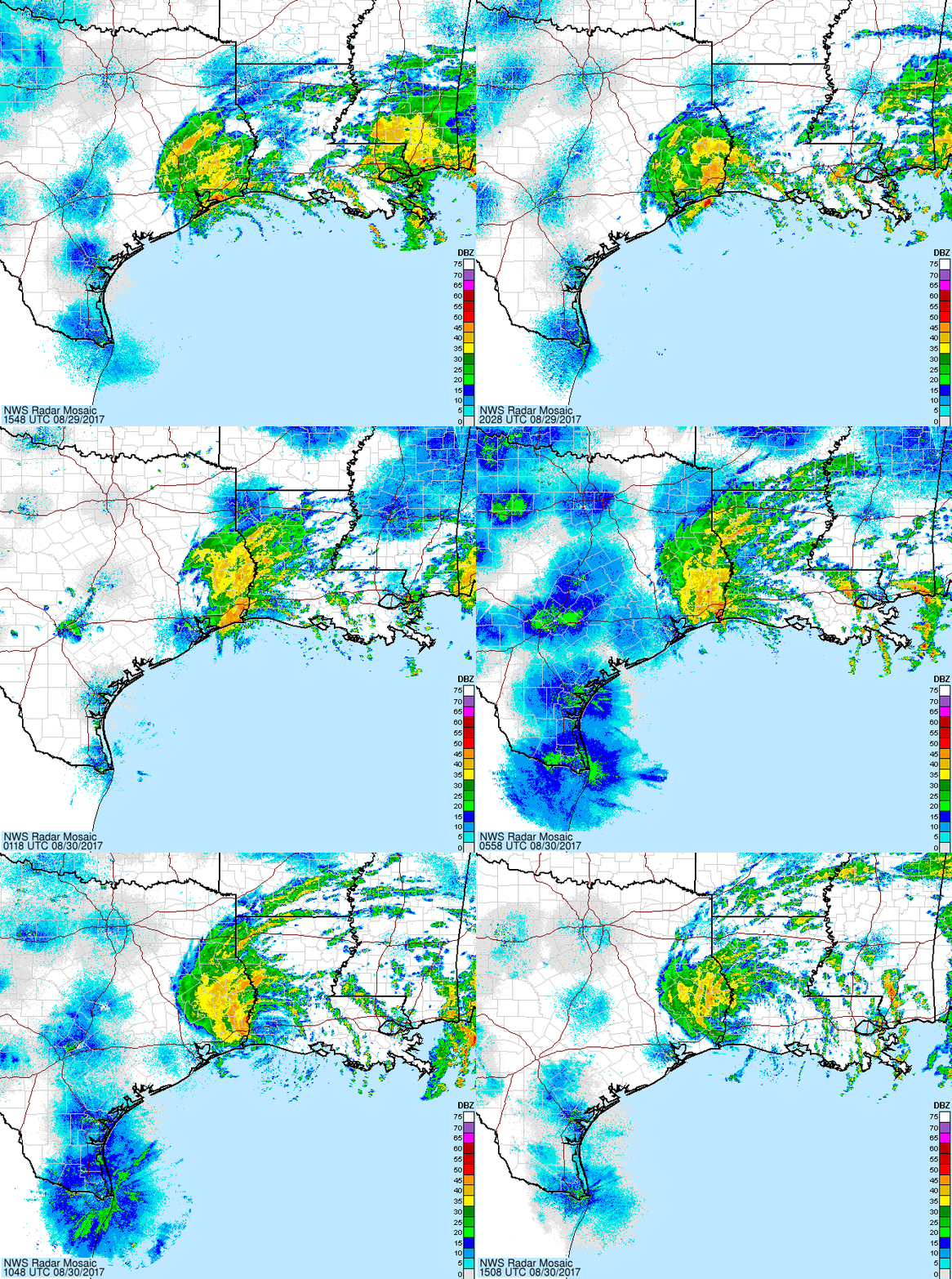
Harvey_25-27Aug17_latest_oneday.gif

霧峰追風者 發表於 2017-8-30 12:02
本帖最後由 霧峰追風者 於 2017-8-30 12:06 編輯

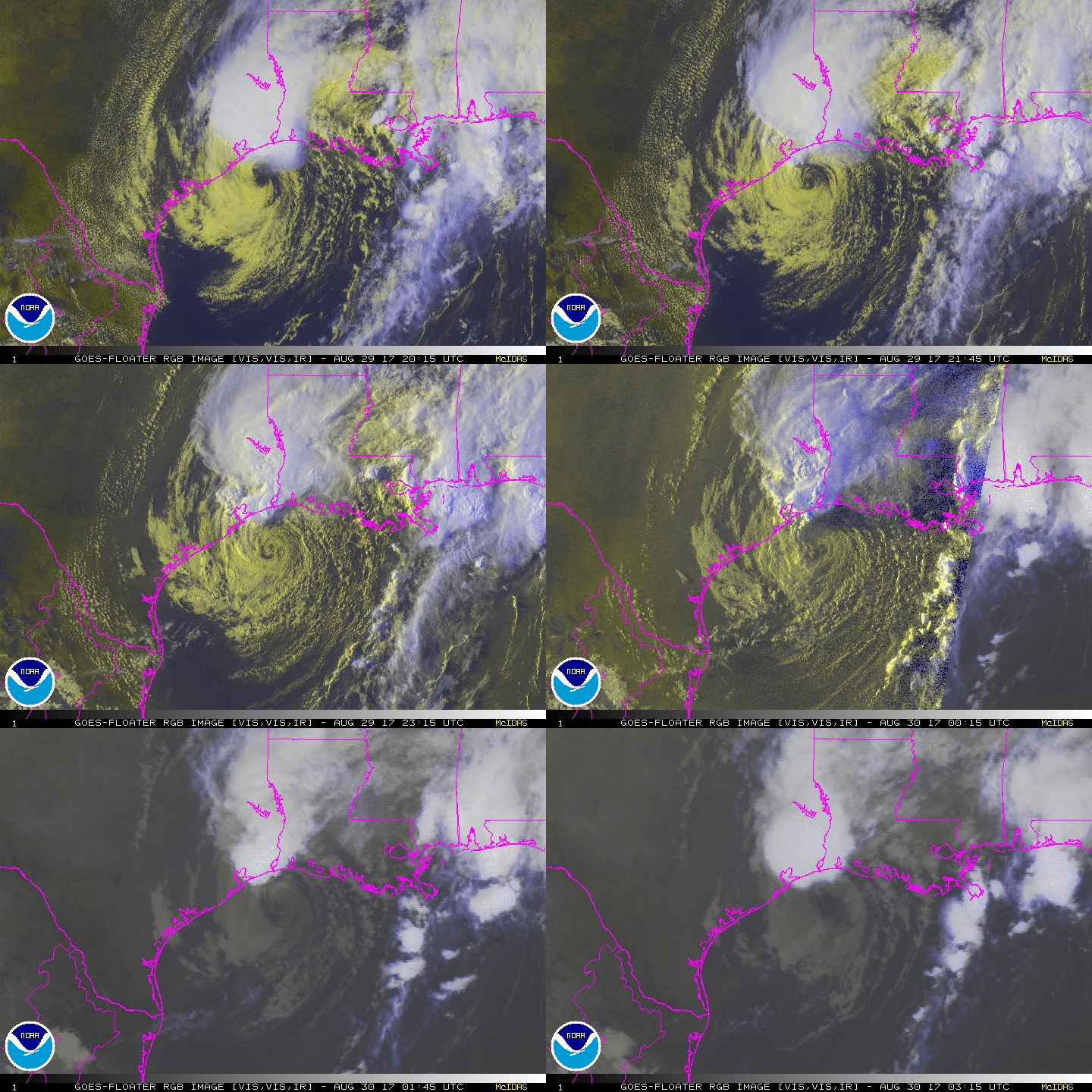
雖然中心已經裸奔,不過北側對流爆不停....二次登陸點略為偏東,預計從路易斯安納州登陸。
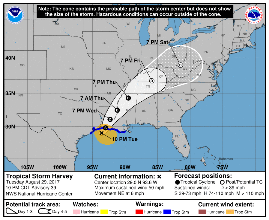
031507_5day_cone_no_line_and_wind.png rgb-animated (12).gif

Meow 發表於 2017-8-30 01:35
水庫潰壩⋯⋯降水破美國歷史紀錄⋯⋯
螢幕快照 2017-08-30 01.23.50.png
https://twitter.com/BrazoriaCounty/status/902539081841827842
21151499_1510527722340594_388972823004501468_n.png

評分

參與人數 2水氣能量 +8 收起 理由
b997755 + 3 淹的好扯
t02436 + 5

查看全部評分

Kujira 發表於 2017-8-29 21:34
蜜露 發表於 2017-8-29 19:49
這次颶風登陸後 , 一開始是風災 .  彷彿梅姬般 .

之後速度減慢 , 影響德克薩斯州範圍從原本的風災  ...

這水淹成這樣真的WTF......

本平台僅供學術討論之用,預報應以氣象局為準

威普網站虛擬主機贊助公司

臺灣第一個天氣類型社群平台 即時天氣資訊、精準颱風動態

線上客服
FB傳送訊息
廣告行銷
精準行銷 物超所值
官方粉專
發佈 快速回復 返回頂部 返回列表