|
|
 krichard2011|2014-4-8 09:50
|
顯示全部樓層
krichard2011|2014-4-8 09:50
|
顯示全部樓層
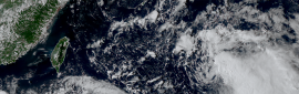
BOM這報升格澳式C3 上看澳式C4
不過過去移動速度0 = =
完全原地不動.....
可見導引氣流非常弱
IDQ20018
TROPICAL CYCLONE TECHNICAL BULLETIN: AUSTRALIA - EASTERN REGION
Issued by BRISBANE TROPICAL CYCLONE WARNING CENTRE
at: 0115 UTC 08/04/2014
Name: Severe Tropical Cyclone Ita
Identifier: 15U
Data At: 0000 UTC
Latitude: 11.8S
Longitude: 153.4E
Location Accuracy: within 20 nm [35 km]
Movement Towards: east [090 deg]
Speed of Movement: 0 knots [0 km/h]
Maximum 10-Minute Wind: 65 knots [120 km/h]
Maximum 3-Second Wind Gust: 90 knots [165 km/h]
Central Pressure: 973 hPa
Radius of 34-knot winds NE quadrant: 70 nm [130 km]
Radius of 34-knot winds SE quadrant: 100 nm [185 km]
Radius of 34-knot winds SW quadrant: 100 nm [185 km]
Radius of 34-knot winds NW quadrant: 70 nm [130 km]
Radius of 48-knot winds NE quadrant: 40 nm [75 km]
Radius of 48-knot winds SE quadrant: 40 nm [75 km]
Radius of 48-knot winds SW quadrant: 40 nm [75 km]
Radius of 48-knot winds NW quadrant: 40 nm [75 km]
Radius of 64-knot winds: 20 nm [35 km]
Radius of Maximum Winds: 20 nm [35 km]
Dvorak Intensity Code: T4.5/4.5/D1.0/24HRS
Pressure of outermost isobar: 1006 hPa
Radius of outermost closed isobar: 200 nm [370 km]
FORECAST DATA
Date/Time : Location : Loc. Accuracy: Max Wind : Central Pressure
[UTC] : degrees : nm [km]: knots[km/h]: hPa
+06: 08/0600: 11.8S 152.9E: 030 [060]: 065 [120]: 976
+12: 08/1200: 11.6S 152.4E: 045 [080]: 070 [130]: 972
+18: 08/1800: 11.6S 151.7E: 055 [105]: 070 [130]: 973
+24: 09/0000: 11.7S 151.1E: 070 [130]: 075 [140]: 968
+36: 09/1200: 12.0S 149.5E: 090 [165]: 080 [150]: 965
+48: 10/0000: 12.5S 147.8E: 110 [200]: 085 [155]: 960
+60: 10/1200: 12.9S 146.5E: 130 [235]: 085 [155]: 959
+72: 11/0000: 13.7S 145.3E: 145 [270]: 090 [165]: 955
+96: 12/0000: 15.1S 143.3E: 190 [355]: 045 [085]: 990
+120: 13/0000: 16.7S 142.9E: 280 [515]: 025 [045]: 1001
REMARKS:
Using EMBD Centre with a 1.1 degree LG surround, yielding a DT of 4.5. MET is
also 4.5, though it is arguable that the 21Z image from 27 hours ago had a LG
eye with a LG surround, though this was a very transient feature at the time.
Now 12 hour-old Ascat data showed numerous values near the centre of at least 50
knots, broadly consistent with the current DT.
TC Ita remains near stationary, trapped between mid level ridges over eastern
Australia and to Ita's east. The mid level ridge over eastern Australia is
expected to ridge zonally out into the southwestern reaches of the Coral Sea
over the next few days, thereby inducing the forecast westward motion. Towards
the end of the week global modelling varies in its treatment of an approaching
upper trough, with some models introducing a low amplitude upper trough and
thereby allowing Ita to move into the Gulf of Carpentaria, whilst other global
models introduce an upper trough of sufficient amplitude that Ita remains in the
Coral Sea or moves over northern Queensland.
Ita lies in a low shear environment with good upper level outflow. The system
is expected to remain in an environment that ordinarily would be expected to be
favourable for development, though allowances have been made for the high
terrain over Papua New Guinea, which may hinder development over the short term. |
本帖子中包含更多資源
您需要 登錄 才可以下載或查看,沒有賬號?立即加入
x
|