開啟輔助訪問
 找回密碼
 立即加入

05L.Earl 登陸墨西哥 逐漸減弱消散

簽到天數: 474 天

[LV.9]以壇為家II

2016-7-29 01:37 | 顯示全部樓層
提示: 作者被禁止或刪除 內容自動屏蔽
回復

使用道具 舉報

簽到天數: 474 天

[LV.9]以壇為家II

劉瑞益@FB|2016-8-1 13:56 | 顯示全部樓層
提示: 作者被禁止或刪除 內容自動屏蔽
回復

使用道具 舉報

簽到天數: 3279 天

[LV.Master]伴壇終老

t02436|2016-8-2 14:29 | 顯示全部樓層
美國海軍已經於昨天10Z發布TCFA
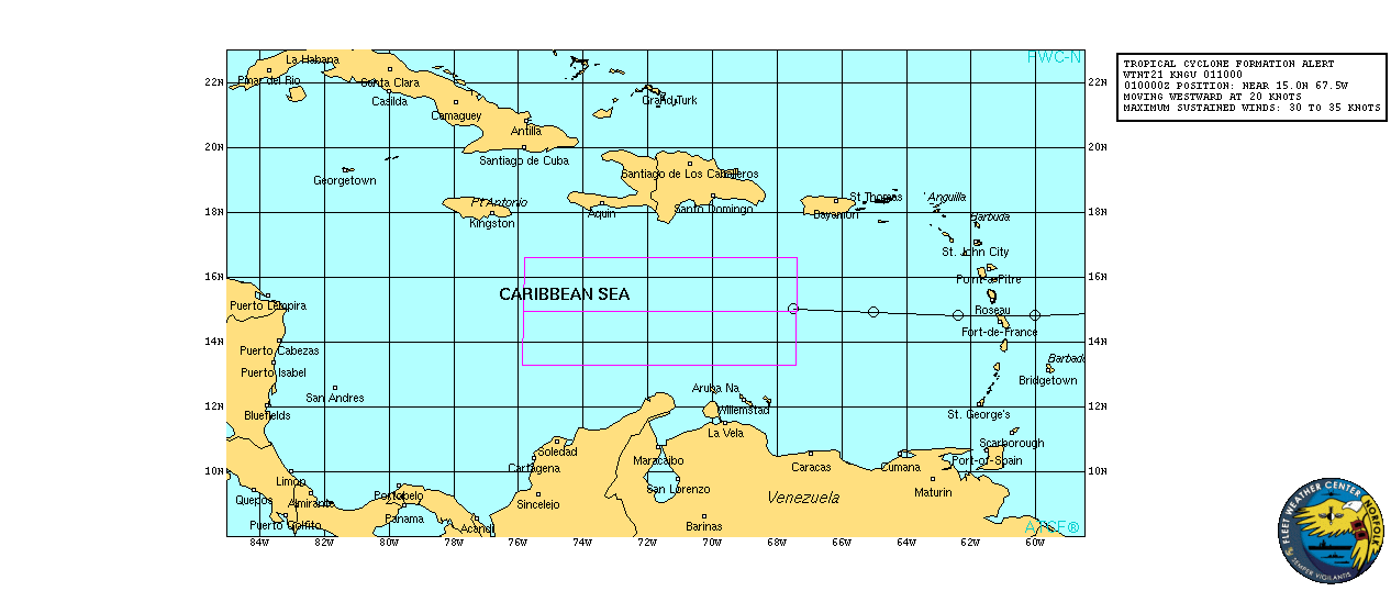
al972016.20160801100156.gif

NHC 00Z持續評價40節,但由於認為系統沒有明顯的閉合環流,所以不予升格05L
97L INVEST 160802 0000  16.6N   75.2W ATL   40  1007
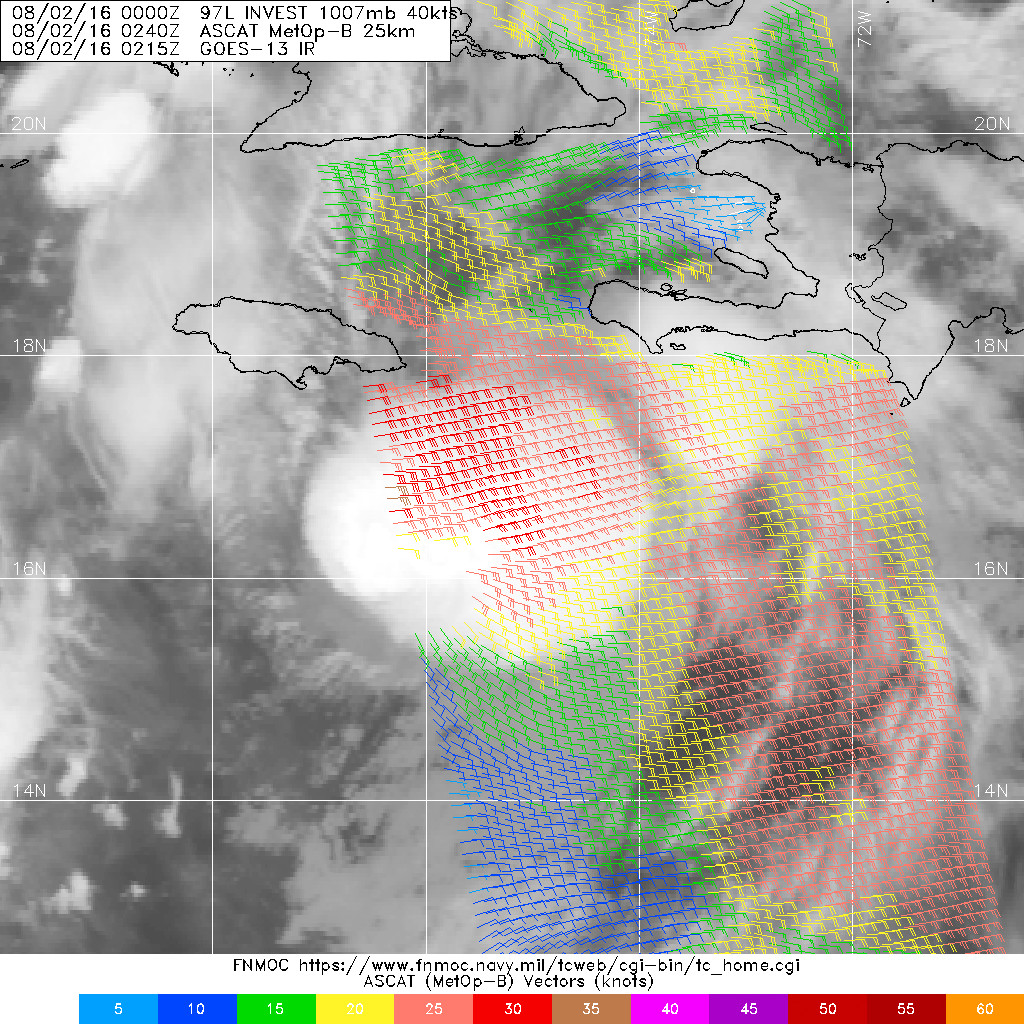
20160802.0240.mtb.ASCAT.wind.97L.INVEST.40kts-1007mb.166N.752W.25km.jpg

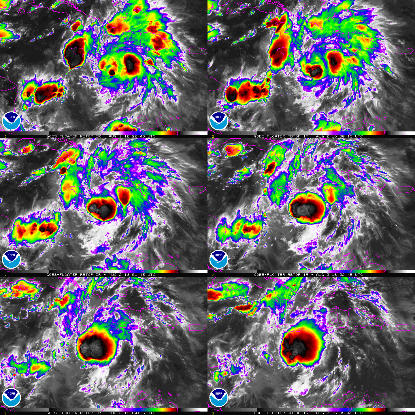
飛機實測將在稍晚正式啟動
1. A strong tropical wave over the central Caribbean Sea, located about
150 miles south-southwest of Kingston, Jamaica, continues to move
quickly westward at about 20 mph. Recent satellite data indicate
that the system is producing winds of 40 to 45 mph, but that it
still appears to lack a closed surface circulation.
Environmental
conditions are expected to be conducive for additional development,
and a tropical storm is likely to form later today.  An Air Force
Reserve Reconnaissance aircraft is scheduled to investigate the
system this morning.
Regardless of development, locally heavy
rainfall and gusty winds, perhaps to tropical storm force, will
continue over portions of Jamaica this morning and reach the Cayman
Islands later today.  Interests in these areas and elsewhere in the
western Caribbean Sea should continue to monitor the progress of
this disturbance.  For additional information, see High Seas
Forecasts issued by the National Weather Service.
* Formation chance through 48 hours...high...80 percent
* Formation chance through 5 days...high...90 percent
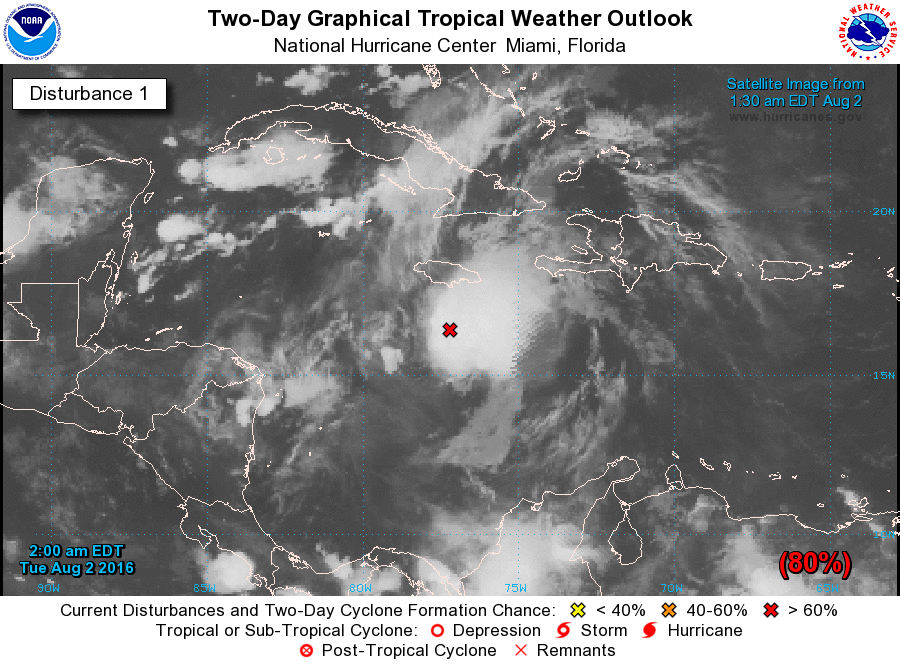
two_atl_2d1.png

000
NOUS42 KNHC 011514
REPRPD
WEATHER RECONNAISSANCE FLIGHTS
CARCAH, NATIONAL HURRICANE CENTER, MIAMI, FL.
1115 AM EDT MON 01 AUGUST 2016
SUBJECT: TROPICAL CYCLONE PLAN OF THE DAY (TCPOD)
         VALID 02/1100Z TO 03/1100Z AUGUST 2016
         TCPOD NUMBER.....16-067

I.  ATLANTIC REQUIREMENTS
    1. SUSPECT AREA....CARIBBEAN SEA
       FLIGHT ONE - TEAL 72             FLIGHT TWO - TEAL 73
       A. 02/1130, 1730Z                A. 02/2330, 03/0530Z
       B. AFXXX 0205A CYCLONE           B. AFXXX 0305A CYCLONE
       C. 02/0715Z                      C. 02/1930Z
       D. 16.1N 79.0W                   D. 16.2N 81.8W
       E. 02/1100Z TO 02/1730Z          E. 02/2300Z TO 03/0530Z
       F. SFC TO 10,000 FT              F. SFC TO 15,000 FT

       FLIGHT THREE - NOAA 43           FLIGHT FOUR - TEAL 74
       A. 03/0930Z                      A. 03/1130, 1730Z
       B. NOAA3 0405A                   B. AFXXX 0505A CYCLONE
       C. 03/0600Z                      C. 03/0800Z
       D. 16.4N 83.9W                   D. 16.6N 84.3W
       E. 03/0900Z TO 03/1200Z          E. 03/1100Z TO 03/1730Z
       F. SFC TO 15,000 FT              F. SFC TO 15,000 FT
rbtop-animated.gif
回復

使用道具 舉報

簽到天數: 3279 天

[LV.Master]伴壇終老

t02436|2016-8-2 23:41 | 顯示全部樓層
稍早疑似有閉合圈出現,NHC正式命名Earl
NHC will initiate advisories on Tropical Storm Earl with a Special Advisory to be issued before noon EDT.

飛機實測持續進行中,目前錄得45節以上風力
recon_AF303-02DDA-INVEST_timeseries.png

recon_AF303-02DDA-INVEST.png

vis-animated.gif

000
WTNT45 KNHC 021557
TCDAT5

TROPICAL STORM EARL SPECIAL DISCUSSION NUMBER   1
NWS NATIONAL HURRICANE CENTER MIAMI FL       AL052016
1200 PM EDT TUE AUG 02 2016

Data from an Air Force reconnaissance plane indicate that the
strong wave we have been tracking for days has developed a closed
circulation center with an estimated pressure of 1001 mb.
On this
basis, advisories on Tropical Storm Earl have been initiated.  This
is the fifth tropical storm of the 2016 hurricane season.

The overall convective pattern was a little less organized this
morning, but recent images indicate that an area of deep convection
is forming near or over the center. The upper-level outflow is not
well established yet in all quadrants due to some shear. Most of
the global models show that the upper-level environment should
become more favorable with less shear. The NHC forecast calls for
some intensification, and Earl is expected to be near hurricane
strength by the time the center approaches the Yucatan peninsula.

Earl has been moving westward rapidly around 19 kt embedded within
very strong easterly flow around the periphery of the Atlantic
subtropical high. The ridge extends westward across the southern
United States, and this pattern should maintain the cyclone
on a general westward track across Belize and Yucatan during the
next couple of days. After that time, a weakened Earl should move
over the southern Bay of Campeche and southern Mexico. The cyclone
should slow down during the next 12 to 24 hours since the steering
currents are expected to be weaker. Most of the dynamical guidance
agree on this scenario, and the NHC forecast very closely follows
the multi-model consensus.


FORECAST POSITIONS AND MAX WINDS

INIT  02/1600Z 16.3N  80.2W   40 KT  45 MPH
12H  03/0000Z 16.3N  82.6W   45 KT  50 MPH
24H  03/1200Z 17.0N  85.2W   50 KT  60 MPH
36H  04/0000Z 17.5N  87.5W   55 KT  65 MPH
48H  04/1200Z 18.0N  90.0W   30 KT  35 MPH...INLAND
72H  05/1200Z 19.2N  94.0W   40 KT  45 MPH...OVER WATER
96H  06/1200Z 20.0N  98.0W   25 KT  30 MPH...INLAND
120H  07/1200Z...DISSIPATED

$$
Forecaster Avila

155812W_sm.gif
回復

使用道具 舉報

簽到天數: 474 天

[LV.9]以壇為家II

劉瑞益@FB|2016-8-4 11:15 | 顯示全部樓層
提示: 作者被禁止或刪除 內容自動屏蔽
回復

使用道具 舉報

簽到天數: 3279 天

[LV.Master]伴壇終老

t02436|2016-8-4 11:15 | 顯示全部樓層
NHC 00Z升格C1,將在稍後登陸貝里斯,橫越猶加敦半島進入坎佩切灣之後有微幅增強的機會。
000
WTNT45 KNHC 040253
TCDAT5

HURRICANE EARL DISCUSSION NUMBER   7
NWS NATIONAL HURRICANE CENTER MIAMI FL       AL052016
1000 PM CDT WED AUG 03 2016

Earl has been under close surveillance by Air Force and NOAA
Hurricane Hunter planes and the Belize Meteorological Service radar
this evening.  The Air Force Hurricane Hunters found peak 700 mb
flight-level winds of 72 kt which converts to a surface wind of 65
kt, and this is used for the advisory intensity.
Belize radar
imagery shows that the eyewall has been fluctuating between an open
and closed structure over the past several hours.
There is little
time left for Earl to strengthen before the center reaches the
coast, and no significant intensification is anticipated before
landfall.  A steady weakening trend will commence after the
tropical cyclone moves inland.  Based on the latest track
guidance, the center is forecast to only barely emerge into the
extreme southern Bay of Campeche on Thursday, and this should limit
reintensification at that time.  Earl is expected to become a
remnant low and dissipate over the high mountains of south-central
Mexico by the weekend or sooner.

Earl continues to move slightly north of due west or 280/13 kt.
The cyclone remains embedded in a well-defined steering flow to the
south of a large and slow-moving mid-tropospheric high pressure
system.  Little change has been made to the previous official
forecast track and the current NHC forecast remains close to the
multi-model consensus.

After landfall, the biggest concern with Earl is rainfall.  Global
models depict the system becoming enveloped within a much
larger-scale cyclonic gyre that will cover much of southern Mexico
in a couple of days.  This weather pattern will likely lead to
copious rains, with isolated precipitation totals of 18 inches
possible.

FORECAST POSITIONS AND MAX WINDS

INIT  04/0300Z 17.4N  87.6W   65 KT  75 MPH
12H  04/1200Z 17.7N  89.3W   50 KT  60 MPH...INLAND
24H  05/0000Z 18.2N  91.4W   30 KT  35 MPH...INLAND
36H  05/1200Z 18.5N  93.5W   25 KT  30 MPH...INLAND
48H  06/0000Z 18.8N  95.1W   30 KT  35 MPH...OVER WATER
72H  07/0000Z 20.0N  98.3W   20 KT  25 MPH...INLAND
96H  08/0000Z...DISSIPATED

$$
Forecaster Pasch

025800W_sm.gif

Earl的第7次飛機實測進行中,目前測得10秒平均飛行層面風速最大72節;10秒平均SFMR海平面風速最大77節。
025730 1730N 08746W 6969 03054 9915 +112 +096 063070 071 077 007 03
025800 1732N 08747W 6970 03063 9925 +113 +082 064071 072 063 005 03

recon_AF301-0705A-EARL_timeseries.png

recon_AF301-0705A-EARL.png

貝里斯雷達與底層,底層風眼已經很明顯了
20160804.0033.f18.91pct91h91v.05L.EARL.65kts.985mb.17.3N.86.9W.100pc.jpg

Earl_3Aug16_Belize.gif

rbtop-animated.gif

回復

使用道具 舉報

簽到天數: 3279 天

[LV.Master]伴壇終老

t02436|2016-8-4 14:42 | 顯示全部樓層
稍早中心已經登陸貝里斯
** WTNT35 KNHC 040556 ***
TCPAT5

BULLETIN
HURRICANE EARL INTERMEDIATE ADVISORY NUMBER   7A
NWS NATIONAL HURRICANE CENTER MIAMI FL       AL052016
100 AM CDT THU AUG 04 2016

...CENTER OF EARL MAKES LANDFALL NEAR BELIZE CITY...


SUMMARY OF 100 AM CDT...0600 UTC...INFORMATION
----------------------------------------------
LOCATION...17.4N 88.3W
ABOUT 5 MI...10 KM SW OF BELIZE CITY BELIZE
MAXIMUM SUSTAINED WINDS...80 MPH...130 KM/H
PRESENT MOVEMENT...W OR 280 DEGREES AT 14 MPH...23 KM/H
MINIMUM CENTRAL PRESSURE...979 MB...28.91 INCHES

Earl_3Aug16_Belize_zoom.gif

NHC於05Z(登陸之前)根據穿心7次的實測結果,將強度提升到70節、979百帕。
** WTNT65 KNHC 040454 ***
TCUAT5

HURRICANE EARL TROPICAL CYCLONE UPDATE
NWS NATIONAL HURRICANE CENTER MIAMI FL       AL052016
1200 AM CDT THU AUG 04 2016

...AIR FORCE HURRICANE HUNTER REPORTS EARL NOW HAS 80 MPH WINDS...

Reports from an Air Force Reserve Hurricane Hunter aircraft indicate
that the maximum sustained winds in Earl have increased to near 80
mph (130 km/h).
The hurricane is expected to make landfall in the
next couple of hours near Belize City, Belize.


SUMMARY OF 1200 AM CDT...0500 UTC...INFORMATION
----------------------------------------------
LOCATION...17.4N 88.0W
ABOUT 15 MI...25 KM ESE OF BELIZE CITY BELIZE
MAXIMUM SUSTAINED WINDS...80 MPH...130 KM/H
PRESENT MOVEMENT...W OR 280 DEGREES AT 14 MPH...22 KM/H
MINIMUM CENTRAL PRESSURE...979 MB...28.91 INCHES

$$
Forecaster Beven

recon_AF301-0705A-EARL.png

點評

實測有Cat.1上限潛力 ,和妮妲差不多強  發表於 2016-8-4 20:05
回復

使用道具 舉報

簽到天數: 582 天

[LV.9]以壇為家II

蜜露|2016-8-5 21:48 | 顯示全部樓層


登陸了貝里斯 , 當地帶來一些樹木頃倒和積水

下載 (1).jpg


下載.jpg

回復

使用道具 舉報

12下一頁
快速回覆
您需要登錄後才可以回帖 登錄 | 立即加入

本版積分規則

劉瑞益@FB

    主題

    帖子

    104萬

    積分

    13級[一級颶風]

    Rank: 13Rank: 13Rank: 13Rank: 13

13級[一級颶風]

發訊息

本平台僅供學術討論之用,預報應以氣象局為準

威普網站虛擬主機贊助公司

臺灣第一個天氣類型社群平台 即時天氣資訊、精準颱風動態

線上客服
FB傳送訊息
廣告行銷
精準行銷 物超所值
官方粉專
發佈 快速回復 返回頂部 返回列表