開啟輔助訪問
 找回密碼
 立即加入

01L.Ana 中心登陸 逐漸減弱

簽到天數: 3280 天

[LV.Master]伴壇終老

2015-5-6 15:54 | 顯示全部樓層
本帖最後由 t02436 於 2015-5-14 00:43 編輯

  熱帶風暴  
編號:01 L
名稱:Ana


  基本資料  
擾動編號日期:2015 05 06 15
命名日期  :2015 05 08 11
撤編日期  :2015 05 13 18
登陸地點  :美國 南卡羅來納州

  巔峰時期資料  
近中心最強風速 / 海平面最低氣壓
國家颶風中心 (NHC) : 50 kts ( TS )
海平面最低氣壓         :998 百帕

  過去路徑圖  


  討論帖圖片  
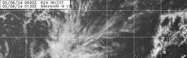
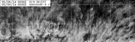
AL, 90, 2015050606,   , BEST,   0, 265N,  790W,  25, 1016, LO,  34, NEQ,    0,    0,    0,    0, 1018,  120,  50,   0,   0,   L,   0,    ,   0,   0,     INVEST, M,  0,    ,    0,    0,    0,    0, genesis-num, 001,

90L.INVEST.25kts.1015mb.26.8N.79.4W


-----------------------------------------------------------------------------------------------
NHC : Low
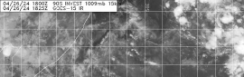
SPECIAL TROPICAL WEATHER OUTLOOK
NWS NATIONAL HURRICANE CENTER MIAMI FL
1000 AM EDT TUE MAY 5 2015

For the North Atlantic...Caribbean Sea and the Gulf of Mexico:

1. A large area of disorganized showers and thunderstorms extending
from the northwestern Caribbean Sea across Cuba, southern Florida,
and the Bahamas is associated with an upper-level trough and a weak
surface trough. An area of low pressure is expected to form in
association with this disturbance during the next day or two. The
low could gradually acquire subtropical characteristics over the
next few days while it moves generally northward at a slow forward
speed. For additional information on this system, see High Seas
Forecasts issued by the National Weather Service. The next Special
Tropical Weather Outlook will be issued on this system by 11 AM EDT
Wednesday.
* Formation chance through 48 hours...low...20 percent
* Formation chance through 5 days...medium...40 percent


以上資料來自 : NHC、颱風論壇整理製作

本帖子中包含更多資源

您需要 登錄 才可以下載或查看,沒有賬號?立即加入

x

點評

alu
看樣子北半球熱鬧的颱風季要開始了  發表於 2015-5-6 16:38
回復

使用道具 舉報

簽到天數: 3280 天

[LV.Master]伴壇終老

t02436|2015-5-10 20:46 | 顯示全部樓層
Ana於台灣時間傍晚六點登陸南卡羅來納州。
...CENTER OF TROPICAL STORM ANA MAKES LANDFALL...
NOAA Doppler radar data and nearby surface observations indicate
that the center of Tropical Storm Ana made landfall at 0600 AM
EDT...1000 UTC...along the South Carolina coast almost midway
between Myrtle Beach and North Myrtle Beach.


本帖子中包含更多資源

您需要 登錄 才可以下載或查看,沒有賬號?立即加入

x
回復

使用道具 舉報

簽到天數: 3739 天

[LV.Master]伴壇終老

甜心|2015-5-10 15:30 | 顯示全部樓層
回復

使用道具 舉報

簽到天數: 3280 天

[LV.Master]伴壇終老

t02436|2015-5-10 13:52 | 顯示全部樓層
Ana現在位於南卡羅來納州南方近海
即將登陸


Wilmington站雷達動畫(自05/09 0000Z~05/10 0546Z)


05/09 Terra

本帖子中包含更多資源

您需要 登錄 才可以下載或查看,沒有賬號?立即加入

x
回復

使用道具 舉報

簽到天數: 588 天

[LV.9]以壇為家II

Meow|2015-5-9 20:33 | 顯示全部樓層
5月8日的副熱帶風暴Ana


https://commons.wikimedia.org/wiki/File:Ana_May_8_2015_1810z.jpg

另外上一報已經判定轉化為熱帶風暴了。

本帖子中包含更多資源

您需要 登錄 才可以下載或查看,沒有賬號?立即加入

x
回復

使用道具 舉報

簽到天數: 1989 天

[LV.Master]伴壇終老

ben811018|2015-5-9 00:22 | 顯示全部樓層


撇開環流不是很對稱,ANA也滿美的阿XDD~

本帖子中包含更多資源

您需要 登錄 才可以下載或查看,沒有賬號?立即加入

x
回復

使用道具 舉報

簽到天數: 1989 天

[LV.Master]伴壇終老

ben811018|2015-5-8 12:28 | 顯示全部樓層

升格01L,第一報!


本帖子中包含更多資源

您需要 登錄 才可以下載或查看,沒有賬號?立即加入

x

點評

路徑圖還是以NHC為準吧  發表於 2015-5-8 17:54
回復

使用道具 舉報

簽到天數: 3280 天

[LV.Master]伴壇終老

t02436|2015-5-8 12:01 | 顯示全部樓層
NHC升格副熱帶風暴並命名Ana
WTNT41 KNHC 080233
TCDAT1

SUBTROPICAL STORM ANA DISCUSSION NUMBER   1
NWS NATIONAL HURRICANE CENTER MIAMI FL       AL012015
1100 PM EDT THU MAY 07 2015

Satellite imagery shows some increase in deep convection this
evening, and the low pressure system off the southeast U.S. coast
is now being designated as a subtropical storm.  Based on adjusted
SFMR winds from a hurricane hunter aircraft that has been
investigating the system, the current intensity is set at 40
kt.  Data from the aircraft also show that the radius of maximum
winds has decreased somewhat from earlier today, but at 80 n mi it
is still too large to justify classifying Ana as a tropical cyclone
at this time.  Since there has been more deep convection occurring
near the center over the past several hours, it is becoming more
likely that Ana will make the transition into a tropical storm
within the next day or so.  The storm should remain situated near or
over the Gulf Stream for the next 24-36 hours, which would allow for
some slight strengthening.  Later in the period, as the cyclone
approaches the coast, weakening is expected due to the influence of
cooler shelf waters.

The system has not moved much over the past 24 hours and the
initial motion estimate is 350/2.  Ana is likely to remain located
to the south of a stubborn mid-tropospheric blocking pattern for the
next 48 hours or so.  Global models show the block breaking down
over the weekend, which should allow Ana to move inland over the
southeastern U.S. Near the end of the forecast period, the system
should accelerate northeastward in the flow ahead of a broad trough.
The official track forecast is close to the dynamical model
consensus.

We appreciate the assistance of the Air Force Hurricane Hunters for
providing valuable observations, given their limited resources
prior to the start of the regular Atlantic Hurricane Season.

Note that the name Ana is pronounced AH-nah.

FORECAST POSITIONS AND MAX WINDS

INIT  08/0300Z 31.5N  77.6W   40 KT  45 MPH
12H  08/1200Z 31.6N  77.7W   45 KT  50 MPH
24H  09/0000Z 31.7N  77.8W   45 KT  50 MPH
36H  09/1200Z 31.9N  78.0W   40 KT  45 MPH
48H  10/0000Z 32.3N  78.6W   35 KT  40 MPH
72H  11/0000Z 33.4N  79.3W   30 KT  35 MPH...INLAND
96H  12/0000Z 36.1N  77.8W   25 KT  30 MPH...POST-TROP/INLAND
120H  13/0000Z 41.0N  71.5W   25 KT  30 MPH...POST-TROP/REMNT LOW

$$
Forecaster Pasch


本帖子中包含更多資源

您需要 登錄 才可以下載或查看,沒有賬號?立即加入

x
回復

使用道具 舉報

12下一頁
快速回覆
您需要登錄後才可以回帖 登錄 | 立即加入

本版積分規則

本平台僅供學術討論之用,預報應以氣象局為準

威普網站虛擬主機贊助公司

臺灣第一個天氣類型社群平台 即時天氣資訊、精準颱風動態

線上客服
FB傳送訊息
廣告行銷
精準行銷 物超所值
官方粉專
發佈 快速回復 返回頂部 返回列表