開啟輔助訪問
 找回密碼
 立即加入

22S.Marian 曾短暫增強至澳式C4 逐漸南下減弱

簽到天數: 1650 天

[LV.Master]伴壇終老

老農民版夜神月|2021-2-28 02:43 | 顯示全部樓層
BoM18Z仍維持60節,其將預測升格澳3的時間推遲為+12H(28/06Z)
IDW27600
TROPICAL CYCLONE TECHNICAL BULLETIN: AUSTRALIA - WESTERN REGION
Issued by AUSTRALIAN BUREAU OF METEOROLOGY TROPICAL CYCLONE WARNING CENTRE
at: 1831 UTC 27/02/2021
Name: Tropical Cyclone Marian
Identifier: 15U
Data At: 1800 UTC
Latitude: 16.4S
Longitude: 92.6E
Location Accuracy: within 20 nm [35 km]
Movement Towards: southwest [233 deg]
Speed of Movement: 9 knots [17 km/h]
Maximum 10-Minute Wind: 60 knots [110 km/h]
Maximum 3-Second Wind Gust: 85 knots [155 km/h]
Central Pressure: 976 hPa
Radius of 34-knot winds NE quadrant: 120 nm [220 km]
Radius of 34-knot winds SE quadrant: 100 nm [185 km]
Radius of 34-knot winds SW quadrant: 130 nm [240 km]
Radius of 34-knot winds NW quadrant: 120 nm [220 km]
Radius of 48-knot winds NE quadrant: 40 nm [75 km]
Radius of 48-knot winds SE quadrant: 40 nm [75 km]
Radius of 48-knot winds SW quadrant: 50 nm [95 km]
Radius of 48-knot winds NW quadrant: 50 nm [95 km]
Radius of 64-knot winds:
Radius of Maximum Winds: 30 nm [55 km]
Dvorak Intensity Code: T4.0/4.0/D0.5/24HRS STT:S0.0/06HRS
Pressure of outermost isobar: 1004 hPa
Radius of outermost closed isobar: 300 nm [555 km]
FORECAST DATA
Date/Time    : Location    : Loc. Accuracy: Max Wind   : Central Pressure
[UTC]        : degrees     :      nm  [km]: knots[km/h]: hPa
+06:  28/0000: 16.8S  92.1E:     035 [065]:  060  [110]:  975
+12:  28/0600: 17.1S  91.6E:     045 [080]:  065  [120]:  973
+18:  28/1200: 17.4S  91.2E:     050 [090]:  070  [130]:  971
+24:  28/1800: 17.6S  90.7E:     050 [095]:  070  [130]:  971
+36:  01/0600: 18.0S  90.0E:     055 [105]:  075  [140]:  967
+48:  01/1800: 18.3S  89.6E:     070 [130]:  075  [140]:  962
+60:  02/0600: 18.4S  89.8E:     085 [155]:  070  [130]:  967
+72:  02/1800: 18.6S  90.7E:     100 [185]:  065  [120]:  973
+96:  03/1800: 19.7S  93.4E:     135 [255]:  055  [100]:  981
+120: 04/1800: 21.4S  95.8E:     180 [335]:  050  [095]:  983
IDW60280.png 20210227.1810.himawari-8.ir.22S.MARIAN.65kts.979mb.16.2S.93.3E.100pc.jpg
20210227.1508.metopb.89rgb.22S.MARIAN.65kts.979mb.16.2S.93.3E.090pc.jpg
回復

使用道具 舉報

簽到天數: 483 天

[LV.9]以壇為家II

dom|2021-2-27 23:12 | 顯示全部樓層
高層持續無法清空,風切頗強,兩機構強度維持,BoM預測下報增強為澳式C3 0930d0160924ab18fa32d57c22fae6cd7b890b2e.jpg 8e348535e5dde71187f677bdb0efce1b9d16612e.jpg wgmssht.GIF IDW60280.png 螢幕快照 2021-02-27 下午11.03.51.png 60919f3df8dcd100f464c96a658b4710b8122f52.jpg.gif
回復

使用道具 舉報

簽到天數: 1650 天

[LV.Master]伴壇終老

老農民版夜神月|2021-2-27 09:27 | 顯示全部樓層
而BoM的00Z則是將定強從18Z的50節提升至60節(澳式C2上限)随時有可能升格澳式C3(三級強熱帶氣旋)
IDW27600
TROPICAL CYCLONE TECHNICAL BULLETIN: AUSTRALIA - WESTERN REGION
Issued by AUSTRALIAN BUREAU OF METEOROLOGY TROPICAL CYCLONE WARNING CENTRE
at: 0058 UTC 27/02/2021
Name: Tropical Cyclone Marian
Identifier: 15U
Data At: 0000 UTC
Latitude: 14.8S
Longitude: 95.0E
Location Accuracy: within 20 nm [35 km]
Movement Towards: west southwest [249 deg]
Speed of Movement: 8 knots [15 km/h]
Maximum 10-Minute Wind: 60 knots [110 km/h]
Maximum 3-Second Wind Gust: 85 knots [155 km/h]
Central Pressure: 978 hPa
Radius of 34-knot winds NE quadrant: 100 nm [185 km]
Radius of 34-knot winds SE quadrant: 100 nm [185 km]
Radius of 34-knot winds SW quadrant: 140 nm [260 km]
Radius of 34-knot winds NW quadrant: 140 nm [260 km]
Radius of 48-knot winds NE quadrant: 40 nm [75 km]
Radius of 48-knot winds SE quadrant: 40 nm [75 km]
Radius of 48-knot winds SW quadrant: 70 nm [130 km]
Radius of 48-knot winds NW quadrant: 70 nm [130 km]
Radius of 64-knot winds:
Radius of Maximum Winds: 35 nm [65 km]
Dvorak Intensity Code: T4.0/4.0/D1.0/24HRS STT: D0.5/0,6HRS
Pressure of outermost isobar: 1002 hPa
Radius of outermost closed isobar: 240 nm [445 km]
FORECAST DATA
Date/Time    : Location    : Loc. Accuracy: Max Wind   : Central Pressure
[UTC]        : degrees     :      nm  [km]: knots[km/h]: hPa
+06:  27/0600: 15.1S  94.2E:     040 [075]:  060  [110]:  978
+12:  27/1200: 15.5S  93.4E:     055 [105]:  060  [110]:  978
+18:  27/1800: 15.9S  92.8E:     070 [130]:  060  [110]:  978
+24:  28/0000: 16.3S  92.3E:     080 [150]:  070  [130]:  974
+36:  28/1200: 16.9S  91.3E:     105 [190]:  070  [130]:  969
+48:  01/0000: 17.4S  90.6E:     120 [220]:  070  [130]:  969
+60:  01/1200: 17.9S  90.1E:     140 [255]:  070  [130]:  968
+72:  02/0000: 18.1S  90.3E:     150 [280]:  070  [130]:  968
+96:  03/0000: 18.9S  92.5E:     225 [415]:  060  [110]:  975
+120: 04/0000: 20.8S  95.4E:     285 [525]:  055  [100]:  978
REMARKS:
At 21Z and 00Z no clear-cut DVK pattern. Unable to use embedded centre at 21Z
due to constraints, and curved banding no longer evident.  Applying a shear
pattern yields a DT of 3.5. Applying a curved band analysis to microwave at 22Z
would give wrap of around 0.8, consistent with T3.5. Applying an Embedded Centre
pattern at 00Z [first allowable time under constraints] yields a T5.0
[discounted]. ADT has been steady at CI 3.7-3.8 overnight.  SATCON at 1527
estimated 68 knots 1-min mean with ADT at 61 knots and CIMSS AMSU algorithm at
78 knots. AMSR2 pass at 1843Z indicated a small area of hurricane force winds in
the southwest quadrant. Final intensity estimate set at 60 knots 10-min mean.

Strong divergence in the southwest quadrant and moderate divergence in NW and SE
quadrants may be aided by split flow at high levels and a shear profile with
much of the shear at high levels.

The system has been tracking at a around 17 knots but has slowed overnight as it
intensified and the mid-level ridge weakens, and is now moving at a speed of
around 8 knots, consistent with NWP guidance.

CIMSS analysed shear at 22 knots from the east at 26/1800 UTC, consistent with
previous analysis and appearance in satellite imagery. Shear appears to be
mostly in the high levels with a noticeable shift in winds from 300hPa to
200hPa. The shear is expected to persist in the short term and dry air can be
seen wrapping around to the north and northeast of the system in animated TPW. A
strengthening trend is forecast that is slightly less than normal due to the
environment and large size

SST's are cooler to the south, with sub 26 degrees south of about 18S. This
could limit development on Monday and then assist in the system weakening as it
moves further south. The circulation is expected to remain at TC strength over
open waters for the next 5-7 days.

Copyright Commonwealth of Australia
==
The next bulletin for this system will be issued by: 27/0730 UTC.

IDW60280 (11).png ir_lalo-animated (11).gif

bd_lalo-animated (2).gif rb_lalo-animated (5).gif
回復

使用道具 舉報

簽到天數: 1650 天

[LV.Master]伴壇終老

老農民版夜神月|2021-2-27 08:57 | 顯示全部樓層
本帖最後由 老農民版夜神月 於 2021-2-27 09:15 編輯

JTWC升格C1
22S MARIAN 210227 0000 15.0S 94.7E SHEM 65 974

20210227.0020.himawari-8.ir.22S.MARIAN.65kts.974mb.15S.94.7E.100pc.jpg 20210226.2138.f15.85rgb.22S.MARIAN.60kts.985mb.14.6S.95.5E.080pc.jpg 20210226.2138.f15.85h.22S.MARIAN.60kts.985mb.14.6S.95.5E.080pc.jpg 20210226.1845.gw1.89pct89h89v.22S.MARIAN.60kts.985mb.14.6S.95.5E.78pc.jpg
回復

使用道具 舉報

簽到天數: 1650 天

[LV.Master]伴壇終老

老農民版夜神月|2021-2-27 03:20 | 顯示全部樓層
BoM當前定強50節,新報持續維持上望70節的預測
IDW27600
TROPICAL CYCLONE TECHNICAL BULLETIN: AUSTRALIA - WESTERN REGION
Issued by AUSTRALIAN BUREAU OF METEOROLOGY TROPICAL CYCLONE WARNING CENTRE
at: 1855 UTC 26/02/2021
Name: Tropical Cyclone Marian
Identifier: 15U
Data At: 1800 UTC
Latitude: 14.4S
Longitude: 95.5E
Location Accuracy: within 20 nm [35 km]
Movement Towards: west [272 deg]
Speed of Movement: 16 knots [31 km/h]
Maximum 10-Minute Wind: 50 knots [95 km/h]
Maximum 3-Second Wind Gust: 70 knots [130 km/h]
Central Pressure: 987 hPa
Radius of 34-knot winds NE quadrant: 120 nm [220 km]
Radius of 34-knot winds SE quadrant: 130 nm [240 km]
Radius of 34-knot winds SW quadrant: 130 nm [240 km]
Radius of 34-knot winds NW quadrant: 100 nm [185 km]
Radius of 48-knot winds NE quadrant: 50 nm [95 km]
Radius of 48-knot winds SE quadrant: 50 nm [95 km]
Radius of 48-knot winds SW quadrant: 50 nm [95 km]
Radius of 48-knot winds NW quadrant: 50 nm [95 km]
Radius of 64-knot winds:
Radius of Maximum Winds: 35 nm [65 km]
Dvorak Intensity Code: T3.5/3.5/D1.0/24HRS STT:S0.0/06HRS
Pressure of outermost isobar: 1002 hPa
Radius of outermost closed isobar: 240 nm [445 km]
FORECAST DATA
Date/Time    : Location    : Loc. Accuracy: Max Wind   : Central Pressure
[UTC]        : degrees     :      nm  [km]: knots[km/h]: hPa
+06:  27/0000: 14.7S  94.3E:     040 [070]:  055  [100]:  982
+12:  27/0600: 14.9S  93.5E:     045 [090]:  055  [100]:  981
+18:  27/1200: 15.3S  92.7E:     050 [095]:  060  [110]:  978
+24:  27/1800: 15.8S  92.1E:     055 [100]:  060  [110]:  978
+36:  28/0600: 16.5S  91.0E:     060 [110]:  070  [130]:  970
+48:  28/1800: 17.0S  90.2E:     075 [140]:  070  [130]:  969
+60:  01/0600: 17.5S  89.6E:     090 [165]:  070  [130]:  969
+72:  01/1800: 17.8S  89.4E:     100 [185]:  070  [130]:  968
+96:  02/1800: 18.5S  91.1E:     135 [250]:  060  [110]:  974
+120: 03/1800: 20.2S  93.9E:     185 [345]:  055  [100]:  978
REMARKS:
Tropical Cyclone Marian [15U] has maintained intensity at category 2.

Dvorak analysis of 3.5 based upon 0.9 wrap. MET/PAT concur. ADT has plateaued at
3.7.
An ASCAT pass at 15:31UTC indicated very small patches of 50 kts winds to the
northeast and southwest of the system. Intensity set to 50 knots.

The mid-level ridge to the south continues to dominate the steering with a WSW
motion forecast although on Saturday the motion will slow as the system deepens
and the steering ridge weakens in response to a developing mid-latitude trough
to the southeast off southern Western Australia. By late Monday [1 March] the
slow moving system should start to track to the southeast and accelerate
somewhat owing to an approaching mid-latitude trough but remain well west of the
Australian mainland.

The analysed shear [CIMSS] has decreased to moderate to high, partially offset
by good upper divergence to the southwest of the system. The shear is expected
to persist and dry air can be seen wrapping around to the north and northeast of
the system in animated TPW. A strengthening trend is forecast which is slightly
less than normal due to the environment and large size.

SST's are cooler to the south, with sub 26 degrees south of about 18S. This
could limit development on Monday and then assist in the system weakening as it
moves further south. The circulation is expected to remain at TC strength over
open waters for the next 5-7 days.

Copyright Commonwealth of Australia
==
The next bulletin for this system will be issued by: 27/0130 UTC.

IDW60280.png MARIAN.png
22S_gefs_latest.png
回復

使用道具 舉報

簽到天數: 1650 天

[LV.Master]伴壇終老

老農民版夜神月|2021-2-27 03:12 | 顯示全部樓層
ASCAT15Z最新風場
LATEST.jpg LATEST01.jpg
20210226.1840.himawari-8.ir.22S.MARIAN.60kts.985mb.14.5S.95.7E.100pc.jpg
回復

使用道具 舉報

簽到天數: 483 天

[LV.9]以壇為家II

dom|2021-2-26 23:11 | 顯示全部樓層
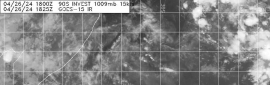
JTWC12Z定強60KT,調高上望至C2(85KT)
WTXS31 PGTW 261500
MSGID/GENADMIN/JOINT TYPHOON WRNCEN PEARL HARBOR HI//
SUBJ/TROPICAL CYCLONE 22S (MARIAN) WARNING NR 002//
RMKS/
1. TROPICAL CYCLONE 22S (MARIAN) WARNING NR 002   
   01 ACTIVE TROPICAL CYCLONE IN SOUTHIO
   MAX SUSTAINED WINDS BASED ON ONE-MINUTE AVERAGE
   WIND RADII VALID OVER OPEN WATER ONLY
    ---
   WARNING POSITION:
   261200Z --- NEAR 14.8S 97.0E
     MOVEMENT PAST SIX HOURS - 260 DEGREES AT 15 KTS
     POSITION ACCURATE TO WITHIN 020 NM
     POSITION BASED ON CENTER LOCATED BY SATELLITE
   PRESENT WIND DISTRIBUTION:
   MAX SUSTAINED WINDS - 060 KT, GUSTS 075 KT
   WIND RADII VALID OVER OPEN WATER ONLY
   RADIUS OF 050 KT WINDS - 045 NM NORTHEAST QUADRANT
                            080 NM SOUTHEAST QUADRANT
                            065 NM SOUTHWEST QUADRANT
                            040 NM NORTHWEST QUADRANT
   RADIUS OF 034 KT WINDS - 105 NM NORTHEAST QUADRANT
                            170 NM SOUTHEAST QUADRANT
                            155 NM SOUTHWEST QUADRANT
                            075 NM NORTHWEST QUADRANT
   REPEAT POSIT: 14.8S 97.0E
    ---
   FORECASTS:
   12 HRS, VALID AT:
   270000Z --- 15.3S 94.5E
   MAX SUSTAINED WINDS - 065 KT, GUSTS 080 KT
   WIND RADII VALID OVER OPEN WATER ONLY
   RADIUS OF 064 KT WINDS - 000 NM NORTHEAST QUADRANT
                            025 NM SOUTHEAST QUADRANT
                            000 NM SOUTHWEST QUADRANT
                            000 NM NORTHWEST QUADRANT
   RADIUS OF 050 KT WINDS - 050 NM NORTHEAST QUADRANT
                            110 NM SOUTHEAST QUADRANT
                            090 NM SOUTHWEST QUADRANT
                            040 NM NORTHWEST QUADRANT
   RADIUS OF 034 KT WINDS - 090 NM NORTHEAST QUADRANT
                            220 NM SOUTHEAST QUADRANT
                            190 NM SOUTHWEST QUADRANT
                            040 NM NORTHWEST QUADRANT
   VECTOR TO 24 HR POSIT: 250 DEG/ 08 KTS
    ---
   24 HRS, VALID AT:
   271200Z --- 15.8S 92.9E
   MAX SUSTAINED WINDS - 070 KT, GUSTS 085 KT
   WIND RADII VALID OVER OPEN WATER ONLY
   RADIUS OF 064 KT WINDS - 025 NM NORTHEAST QUADRANT
                            030 NM SOUTHEAST QUADRANT
                            030 NM SOUTHWEST QUADRANT
                            000 NM NORTHWEST QUADRANT
   RADIUS OF 050 KT WINDS - 050 NM NORTHEAST QUADRANT
                            090 NM SOUTHEAST QUADRANT
                            080 NM SOUTHWEST QUADRANT
                            040 NM NORTHWEST QUADRANT
   RADIUS OF 034 KT WINDS - 090 NM NORTHEAST QUADRANT
                            180 NM SOUTHEAST QUADRANT
                            150 NM SOUTHWEST QUADRANT
                            060 NM NORTHWEST QUADRANT
   VECTOR TO 36 HR POSIT: 240 DEG/ 06 KTS
    ---
   36 HRS, VALID AT:
   280000Z --- 16.4S 91.7E
   MAX SUSTAINED WINDS - 075 KT, GUSTS 090 KT
   WIND RADII VALID OVER OPEN WATER ONLY
   RADIUS OF 064 KT WINDS - 030 NM NORTHEAST QUADRANT
                            035 NM SOUTHEAST QUADRANT
                            030 NM SOUTHWEST QUADRANT
                            030 NM NORTHWEST QUADRANT
   RADIUS OF 050 KT WINDS - 060 NM NORTHEAST QUADRANT
                            080 NM SOUTHEAST QUADRANT
                            070 NM SOUTHWEST QUADRANT
                            050 NM NORTHWEST QUADRANT
   RADIUS OF 034 KT WINDS - 100 NM NORTHEAST QUADRANT
                            160 NM SOUTHEAST QUADRANT
                            140 NM SOUTHWEST QUADRANT
                            070 NM NORTHWEST QUADRANT
   VECTOR TO 48 HR POSIT: 235 DEG/ 05 KTS
    ---
   EXTENDED OUTLOOK:
   48 HRS, VALID AT:
   281200Z --- 17.0S 90.8E
   MAX SUSTAINED WINDS - 080 KT, GUSTS 100 KT
   WIND RADII VALID OVER OPEN WATER ONLY
   RADIUS OF 064 KT WINDS - 030 NM NORTHEAST QUADRANT
                            000 NM SOUTHEAST QUADRANT
                            035 NM SOUTHWEST QUADRANT
                            040 NM NORTHWEST QUADRANT
   RADIUS OF 050 KT WINDS - 050 NM NORTHEAST QUADRANT
                            060 NM SOUTHEAST QUADRANT
                            070 NM SOUTHWEST QUADRANT
                            070 NM NORTHWEST QUADRANT
   RADIUS OF 034 KT WINDS - 080 NM NORTHEAST QUADRANT
                            090 NM SOUTHEAST QUADRANT
                            130 NM SOUTHWEST QUADRANT
                            130 NM NORTHWEST QUADRANT
   VECTOR TO 72 HR POSIT: 225 DEG/ 04 KTS
    ---
   72 HRS, VALID AT:
   011200Z --- 18.0S 89.7E
   MAX SUSTAINED WINDS - 085 KT, GUSTS 105 KT
   WIND RADII VALID OVER OPEN WATER ONLY
   RADIUS OF 064 KT WINDS - 040 NM NORTHEAST QUADRANT
                            040 NM SOUTHEAST QUADRANT
                            040 NM SOUTHWEST QUADRANT
                            035 NM NORTHWEST QUADRANT
   RADIUS OF 050 KT WINDS - 060 NM NORTHEAST QUADRANT
                            070 NM SOUTHEAST QUADRANT
                            070 NM SOUTHWEST QUADRANT
                            060 NM NORTHWEST QUADRANT
   RADIUS OF 034 KT WINDS - 100 NM NORTHEAST QUADRANT
                            130 NM SOUTHEAST QUADRANT
                            120 NM SOUTHWEST QUADRANT
                            090 NM NORTHWEST QUADRANT
   VECTOR TO 96 HR POSIT: 190 DEG/ 02 KTS
    ---
   LONG RANGE OUTLOOK:
    ---
   96 HRS, VALID AT:
   021200Z --- 18.7S 89.6E
   MAX SUSTAINED WINDS - 080 KT, GUSTS 100 KT
   WIND RADII VALID OVER OPEN WATER ONLY
   RADIUS OF 064 KT WINDS - 040 NM NORTHEAST QUADRANT
                            035 NM SOUTHEAST QUADRANT
                            035 NM SOUTHWEST QUADRANT
                            040 NM NORTHWEST QUADRANT
   RADIUS OF 050 KT WINDS - 060 NM NORTHEAST QUADRANT
                            060 NM SOUTHEAST QUADRANT
                            060 NM SOUTHWEST QUADRANT
                            060 NM NORTHWEST QUADRANT
   RADIUS OF 034 KT WINDS - 110 NM NORTHEAST QUADRANT
                            100 NM SOUTHEAST QUADRANT
                            110 NM SOUTHWEST QUADRANT
                            110 NM NORTHWEST QUADRANT
   VECTOR TO 120 HR POSIT: 120 DEG/ 04 KTS
    ---
   120 HRS, VALID AT:
   031200Z --- 19.6S 91.2E
   MAX SUSTAINED WINDS - 065 KT, GUSTS 080 KT
   WIND RADII VALID OVER OPEN WATER ONLY
   RADIUS OF 064 KT WINDS - 000 NM NORTHEAST QUADRANT
                            030 NM SOUTHEAST QUADRANT
                            030 NM SOUTHWEST QUADRANT
                            000 NM NORTHWEST QUADRANT
   RADIUS OF 050 KT WINDS - 040 NM NORTHEAST QUADRANT
                            050 NM SOUTHEAST QUADRANT
                            050 NM SOUTHWEST QUADRANT
                            040 NM NORTHWEST QUADRANT
   RADIUS OF 034 KT WINDS - 080 NM NORTHEAST QUADRANT
                            110 NM SOUTHEAST QUADRANT
                            100 NM SOUTHWEST QUADRANT
                            070 NM NORTHWEST QUADRANT
    ---
REMARKS:
261500Z POSITION NEAR 14.9S 96.4E.
26FEB21. TROPICAL CYCLONE 22S (MARIAN), LOCATED APPROXIMATELY 167 NM
SOUTH OF COCOS ISLAND, AUSTRALIA, HAS TRACKED WESTWARD AT 15 KNOTS
OVER THE PAST SIX HOURS. ANIMATED MULTISPECTRAL SATELLITE IMAGERY
SHOWS THE SYSTEM CONTINUED TO CONSOLIDATE AS THE CENTRAL DENSE
OVERCAST DEEPENED WITH A FORMATIVE PINHOLE EYE BECOMING APPARENT AND
RAIN BANDS WRAPPING TIGHTER INTO THE LOW LEVEL CIRCULATION CENTER.
THE INITIAL POSITION IS PLACED WITH HIGH CONFIDENCE BASED ON THE
DEFINED MICROWAVE EYE IN THE 261212Z SSMIS 37GHZ COLORIZED IMAGE.
THE INITIAL INTENSITY OF 60KTS IS HEDGED HIGHER THAN THE PGTW AND
APRF DVORAK ESTIMATES OF T3.5/55KTS AND MORE IN LINE WITH THE ADT
OBJECTIVE ESTIMATE OF T3.7/59KTS. UPPER LEVEL ANALYSIS INDICATES LOW
TO MODERATE (10-15KT) VERTICAL WIND SHEAR (VWS) AND GOOD RADIAL
OUTFLOW. ADDITIONALLY, ALONG-TRACK SEA SURFACE TEMPERATURES ARE
CONDUCIVE AT 28-29C. TC 22S WILL TRACK MORE WEST-SOUTHWESTWARD TO
SOUTHWESTWARD ALONG THE NORTHWESTERN PERIPHERY OF THE DEEP-LAYERED
SUBTROPICAL RIDGE (STR) TO THE SOUTHEAST. AFTER TAU 48, THE CYCLONE
WILL SLOW DOWN AS IT ROUNDS THE WESTERN EDGE OF THE STR, AND AFTER
TAU 96, WILL RE-ACCELERATE SOUTHEASTWARD ON THE POLEWARD SIDE OF THE
STR. THE FAVORABLE ENVIRONMENT WILL PROMOTE A GRADUAL
INTENSIFICATION TO A PEAK OF 85KTS BY TAU 72. AFTERWARD, INCREASING
VWS AS THE SYSTEM MAKES THE TURN INTO THE PREVAILING WESTERLIES WILL
GRADUALLY ERODE THE SYSTEM DOWN TO 65KTS BY TAU 12O. INTERPOLATED
NUMERICAL MODELS ARE IN TIGHT AGREEMENT UP TAU TAU 48, LENDING HIGH
CONFIDENCE TO THE EARLY TO MID PORTION OF THE FORECAST; AFTERWARD,
THERE IS SIGNIFICANT DIFFERENCES IN THE MODEL TRAJECTORIES AND ALONG-
TRACK SPEEDS AS THE VORTEX NAVIGATES THE TURN AROUND THE STR AXIS,
LENDING LOW CONFIDENCE TO THE LATTER PORTION OF THE JTWC TRACK
FORECAST. MAXIMUM SIGNIFICANT WAVE HEIGHT AT 261200Z IS 20 FEET.
NEXT WARNINGS AT 270300Z AND 271500Z.//
NNNN
IMG_2982.GIF IMG_2981.JPG IMG_2983.JPG
回復

使用道具 舉報

簽到天數: 483 天

[LV.9]以壇為家II

dom|2021-2-26 21:03 | 顯示全部樓層
本帖最後由 dom 於 2021-2-26 23:11 編輯

BoM升格澳式C2
Details of Tropical Cyclone Marian at 6:30 pm CCT:

Intensity: category 2, sustained winds near the centre of 95 kilometres per hour with wind gusts to 130 kilometres per hour.
Location: within 45 kilometres of 14.7 degrees South, 97.2 degrees East , 280 kilometres south of Cocos Island and 1040 kilometres west southwest of Christmas Island .
Movement: west at 30 kilometres per hour .

Tropical Cyclone Marian, now category 2, is passing to the south of the Cocos (Keeling) Islands tonight and will continue tracking to the west southwest over the weekend, taking it further away from the Islands.

Marian is expected to slowly strengthen over the weekend. On Monday, it is expected to start moving to the southeast and then start slowly weakening on Tuesday.
IDA00041.png IDW60280.png 螢幕快照 2021-02-26 下午9.02.35.png 1060acaf2edda3cc656c636a16e93901203f9242.jpg 6ffe5edf8db1cb1309e1e759ca54564e93584b42.jpg
回復

使用道具 舉報

快速回覆
您需要登錄後才可以回帖 登錄 | 立即加入

本版積分規則

本平台僅供學術討論之用,預報應以氣象局為準

威普網站虛擬主機贊助公司

臺灣第一個天氣類型社群平台 即時天氣資訊、精準颱風動態

線上客服
FB傳送訊息
廣告行銷
精準行銷 物超所值
官方粉專
發佈 快速回復 返回頂部 返回列表